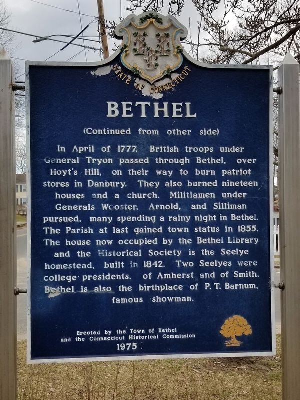
Bethel
When this area was settled, soon after 1685, it was part of its present neighbor, Danbury. As population grew, residents petitioned the General Assembly of the Colony for parish status and a church closer than the center of Danbury. In 1759 . . . — — Map (db m114646) HM
Bridgeport
"The Park City"
The area that is now Bridgeport was settled in the mid-17th century by farmers from the older towns of Stratford and Fairfield. Centers of settlement were Stratfield, present North Avenue; Pembroke, now Old Mill Green; . . . — — Map (db m91834) HM
In 1851, P.T. Barnum and William Noble took the land that we now stand on and developed it. Lots were planned and streets were named after their own family members such as Caroline, Hallet, and of course Barnum. A firm was hired to design an English . . . — — Map (db m227305) HM
Brookfield
Parish of Newbury
The land which comprises the geographical area of Brookfield belonged to the towns of Danbury, Newtown, and New Milford. In 1754 the Parish of Newbury was incorporated by decree of the General Assembly with boundaries . . . — — Map (db m35170) HM
The potato famine of 1846-1851 brought large numbers of Irish immigrants to town. Many purchased homes in the Town Hill neighborhood and St. Peter Church became a focal point for the community.
Germans immigrants were the first major group . . . — — Map (db m71353) HM
Many Danbury land records were destroyed during the British raid of 1777. Historic newspapers, old deeds and early maps help us piece together some of the earliest place names of our city.
Parts of Danbury were lost to Bethel when it broke . . . — — Map (db m71348) HM
Eight families came from Norwalk in 1685 to settle this area which the Indians called Pahquioque. They built their first homes a half mile south of here and made this green their common. The General Court in October 1687 decreed the . . . — — Map (db m22836) HM
• First recorded census taken in 1756, Danbury’s population: 1,527.
• Danbury’s first mayor, elected in 1888, was Lewis LeGrand Hopkins.
• The first train arrived on the tracks of the Danbury & Norwalk Railroad on March 1, 1851.
• . . . — — Map (db m152995) HM
The start of the 20th century saw a continual influx of newcomers to Danbury. A religious census taken in 1916 showed that 27 nationalities and 20 creeds were represented among the 22,533 residents of the town.
The 1910 census shows that a . . . — — Map (db m71473) HM
The first eight families arrived here in 1685; full of hope as they embarked on a new life filled with opportunity. Others soon joined them in this flourishing settlement in a newly born colony.
Most of Danbury’s inhabitants, prior to the . . . — — Map (db m71352) HM
In the spring of the year 1685, the first permanent settlement of Danbury was made. The eight determined families of Samuel Benedict, James Benedict, Thomas Barnum, Judah Gregory, Thomas Taylor, John Hoyt, Francis Bushnell and James Beebe settled . . . — — Map (db m71240) HM
Darien
Originally part of Stamford, this area became Middlesex Parish in 1737. It was incorporated as the Town of Darien in 1820. Settlement had begun about 1700 when the first roads were cut “in the woods.” In 1703 a school district . . . — — Map (db m80136) HM
Telling the Story of Darien
Originally founded as the Darien Historical Society in 1953, the Museum of Darien is dedicated to telling the town's story.
Whether it's a 17th-century blanket chest, a hand-sewn Civil War-era flag, or an . . . — — Map (db m230984) HM
Ring’s End
Landing
Earlier Called Clock’s Landing
Trading Center
Of Middlesex Parish
Part of Stamford from 1641 until
Incorporated as Town of Darien
May 20, 1826
Presented by Kiwanis Club of Darien
As part of 150th . . . — — Map (db m80305) HM
[ front ]
Easton
North Fairfield, a part of the town of Fairfield, was purchased from the Aspetuck Indians in 1670 for thirty pounds and an amount of trucking cloth. In 1762 the Connecticut General Assembly established the parish of . . . — — Map (db m30939) HM
In memory of
Andrew Ward
Born in England 1597
One of the founders of
Wethersfield and Stamford
———
An honored citizen of
Fairfield Conn.
where he died in 1659
———
Member of a Commission . . . — — Map (db m27172) HM
Marker front:
In 1639 Roger Ludlow and five companions, after serving in the Pequot War, purchased from the Indians a rich and abundant expanse of land which they called by the Indian name "Uncowaye." Shortly thereafter the name "Fairfield" . . . — — Map (db m27176) HM
This boulder commemorates
the settlement of Fairfield
by Roger Ludlow in 1639
and the burning of the Town
by the British July 8, 1779.
From the founding of the Town
the religious, military and civic life
of the people
has centered . . . — — Map (db m27227) HM
Welcome to Fairfield’s Historic Town Green
How Did This Green Come to Be? Most New England towns began with a central common "green." Where you are standing is Fairfield's historic center and is as old as the town itself. In 1639 Roger . . . — — Map (db m204367) HM
In
memory of
Revd John Jones
AB MA
The Revd
John Jones
was born in
Southampton England
in 1595 and was a graduate of
Queens College Cambridge
A Puritan divine of the
Church of England he was
the first pastor of the . . . — — Map (db m27174) HM
Father of Connecticut, Author of the Fundamental Orders, Compiler of the Code of 1650, and Pioneer in the Development of American Constitutional Law.
Founded Fairfield and Made His Home Here from 1639 to 1654 — — Map (db m27141) HM
In memory
of
Thomas Sherwood
1586 – 1655
Puritan – Pioneer – Ancestor
A founder of New England
A first settler of Fairfield
Deputy to the General Court
Committeeman
Soldier of the Pequot War
and his wives . . . — — Map (db m27173) HM
This tidal marsh was once part of a network of wetlands that covered hundreds of acres and extended south to Long Island Sound, east to Ash Creek and west to Pine Creek. For centuries the area's native inhabitants, the Unquowa, fished and . . . — — Map (db m204276) HM
In memory of the courageous men
who founded the first settlement of
the Town of Greenwich
in the Connecticut Colony
July 18-1640
Everardus Bogardus •
John Bowers •
Robert Feaks •
Jeffre Ferris •
Angell Husted •
Robert Husted • . . . — — Map (db m18669) HM
The name "Cos Cob Neck" was recorded in 1686. Six Cos Cob roads, including the present Orchard and Bible Streets, were laid out during 1689 northward from the Main Country Road (US 1) into "ye wilderness". A packet boat began to travel regularly . . . — — Map (db m38750) HM
Under the jurisdiction of the New Haven Colony, the first settlers in 1640 purchased land from the Siwanoy Indians. Under New Amsterdam’s protection, this settlement was a dutch manor during 1642–56. In the years 1656–65, it was combined with the . . . — — Map (db m2484) HM
On July 18, 1640, Daniel Patrick and Robert Feaks landed on these shores in the name of the New Haven Colony to start a new settlement, later called Greenwich. This neck of land is called Elizabeth’s Neck after Mrs. Feaks.
The anchor above this . . . — — Map (db m2048) HM
Stepney
ca 1855
Site of the Burr Hawley &
Burritt General Store
At this site farmers assembled horse teams & wagons to bring milk to the milk station & to buy feed, hay and grain; residents purchased sewing supplies, groceries & . . . — — Map (db m25338) HM
[ front ]
Monroe
On May 23, 1823 the General Assembly granted the incorporation of this town and named it in honor of the then President, James Monroe. The town’s roots, however, are much deeper as it was an offspring of the mother-town . . . — — Map (db m26096) HM
This region was established in 1731 as Canaan Parish, a separate ecclesiastical society of the Congregational Churches of Norwalk and Stamford. Incorporated as a town in 1801. New Canaan encompassed the area of Canaan Parish with additional land . . . — — Map (db m46878) HM
Front
In the year 1724 twelve men from Fairfield, Connecticut , came to this area to purchase land from the Indians who then inhabited it. They negotiated with Chief Squantz of the Schaghticoke tribe, who lived near the pond in this . . . — — Map (db m23060) HM
This area, then known as Quanneapague, was purchased from the Pohtatuck Indians in 1705. Settled from Stratford and incorporated in 1711, Newtown was a stronghold of Tory settlement during the early Revolutionary War. French General Rochambeau and . . . — — Map (db m190109) HM
First in recorded history came a navigator, Adriaen Block, in 1614 who called the Norwalk Islands “Archipelago.” In 1640 Daniel Patrick from the New Haven Colony obtained a deed from local Indians conveying land on the west side of the . . . — — Map (db m53449) HM
Norwalk’s first European settlers grazed their cattle on this property – hence the name “Calf Pasture.” Among these earliest arrivals was Matthew Marvin, who moved to Norwalk in 1651 (the year the town was founded). His son, Matthew Jr., bought a . . . — — Map (db m53465) HM
This stone, erected December, 1895, commemorates the purchase from the aboriginal inhabitants, made February 26, 1640-1, by Roger Ludlow, Deputy-Governor of the Colony of Connecticut, framer of its first Code of Laws, and Founder of Norwalk, of . . . — — Map (db m53440) HM
Marvin Elementary School stands on the site of the former homestead of the Marvin-Taylor family, who lived in the 19-room farmhouse for more than 130 years. William Marvin, an ancestor of one of Norwalk’s earliest settlers, built the house in 1836 . . . — — Map (db m53468) HM
Like many small 18th and 19th century burial grounds, the Kellogg-Comstock Cemetery likely served the needs of a single family. The oldest marked grave dates to 1813 and most of the identified interments are related to Enos and Lydia Kellogg, . . . — — Map (db m226765) HM
Home site of
“Lonetown Manor” where
John Read, Gentleman
after whom the town is named
settled in 1711
Title to the original 500 acres
was secured by colony grants
confirmed in 1714 by an Indian
deed from Chief . . . — — Map (db m26870) HM
Originally part of Fairfield and unclaimed land, Redding was settled about 1711, made a parish in 1729, and incorporated in 1767. It was named for John Read, gentleman, lawyer, early landowner, and spokesman for the settlers. One of his land . . . — — Map (db m26814) HM
The Aldrich Contemporary Art Museum acknowledges that it rests on the ancestral homelands of Wappinger and Munsee Lenape Peoples. While these Nations are no longer located on their homelands, The Aldrich is determined to make sure that their history . . . — — Map (db m230107) HM
Looking south from Prospect Street, where the shops and offices of Yankee Ridge are today, stood homes at the beginning of the 20th century. From the left are the Osborn house, owned by Richard Osborn, owner of the Ridgefield Lumber Company; . . . — — Map (db m24807) HM
Ridgebury, "The New Patent," was one of the last land purchases made by the Proprietors. Tradition says that the First Congregational Church in Ridgebury had its beginnings in the "New Patent Meeting House" as early as 1738. In 1768 the . . . — — Map (db m32052) HM
This town was founded in 1708 by a group of families from Norwalk who purchased twenty thousand acres from the Ramapoo Indians for one hundred pounds sterling. They were aided by John Copp, a surveyor, who explored the land now lying between High . . . — — Map (db m23409) HM
Welcome to Ridgefield's History Trail!
Ridgefield, Connecticut – 1708
The Fundamental Orders adopted by Connecticut in 1639 directed would-be settlers, able to support a minister, to establish a settlement, build a Congregational Church . . . — — Map (db m31997) HM
Welcome to Ridgefield's History Trail!
Ridgefield, Connecticut – 1708
The Fundamental Orders adopted by Connecticut in 1639 directed would-be settlers, able to support a minister, to establish a settlement, build a Congregational Church . . . — — Map (db m32234) HM
The First Recorded Plan for settlement was in 1697 when a group of Congregationalists primarily from Norwalk petitioned "to purchase of the Indians a certain tract of land lying about 14 miles northward of the town of Norwalk to settle a . . . — — Map (db m32048) HM
The first surveyors came north from Norwalk to determine the suitability of the land for settlement as a plantation. Tradition says that they spent their first night on top of Settler’s Rock and that fires were built at its base to protect . . . — — Map (db m23420) HM
The Smith Tavern stood on the site of the present library. Ebenezer Smith arrived from Milford in 1709 and was assigned Lot # 26. He opened a small tavern in his home. By 1797 a new building was erected on the site by Amos Smith, who ran a . . . — — Map (db m24806) HM
Built by Benjamin Stebbins for his daughter Sarah and her husband Amos Baker, a Revolutionary War Hero, the first surgeon in Ridgefield and the originator of the famous Baker Apple. — — Map (db m23602) HM
[ front ]
Shelton
1639 – Stratford area settled, with present-day Shelton as the northern part.
1717 – Northern settlers established Ripton parish.
1789 – Ripton separated from Stratford and became the town . . . — — Map (db m25614) HM
Originally part of New Fairfield, which was purchased from the Indians in 1729, the area then known as the Upper Seven Miles was separately incorporated as the Town of Sherman in 1802. The town was named for Roger Sherman who, as a young man, had . . . — — Map (db m23070) HM
This tablet has been placed by Stamford Chapter National Society Daughters of the American Revolution to commemorate
The Settlement of Stamford in 1641
During that year, twenty nine men and their families came from Wethersfield to this place. . . . — — Map (db m38609) HM
Traditional Landing Place of Stratford’s First Settlers
In the spring of 1639 under leadership of the Rev. Adam Blakeman
On the right, at the inner end of the harbor stood the First Meeting House and burial ground, and across the harbor . . . — — Map (db m48426) HM
Academy Hill
Historic District
Established April 14, 1988
First known as Watch House Hill, where the first settlers manned a blockhouse and a palisade to guard the town from threats of Dutch and Indian attack.
Renamed Meeting House . . . — — Map (db m25814) HM
Listed on the National Register of Historic Places
By the United States
Department of the Interior
May 1, 1985
This Estate Owned by the Boothe Family
For Many Generations Was Willed
To the Town of Stratford by
David Beach . . . — — Map (db m25907) HM
This 1820’s home was built over the original foundation of the 1683 house and has been altered four times since then. David and Stephen Boothe’s renovations of 1913 added stained glass windows, four safes in the walls, and several . . . — — Map (db m25911) HM
[Left Plaque]
In honor of
the men and women
who planted in the wilderness
the early homes of Stratford,
who fought bravely and suffered patiently
in the War of the American Revolution,
and who left to their descendents
a . . . — — Map (db m26099) HM
The northwest farmers of Stratford formed the Village of Unity in October, 1725. They united in 1744 with the Long Hill parish of the Stratfield section of Stratford to become the Society of North Stratford. The Society controlled its own religious . . . — — Map (db m88049) HM
[ front ]
Weston
Originally the Nor'field parish of old Fairfield (1639) to the south, present Weston was divided into long lots circa 1670, commencing our agricultural development. By 1757 there were enough families to become a separate . . . — — Map (db m30800) HM
On this site stood an African-American neighborhood hidden behind Main Street and Elm Street. Buildings here were given "½" numbers as street addresses. The residents made up the majority of Westport's African-American population, many of whom . . . — — Map (db m226766) HM
Jennings Trail
Jesup Green
Here stood the William H. Jessup House
Later owned by William Taylor.
On the river the Jessups built wharves
and warehouses in the late 18th
century where grain was stored awaiting
export by sail. The . . . — — Map (db m30645) HM
Indigenous people frequented this area for thousands of years before the arrival of Europeans in the 17th century. In 1637, native Paugussets were driven away after the Great Swamp Fight between the larger Pequot tribe and European colonizers. In . . . — — Map (db m226768) HM
[ front ]
Wilton
Although this region was settled in 1651 as part of Norwalk, the first dwelling house here was built in 1706. The village of Wilton with parish privileges was granted by the general Assembly on May 12, 1726. The Town of . . . — — Map (db m32256) HM
Avon
This area, formerly Northington or the North Parish of Farmington, was settled in 1645non land that had belonged to the Tunxis Indians. It prospered as a farming community and, in 1830, after the construction and opening of the Farmington . . . — — Map (db m33019) HM
Berlin
This land, granted to settlers in 1661 and 1668 by the General Court of Connecticut, was also purchased from the local Mattabesett Indian tribe. Founders of the community include Sergeant Richard Beckley, who came north on the trail from New . . . — — Map (db m46041) HM
Bloomfield
In 1736 fifty-one inhabitants petitioned for parish privileges in what is now Bloomfield. They called the parish Wintonbury, using parts of the names of the three towns they came from Windsor, Farmingtonand Simsbury. It remained . . . — — Map (db m97354) HM
The Village Green
Symbolizing the Beginnings and
Center of Community Life
The Bloomfield Village Green
Has Existed Since the 1700’s
Restored by Wintonbury Park
Redevelopment Project
Wintonbury Parish 1735
Town of Bloomfield 1835 . . . — — Map (db m97283) HM
[ front ]
Bristol
Bristol was originally a part of Farmington. In 1663 an easterly portion called "Poland" was granted to Thomas Barnes and three others. The area which later became Bristol was allotted in 1721 to Farmington settlers. In . . . — — Map (db m33237) HM
New Cambridge (now Bristol)
Was Settled 1727 – 8
Since Early Days
The Federal Hill Green
Has Been Used As A
Training Ground For Soldiers And A
Playground For Children
This Boulder Was Placed
By Katherine Gaylord Chapter . . . — — Map (db m34240) HM
[ front ]
Burlington
The original inhabitants of the part of Farmington known as West Woods were Tunxis Indians. Early settlement by white man was scattered. The first house of record, noted in an estate inventory of 1725, was that of . . . — — Map (db m33174) HM
Settlement of the area later called Canton, originally part of Simsbury, began in 1737 with the erection of the Richard Case II home on East Hill. The earliest homes were constructed along “Cherry’s” brook. The settlers’ name for the . . . — — Map (db m87925) HM
East Granby
This area, first settled in 1664, was one of four Congregational parishes in Simsbury. The Turkey Hills Ecclesiastical Society in 1786 became a section of Granby, and in 1858 was incorporated as the Town of East Granby. An unusual . . . — — Map (db m97408) HM
East Hartford
This part of the lands once inhabited by the Podunk Indians saw its first permanent colonists in 1655, when Thomas Hooker and his followers came from Cambridge, Massachusetts, to found Hartford. The east side of the Connecticut River . . . — — Map (db m74248) HM
East Windsor
Separated from Old Windsor and constituted a township on the “second Thursday of May A.D. 1768”. In this area was the Nortin Society of Old Windsor, organized in May 1752. Ferry service established by John Bissell in 1641 . . . — — Map (db m113964) HM
Enfield
Settled 1680
Established as the township of Enfield, 1683, this area was part of the Springfield Plantation granted to William Pynchon and others by the Massachusetts General Court. Springfield was settled in 1636, but no effectual grants . . . — — Map (db m113909) HM
To Honor the Memory of the Founders of the Town of Enfield. Who led by John Pease, Jr. and his Brother Robert made the First Settlement in 1680.
Placed by Penelope Terry Abbey Chapter, D.A.R.
1680 1930 — — Map (db m113885) HM
Thomas Abbey Born April 11, 1731. Died June 3, 1811.
A soldier in the French and Indian Wars. Took part in the capture of Fort Ticonderoga, 1758, and the conquest of Canada, 1761. Corporal First Regiment, Connecticut Troops, May 25 to . . . — — Map (db m113925) HM WM
On January 16, 1640 the Connecticut General Court empowered a committee to "view those parts by Vnxus Sepus wch may be suitable" for settlement. Soon afterward a small group of families traveled nine miles westward over the hills from . . . — — Map (db m33066) HM
Located at the west end of Farmington, the village of Unionville was first recognized as
such by the U.S. Postal Service in 1834. Earlier it was called Langdon’s Quarter and
then Union District. Residents took full advantage of the Farmington . . . — — Map (db m134927) HM
Formerly part of Wethersfield, the town was named for Glastonbury in England. Its thirty four original farms, running from the River three miles east “into the wilderness,” were the first officially surveyed by Connecticut Colony, . . . — — Map (db m98863) HM
Kimberly Tract
This land is part of the original grant east of the great river made to John Robbins of Wethersfield in 1640. The original lot of 132 acres – 22 rods wide – extended three miles from the river into the hills. With Eleazar . . . — — Map (db m98902) HM
Granby
Settled as the Salmon Brook section of Simsbury early in the 18th century, and established as a separate ecclesiastical society in 1736, Granby became a separate town in 1786. From the beginning, farming was the main endeavor of the . . . — — Map (db m97450) HM
The Corning Fountain was commissioned by John J. Corning as a tribute to his father, John B. Corning. It was designed by John Massey Rhind, a noted sculptor born in Scotland.
The fountain's location was chosen as part of a grand entranceway . . . — — Map (db m230328) HM
Adriaen Block
A short distance from
where you are standing,
in 1614
Adriaen Block, captain of the ship Restless
sails up a river from the Atlantic Ocean
which native peoples of the region have named
"Quinnehtukqut", meaning the Great . . . — — Map (db m53151) HM
In memory of the courageous
Adventurers
who inspired and directed by
Thomas Hooker journeyed through the
wilderness from Newtown (Cambridge)
in the Massachusetts Bay to
Suckiaug (Hartford) – October 1635
Mathew Allyn • John . . . — — Map (db m52432) HM
[ south side ]
George Wyllys
Born 1590 in Fenny Compton Co Warwick England
Came to Hartford 1638
Deputy Governor of Connecticut 1641
And Governor 1642. Died March 9, 1645
Bridget Young his wife died at Fenny Compton
March 1629 . . . — — Map (db m43771) HM
Hartford was named in 1637 after the English town of Hertford. The Indian name was Suckiaug. The first colonial settlement, called House of Good Hope, was made by the Dutch in 1633. The Reverend Thomas Hooker arrived overland from Newtown . . . — — Map (db m43708) HM
In Memory of the First
Settlers of Hartford
Jeremy Adams • Matthew Allyn • Francis Andrews • William Andrews • John Arnold • Andrew Bacon • John Barnard • Thomas Barnes • Robert Bartlett • John Baysey • Thomas Beale • Nathaniel Bearding • Mary . . . — — Map (db m195603) HM
373 entries matched your criteria. The first 100 are listed above. Next 100 ⊳