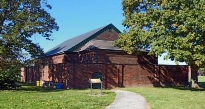
Larger cannon -- and more cannon -- came to Fort McHenry during the Civil War period. To provide safe storage for the additional gunpowder and ammunition, the Army built this magazine in 1864.
From the inside it doesn't look especially . . . — — Map (db m194437) HM
Near East Fort Avenue, on the right when traveling east.
After the Battle of Baltimore in 1814, Fort McHenry continued as a military post for more than a hundred years. The U.S. Army constructed buildings outside the star fort and modified existing structures to serve the needs of the time.
During . . . — — Map (db m10881) HM
Funds for developing new weapons decreased after the Civil War, forcing the Army to upgrade the cannon they already had.
These three 19-inch Rodman gun tubes were probably made during the 1870’s, but their carriages are improved versions . . . — — Map (db m2637) HM
On East Fort Avenue, on the right when traveling east. Reported permanently removed.
This complex of earthen embankments and masonry structures has been the site of Fort McHenry’s heaviest artillery since about 1840. The U.S. Army kept this battery heavily armed during the Civil War to discourage any Confederate attempts to take . . . — — Map (db m194614) HM
Near Constellation Plaza, 0.3 miles east of Wallace Street, on the right when traveling east.
The guns in front of you are the heaviest cannons ever mounted at Fort McHenry. The largest fired exploding projectiles weighing 440 pounds. Mass-produced they represent the "coming of age" of America's iron industry. A special process developed . . . — — Map (db m244386) HM
In 1836, Roger Brooke Taney became Chief Justice of the U.S. Supreme Court and served in this position until his death in 1864. In 1857, he wrote the Dred Scott decision, which stated that African American—enslaved and free--- were property and . . . — — Map (db m101624) HM
On West Franklin Street (U.S. 40) at North Charles Street, on the right when traveling west on West Franklin Street.
In 1817, when Baltimore Town boasted 60,000 inhabitants and Mount Vernon Place was still a forest, a group of leading citizens met in the home of Henry Payson "to form a religious society and build a church for Christians who are Unitarian and . . . — — Map (db m7168) HM
During the Civil War Patterson Park served as a U.S. Army camp, one of several established as part of the Federal occupation of Baltimore. In 1861 the 10th Maine Infantry Regiment occupied Camp Washburn (named for Maine Gov. Israel Washburn) in . . . — — Map (db m61888) HM
On West Pratt Street. Reported permanently removed.
You are standing on the site of the Baltimore and Ohio Railroad’s Mount Clare Shops, a large industrial complex critical to maintaining every aspect of the railroad’s daily operations. Because of their strategic importance, the shops were among . . . — — Map (db m60965) HM
Near West Pratt Street east of South Schroeder Street, on the right when traveling east. Reported permanently removed.
Located approximately one mile west along the B&O Railroad's right-of-way was the site of Baltimore's largest Civil War training camp. Known variously throughout the War as Camp Carroll and Camp Cheesebrough, it was located on property once owned . . . — — Map (db m135970) HM
On South Poppleton Street at West Pratt Street, on the left when traveling south on South Poppleton Street.
The Mount Clare shops of the Baltimore and Ohio Railroad in front of you, built in the 1830s, were part of the B&O Railroad's nerve center during the Civil War, and the rail system was vital to Union victory. Imagine the shops shrouded in the . . . — — Map (db m243530) HM
On West Hamburg Street, on the right when traveling east.
Slavery, segregation, discrimination, and the struggle for equality have defined the African American experience in Baltimore. At the start of the Civil War, Baltimore had 25,680 free blacks-more than any other U.S. city-and only 2,218 slaves. Over . . . — — Map (db m6355) HM
During the Civil War, Baltimore and its environs exemplified the divided loyalties of Maryland's residents. The city had commercial ties to the South as well as the North, and its secessionist sympathies erupted in violence on April 19, 1861, . . . — — Map (db m37537) HM
Near South Howard Street near West Camden Street. Reported damaged.
On April 19, 1861, Confederate sympathizers attacked the 6th Massachusetts Infantry Regiment as it changed trains en route to Washington, which the secessionists hoped to isolate. To learn more about the Baltimore Riot, the city’s role . . . — — Map (db m37538) HM
On West University Parkway. Reported permanently removed.
To the Confederate Women of Maryland
1861-1865
The Brave at Home In difficulty and danger regardless of self they fed the hungry, clothed the needy, nursed the wounded and comforted the dying. — — Map (db m62307) WM
On West University Parkway. Reported permanently removed.
Dedicated in 1917, this monument was part of a national movement spearheaded by the United Confederate Veterans to place a monument recognizing the sacrifices of Confederate women in the capitals of thirteen Southern states. It was founded by the . . . — — Map (db m101757) HM
On West Redwood Street, on the right when traveling east. Reported missing.
Within this cemetery is buried Brig. General Lewis A. Armistead Born New Bern, N.C. Feb. 16, 1817 Died at Gettysburg, Pa. July 3, 1863 Where men under his command made the farthest northern advance by any Southern troops Captain U.S. Army . . . — — Map (db m176185) HM
Near Frederick Avenue (State Highway 144) at Mallow Hill Road, on the right when traveling east.
Four score and seven years ago our fathers brought forth on this continent, a new nation, conceived in Liberty, and dedicated to the proposition that all men are created equal.
Now we are engaged in a great civil war, testing whether that nation, . . . — — Map (db m134999) HM
Near Frederick Road (Maryland Route 144) at Osborne Avenue, on the right when traveling west.
During the Civil War, Baltimore and its environs exemplified the divided loyalties of Maryland’s residents. The city had commercial ties to the South as well as the North, and its secessionist sympathies erupted in violence on April 19, 1861, when . . . — — Map (db m71334) HM
Near Paper Mill Road (Maryland Route 145) 0.3 miles east of Arrowwood Road, on the left when traveling east.
In June 1864, Confederate Gen. Robert E. Lee sent Gen .Jubal A. Early’s corps from the Richmond battlefields to the Shenandoah Valley to counter Union Gen. David Hunter’s army. After driving Hunter into West Virginia, Early . . . — — Map (db m201632) HM
On Viaduct Avenue at Soouth Rolling Road, on the left when traveling north on Viaduct Avenue.
On this site in 1830 a hotel with a waiting room and ticket office was built to serve passengers of the B & O Railroad. Here horses were changed for the final 5-mile trip to Ellicott Mills. Hence the name Relay House. As the B & O Railroad grew the . . . — — Map (db m103010) HM
On Sunshine Avenue, 1 mile east of Harford Road (Maryland Route 147), on the left when traveling east.
When one of Harry Gilmor’s Confederate Cavalrymen (on July 11, 1864) pulled down his Union Flag, Day shot him and then escaped to the woods. They burned his house and barn. — — Map (db m1927) HM
On Clyde Avenue at Baltimore Avenue, on the right when traveling east on Clyde Avenue. Reported permanently removed.
This church is a monument to one Civil Wary veteran’s love for his comrades. Charles W. Hull and his wife, Mary A. Hull, gave the land and the building as a memorial to the men who fought to preserve the Union. The deed stipulated that a memorial . . . — — Map (db m115237) HM
On Clyde Avenue just east of Baltimore Avenue, on the right when traveling east.
This church is a monument to one Civil War veteran's love for his comrades. Charles W. Hull and his wife, Mary A. Hull, gave his land and the building as a memorial to the men who fought to preserve the Union. The deed stipulated that a memorial . . . — — Map (db m240355) HM
On Dulaney Valley Road at Ravenshurst Circle, on the right when traveling south on Dulaney Valley Road.
Civil Engineer, graduated West Point 1822. Among engineer officers sent to assist railroad companies, surveyed first route of B&O, 1827. Resigned commission to pursue distinguished railroad career. Enlisted in Confederate Army after Baltimore riots, . . . — — Map (db m40864) HM
On Quarry Lake Drive at Travertine Drive, on the left when traveling west on Quarry Lake Drive.
Mining operations a the Greenspring Quarry began in the mid 1800s, and the stone was used to build railroad beds for the transportation of supplies during the Civil War. In later years the mined materials were used for construction of the Baltimore . . . — — Map (db m131337) HM
Surgeon General United States Navy, born in Baltimore, Maryland May 21, 1809 and died at Owings Mills, Maryland March 1, 1880. He served his country well.
And in memory of Rosemary Carson, his wife, born in Mercersburg, Pennsylvania November 9, . . . — — Map (db m2071) HM
On Associated Way south of Garrison Forest Road, on the left when traveling north.
Dedicated to all Jewish men and women of Maryland who served in the Armed Forces of the United States of America during War and Peace.
—
American Revolution
Civil War
Spanish-American War
World War I
World War II
Korea . . . — — Map (db m131335) WM
On Dulaney Valley Road at Loch Raven Drive, on the left when traveling east on Dulaney Valley Road.
(preface)
In June 1864, Confederate Gen. Robert E. Lee sent Gen. Jubal A. Early’s corps from the Richmond battlefields to the Shenandoah Valley to counter Union Gen. David Hunter’s army. After driving Hunter into West Virginia, . . . — — Map (db m188720) HM
On Reisterstown Road (Maryland Route 140) at Sudbrook Lane, on the right when traveling north on Reisterstown Road.
Built in 1816 after the close of the War of 1812 as an arsenal. Removed to a point of safety beyond Baltimore. Used during the War between the States and later as a Confederate Home. Now the property of the State of Maryland (1935). — — Map (db m2322) HM
On Cockey’s Mill Road at Reisterstown Road (Route 140), on the right when traveling east on Cockey’s Mill Road.
Chief of the Confederate States Army Signal Corps and Secret Service Bureau, 1862–1865. Appointed Commissioner of Prisoner Exchange with rank of Colonel in April 1865. The Norris Home, “Bookland,” stood 2½ miles south of this . . . — — Map (db m2064) HM
Near Washington Boulevard (U.S. 1) at South Street.
Before you stands the thomas Viaduct, named after Philip E. Thomas, the first president of the Baltimore & Ohio Railroad. This unique bridge has become an enduring symbol of the B&O Railroad and the Patapsco Valley, surviving several floods and . . . — — Map (db m8834) HM
On S. Rolling Road, 0.1 miles south of Francis Avenue, on the right when traveling south.
Created in 1830 as a change point, or "relay," for horses hauling the first scheduled railroad cars in the U.S. The first rail link to nation's capital began here. Thomas Viaduct carries the track across Patapsco gorge; completed in 1835, it is the . . . — — Map (db m8764) HM
On Courthouse Court at Bosley Avenue (Maryland Route 45), on the left when traveling south on Courthouse Court.
Lynching in America
At least 6,500 Black people were the victims of racial terror lynching in the United States between 1865 and 1950. After the Civil War, violent resistance to equal rights for African Americans and an ideology of white . . . — — Map (db m174864) HM
On Charles Street (Route 139) at Charlesbrook Road, on the right when traveling south on Charles Street.
The home of Governor Augustus W. Bradford, which stood on this site was burned July 11, 1864 by Confederate Troops “to retaliate the burning of Governor Letcher’s Home” in Virginia by Federal troops. This was the closest point to . . . — — Map (db m115243) HM
On Cove Point Road (Maryland Route 497) 3.4 miles east of Solomons Island Road (Route 2 / 4) when traveling east.
Built in 1828, the oldest operating lighthouse in Maryland. The prism lens used today was manufactured in Paris and installed in 1897. The original 38-foot tower was built of locally manufactured brick and was raised about 1912 to 51 feet. In 1953 . . . — — Map (db m3440) HM
On Sollers Wharf Road at Wohlgemuth Road, on the right when traveling south on Sollers Wharf Road.
The tract, originally known as Morgan’s Fresh, was granted, 1651, to Philip Morgan, a captain in the Puritan militia. The house, which overlooks St. Leonard Creek, was built before 1670 and served as a lookout station in the War of 1812 and the . . . — — Map (db m3437) HM
On Market Street at North 2nd Street, on the right when traveling west on Market Street.
The 1863 Emancipation Proclamation did not free Maryland's enslaved people, as states that remained in the Union were excluded from the proclamation's provisions. It was Maryland's new constitution, adopted by the narrow margin of 291 votes out . . . — — Map (db m205446) HM
On 2nd Street at Gay Street, on the right when traveling north on 2nd Street. Reported permanently removed.
Divided loyalties and ironies tore at Marylanders’ hearts throughout the Civil War: enslaved African-Americans and free United States Colored Troops; spies and smugglers; civilians imprisoned without trial to protect freedom; neighbors and . . . — — Map (db m168144) HM
On North 2nd Street at Gay Street, on the right when traveling north on North 2nd Street. Reported permanently removed.
Although isolated from Maryland's largest population centers, the Eastern Shore was important to the state's role in the Civil War and exemplified the citizens' divided loyalties.
In the years before the war, enslaved African-Americans here . . . — — Map (db m113505) HM
On River Landing Road, 0.4 miles north of New Bridge Road (Maryland Route 328), on the right when traveling north. Reported missing.
On August 17, 1862, the steamboat Balloon arrived at Denton wharf and disembarked a company of New York infantry and a troop of cavalry. The soldiers quickly arrested twelve prominent local citizens and transported them to imprisonment at . . . — — Map (db m68428) HM
On Market Street at 2nd Street, on the right when traveling west on Market Street. Reported permanently removed.
Maryland slaves were not freed by the Emancipation Proclamation of 1863, which excluded states that remained in the Union from its provisions. It was Maryland's new constitution, adopted by the narrow margin of 291 votes of almost 60,000 cast on . . . — — Map (db m3389) HM
On Crouse Park Lane west of Gay Street (Maryland Route 404), on the right when traveling west.
The Denton wharf, here on the Choptank River, was the site of endless steamboat traffic, escapes of enslaved people on the Underground Railroad, and the arrests of active secessionists during the Civil War.
On August 17, 1862, the steamboat . . . — — Map (db m205463) HM
On North 2nd Street just south of Gay Street (Maryland Route 404), on the right when traveling north.
Welcome to Caroline County! The Civil War intruded into quiet Eastern Shore communities, and residents of this beautiful, water-laced region faced difficult choices.
In the years before the war, enslaved African Americans from the Eastern . . . — — Map (db m205444) HM
On South Main Street (Maryland Route 308) north of Smith Street, on the right when traveling north.
During the Civil War, Maryland's Eastern Shore became a "smuggler's paradise," as coasting vessels from New York made daily runs with contraband goods to the unguarded rivers of Delaware. Cargoes were then carried by wagon to the upper reaches of . . . — — Map (db m137738) HM
On Main Street (Maryland Route 480) at Bernard Avenue, on the left when traveling south on Main Street.
The war divided communities in Maryland, pitting neighbor against neighbor. During Confederate Gen. Robert E. Lee's first invasion of the North, which ended at Antietam, a Greensboro resident wrote to President Abraham Lincoln for assistance on . . . — — Map (db m3398) HM
On Main Street (Alternate Maryland Route 404) 0.4 miles west of Ridgely Road (Maryland Route 480), on the left when traveling west.
The anti-slavery movement was a major factor in the regional contention that led to the Civil War. During the 1840s and 1850s, no individual generated greater support in both America and Europe for that movement than Frederick Douglass. His eloquent . . . — — Map (db m154338) HM
On Linchester Road, 0.1 miles north of Maryland Route 331, on the right when traveling south.
Among the factors that contributed to the coming of the Civil War was the increasing animosity between Southerners and Northerners over the issue of slavery. The operation of the Underground Railroad to help slaves escape to the free North and . . . — — Map (db m5411) HM
On Old Westminster Pike at Sandymount Road, on the right when traveling south on Old Westminster Pike.
An original one acre was deeded in 1827 by Allen and Susannah Baker. Civil War issues divided the congregation in 1856 and Pleasant Grove Church was founded. A log meeting house was replaced in 1867 by a stone structure built of local field stones . . . — — Map (db m36846) HM
On York Street just west of B Street, on the right when traveling west.
First and Second brigades First cavalry division marched from Taneytown to Westminster. The reserve brigade of First cavalry division from Emmitsburg to the field at Gettysburg and the second brigade second cavalry division from Manchester to . . . — — Map (db m223999) HM
On York Street west of B Street, on the right when traveling west.
Headquarters Army of the Potomac moved from Middleburg to Taneytown. First Corps marched from Emmitsburg to Marsh Run. Third Corps from Taneytown to Bridgeport. Fifth Corps from Liberty via Johnsonville Union Bridge and Union to Union Mills. . . . — — Map (db m224000) HM
On Main Street (Maryland Route 30) at Westminster & York Streets, on the left when traveling north on Main Street.
The Second Cavalry Division and the Sixth Corps, Army of the Potomac, camped about Manchester June 30, 1863. Headquarters for Major General John Sedgwick was located on nearby Old Fort School House Road. On the night of July 1, the Corps left . . . — — Map (db m201550) HM
On Manchester Road (Maryland Route 27) 0.3 miles west of Main Street (Maryland Route 30), on the right when traveling west. Reported missing.
On June 29, 1863, Union Gen. George G. Meade ordered the Army of the Potomac to Pipe Creek to counter any move toward Washington or Baltimore by Gen. Robert E. Lee’s Army of Northern Virginia and to engage the Confederates in battle. Meade was . . . — — Map (db m201551) HM
On York Street at Long Lane, on the left when traveling east on York Street.
After Confederate Gen. Robert E. Lee’s stunning victory at Chancellorsville in May 1863, he led the Army of Northern Virginia west to the Shenandoah Valley, then north through central Maryland and across the Mason-Dixon Line into . . . — — Map (db m201631) HM
On Middleburg Road (State Highway 77), on the right when traveling east.
Headquarters Army of the Potomac moved from Frederick to Middleburg. First and Eleventh Corps marched from Frederick to Emmitsburg. Second Corps from Monocacy Junction via Liberty and Johnsville to Uniontown. Third Corps from near Woodsborough to . . . — — Map (db m29504) HM
On Middleburg Road (State Highway 77), on the right when traveling west.
On June 29, 1863, Union Gen. George G. Meade ordered the Army of the Potomac to Pipe Creek to counter any move toward Washington or Baltimore by Gen. Robert E Lee's Army of Northern Virginia and to engage it in battle. Meade was uncertain of Lee's . . . — — Map (db m29498) HM
“Let no vandalism or avarice or neglect, no ravages of time testify to the present or to the coming generations, that we have forgotten as a people the cost of a free and undivided republic.” Gen. John A. Logan 1868. — — Map (db m106838) WM
On South Main Street (Maryland Route 808) just south of Center Street, on the left when traveling north.
Mount Airy was first settled along what is now Ridgeville Boulevard. With the construction of the Old National Pike (Route 40) in the 1730s, Ridgeville became a rest stop and overnight lodging for travelers on the road. In 1831 the Baltimore and . . . — — Map (db m199372) HM
On South Main Street (Maryland Route 808), on the right when traveling north.
In 1839, the Baltimore and Ohio Railroad extended its line through Mount Airy Cut, and a village soon developed here. During the Civil War, Co. K, 14th New Jersey Infantry, guarded the railroad and National Road at Mount Airy. Pine Grove Chapel, . . . — — Map (db m201590) HM
On Main Street (Maryland Route 31) at Green Valley Road, on the left when traveling east on Main Street.
In June 1864, Confederate Gen. Robert E. Lee sent Gen. Jubal A. Early's corps from the Richmond battlefields to the Shenandoah Valley to counter Union Gen. David Hunter's army. After driving Hunter into West Virginia, Early invaded . . . — — Map (db m201629) HM
On Main Street (Maryland Route 31) at Green Valley Road (Maryland Route 75), on the left on Main Street.
In June 1863, as Gen. Robert E. Lee and the Army of Northern Virginia marched north, Gen. J. E. B. Stuart’s Confederate cavalry rode east of the main army. Soon, Federal cavalry hunted Stuart. Gen. David McM. Gregg’s division left Frederick about . . . — — Map (db m244236) HM
On Old Washington Road (Maryland Route 97) 0.2 miles south of Eden Mill Road, on the right when traveling south.
Near here the Confederate cavalry of Major General J.E.B. Stuart entered Carroll County from Cooksville about daybreak June 29, 1863. After damaging the tracks and bridge of the Baltimore and Ohio Railroad at Sykesville, they marched to Westminster . . . — — Map (db m133800) HM
On Main Street (Maryland Route 851), on the right when traveling north.
In June 1863, as Gen. Robert E. Lee and the Army of Northern Virginia marched north, Gen. J.E.B. Stuart’s Confederate cavalry rode east of the main army. Soon, Federal cavalry hunted Stuart. Before dawn on June 29, several former area residents . . . — — Map (db m13883) HM
On West Baltimore Street (State Highway 140) at Park Road, on the left when traveling west on West Baltimore Street.
Headquarters Army of the Potomac moved from Middleburg to Taneytown. First Corps marched from Emmitsburg to Marsh Run, Third Corps from Taneytown to Bridgeport, Fifth Corps from Liberty via Johnsville Union Bridge and Union to Union Mills, Sixth . . . — — Map (db m3004) HM
On West Baltimore Street (State Highway 140) at Park Road, on the left when traveling west on West Baltimore Street.
First Corps marched from Marsh Run, Eleventh Corps from Emmitsburg to Gettysburg, Second Corps from Uniontown via Taneytown to near Gettysburg, Third Corps from Bridgeport via Emmitsburg to the field of Gettysburg, Fifth Corps from Union Mills via . . . — — Map (db m3005) HM
On Maryland Route 140, 0.1 miles east of Bullfrog Road, on the left when traveling west.
As part of General Meade’s screen for Washington as the Confederates invaded Maryland and Pennsylvania, the Third Corps, Army of the Potomac, arrived here June 30, 1863, from Taneytown. Next day General Daniel E. Sickles marched this Corps to . . . — — Map (db m201599) HM
Whitelaw Reid, a Civil War correspondent, began reporting for The Cincinnati Gazette in 1862. On June 30, 1863, Reid took the train from Washington, D.C, and traveled to General George Gordon Meade’s headquarters just outside of Taneytown on the . . . — — Map (db m65131) HM
On Francis Scott Key Highway (Maryland Route 194) 1 mile north of Taneytown Pike (Route 140), on the right when traveling north.
Major General George G. Meade, commander of the Army of the Potomac, maintained headquarters on the nearby Shunk Farm from June 30 until the night of July 1, 1863. From here he directed the initial concentration of the Union forces at Gettysburg. — — Map (db m2996) HM
On West Baltimore Street (State Highway 140) at Park Road, on the left when traveling west on West Baltimore Street.
On June 29, 1863, Union Gen. George G. Meade ordered the Army of the Potomac to Pipe Creek to counter any move toward Washington or Baltimore by Gen. Robert E. Lee’s Army of Northern Virginia and to engage the Confederates in battle. Meade . . . — — Map (db m155348) HM
Union Gen. John F. Reynolds was killed at Gettysburg on July 1, 1863 while directing his command along the Chambersburg Turnpike in the early fighting. His body was carried to a house in town. Orderlies searched for a coffin but found only a too . . . — — Map (db m201605) HM
In 1863, brothers Andrew K. and William Shriver resided on either side of the Littlestown Turnpike here and likewise were divided in their loyalties, with William supporting the Confederacy and Andrew the Union. When officers at the head of Gen. . . . — — Map (db m155368) HM
Near Littlestown Pike (Maryland Route 97). Reported permanently removed.
After stunning victories at Fredericksburg and Chancellorsville, Virginia, early in May 1863, Confederate Gen. Robert E. Lee carried the war through Maryland, across the Mason and Dixon Line and into Pennsylvania. His infantry marched north through . . . — — Map (db m2994) HM
Near Littlestown Pike (Maryland Route 97) 0.4 miles north of Saw Mill Road West, on the right when traveling north.
After stunning victories at Fredericksburg and Chancellorsville, Virginia early in May 1863, Confederate Gen. Robert E. Lee carried the war through Maryland, across the Mason-Dixon Line and into Pennsylvania. His infantry marched north through . . . — — Map (db m155337) HM
On Littlestown Pike (Maryland Route 97) 0.1 miles south of Old Hanover Road, on the right when traveling north.
On June 29, 1863 General J. E. B. Stuart and his cavalry camped here. On June 30, 1863 General James Barnes of the 5th Corps U. S. Army spent the night on his way to Gettysburg. — — Map (db m2991) HM
Near Littlestown Pike (Maryland Route 97) 0.4 miles north of Saw Mill Road West, on the right when traveling north.
At daybreak on June 30, 1863, Gen. J.E.B. Stuart arrived here from his bivouac at the Orendorff farm north of Westminster. He then gathered his brigade commanders to discuss Union Gen. Judson H. Kilpatrick's cavalry division, which was encamped . . . — — Map (db m155339) HM
Near Littlestown Pike (Maryland Route 97). Reported permanently removed.
At daybreak on June 30, 1863, Gen. J. E. B. Stuart arrived here from his bivouac at the Orendorff farm north of Westminster. He then gathered his brigade commanders to discuss Union Gen. Judson H. Kilpatrick’s cavalry division, which was encamped . . . — — Map (db m201547) HM
On Uniontown Road (State Highway 77) at Trevanion Road (State Highway 84), on the right when traveling east on Uniontown Road.
Headquarters Army of the Potomac moved from Frederick to Middleburg. First and Eleventh Corps marched from Frederick to Emmitsburg. Second Corps from Monocacy Junction via Liberty and Johnsville to Uniontown. Third Corps from near Woodsborough to . . . — — Map (db m50088) HM
On Uniontown Road, 0.5 miles east of Maryland Route 84, on the right when traveling east.
On and about the nearby Babylon Farm Major General Winfield Scott Hancock rested his corps June 29, 1863. On July 1, the corps marched through Taneytown to take part in the Battle of Gettysburg. — — Map (db m3013) HM
On Uniontown Road, 0.1 miles Maryland Route 84, on the right when traveling east.
On June 27, 1863, Union Gen. Winfield S. Hancock’s II Corps, Army of the Potomac camped at Monocacy Junction near Frederick. The next day, Gen. George G. Meade assumed command of the army and devised a plan to march it through Frederick and Carroll . . . — — Map (db m3014) HM
The City of Westminster and the citizens of Carroll County proudly honor the brave men of the 1st Delaware Cavalry and the vanguard of Gen. J.E.B. Stuart's cavalry who fought and died during this engagement in the Gettysburg Campaign. We commend the . . . — — Map (db m201548) WM
After the cavalry engagement here on June 29, 1863, Westminster’s citizens cared for dozens of wounded of both sides. Besides the human toll, shattered and broken cannons, gun carriages, and caissons lined both sides of Court Street to Main Street . . . — — Map (db m201634) HM
First and Second Brigades First Cavalry Division marched from Taneytown to Westminster, the Reserve Brigade of First Cavalry Division from Emmitsburg to the field of Gettysburg, and the Second Brigade Second Cavalry Division from Manchester to . . . — — Map (db m13854) HM
Headquarters Army of the Potomac moved from Frederick to Middleburg, First and Eleventh Corps marched from Frederick to Emmitsburg, Second Corps from Monocacy Junction via Liberty and Johnsville to Uniontown, Third Corps from near Woodsborough to . . . — — Map (db m13856) HM
On Main Street (Maryland Route 32) at Washington Road (Maryland Route 32), on the right when traveling south on Main Street.
Here June 29, 1863, Captain Charles Corbit led Companies C and D, First Delaware Cavalry, against General J. E. B. Stuart’s cavalry division. Though repelled by overwhelming force, the attack delayed Stuart, and was a factor in his failure to reach . . . — — Map (db m3024) HM
On East Main Street (Maryland Route 32), on the right when traveling east.
In June, 1863, as Gen. Robert E. Lee’s infantry marched through Maryland on its second invasion of the North, Lee lost contact with Gen. J.E.B. Stuart as the cavalry commander led his force east and north around the Union army. Here, on the . . . — — Map (db m13832) HM
On Liberty Street (Maryland Route 27) at West Main Street (Maryland Route 32), on the right when traveling north on Liberty Street. Reported permanently removed.
A block away, at what is now 71 East Main Street, stood the Abner Neal house. In August 1862, Federal soldiers arrested sixteen Westminster residents as Southern sympathizers and escorted them to Baltimore for questioning. The group, soon released, . . . — — Map (db m114404) HM
During the Civil War, some Westminster families supported the Confederacy while others stood by the Union. Among the latter was Mary Ann “Mollie” Huber, who organized a dozen other like minded ladies into a sewing circle that met at her house. . . . — — Map (db m201643) HM
On South Center Street, on the right when traveling south. Reported damaged.
On June 29, 1863, Confederate Gen. Robert E. Lee’s infantry was in Pennsylvania, and Gen. J.E.B. Stuart’s cavalry arrived here on the outskirts of Westminster. Gen. Fitzhugh Lee’s division led the column, which numbered 6,000 including cavalrymen . . . — — Map (db m13826) HM
On Emerald Hill Lane just north of Longwell Avenue, on the right when traveling north.
In June 1864, Confederate Gen. Robert E. Lee sent Gen. Jubal A. Early's corps from the Richmond battlefields to the Shenandoah Valley to counter Union Gen. David Hunter's army. After driving Hunter into West Virginia, Early invaded . . . — — Map (db m201507) HM
On East Main Street at North Court Street, on the right when traveling east on East Main Street.
After stunning victories at Fredericksburg and Chancellorsville, Virginia, early in May 1863, Confederate Gen. Robert E. Lee carried the war through Maryland, across the Mason and Dixon Line and into Pennsylvania. His infantry marched north through . . . — — Map (db m75738) HM
On Liberty Street (Maryland Route 27) at East Main Street, on the left when traveling south on Liberty Street. Reported permanently removed.
After stunning victories at Fredericksburg and Chancellorsville, Virginia, early in May 1863, Confederate Gen. Robert E. Lee carried the war through Maryland, across the Mason and Dixon Line and into Pennsylvania. His infantry marched north . . . — — Map (db m114403) HM
On East Main Street north of Longwell Avenue, on the right when traveling north.
Site of Abner Neal home. His sons, Henry and Frank, were arrested on Aug. 28, 1862 as Southern supporters. Released, they joined the Army of Virginia and returned with Stuart's advance guard on June 29, 1863, en route to Gettysburg.
Here, Brig. . . . — — Map (db m188573) HM
On East Main Street at Lincoln Road, on the left when traveling north on East Main Street.
Built in 1854 as an Odd Fellows Hall and served as an "Opera House" and community center for nearly a century. Reported to have been used by Union troops during the Civil War.
Opera House printing company located here in 1976 by its owner, . . . — — Map (db m103704) HM
On West Main Street at Carroll Street, on the left when traveling north on West Main Street.
After Confederate Gen. Robert E. Lee's smashing victory over Union Gen. John Pope at the Second Battle of Manassas, Lee decided to invade Maryland to reap the fall harvest, gain Confederate recruits, earn foreign recognition of the . . . — — Map (db m201697) HM
On East Main Street south of Manchester Avenue, on the right when traveling north.
The Trumbo-Chrest House
has been placed on the
National Register
of Historic Places
by the United States
Department of the Interior — — Map (db m114397) HM
1324 entries matched your criteria. Entries 101 through 200 are listed above. ⊲ Previous 100 — Next 100 ⊳