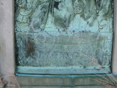
[Inscription on the street (east) side]
This Memorial Arch was erected
AD MCMXVIII to the memory of
William Hunt Perry
of Bridgeport Conn by his wife
Harriet Adelaide Perry
[Inscription on the park side]
This Memorial . . . — — Map (db m27166) HM
There are monuments located throughout our city that serve as a reminder of those who have served our country.
The dedication of the Civil War Soldier’s Monument took place on May 27, 1880 in City Hall Square. The 32-foot high granite . . . — — Map (db m71246) HM
The History of
Memorial Boulevard
In 1919, after the "Great War", Bristol was growing and needed a new high school. Albert F. Rockwell took the initiative and made a remarkable offer to the city. He would give 12 acres in Dunbar Meadows (north of . . . — — Map (db m33622) HM
Nation's oldest continuously operating ferry. Since 1655, public transportation across the Connecticut River has been provided at this site, connecting the towns of Rocky Hill and Glastonbury, both formerly parts of Wethersfield. Motive power has . . . — — Map (db m45766) HM
Silas Deane House
Has been Designated a
Registered National
Historic Landmark
Under the Provisions of the
Historic Sites Act of August 21, 1935
This Site Possesses Exceptional Value
In Commemorating and Illustrating
The History of . . . — — Map (db m46178) HM
Webb House
Has been Designated a
Registered National
Historic landmark
Under the Provisions of the
Historic Sites Act of August 21, 1935
This Site Possesses Exceptional Value
In Commemorating and Illustrating
The History of the . . . — — Map (db m46177) HM
The Warham Mill was established by Mr. John Warham, first minister to the Windsor Church, in 1640. The Mill has been in continuous use as a grist mill to the present day. Tradition says it was the first grist mill in Connecticut. — — Map (db m219574) HM
[ panel 1 ]
Welcome to Squire's Tavern
Home to the Barkhamsted Historical Society
and the Farmington River Coordinating Committee
The Barkhamsted Historical Society
Squire's Tavern, like the nearby river, has a story to . . . — — Map (db m31204) HM
Coe Memorial Park
The Homestead Of
Lyman Wetmore Coe and his wife Eliza Seymour Coe
Given in Their Memory to the Town of Torrington
By their Children
Edward Turner Coe • Ella Seymour Coe • Adelaide Coe Godfrey •
-------------
To make . . . — — Map (db m30097) HM
ASM International - The Materials Information Society - has designated the Eli Whitney Armory an historical landmark. "On this site between 1798 and 1825, Eli Whitney built the first significant independent American armory. The development of . . . — — Map (db m28750) HM
Erected on September 21, 1925, Meriden’s Traffic Tower was an innovative traffic control device designed to provide safe travel for the vehicles and pedestrians of the growing city. The unique character of the tower quickly made it a local . . . — — Map (db m26642) HM
New Haven Green
Has Been Designated A
National
Historic Landmark
This Site Possesses National Significance
Commemorating the History of the
United States of America
1971
National Park Service
United States Department of the . . . — — Map (db m35172) HM
Renovation of the New Haven Green
1986 – 1990
Laid out in the 1638 plan for the New Haven Colony, this 16-acre green is the physical and symbolic heart of the city and has borne witness to its most important historic events. In 1983, the New . . . — — Map (db m35425) HM
This 16.5-acre outdoor space is the central square of the nine squares originally designed in 1638 by the settlers of the New Haven Colony as a common space for cultural, civic, religious and educational purposes and gatherings. It is one of the . . . — — Map (db m227293) HM
This 16.5-acre outdoor space is the central square of the nine squares originally designed in 1638 by the settlers of the New Haven Colony as a common space for cultural, civic, religious and educational purposes and gatherings. It is one of the . . . — — Map (db m227295) HM
This 16.5-acre outdoor space is the central square of the nine squares originally designed in 1638 by the settlers of the New Haven Colony as a common space for cultural, civic, religious and educational purposes and gatherings. It is one of the . . . — — Map (db m227296) HM
This 16.5-acre outdoor space is the central square of the nine squares originally designed in 1638 by the settlers of the New Haven Colony as a common space for cultural, civic, religious and educational purposes and gatherings. It is one of the . . . — — Map (db m227301) HM
This 16.5-acre outdoor space is the central square of the nine squares originally designed in 1638 by the settlers of the New Haven Colony as a common space for cultural, civic, religious and educational purposes and gatherings. It is one of the . . . — — Map (db m227302) HM
Built and launched in New Bedford in 1841, the Charles W. Morgan is the last of an American whaling fleet that numbered more than 2,700 vessels over 150 years. During an 80-year whaling career, the Morgan embarked on 37 voyages. . . . — — Map (db m227038) HM
Buried 8-18-1984 by
Union Historical Society
Uncover 8-19-2034
This was the stepping stone
to The Center School C. 1844
Plaque gift of Gertrude and Maurice Chappell — — Map (db m123874) HM
Laid out by Petrus Stuyvesant, Dutch Governor, 1655. On this green stood the old jail and gallows. Here were held the great fairs and weekly markets from early times. — — Map (db m3423) HM
After decades of dispute over property boundaries, the proprietors of the provinces of Maryland and Pennsylvania hired English astronomers and surveyors Charles Mason and Jeremiah Dixon to "run out, settle, and define" the boundaries between the . . . — — Map (db m243667) HM
Education for ALL, Past and Present: Iron Hill School, No. 112C
The Past:
The Iron Hill School #112C, was one of the schools built for black school children in Delaware by philanthropist Pierre S. duPont as part of a $100 million dollar . . . — — Map (db m189506) HM
[1st plaque]
Eleutherian Mills
This is Eleutherian Mills, where E.I. du Pont built his home in 1803. Here also is the restoration of E.I. du Pont's garden, as well as a workshop, vehicle and weather vane exhibits in the Barn,
and the . . . — — Map (db m213322) HM
The highest bench mark monument in Delaware is located on Ebright Road. This horizontal control mark denotes an elevation of 447.85 feet above sea level. The Delaware Geological Society through its relationship with the National Geodetic Survey has . . . — — Map (db m128088) HM
This is the marker from which Charles Mason and Jeremiah Dixon started the survey for the famous Mason-Dixon Line that separates Delaware from Maryland, Pennsylvania, and New Jersey.
This marker was settled in 1750 by John Emory and Thomas Jones, . . . — — Map (db m95336) HM
Saving an Historic Landmark
The Bethesda Methodist Episcopal Church was built in 1879 to replace an older chapel. This rural country church is an excellent example of the Greek Revival style of architecture. Although it was . . . — — Map (db m198870) HM
Erected By The
State of Delaware
To Commemorate The Settlement
On This Spot, Of The First
Dutch Colony, Under De Vries,
A.D. 1631.
Here was the cradling of a state.
"That Delaware exists as a separate
Commonwealth is due to . . . — — Map (db m37400) HM
A temporary light was established on the south end of the recently completed National Harbor of Refuge Breakwater on January 1, 1902. It was replaced in 1908 by a three-story frame lighthouse. A series of storms damaged the structure, resulting in . . . — — Map (db m39374) HM
Lightship LV-118
Overfalls
has been designated a
National Historic Landmark
This vessel possesses national significance in commemorating the history of the United States of America
Used from 1820 to 1983, lightships . . . — — Map (db m232749) HM
700 Jackson Place has been designated a National Historic Landmark This site possesses national significance in commemorating the history of the United States of America National Park Service 1974
From 1910 to 1948 it served as the first . . . — — Map (db m32879) HM
Metropolitan African
Methodist Episcopal Church
Was organized 1822, rebuilt in 1838 and completed in 1880.
This site possess exceptional value in commemorating the Religious Life of the Negro in the United States of America. . . . — — Map (db m10191) HM
Renwick Gallery
has been designated a
Registered National
Historic Landmark
under the provisions of the
Historic Sites Act of August 21, 1935,
This site possesses exceptional value
in commemorating or illustrating
the . . . — — Map (db m73812) HM
Every President of the United States since President James Madison has attended occasional services here. Many of them were communicants of the parish.
This building was completed in 1816 from plans of Benjamin Henry Latrobe.
an adjacent . . . — — Map (db m39126) HM
Andrew Mellon Building has been designated a National Historical Landmark This site possesses national significance in commemorating the history of the United States of America.
1977
National Park Service United States Department . . . — — Map (db m40505) HM
The General Federation of Women’s Clubs is an international women’s organization dedicated to community improvement by enhancing the lives of other through volunteer service. Founded in 1890, it is one of the world’s largest and oldest . . . — — Map (db m32128) HM
Founded by Samuel Harrison Smith and later published by Joseph Gales, Jr. The National Intelligencer for 65 years was a leading journal in the nation's capital, a vital force in the country's political life, a principal source of information about . . . — — Map (db m51471) HM
This rock marks the place where Gen. Edward Braddock landed on April 14, 1755 with the British Expeditionary Force. This force was sent from England to fight in the French and Indian War. Shortly after arrival, Gen. Braddock moved his troops into . . . — — Map (db m197126) HM
Samuel Davidson, a Scot of original character, purchased the site and built Evermay, 1792-1794, with proceeds of the sale of lands he owned which include part of the present site of the White House and Lafayette Square. Davidson was buried in a . . . — — Map (db m33792) HM
Alfred Lee, one of Georgetown's more prosperous African Americans, began operating a store in the center market near Constitution and 7th Street about 1830. In 18670, looking to expand his business, Alfred purchased several M Street properties and . . . — — Map (db m240110) HM
When Western High School—today the Duke Ellington School for the Arts—was built in 1898. African Americans in the Old Brinetown neighborhood around 35th Street and Reservoir Road were displaced to create housing for white families. The expansion of . . . — — Map (db m198645) HM
The first Baptist church established in Georgetown was funded in 1862 by the Reverend Sandy Alexander (1818-1902), a former slave who led the church until 1889. Among the founding members was Collins Williams, a preacher from Fredericksburg, . . . — — Map (db m33773) HM
Georgetown
Historic District
has been designated a
Registered National
Historic Landmark
under the provisions of the
Historic Sites Act of August 21, 1935
This site possesses exceptional value
in commemorating and . . . — — Map (db m130) HM
Mt. Zion United Methodist Church, the First Black Methodist Church in Washington, D.C., founded October 16, 1816, is designated a District of Columbia Historic Landmark. It was listed in the National Register of Historic Places on July 24, 1975. — — Map (db m177949) HM
Listed on the United States Register of Historic Places and
an officially designated Landmark of the District of Columbia
Maintained by the Jewish Historical Society of
Greater Washington as the
Lillian and Albert Small
Jewish Museum . . . — — Map (db m29797) HM
U.S. Soldiers' Home has been designated a National Historic Landmark This site possesses national significance in commemorating the history of the United States of America
1974 National Park Service United States Department of the . . . — — Map (db m52839) HM
Built in 1799, in the hope that the new capital would become a great city.
Opened as a tavern and inn by William Rhodes, 1801.
Washington's first 'town hall,' where White House architect James Hoban and other citizens met to petition . . . — — Map (db m39618) HM
Built in 1902, the original Woodward & Lothrop "Woodies" Department Store fronting on G Street was designed by nationally recognized architect Henry Ives Cobb and remains a striking example of the Gilded Age in Washington, DC. The first two . . . — — Map (db m131773) HM
Third Baptist Church
2008 Historic Landmark
Calvin Brent, Architect
has been placed on the
National Register
of Historic Places
by the United States
Department of the Interior — — Map (db m245018) HM
The Washington Monument honors George Washington, hero of the American Revolution and first president of the United States. When this stunning stone obelisk was completed in 1884, it was the tallest building in the world. Today the monument . . . — — Map (db m211345) HM
The thoroughfare where this box is located was originally known as Ridge Road, as it follows the hillside above the Potomac Palisades. In the late 19th century, it was renamed in honor of cannon manufacturer Henry Foxall.
The fire box stands . . . — — Map (db m187485) HM
Ben's Chili Bowl, founded in 1958 by Ben and Virginia Ali, is one of the oldest continuous businesses on U Street. It is also one of the few to survive both the assassination of the Reverend Martin Luther King, Jr., and the years of the disruptive . . . — — Map (db m20341) HM
The oldest active post in the Marine Corps, Marine Barracks Washington, D.C., was founded in 1801 by President Thomas Jefferson and the second commandant of the Marine Corps, Lt. Col. William Ward Burrows. Better known as "8th & I," the Barracks . . . — — Map (db m210266) HM
A key event in the landmark 1954 school desegregation case Brown v. Board of Education occurred here at Sousa Junior High (now Middle) School. In 1950 Sousa was one of several new DC schools for white children. When Spottswood T. Bolling, . . . — — Map (db m187431) HM
The Washington Monument honors George Washington, hero of the American Revolution and first president of the United States. When this stunning stone obelisk was completed in 1884, it was the tallest building in the world. Today the monument . . . — — Map (db m211343) HM
Erected 1847-57. Designed by James Renwick, Jr. in twelfth century Romanesque style for the first offices, research laboratories, exhibits, collections, and lectures of the Smithsonian Institution. Dedicated to the increase and diffusion of . . . — — Map (db m46413) HM
Devil’s Millhopper
has been designated a
Registered Natural Landmark
This site possesses exceptional value
as an illustration of the Nation’s natural
heritage and contributes to a better
understanding of man’s environment
. . . — — Map (db m125200) HM
Prohibition ended in 1933. In the mid-1930s, when gambling was legal on Hollywood Boulevard, Wellons & McGowan held a license for slot machines at this address. Shortly after that, it was acquired by Breeding's for a liquor store. — — Map (db m99788) HM
Ichetucknee Springs
Has been designated a
Registered Natural Landmark
under the provisions of the
Historic Sites Act of August 21, 1955
this site possesses exceptional value
in illustrating the natural history of the United . . . — — Map (db m126019) HM
In 1912, following the drowning of a prominent citizen, Dr. Lyman Haskell and Clarence MacDonald established and trained Florida’s first U.S. Volunteer Life Saving Corps (VLSC) at this location to protect the lives of bathers on Jacksonville Beach . . . — — Map (db m93262) HM
Bunnell Water Tower has been placed on the National Register of Historic Places in 2019 by the United States Department of the Interior — — Map (db m209101) HM
The Apalachicola Arsenal, originally known as the Mt. Vernon Arsenal, was built by the United States Army and served as an arms depot during the Second Seminole Indian War. Construction began in 1832, and was completed in 1839. The original compound . . . — — Map (db m79625) HM
The Apalachicola Arsenal, originally known as the Mt. Vernon Arsenal, was built by the United States Army and served as an arms depot during the Second Seminole Indian War. Construction began in 1832, and was completed in 1839. The original compound . . . — — Map (db m79626) HM
Mark Welch "Mr. Pat" Munroe built the Pat Munroe House for his first wife, Edith Adelaide Walker, in 1893. The couple had 10 children before her death in 1896. Mr. Pat later married Mary Frances Gray in 1912. Eight children were born from this . . . — — Map (db m79622) HM
This structure has been
recorded by the
Historic American
Buildings Survey
of the United States Department
of the Interior for its Archives
at the Library of Congress — — Map (db m30453) HM
Francisco Ferlita, a native of Santo Stefano, Sicily, established a bakery on this site in 1896. Bread sold for three cents and five cents, and often on credit. In 1922 the wooden structure was destroyed by fire, and a yellow brick building was . . . — — Map (db m8703) HM
Vincente Martinez-Ybor, a wealthy Spanish
cigar manufacturer from New York and
Key West, began development of Ybor City
in 1885. On April 12,1886, 500 Cuban cigarmakers
boarded the sidewheeler Hutchinson in
Key West and sailed for Tampa. . . . — — Map (db m31712) HM
The first healthcare facility in Florida for African-Americans was the Florida A&M College (FAMC) Hospital, known as the Florida A&M University (FAMU) Hospital after 1953. The school's original two-story, 19-bed wooden sanitarium was built in 1911 . . . — — Map (db m79624) HM
The House of Representatives commends the Florida Bicentennial Commission for making possible the placement of the Liberty Bell here where the public may see the bell and reflect upon the liberty the bell symbolizes. On November 19, 1974, House . . . — — Map (db m73010) HM
Since 1917, the Westcott Fountain has been the symbolic landmark of the rich heritage and traditions of the Florida State University and its predecessor institution, the Florida State College for Women. A gift of the classes of 1915 and 1917, the . . . — — Map (db m234556) HM
In 1539, a Spanish expeditionary force led by Hernando de Soto landed in the Tampa Bay area. Nearly 600 heavily armed adventurers traveled more than 4000 miles from Florida to Mexico intending to explore and control the Southeast of North America. . . . — — Map (db m79522) HM
Visible behind you, Stuart's water tower rises above the tree line as you gaze down historic Osceola Street.
The water tower was constructed in 1959. The American flag first appeared encircling the tank as suggested by the Martin County High . . . — — Map (db m193648) HM
This “lighthouse” which has never seen the sea, serves as a testament to Coral Gables’ early boom years, a time when everyday practical things could be turned into works of art. Built c. 1923, its design is credited to Denman Fink, . . . — — Map (db m73629) HM
Biltmore Hotel
has been designated a
National Historic Landmark
This site possesses national significance
in commemorating the history of the
United States of America
1996
National Park Service
United States . . . — — Map (db m75726) HM
The Silver Palm District named for the small silver-backed fronds that grew profusely in the surrounding pine forest, was the first area south of Cutler opened for settlement. In 1900, Charles Gossman, Charles Hill and William Anderson filed the . . . — — Map (db m73327) HM
The Seminole Theater has been designated a City of Homestead Historic Landmark
This building, originally constructed in 1921, was subsequently restored in 1940 with an Art Deco facade following a devastating fire. The theatre was mainly used as . . . — — Map (db m73365) HM
Preserving the Mound
Florida is home to a rich variety of cultural resources that represent our society. Many significant archaeological sites, like the Fort Walton Temple Mound, are in public ownership.
The preservation of the temple . . . — — Map (db m99254) HM
A state of the art facility when it was built in 1926, this filling station was part of the 1920's automobile boom that opened the area to its first real influx of new residents and tourists. With masonry vernacular construction, it is an excellent . . . — — Map (db m243146) HM
This monument is the last remaining part of the Kelsey City Gates. The structure towered over the current Old Dixie Highway, at Watertower Road and proclaimed Kelsey City (Lake Park) as the “Gateway to the Palm Beaches.” . . . — — Map (db m153509) HM
Flagler Park, formerly known as City Park, has been an important public space in West Palm Beach since the founding of the community. The town site for West Palm Beach was laid out in 1893 as a grid pattern of streets running north - south and . . . — — Map (db m181816) HM
Whitehouse Road marks the south boundary of land settled about 1842 by James Gibbons under the Armed Occupation Act. The first Fort Dade Post Office was established there in 1845. In that year, Gibbons' widow, Mary, wed William Kendrick, Captain of . . . — — Map (db m10474) HM
This tree replaces the original hundred year old tree that was the "mail drop" for the Bone Valley area before the city of Mulberry, "The Phospate Center of the World" was incorporated in 1901. — — Map (db m4981) HM
In 1768, James Grant (1720-1806), Governor of British East Florida from 1763 to 1773, established Grant's Villa Plantation at the juncture of the Guana and North Rivers. Enslaved Africans cleared the 1,450-acre tract of land, planted indigo seeds, . . . — — Map (db m80967) HM
This building, designed by architect F. A. Hollingsworth, opened in 1953 as the St. Johns County Jail, replacing an earlier jail building on San Marco Avenue that subsequently became a tourist attraction. A decade later, this building played a . . . — — Map (db m40728) HM
The Spanish built Fort Matanzas in 1740-42 to control Matanzas inlet, the "back door" to St. Augustine.
Much earlier, in 1565, Spain had bloodily crushed here a French challenge to her control of Florida by killing the remnants of a French colony . . . — — Map (db m127607) HM