Marshallton was named in honor of Humphry Marshall, noted 18th century scientist and stone mason, whose botanical garden and home are adjacent to the Center House property. Humphry’s name appears on many of the tavern license petitions, and he . . . — — Map (db m194230)
One of the first nurserymen in the nation and the author of the first book on North American trees and shrubs. Arbustum Americanum: The American Grove. Marshall is known as the Father of American Dendrology. He regularly supplied native . . . — — Map (db m194231) HM
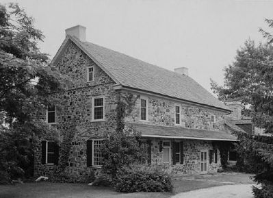
The Marshalton Inn
Licensed 1822
Has Been Placed on the
National Register of Historic Places
By The United States
Department of the Interior
Constructed c. 1793 — — Map (db m191789) HM
Major General John Sullivan sent a message to George Washington, stating that reports of a British attempt to cross the Brandywine north of the Continental Army were false. Sullivan met “Major Joseph Spear of the Militia who came (last night) . . . — — Map (db m194375)
What sort of food was served at the Center House?
To date, no specific food has been linked to this particular tavern, but Joseph Martin would probably have provided 18th century Anglo-Welsh American “country food,” best described as . . . — — Map (db m194417)
Trimbleville, circa 1740, was named after Irish immigrant James Trimble. Located along the 1728 Great Valley Road, the hamlet grew up around one of Chester County’s earliest grist mills, powered by the Broad Run. Due East, on the Brandywine Creek, . . . — — Map (db m194566) HM
For over 250 years, a building has stood on this site. First a house, probably built in 1750 for William and Abigail Clayton. In 1764, Joseph Martin built an addition and opened The Center House, or Martin's Tavern. For 200 years it functioned as a . . . — — Map (db m194378)
An important Indian trail, key to Pennsylvania's fur trade in the 17th century, crossed the present highway near here. It linked trading posts on the lower Schuylkill and Indian towns to the west. The Dutch, Swedes, and English fought one another . . . — — Map (db m40994) HM
The Great Trail of the Minquas or Susquehanna Indians from the Susquehanna to the Schuylkill crossed the present road about this point. It was the path prior to 1670 for their conquest of the Lenni-Lenape or Delaware Indians and for trade with the . . . — — Map (db m8249) HM
Okehocking Indian Town
The Chiefs
Pokhais, Sepopawny, and Muttagooppa
With their people of the Unami Group
* Their Totem * The Tortoise *
Of the Lenni – Lenape or Delawares
were moved from lower Ridley and Crum Creeks
by . . . — — Map (db m159371) HM
Name of Shawnee-Delaware Indian village located here. From Braddock's defeat in 1755 until Fort Augusta was built in 1756, it was a rallying point for Indians hostile to the English. — — Map (db m167150) HM
The Riviere aux Boeufs of the French, renamed by George Washington in 1753. It had an important part in the French and Indian War and the settlement of northwestern Pennsylvania. — — Map (db m175465) HM
Major George Washington was 21 years old and a loyal British subject when he was sent by the governor of Virginia, Robert Dinwiddie, on a dangerous diplomatic mission into western Pennsylvania. Governor Dinwiddie had heard reports that the French . . . — — Map (db m232151) HM
In commemoration of
Col. William Crawford
born in Virginia in 1732,
burned at the stake
by the Delaware Indians
near Sandusky, Ohio, June 11, 1782
Revolutionary soldier,
friend and companion of Washington,
brave and . . . — — Map (db m132138) HM
Major George Washington was 21 years old and a loyal British subject when he was sent by the governor of Virginia, Robert Dinwiddie, on a dangerous diplomatic mission into western Pennsylvania. Governor Dinwiddie had heard reports that the French . . . — — Map (db m175235) HM
Essential to the growth of an early frontier town, this vigorous stream provided power to early mill wheels and water for fire fighting, and fed the French Creek Feeder Canal. By 1910 it was built over and largely lost to view. — — Map (db m132118) HM
Founded about 1762 by John Rigbie and Co. Operated after 1781 by Michael Ege, noted ironmaster of the period. Ruins of the charcoal furnace still stand. — — Map (db m27002) HM
South Middleton Township is located on the southern side of the Cumberland Valley in the shadow of the South Mountain. The area’s natural beauty, rich farmland, abundant water resources, and historical and recreational assets have attracted . . . — — Map (db m202191) HM
Legislator and official lived here in Lowther Manor on land conveyed by the Penns in 1771. At the state's 1787 convention to ratify the U.S. Constitution, Whitehill led the Anti-federalist minority; he presented amendments later embodied in the Bill . . . — — Map (db m26955) HM
The Native American tribes of Pennsylvania and Ohio, who had long traded with the English, asked for Pennsylvania's help to prevent French incursions and trade abuses in the Ohio territory. The Pennsylvania Assembly voted to give aid to the . . . — — Map (db m15793) HM
Founded in 1751 as the seat of Cumberland County. Historic old frontier town. Supplied a contingent for the first regiment of the Continental Army in 1775. March against the Whiskey Rebels began here, 1794. — — Map (db m30318) HM
Founded in 1751 as the seat of Cumberland County. Historic old frontier town. Supplied a contingent for the first regiment of the Continental Army in 1775. March against the Whiskey Rebels began here, 1794. — — Map (db m35806) HM
First fort authorized by Pennsylvania. Laid out by Gov. Morris, July, 1755, “in the middle of this town,” on news of Braddock's defeat. Col. John Armstrong's headquarters till 1758. Called “Fort Lowther” by some later writers. — — Map (db m16075) HM
Before the erection of Cumberland County - 1750 - this site was the intersection of the Indian trail leading from mountain to mountain across Groghan's Gap westward.
With the laying out of Carlisle in 1751 the square became the center of the . . . — — Map (db m15866) HM
1. Cumberland County, established in 1750, lost its first courthouse to fire in 1845. This Courthouse was built in 1846 and still bears the scars of a Civil War shelling on July 1, 1863.
2. Carlisle's long tradition of education began early, . . . — — Map (db m16094) HM
This square was set apart by the Penns, in 1751, for the Church of England; in continuous use since that time by St. John's Episcopal Church. In 1752, the first church building was erected. — — Map (db m15789) HM
Many of the early settlers of Pennsylvania were Scots-Irish who brought with them their Presbyterian faith. By the early 1730's they were settling the Cumberland Valley, including the fertile land near the Conodoguinet Creek. In 1734, Presbyterians . . . — — Map (db m30296) HM
Congregation organized 1734. Erection of this building begun 1757. Oldest building in Carlisle. Here July 12, 1774, colonists met and declared for American independence.
No. 2 — — Map (db m153869) HM
To capture Fort Duquesne, General Forbes marched an army, in 1758, from his main base at Carlisle to the forks of the Ohio. He followed as closely as he could with army wagons, the Raystown Indian and Traders Path, widened by axemen under Colonel . . . — — Map (db m30322) HM
Early Carlisle physician, member of Provincial Convention, Revolutionary officer, commander at Fort Pitt, occupied house that stood on this site before 1800. — — Map (db m19433) HM
In 1753, Benjamin Franklin stayed at inn on this site while he, Richard Peters, and Isaac Norris treated with Indians. Hamilton and Knox, members of Washington's cabinet, lodged here in 1794. — — Map (db m15861) HM
In their 1751 plan for Carlisle, the Penn family designated a portion of the Square to be used as a market. From 1751 until 1952 a market was held on this spot. Markets were held twice a week, and were overseen by the Clerk of the Market who was . . . — — Map (db m19490) HM
The Old Graveyard was Carlisle's first burial ground. The earliest surviving marker is dated 1757, six years after Carlisle's founding in 1751. Title from the Penn family for the original “three acres, three quarters, and fifteen perches” for the . . . — — Map (db m19494) HM
Revolutionary war period gunsmith Thomas Butler, Sr., emigrated from Dublin, Ireland with his wife Eleanor Parker Butler and three sons. Originally settling in Lancaster, the Butlers moved their residence to this site, known as Lot #61 on the . . . — — Map (db m185765) HM
Near Pittsburgh, on July 9, 1755, a French and Native American force decimated a small British and colonial army led by Edward Braddock, opening all of Pennsylvania to Indian raids. The Delaware tribe, under their leader Shingas, raided, killing and . . . — — Map (db m15796) HM
On this lot Thomas Butler had his home and gunshop about 1764; the latter still stands to the rear. Butler and five sons, all officers, served in the Revolution. Often referred to as the “Fighting Butlers.” — — Map (db m16071) HM
The first battalion in the colonies authorized by Congress, June, 1775. Totaling nine companies, it was initially led by Col. William Thompson of Carlisle. Later the organization became the First Pennsylvania Continental Regiment. — — Map (db m217126) HM
Smallpox at Quebec
In December 1775, over a thousand Continental Army Soldiers, under the command of General Benedict Arnold and General Richard Montgomery, assembled outside Quebec. The men were tired and weak from a long, cold march. Like . . . — — Map (db m104608) HM
After the defeat of General Edward Braddock at the Battle of the Monongahela in July of 1755, (the battle that launched the French and Indian War in North America,) French and Native American forces unleashed a series of raids on the Pennsylvania . . . — — Map (db m217304) HM
A redoubt is a small temporary fortification of entrenched earth and wood. These battlefield strongpoints were designed to provide cover for defending infantry and artillery as well as slow down an attacking force. Several construction elements . . . — — Map (db m217274) HM
Founded in 1751 as the seat of Cumberland County. Hisoric old frontier town. Supplied a contingent for the first regiment of the Continental Army in 1775. March against the Whiskey Rebels began here, 1794. — — Map (db m16074) HM
Irish immigrant and land speculator who launched one of the largest and most effective British trade networks in America in the 1740s. From his original trading post on this site, Croghan expanded as far as the French-controlled Ohio Country. He . . . — — Map (db m217028) HM
Scots-Irish immigrant who amassed wealth as a merchant and slave trader and contributed the modern equivalent of several million dollars to the Revolutionary War. Believing control of the West pivotal to America's future, he negotiated to open . . . — — Map (db m217026) HM
Who came with their family from England in about the year 1725 and settled on this land having secured title to twenty-one sections.
They are buried at Meeting House Springs Graveyard near Carlisle, Penns.
James died June 6th, 1772
Jane died . . . — — Map (db m163606) HM
Original log meeting house was erected 1737 near the Big Spring. Church was fully organized, October 1738. Present stone structure was built 1789, and in 1790 the trustees laid out Newville as a town on the church-owned glebe. — — Map (db m122376) HM
Grist mill built about 1763 by William Laughlin. Owned by his family until 1896. Preserved by Ethel T. McCarthy. The oldest such structure remaining in this region — — Map (db m84040) HM
In 1755 supplies for Braddock’s army were stored here in Edward Shippen’s strong stone house “at the back Run.” James Burd, the son-in-law of Shippen, opened a road to carry these supplies to the west. After Braddock’s defeat the remaining supplies . . . — — Map (db m1018) HM
Named for Gov. R.H. Morris, and built by local settlers under the supervision of James Burd after Braddock’s defeat in July, 1755. Later garrisoned by provincial troops commanded by Hugh Mercer. The fort site, long marked by the soldiers’ well, lies . . . — — Map (db m18627) HM
“Widow Piper’s Tavern,” used for Cumberland County court-sessions, 1750-1751, until a court house was erected at Carlisle, the county seat. The house is now the home of the Shippensburg Civil Club. — — Map (db m18628) HM
The First
Court House
of
Cumberland
County
1735 - 1928
Home of the
Civic Club
[Additional plaque below:]
The property has been
placed on the
National Register
of Historic Places
by the . . . — — Map (db m152337) HM
This tablet is placed as a memorial to Edward Shippen founder of Shippensburg, Benjamin Franklin, Robert H. Morris, and James Burd, names forever associated with this Burrough, all of whom were members of this Apostolic communion.
By such . . . — — Map (db m152340) HM
Erected in November 1755 by Col. James Burd and used as one of the chain of forts to protect the frontiers during the period of Indian hostility following the defeat of General Edward Braddock. — — Map (db m1019) HM
Founded 1730 by Edward Shippen. Second oldest town in the state west of the Susquehanna River. Important community on colonial frontier. Temporary seat of Cumberland Co., whose first courts were held here in 1750-51. — — Map (db m84019) HM
In commemoration of
the sacrifice and service
of the men of Middle Spring
Patriots-Pioneers
Builders
Site of First Log Church
1738 — — Map (db m18529) HM
The earliest resolves for independence in the State. Drawn June 4, 1774, by Col. Timothy Green and eight Hanover Township patriots. They committed their cause to "Heaven and our Rifles" — — Map (db m31307) HM
On the river bank, a short distance west
of this stone, was the landing place of
Harris’ Ferry,
the most historic crossing place on the
Susquehanna. A great part of the early
migration into Western Pennsylvania and
the Ohio Valley . . . — — Map (db m121983) HM
Built by John Harris Jr., founder of Harrisburg, in 1764-66. It was Simon Cameron's home, 1863-89, and many famous people visited there. It is now home of the Dauphin County Historical Society. — — Map (db m6598) HM
Here lies John Harris, Sr., father of the founder of the City of Harrisburg, who emigrated from Yorkshire England in the early 18th Century to share in the opportunities of William Penn's new world. First locating in Philadelphia, Harris made his . . . — — Map (db m6596) HM
John Harris was born in Yorkshire County, England in 1673. A brewer by trade, he came to Philadelphia in 1694 and spent a few years in there working at removing stumps and building and clearing city streets.
Harris became a friend of Edward . . . — — Map (db m121991) HM
The Story as reported by Robert Harris, grandson of John Harris, Sr., in 1828.
Around 1720, a band of Indians stopped at the Harris trading post requesting rum. John Harris refused to grant them. In anger, they tied Harris to a nearby . . . — — Map (db m121993) HM
Native peoples lived in the Susquehanna Valley thousands of years before the arrival of John Harris Sr. In the 16th Century, the Susquehannocks, an Iroquoian speaking people, initially inhabited the northern waters of the Susquehanna River. The . . . — — Map (db m121989) HM
The Paxton Boys and the End of the Resident Indians in the Lower Susquehanna Valley – 1763
By 1763 only one Indian settlement remained below Shamokin in Pennsylvania’s lower Susquehanna Valley. A small settlement of twenty Conestoga . . . — — Map (db m121990) HM
Although the original Borough of Harrisburg and its oldest neighborhoods comprise the area now occupied by the Central Business District, the city's oldest structure is ironically located at its eastern end amidst 20th Century development. This . . . — — Map (db m6887) HM
A tract of 1272 acres, now this part of Harrisburg, was first surveyed in 1732 for Thomas Penn, and was known as Paxtang Manor. It was sold, 1760, to three colonial settlers: Thomas Simpson, Thomas Forster, Thomas McKee. — — Map (db m159630) HM
Stockaded blockhouse, built 1755-56, on the site of present Fort Hunter Museum. Used to protect the frontier and as a supply base in building Fort Augusta. Abandoned and fell to ruins after 1763. — — Map (db m1511) HM
Prior to European settlement this land was inhabited by the Susquehannock and Delaware Indian tribes. *Around 1750 Samuel Hunter married the widow Catherine Chambers and settled here to run her gristmill. *The Fort at Hunter’s Mill or Fort Hunter . . . — — Map (db m85934) HM
Slavery was entwined with Pennsylvania’s earliest colonial history. Governor William Penn, founder of the colony in 1681, owned eleven enslaved people. A century later, Pennsylvania passed the 1780 Gradual Emancipation law. This allowed for the . . . — — Map (db m85972) HM
Frontiersman known as the “Great Renegade” was born nearby. Captured by Indians, 1756, he lived among the Senecas and learned their language and culture. Following his release, he became an interpreter for the American army; deserted in 1778. . . . — — Map (db m1587) HM
At the birth of the United States in the 1770s, slavery was firmly embedded in its fabric. Blacks stolen from Africa were shipped to America as part of a lucrative trade system. Most enslaved people lived in the South, but about 10% lived in the . . . — — Map (db m85973) HM
A short way from here is early 18th century Paxton Church. The first pastor was installed in 1732. In the churchyard are buried John Harris, founder of Harrisburg, Senator William Maclay, and many other eminent leaders. — — Map (db m6821) HM
Founded in 1729; the first pastor, William Bertram, installed in 1732 by Donegal Presbytery. Its grove was patented to it by the sons of William Penn in 1741. The churchyard is the oldest pioneer graveyard in this region. — — Map (db m122385) HM
Oldest pioneer graveyard in Dauphin County. Here, near Pastors William Bertram and John Roan, lie heroes of the French and Indian Wars and the Revolution; and Colonel John Rodgers, a signer of the Hanover Resolves in 1774. — — Map (db m7157) HM
At Union Deposit, just to the north, can be seen the remains of the canal. It united the Susquehanna at Middletown with the Schuylkill at Reading. Suggested by William Penn, the canal was surveyed 1762, in use by 1828, abandoned in 1885. — — Map (db m7158) HM
Hummelstown was laid out in 1762 on the same tract originally patented by Robert Chambers in 1744 and deeded to Frederick and Rosina Hummel. At the same time, it was called Frederickstown. Hummel's original draft of Frederickstown shows the center . . . — — Map (db m137396) HM
The Conestoga wagon
was a sturdy wagon used by American pioneers. The wagon was named for the Conestoga Valley in Pennsylvania where it was first built during the early 1700's. Conestoga wagons carried most of the freight and people that moved . . . — — Map (db m137413) HM
Cornerstone laid July 13, 1767, and dedicated in 1769 by Henry Melchior Muhlenberg, patriarch of American Lutheranism. Church erected on ground provided by George Fisher, the founder of Middletown, for annual rental of "one grain of wheat." — — Map (db m7167) HM
The oldest town in Dauphin County; laid out in 1755 by George Fisher, Quaker. It was an important port at the junction of the Pennsylvania and Union Canals in the 19th century. Site of early flour, lumber, and iron industries. — — Map (db m7165) HM
This boulder stands on "Pine Ford", the ancestral home of George Fisher, founder of Middletown in 1755, the land having been granted to his father by the Penns in 1747.
About 300 feet east spanned by a modern structure known as Fisher's Bridge, . . . — — Map (db m223929) HM
About two miles north is the site of this pioneer Presbyterian church founded in 1736. First pastor was Richard Sankey. In the graveyard are buried many first settlers and veterans of frontier wars and the American Revolution. — — Map (db m122386) HM
This marker is placed on the site of the original log church building erected by the Paxton Congregation about 1716. The top stones of this marker formed a part of the building supports and were excavated on this location. — — Map (db m137419) HM
Organized as a congregation in 1732, with William Bertram as first pastor. The second pastor was the famed "Fighting Parson," John Elder. In the churchyard are buried John Harris, Jr., William Maclay and other notables of this region. — — Map (db m6822) HM
The first building on this site, a log structure, was erected about 1716. Regular pastorate was established in 1726. The present stone building was erected in 1740 and was restored in 1931. It is the oldest Presbyterian Church building in continuous . . . — — Map (db m122383) HM
Designer of the frigate Constitution, "Old Ironsides," lived 1803-38 in the Pont Reading House, which stands opposite. The present house was built at dates 1683 to 1813. — — Map (db m81492) HM
Chichester Meeting for Worship was established in 1682 and began holding monthly meetings in 1684. The current unimproved fieldstone meetinghouse was built in 1769 and replaced an earlier c. 1688 log structure that was destroyed by fire. A . . . — — Map (db m157344) HM
Upper Chichester Township. “Chichester Liberty” was established in 1683 by William Penn. Upper Chichester Township separated from Lower Chichester Township in 1759.
The Upper Chichester area was claimed both by the Swedes (1643) . . . — — Map (db m154914) HM
Thomas Massey left England on the ketch "Endeavor" arriving at Upland (Chester) 1683. Married Phebe Taylor 1692, bought 900 acres in Marple Township and build this brick house in 1696. — — Map (db m81574) HM
Built by noted Quaker, Jonathan Maris, c. 1750, this fieldstone farmhouse retains many early features such as a walk-in cooking fireplace and six corner fireplaces. The property was purchased by Robert Culbertson after the civil war and remained . . . — — Map (db m159613) HM
The Maris family came from England in 1682 and settled in Springfield, Delaware County. Family descendants settled in Marple Township and built this fieldstone farmhouse about 1800. It remained a residence until its conversion to a business in the . . . — — Map (db m159614) HM
A fine example of early Pennsylvania rural architecture. Brick section was built before 1708 by Thomas Massey, who by 1696 was owner of a 300-acre “plantation” here. An earlier central wooden section was replaced by stone about 1730 by . . . — — Map (db m81572) HM
John Chads, heir to his father's 500-acre plantation along the Brandywine,
commissioned a house, made of Brandywine bluestone, to be built on
banks of the creek. The style and appointments of the house suggest
moderate wealth. Its simplicity . . . — — Map (db m197399) HM
The Chads' Springhouse predates the home of John Chads across the street. It was built to be both a springhouse and a residence with a corner fireplace in the living area and a sleeping loft above. It was probably built by John Wyeth Jr., the . . . — — Map (db m73827) HM
1102 entries matched your criteria. Entries 201 through 300 are listed above. ⊲ Previous 100 — Next 100 ⊳