Marker Logo HMdb.org THE HISTORICAL
MARKER DATABASE
“Bite-Size Bits of Local, National, and Global History”


After filtering for Ontario, 172 entries match your criteria. The first 100 are listed.                                               The final 72 


Notable Buildings Topic

 
Wilfred Laurier University Carnegie Building<br>(<i>northwest elevation</i>) image, Touch for more information
By Cosmos Mariner, May 24, 2022
Wilfred Laurier University Carnegie Building
(northwest elevation)
1 Ontario, Brant County, Brantford — Judge Alexander David Hardy — 1859-1951
On George Street just south of Wellington Street, on the left when traveling south.
. . . Map (db m215795) HM
2 Ontario, Durham Region, Clarington, Bowmanville — Church and Temperance Street, circa 1880 — Historic Bowmnville
On Church Street at Temperance Street, on the right when traveling east on Church Street.
Prior to moving to Church Street, Bowmanville's first fire hall stood in the location of our present Town Hall. With no horse team of their own, a $10.00 reward was offered to the owner of the first team of horses to arrive at the hall during a . . . Map (db m245133) HM
3 Ontario, Durham Region, Oshawa — Parkwood
Near Simcoe Street North (Durham Regional Road 2) just south of Parkwood Court, on the right when traveling south.
[English] A rare surviving example of the grand estates of the inter-war years, Parkwood consists of a richly decorated house set in 12 acres of grounds. The house, originally constructed in 1916-1917 to the designs of the Toronto . . . Map (db m208899) HM
4 Ontario, Essex County, Windsor — Original Home of Major F.A. Tilston V.C. Armoury
On University Avenue East at Freedom Way, on the right when traveling east on University Avenue East.
This armoury was named after Major Fred Tilston, a true military hero of this community. Maj. Tilston, a member of the Essex Scottish, was awarded the Victoria Cross, the highest award for bravery, for his exploits at the Battle of Hochwald Forest . . . Map (db m42292) HM
5 Ontario, Haldimand County, Cayuga — Judicial Complex, Haldimand County — Historical Building
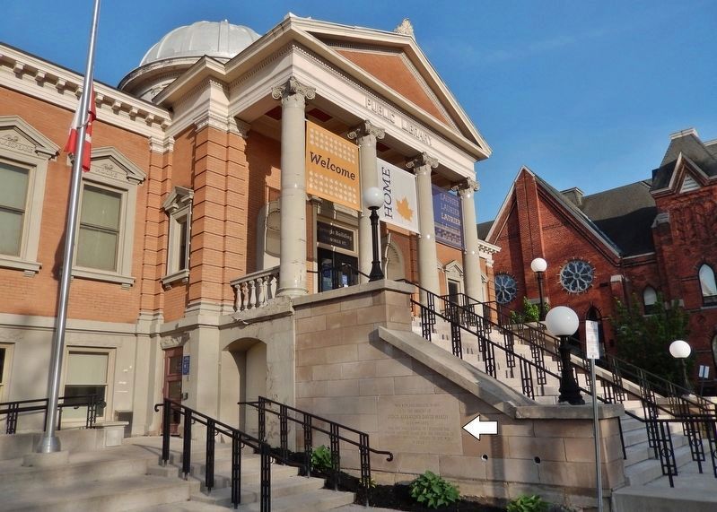
On Munsee Street North, 0.2 kilometers north of Echo Street West, on the right when traveling south.
Judicial Complex, Haldimand County Court House, 1923, Jail 1850-51, Registry Office 1871, Jailer's Residence 1877 Built as part of the original judicial complex, the stone jail was designed by Cumberland and Ridout. The registry office . . . Map (db m235119) HM
6 Ontario, Halton Region, Acton — Acton Town Hall
On Willow Street North at Bower Street, on the right when traveling north on Willow Street North.
Designed by James, Mallory and Mallory and built by Wm. McCulla, this Italianate styled hall was officially opened in 1883. Built to reflect the aspirations of a small community it was preserved through local effort in 1977.Map (db m196187) HM
7 Ontario, Halton Region, Milton — Former Milton Town Hall
On Main Street East at Charles Street, on the right when traveling west on Main Street East.
This building served as the Town Hall from September 1867 to June 1985. Built by Joseph Martin in 1865 for a cost of $5,000, it was known as Milton Town Hall and Market House.Map (db m196185) HM
8 Ontario, Hamilton, Burlington Heights — Dundurn Castle
Near York Boulevard just north of Dundurn Street North, on the right when traveling north.
This villa was completed in 1835 for Allan Napier MacNab. Incorporating an existing farmhouse, it was designed by the local architect, Robert Wetherell, as a statement of its owner's place in Hamilton society. The house features an eclectic blend . . . Map (db m66126) HM
Paid Advertisement
9 Ontario, Hamilton, Burlington Heights — Dundurn Castle — — 1832 —
On York Boulevard just north of Dundurn Street North, on the right when traveling north.
This mansion was built 1832-35 by Allan Napier MacNab (1798-1862) and named after the family ancestral seat in Scotland. Enlisting at fifteen, MacNab distinguished himself by his bravery in the War of 1812. He subsequently entered politics and was . . . Map (db m66129) HM
10 Ontario, Hamilton, Dundas — The Dundas Town Hall
On Main Street at Dundas Street (County Road 99), on the left when traveling north on Main Street.
Dundas was incorporated as a town in 1847 by a special Act of the legislature of the Province of Canada. The following year the town council accepted a tender from a local builder, James Scott, to erect a stone town hall and voted £2000 to cover the . . . Map (db m196237) HM
11 Ontario, Hamilton, Waterdown — Waterdown Memorial Hall
On Dundas Street East (Hamilton Regional Road 5), 0.1 kilometers east of Main Street North, on the right when traveling west.
In 1919 a "Community League" was organized with the goal of constructing a building to function as both a memorial to citizens who had enlisted in World War I (1914-1918) and as a community hall. The Waterdown Women's Institute purchased this . . . Map (db m243593) HM
12 Ontario, Kenora District, Dryden — Hambleton House
On Van Horne Avenue just north of King Street, on the right when traveling north.
Built in 1897 by J. S. McFadyenMr. McFadyen built several of the town’s early buildings including the first jail & council chamber in 1904.Map (db m243242) HM
13 Ontario, Lambton County, Petrolia — Victoria Hall
On Greenfield Street close to Petrolia Line, on the right when traveling south.
English When Victoria Hall was built in 1889, Petrolia, in the midst of an oil boom, was one of the wealthiest towns in Canada. The opulent town hall reflects this stage in the town’s growth. While its first floor housed municipal offices, . . . Map (db m78421) HM
14 Ontario, Lanark County, Almonte — Former Almonte Post Office
On Mill Street at Little Bridge Street, on the right when traveling west on Mill Street.
Begun in 1889 and finished in 1891, this building was erected to house postal and customs services. Federal chief architect Thomas Fuller was responsible for the design and Robert Cameron was the contractor. The building was part of a national . . . Map (db m104019) HM
15 Ontario, Lanark County, Almonte — The Rosamonds in Almonte
On Mill Street at Almonte Street (County Highway 16), on the right when traveling west on Mill Street.
In 1857 James Rosamond built this mill on the Mississippi River, thereby firmly establishing the woollen industry in Almonte. An Irish-born entrepreneur, Rosamond was previously a resident of nearby Carleton Place where, in 1846, he had built one . . . Map (db m104009) HM
16 Ontario, Lanark County, Carleton Place — Canadian Pacific Railway Station
On Coleman Street just east of Franktown Road, on the left when traveling east.
Carleton Place Heritage Property Designated under the Ontario Heritage ActMap (db m234447) HM
17 Ontario, Lanark County, Carleton Place — Carleton Place Town Hall
Built between 1895 and 1897 for a cost of $26,000, our Town Hall was designed in the Richardson Romanesque style by Toronto architect George King. It replaced the original Town Hall built in 1872 on Edmund Street. The chateau style . . . Map (db m234392) HM
Paid Advertisement
18 Ontario, Lanark County, Carleton Place — Post Office and Federal Building
On Bridge Street just west of Albert Street, on the right when traveling west.
The first post office was established in town in 1830. That same year, the name of the community changed from Morphy's Falls to Carlton Place, and then, through a slip in typing, to Carleton Place. By 1890, the growth of the town was . . . Map (db m234052) HM
19 Ontario, Lanark County, Perth — "Summit House"
On Drummond Street East at Harvey Street, on the right when traveling west on Drummond Street East.
This house was built in 1823 by James Boulton, one of Perth’s first lawyers. Modelled after "The Grange" in Toronto, the house was designed in the Adamesque style, which was popular in Upper Canada during the 1820’s, with overtones of the . . . Map (db m207798) HM
20 Ontario, Lanark County, Perth — Carnegie Library (McMillan Building) — Perth Designated Heritage Building
On Gore Street East (County Highway 43) at Basin Street, on the right when traveling west on Gore Street East.
[Title is text]Map (db m207781) HM
21 Ontario, Lanark County, Perth — Code's Mill — 1902 — Perth Designated Heritage Site —
On Herriot Street just west of Gore Street East (County Highway 43), on the right when traveling west.
[Title is text]Map (db m233770) HM
22 Ontario, Lanark County, Perth — Doran-Riverside Building — c 1850 — Perth Designated Heritage Site —
On Gore Street East (County Highway 43) at Tay Street, on the right when traveling west on Gore Street East.
[Title is text]Map (db m207761) HM
23 Ontario, Lanark County, Perth — Kellock Block — Perth Designated Heritage Building
On Gore Street East (County Highway 43) at Herriot Street, on the left when traveling east on Gore Street East.
[Title is text]Map (db m233747) HM
24 Ontario, Lanark County, Perth — Matheson House / La Maison Matheson
On Gore Street East just east of Foster Street, on the left when traveling east.
Built in 1840 of local sandstone, the Matheson House is an outstanding example of early Scottish-Canadian architecture. Its design is imposing, its stonework remarkably fine, and it occupies a key position in one of the best surviving . . . Map (db m233817) HM
25 Ontario, Lanark County, Perth — Matthews Building — Perth Designated Heritage Site 1850 — Heritage Conservation Easement Site/Site Patrimonial Protιgι Par Une Servitude —
On Gore Street East (County Highway 43), on the left when traveling east.
1981 Regional Award of Honour for the preservation of Matthews Building, Ontario ————————————— The heritage character and integrity of this property are protected by a legal agreement between the owner and the Ontario Heritage . . . Map (db m233867) HM
26 Ontario, Lanark County, Perth — McMartin House / La Maison McMartin — c./vers 1831
On Gore Street East (County Highway 43) at Harvey Street, on the right when traveling west on Gore Street East.
The son of Loyalists from the Morrisburg area, Daniel McMartin (1798-1869) established a law practice in Perth in 1823. Well-educated and well-connected, he acquired clients like timber baron Philemon Wright of Hull. McMartin chose a . . . Map (db m207667) HM
Paid Advertisement
27 Ontario, Lanark County, Perth — McMartin House / Maison McMartin
On Harvey Street at Gore Street East (County Highway 43), on the right when traveling north on Harvey Street.
Begun in 1830 for barrister Daniel McMartin (1798-1869), this imposing house symbolizes the wealth and social aspirations of this member of the Tory elite. Born at Williamsburg of Loyalist stock, McMartin attended John Strachan's . . . Map (db m207662) HM
28 Ontario, Lanark County, Perth — Old Fire Hall — 1855 • Perth Designated Heritage Site • 1883
On Herriot Street just north of Gore Street East (County Highway 43), on the right when traveling north.
[Title is text]Map (db m233868) HM
29 Ontario, Lanark County, Perth — Perth Town Hall / l'Hτtel de Ville de Perth — 1863 — Perth Designated Heritage Site —
On Gore Street East (County Highway 43) at Market Square, on the left when traveling west on Gore Street East.
Perth's stately town hall is an enduring expression of the vitality and importance of local governments in the 19th century. Erected in 1863-1864, shortly after the town's incorporation, it recalls an era when such buildings served as . . . Map (db m207771) HM
30 Ontario, Lanark County, Perth — St. Andrew's Presbyterian Church — 1927 — Perth Designated Heritage Site —
On North Street (County Highway 10) at Drummond Street West, on the right when traveling north on North Street.
[Title is text]Map (db m233975) HM
31 Ontario, Lanark County, Perth — St. George Hotel — 1836 — Perth Designated Heritage Site —
On Harvey Street at Drummond Street, on the left when traveling north on Harvey Street.
1836. Perth Designated Heritage Site.Map (db m207794) HM
32 Ontario, Lanark County, Perth — The Old Perth Post Office / The Crain Building
On Gore Street East (County Highway 43) at Basin Street, on the right when traveling west on Gore Street East.
The Old Perth Post Office The buildings that were previously built here were torn down in 1913, after the government bought a vacant lot from John A. Stewart and three adjacent buildings on this corner. The property sat unused for twenty . . . Map (db m207769) HM
33 Ontario, Lanark County, Perth — The Prince of Wales Prize / Le Prix du Prince de Galles
On Gore Street East (County Highway 43) at Market Street, on the left when traveling west on Gore Street East.
For outstanding stewardship of the built heritage ——————————————————————— Attestation d'excellence en gestion du patrimoine bβtiMap (db m207776) HM
34 Ontario, Lanark County, Perth — Thomas Wright Building — Perth Designated Heritage Building
On Gore Street East (County Highway 43) at Colborne Street, on the left when traveling east on Gore Street East.
[Title is text]Map (db m233866) HM
35 Ontario, Lanark County, Smiths Falls — 14 — Town Hall / L'Hτtel de Ville — The Heritage Trail / Le sentier du patrimoine — Remembering Our Historic Past / Nous souvenant de notre passι historique —
On Beckwith Street North (Provincial Highway 15) at Church Street, on the right when traveling north on Beckwith Street North.
Town Hall The Town Hall was built in 1859 in the Classical Revival Style to house the municipal offices and council chambers of Smiths Falls including the Police and Fire Departments. In later years there were additions to the building such . . . Map (db m124512) HM
Paid Advertisement
36 Ontario, Leeds and Grenville United Counties, Brockville — A view of Brockville from the waterfront CPR Docks — 1896 — Brockville Historic Area: The Brock Trail —
On Block House Island Road just south of Water Street, on the right when traveling south.
This photograph, taken in 1896, is of particular interest because it documents buildings that no longer exist or that have been altered by the passage of time. The grouping of buildings in the lower-left corner were standing on the . . . Map (db m141617) HM
37 Ontario, Leeds and Grenville United Counties, Brockville — Amanda & Joseph P. Deacon House — built 1870-72
On James Street East at Bethune Street, on the left when traveling east on James Street East.
Attorney & Police MagistrateMap (db m147038) HM
38 Ontario, Leeds and Grenville United Counties, Brockville — Bartholomew and Ruth Ann Carley House — c. 1830
On King Street East (County Highway 2) just east of East Avenue, on the right when traveling east.
[Title is text]Map (db m146910) HM
39 Ontario, Leeds and Grenville United Counties, Brockville — Buell, Donaldson, and Ross Buildings — ca. 1910 — Brockville Historic Area: Our Past —
On King Street West (County Highway 2) at Buell Street, on the left when traveling east on King Street West.
Brockville's new concrete granolithic sidewalks and electric arc street lamps are in place.Map (db m146947) HM
40 Ontario, Leeds and Grenville United Counties, Brockville — Capt. Thomas Hayes House — c. 1851
On Water Street West at Apple Street, on the right when traveling west on Water Street West.
Capt. Thomas Hayes House, c. 1851.Map (db m146994) HM
41 Ontario, Leeds and Grenville United Counties, Brockville — Charles E. Jones House — c. 1858
On Ormond Street just south of Wellington Street, on the left when traveling south.
Gentleman Son of the Hon. Charles JonesMap (db m146907) HM
42 Ontario, Leeds and Grenville United Counties, Brockville — Chipman-Page House — built ca. 1877
On Pine Street just east of Bethune Street, on the left when traveling east.
• Built by Abigail & Lewis Chipman about 1877 • Owned 1896-1933 by Olivia & J. Albert Page, a Lawyer and Police MagistrateMap (db m147069) HM
43 Ontario, Leeds and Grenville United Counties, Brockville — Christina & Thomas Campbell House — built ca. 1830
On King Street East (County Highway 2) at Orchard Street, on the right when traveling east on King Street East.
Clerk of the County Court for 40 years. Died 1857. Academy for Young Ladies, 1857.Map (db m147072) HM
44 Ontario, Leeds and Grenville United Counties, Brockville — Cossitt Terrace — 1894
On King Street (County Highway 2) at Park Street, on the right when traveling east on King Street.
Built for Newton Cossitt Architect: George A. AllanMap (db m141564) HM
Paid Advertisement
45 Ontario, Leeds and Grenville United Counties, Brockville — Daniel Derbyshire House — c. 1865
On Pine Street at Orchard Street, on the right when traveling east on Pine Street.
Businessman and SenatorMap (db m147061) HM
46 Ontario, Leeds and Grenville United Counties, Brockville — David Simpson House — c. 1880
On King Street East (County Highway 2) just east of East Avenue, on the right when traveling east.
[Title is text]Map (db m146908) HM
47 Ontario, Leeds and Grenville United Counties, Brockville — Dr. Thomas McQueen House — c. 1840
On Broad Street just south of King Street West (Provincial Highway 2), on the right when traveling south.
[Title is text]Map (db m146990) HM
48 Ontario, Leeds and Grenville United Counties, Brockville — East Ward Fire Engine House — 1862
On King Street (County Highway 2) just east of Garden Street, on the left when traveling east.
The home of Defiance Fire Co. No. 2 Designed by Samuel Hazlewood, Surveyor & Civil EngineerMap (db m141571) HM
49 Ontario, Leeds and Grenville United Counties, Brockville — Elizabeth and James Hall House — c. 1820
On Perth Street at James Street West, on the left when traveling south on Perth Street.
James St. was named after him in 1832.Map (db m147027) HM
50 Ontario, Leeds and Grenville United Counties, Brockville — Former Brockville Post Office
On Court House Avenue (County Route 29) at William Street, on the right when traveling south on Court House Avenue.
Completed in 1886 this structure was designed under the direction of Thomas Fuller, Chief Architect of the Department of Public Works from 1881 to 1896. The Brockville Post Office shows the sensitivity often displayed by Fuller and his staff. The . . . Map (db m87064) HM
51 Ontario, Leeds and Grenville United Counties, Brockville — Fulford Block — ca. 1905
On King Street West (County Highway 2) at Court House Avenue (County Highway 29), on the left when traveling west on King Street West.
The Fulford Block, built 1887-89 This photograph shows how the Fulford Block looked before a disastrous fire in July 1916 destroyed everything but the outside walls.Map (db m146959) HM
52 Ontario, Leeds and Grenville United Counties, Brockville — Fulford Place
Near King Street East (County Highway 2).
Built in 1899 – 1900, this eclectic mansion evokes the opulent lifestyle of Canada’s industrial elite at the turn of the century. Designed by American architect A. W. Fuller, it was the spacious residence of Senator George T. Fulford (1852–1905), . . . Map (db m87017) HM
53 Ontario, Leeds and Grenville United Counties, Brockville — Garbutt's Hotel / Hotel Manitonna — ca. 1940 — Brockville Historic Area: Our Past —
On King Street (County Highway 2) just west of Bethune Street, on the right when traveling west.
On the left are two former hotels, Garbutt's Hotel and the Hotel Manitonna. The signs of Roode Bros., the Ford dealer, show on the right.Map (db m141568) HM
Paid Advertisement
54 Ontario, Leeds and Grenville United Counties, Brockville — George Crain House — c. 1893
On Broad Street at Water Street West, on the left when traveling south on Broad Street.
ContractorMap (db m146993) HM
55 Ontario, Leeds and Grenville United Counties, Brockville — George Malloch House — c. 1840
On Broad Street at Water Street West, on the right when traveling south on Broad Street.
[Title is text]Map (db m146861) HM
56 Ontario, Leeds and Grenville United Counties, Brockville — George Steacy House — c.1873
On Victoria Avenue north of James Street East, on the right when traveling north.
Builder & ContractorMap (db m193860) HM
57 Ontario, Leeds and Grenville United Counties, Brockville — H. H. Cossitt & Bro. Building
On King Street West (County Highway 2) just west of Market Street, on the left when traveling west.
H. H. Cossitt & Bro. Confectioners c. 1895 - c. 1903 C. H. Buell & Son Bakers and Confectioners c. 1903 - 1918 John Tait Baker and Confectioner 1919 - 1930Map (db m146912) HM
58 Ontario, Leeds and Grenville United Counties, Brockville — Halladay Block — ca. 1920 — Brockville Historic Area: Our Past —
On King Street West (County Highway 2) just west of John Street, on the left when traveling east.
The large Halladay Block was mostly destroyed by the fire on November 27, 1949. On the near corner was the gasoline station and tire vulcanizing shop of Leroy Dickey.Map (db m147012) HM
59 Ontario, Leeds and Grenville United Counties, Brockville — Halladay Block — ca. 1915 — Brockville Historic Area: Our Past —
On King Street West (County Highway 2) just east of John Street, on the right when traveling east.
On the right is the corner grocery store of James L. Greenwood. It was located in the former Halladay Block, mostly destroyed by the fire on November 27, 1949.Map (db m147013) HM
60 Ontario, Leeds and Grenville United Counties, Brockville — Henry and Ellen Soper House — c. 1876
On King Street East (County Highway 2) just east of East Avenue, on the right when traveling east.
PainterMap (db m146909) HM
61 Ontario, Leeds and Grenville United Counties, Brockville — Hubbell Building — c. 1825
On Court House Avenue (Provincial Highway 29) just north of King Street West, on the right when traveling north.
[Title is text]Map (db m146866) HM
62 Ontario, Leeds and Grenville United Counties, Brockville — Indian Cliff
On King Street East (County Highway 2) just east of Murray Street, on the right when traveling east.
Residence From 1884 to 1905 of Major James M. Walsh Superintendent of The North-West Mounted Police Major James Morrow Walsh was a Canadian hero and a figure of national prominence in the second half of the nineteenth . . . Map (db m147075) HM
Paid Advertisement
63 Ontario, Leeds and Grenville United Counties, Brockville — Is[a]ac Beecher House
On Henry Street just south of Water Street West, on the left when traveling south.
Front c.1840 Rear c.1815 A Brockville Landmark Designated Under The Ontario Heritage ActMap (db m146973) HM
64 Ontario, Leeds and Grenville United Counties, Brockville — John C. Potter House — c. 1834
On Apple Street just north of Water Street West, on the right when traveling north.
[Title is text]Map (db m146918) HM
65 Ontario, Leeds and Grenville United Counties, Brockville — John Harris Building — built c. 1865
On Buell Street at Church Street, on the left when traveling north on Buell Street.
Built & Owned by Marialene & John Harris Merchant TailorMap (db m146862) HM
66 Ontario, Leeds and Grenville United Counties, Brockville — John M. McMullen House — c. 1834
On Apple Street just north of Water Street West, on the left when traveling north.
[Title is text]Map (db m146919) HM
67 Ontario, Leeds and Grenville United Counties, Brockville — Johnstown District Court House and Gaol
On Court House Square close to John Ross Matheson Way.
In 1808 the provincial government authorized the erection of a court house and gaol in Elizabethtown (Brockville) to serve the District of Johnstown created ten years earlier. By 1811 a brick structure had been built here on land donated by William . . . Map (db m83480) HM
68 Ontario, Leeds and Grenville United Counties, Brockville — Leeds-Grenville County Court House
On Court House Square, on the left when traveling east.
Symbols of law and authority to a new and changing society, the district court houses of Upper Canada were architecturally prominent buildings in the colony. Of these, one of the most grandiose is the former Johnstown District court house which was . . . Map (db m87027) HM
69 Ontario, Leeds and Grenville United Counties, Brockville — MacNamara House — c.1885
On Pine Street at Garden Street, on the right when traveling east on Pine Street.
A BROCKVILLE LANDMARK Designated Under The Ontario Heritage ActMap (db m193859) HM
70 Ontario, Leeds and Grenville United Counties, Brockville — Morris House
On Court House Avenue (Provincial Highway 29) at George Street, on the right when traveling south on Court House Avenue.
A Brockville Landmark Designated Under The Ontario Heritage ActMap (db m146867) HM
71 Ontario, Leeds and Grenville United Counties, Brockville — Newton Cossitt House — 1881
On Wall Street (County Highway 29) at Pearl Street West (County Highway 29), on the left when traveling north on Wall Street.
Architect: James P. Johnston. Ogdensburg, N.Y. A Brockville Landmark Designated Under The Ontario Heritage ActMap (db m147029) HM
Paid Advertisement
72 Ontario, Leeds and Grenville United Counties, Brockville — Originally part of Roderick McSween's Inn — c.1841
On Water Street East east of Park Street, on the left when traveling east.
[Title is text]Map (db m193857) HM
73 Ontario, Leeds and Grenville United Counties, Brockville — Paul Glasford House — c. 1826
On King Street (County Highway 2) at Park Street, on the left when traveling east on King Street.
MerchantMap (db m141560) HM
74 Ontario, Leeds and Grenville United Counties, Brockville — Publow Terrace — 1895
On William Street (Provincial Highway 29) at George Street, on the right when traveling south on William Street.
Architects: Liston & Liston, BrockvilleMap (db m146868) HM
75 Ontario, Leeds and Grenville United Counties, Brockville — Queen's Hotel and Victoria Hall — ca. 1890 — Brockville Historic Area: Our Past —
On King Street West (County Highway 2) at Market Street West, on the left when traveling east on King Street West.
In the middle of this picture are the former Queen's Hotel (left) and Victoria Hall (right). The latter, built in 1862-64, is now Brockville's City Hall.Map (db m146962) HM
76 Ontario, Leeds and Grenville United Counties, Brockville — Rev. William Smart House — c. 1820
On Church Street just west of William Street (Provincial Highway 29), on the right when traveling west.
[Title is text]Map (db m146864) HM
77 Ontario, Leeds and Grenville United Counties, Brockville — Richard Bradfield House — c.1852
On King Street East (County Highway 2) east of Ormond Street, on the right when traveling east.
[Title is text]Map (db m193812) HM
78 Ontario, Leeds and Grenville United Counties, Brockville — Robert Shepherd Grist Mill — c. 1852
On Water Street West at John Street, on the right when traveling east on Water Street West.
A Brockville Landmark Designated Under The Ontario Heritage ActMap (db m146914) HM
79 Ontario, Leeds and Grenville United Counties, Brockville — Robert Sheridan Store — 1885
On King Street (County Highway 2) at Garden Street, on the left when traveling east on King Street.
Originally the store of Robert Sheridan Stove & Tinware MerchantMap (db m141576) HM
80 Ontario, Leeds and Grenville United Counties, Brockville — Ross-Dowsley House — built c. 1828
On Buell Street at George Street, on the right when traveling north on Buell Street.
Early Owners: Mrs. Jane Ross, Widow. her son, John Ross, Merchant. George Dowsley, Shoemaker.Map (db m146906) HM
Paid Advertisement
81 Ontario, Leeds and Grenville United Counties, Brockville — Ruth & David Robertson House — c. 1853
On Broad Street just south of Water Street West, on the right when traveling south.
A Brockville Landmark Designated Under The Ontario Heritage ActMap (db m146905) HM
82 Ontario, Leeds and Grenville United Counties, Brockville — Samuel Reynolds House — c. 1833
On King Street East (County Highway 2) just east of Bartholomew Street, on the left when traveling east.
[Title is text]Map (db m146911) HM
83 Ontario, Leeds and Grenville United Counties, Brockville — Senator John and Esmeralda Webster House — 1883
On James Street East just east of Garden Street, on the right when traveling east.
Cheese Dealer, Champion Horseman & Breeder, Town Councillor, M.P. 1911-17, Senator 1918-28 Architect: O.E. ListonMap (db m147035) HM
84 Ontario, Leeds and Grenville United Counties, Brockville — Shop of George Houston — c. 1867
On King Street West (County Highway 2) just west of Market Street, on the right when traveling west.
Originally the shop of George Houston Liquor MerchantMap (db m146913) HM
85 Ontario, Leeds and Grenville United Counties, Brockville — Shop of Thomas Cunningham — c. 1846
On Water Street West at Apple Street, on the left when traveling east on Water Street West.
Originally the shop of Thomas Cunningham GrocerMap (db m146917) HM
86 Ontario, Leeds and Grenville United Counties, Brockville — St. Lawrence Terrace — c. 1894
On King Street East (County Highway 2) at Ford Street, on the left when traveling east on King Street East.
Built for William G. TompkinsMap (db m193797) HM
87 Ontario, Leeds and Grenville United Counties, Brockville — Steacy and Bowie Homes — ca. 1910 — Brockville Historic Area: Our Past —
On King Street (County Highway 2) at Park Street, on the left when traveling east on King Street.
On the right are the former homes of the Steacy and Bowie families.Map (db m141557) HM
88 Ontario, Leeds and Grenville United Counties, Brockville — Sylvester Skinner House — c. 1830
On Church Street just east of Perth Street, on the right when traveling east.
ManufacturerMap (db m146865) HM
89 Ontario, Leeds and Grenville United Counties, Brockville — T. Gilmore & Co. Building — c. 1870
On King Street West (County Highway 2) just west of John Street, on the right when traveling west.
Originally the store of T. Gilmore & Co. Wholesale GrocersMap (db m146996) HM
90 Ontario, Leeds and Grenville United Counties, Brockville — The "Baby Bottle" House — part of the Brace Terrace — built 1895 —
On King Street East (County Highway 2) at Ford Street, on the right when traveling east on King Street East.
Built for William G. Tompkins, Owned by dentist Dr. William Brace, his wife Adelia Brace and family from 1895-1909. This easterly corner unit was purchased in 1911 by Mary and Walter T. Rogers, principal of the Brockville Business . . . Map (db m193809) HM
91 Ontario, Leeds and Grenville United Counties, Brockville — The Brockville Waterworks and Pump House — was located here from 1884 to 1960 — Brockville Historic Area: The Brock Trail —
On Water Street East east of Park Street, on the right when traveling east.
This handsome stone building was built in 1883-84 to house the pumping equipment of the Brockville Water Co., then a private concern. Construction was begun by Montreal contractor Jean B.A. Beigue in November 1883. The president of the water . . . Map (db m193823) HM
92 Ontario, Leeds and Grenville United Counties, Brockville — The Strathcona Hotel / The Brock Theatre — Brockville Historic Area: Our Past —
On King Street West (County Highway 2) at Chase Street, on the right when traveling west on King Street West.
These two significant Main Street buildings stood, in the past, on the opposite corner site. The Strathcona Hotel Built for Thomas Tompkins 1900-01 Destroyed by fire Dec. 27, 1911 [Photo] ca. 1908 The Brock Theatre Built in . . . Map (db m146946) HM
93 Ontario, Leeds and Grenville United Counties, Brockville — Thomas & Anna Webster House — built c. 1861
On Park Street just north of Pine Street, on the right when traveling north.
MerchantMap (db m147046) HM
94 Ontario, Leeds and Grenville United Counties, Brockville — Thomas Hume House — c. 1847
On Orchard Street just north of Pine Street, on the right when traveling north.
District Surveyor & ArchitectMap (db m147066) HM
95 Ontario, Leeds and Grenville United Counties, Brockville — Thomas R. Sheffield House — c.1863
On King Street East (County Highway 2) at Ormond Street, on the left when traveling east on King Street East.
[Title is text]Map (db m193813) HM
96 Ontario, Leeds and Grenville United Counties, Brockville — Tompkins Building and Grand Central Hotel — ca. 1899 — Brockville Historic Area: Our Past —
On King Street West (County Highway 2) at Buell Street, on the left when traveling west on King Street West.
Awaiting the parade of visiting firemen for the Canadian-American Firemen's Games.Map (db m146951) HM
97 Ontario, Leeds and Grenville United Counties, Brockville — Victoria Hall and East Ward Market Building — 1863
On King Street (County Highway 2) at Victoria Avenue, on the left when traveling west on King Street.
A Brockville Landmark Designated Under The Ontario Heritage ActMap (db m141580) HM
98 Ontario, Leeds and Grenville United Counties, Brockville — William and Augusta Swift House — c.1871
On King Street East (County Highway 2) at Orchard Street, on the left when traveling east on King Street East.
Insurance agentMap (db m193818) HM
99 Ontario, Leeds and Grenville United Counties, Brockville — William Buell House — Brockville Historic Area: The Brock Trail —
On Water Street West at Home Street, on the left when traveling west on Water Street West.
William Buell Sr. (1751-) was one of Brockville's founders and the original landowner of this part of the village. He built and lived with his family in the four different houses he built near this intersection. The house shown here was Buell's . . . Map (db m146932) HM
100 Ontario, Leeds and Grenville United Counties, Brockville — William Parkin House — built c.1843
On Water Street East at Orchard Street, on the left when traveling east on Water Street East.
SHIPBUILDER Justice of the PeaceMap (db m193855) HM

172 entries matched your criteria. The first 100 are listed above. The final 72 ⊳
 
 
CeraNet Cloud Computing sponsors the Historical Marker Database.
This website earns income from purchases you make after using our links to Amazon.com. We appreciate your support.
Paid Advertisement
Apr. 30, 2024