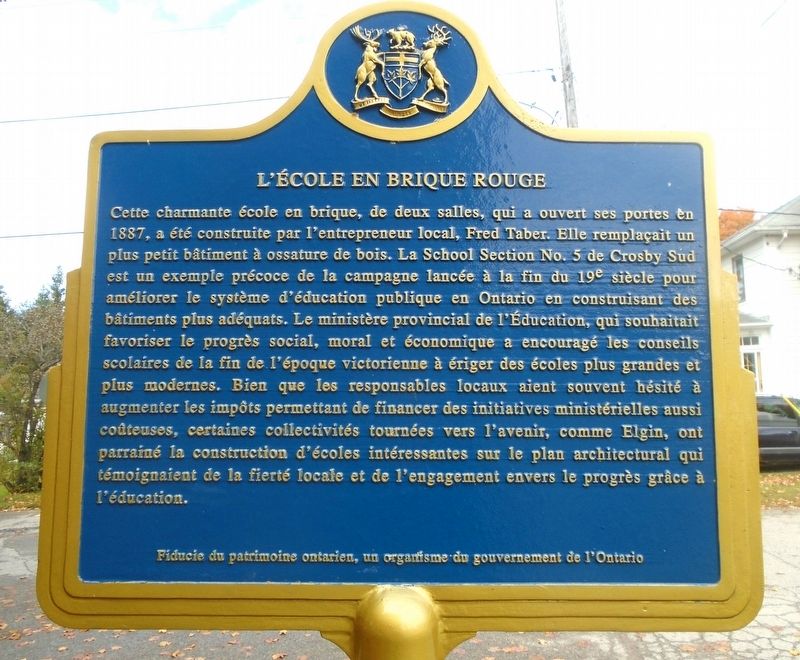
Opened in 1887, this charming two-room brick school, built by local contractor
Fred Taber, replaced a smaller wood-frame building. School Section No. 5 in
South Crosby is a very early example of the late 19th century campaign . . . — — Map (db m207541) HM
Built about 1831-32, and designed in the late phase of the Neo-Classic style, this structure is among the best of its type remaining in Ontario. Constructed as a dwelling for John McDonald, a local landowner, merchant, postmaster and later a member . . . — — Map (db m83532) HM
Built as a house in the 1850s, this sturdy stone building was altered in 1877 by John Dumbrille, when he relocated his general store from across the street in front of his residence "Sprucelawn". In 1879 he was appointed Maitland's postmaster and . . . — — Map (db m89979) HM
Construction of Homewood was begun in 1800 by Dr. Solomon Jones, a prominent Loyalist, local officeholder and early resident of this region. With its balanced five-bay façade, centre hallway plan and classical detailing, it reflects the influence of . . . — — Map (db m205243) HM
The heritage character and integrity
of this property are protected by a
legal agreement between the owner
and the Ontario Heritage Foundation . . . — — Map (db m142264) HM
The front portion of this structure one of the earliest surviving military buildings in Ontario, was constructed as a residence about 1810 by Colonel Edward Jessup, the founder of Prescott. Following the outbreak of the War of 1812, the stone house . . . — — Map (db m86950) HM
Completed in 1884, restored in 1969 as Aeolian Town Hall, served as a centre for political and social life in London East until 1947. — — Map (db m18963) HM
This streetscape includes several of London's earliest buildings and provides a capsule view of the appearance of mid-19th century Ontario cities. These buildings, the earliest of which was begun in 1835, include residential, industrial and . . . — — Map (db m18972) HM
Adam Fralick, a descendent of a United Empire Loyalist family, watched as the tourist industry grew around the War of 1812 battlefield at Lundy’s Lane. In 1836, he purchased this property and built the Battle Ground Hotel. Later, in 1850, Fralick . . . — — Map (db m139940) HM
200 yards north east of this point stood
"Stamford Cottage" later known as
"Stamford Park" the home of
Sir Peregrine Maitland, Lieutenant Governor
of Upper Canada from 1818 to 1828.
The property was purchased in 1822 . . . — — Map (db m75856) HM
John Latshaw architect
Offices for Stamford Township
and
the City of Niagara Falls
1874-1970
and the
Lundy's Lane Historical Museum
since 1970
Commemorated by
the
Lundy's Lane Historical Society
on the
centenary of this . . . — — Map (db m196311) HM
Opened in 1906 to supply the Toronto market, this generating station was the first wholly Canadian-owned hydro-electric facility at Niagara Falls. Engineers adapted advanced European and American technologies to a difficult site in a bold and . . . — — Map (db m79737) HM
[Text on Marker]:
Immediately after the War of 1812, a new wooden storehouse was built on this site. It was converted into barracks for British troops during the border troubles of 1838. The building remained in use until the 20th . . . — — Map (db m49478) HM
This building, the first in Ontario to be constructed for use solely as an historical museum, was begun in 1906 and completed the following year. Its erection was due largely to the dedicated efforts of Miss Janet Carnochan, founder, and for thirty . . . — — Map (db m75861) HM
Acquired by the Ontario Heritage Foundation in 1969, the Niagara Apothecary is a fine example of a Confederation era commercial establishment and pharmacy. Although the building probably dates to the 1820's. It was extensively renovated in 1866 when . . . — — Map (db m24609) HM
(Left side is in English)
In 1778, Loyalist refugees began crossing from Fort Niagara to settle the west bank of the Niagara River. A town was laid out in a grid pattern of four-acre blocks and grew quickly, gaining prominence as the first . . . — — Map (db m24585) HM
This hall served as a Municipal Building for 118 years for the former Township of Humberstone.
The original hall with its local Welland Canal stone and Palladian windows was designed by architect John Latshaw in 1852.
The rear Lock-up wing for . . . — — Map (db m196261) HM
[Top plaque]
City of Thorold
The Old Firehall
1878
Designated under
the Ontario Heritage Act
[Bottom plaque]
Thorold's Old Firehall
1878
Designed by John Latshaw in red and yellow brick, this . . . — — Map (db m196305) HM
One of the finest public buildings in Canada, this imposing structure was built as an expression of civic pride and confidence in the future. It was begun in 1856 and opened by the Prince of Wales four years later. Designed by the renowned . . . — — Map (db m90084) HM
This building, designed by the architect Kivas Tully in a Victorian version of the Palladian style, is representative of the finer public buildings of mid-nineteenth century Canada. One of the most impressive town halls in Ontario, it reflects the . . . — — Map (db m90086) HM
English: This house was constructed in 1898 for Alphonse Rochon, who, with his father Flavien, was responsible for much of the wood carving on the interior of Notre Dame Cathedral. Rochon applied his skills to his own house, and . . . — — Map (db m150712) HM
English: Built by Thomas Brûlé, a blacksmith, noted for his involvement in Bytown’s “Stoney Monday” riot of 1849. Français: Construite par Thomas Brûlé, forgeron devenu célèbre à la suite de sa participation à . . . — — Map (db m149194) HM
Built as a grocery store by Thomas Coffey, Sr., this building was the Grand Central Hotel from 1889 to 1907, and a Salvation Army hostel from 1908 to 1949.
Designated Heritage Property
—————————
Construit au départ comme l'épicerie de . . . — — Map (db m63693) HM
Pictured in 1870, Dickinson House was originally built by American born Moss Kent Dickinson for his business and was modelled after Abraham Lincoln's house in Springfield, Illinois. The house ultimately became home to the Dickinson, . . . — — Map (db m110309) HM
An excellent example of a country house in the British classical tradition, this handsomely proportioned limestone building is one of the earliest residences in the Ottawa area and a reminder of the estates which once lined Richmond Road. Built by . . . — — Map (db m115182) HM
This elegant residence and its walled garden are a rare and well-preserved example of a country estate in early 19th-century Canada. Built from 1831 to 1834 for William Thomson, a prosperous farmer, its centrepiece is this finely crafted home in the . . . — — Map (db m115185) HM
The Woodstock armoury was built
in 1905 and was occupied by the
Oxford Rifles until October, 1954.
The 22nd Battalion Volunteer
Militia Rifles- the Oxford Rifles,
headquartered Woodstock, was
organized August 1st, 1863, with
companies in . . . — — Map (db m231239) HM
(English side:)
This court house building, together with the adjacent jail and registry office, served as the judicial and administrative centre for the County of Peel for more than a century. Its prominent location on a rise of land and . . . — — Map (db m115227) HM
In April of 1899 a delegation of concerned citizens approached St. Marys Town Council to request a plebiscite for the purpose of installing a municipal water system. Council granted their request and prepared the necessary by-law. Three months later . . . — — Map (db m198287) HM
In 1891, after the frame town hall on this site burned, Town Council ran a competition for the design of the new town hall. Toronto architect G.W. Gouinlock's plans for a Richardson Romanesque building were chosen.
The structure, of St. Marys . . . — — Map (db m198284) HM
In 1816 the Ottawa district was established and the Courts of Quarter Session, which at that time possessed local administrative as well as judicial authority, were held in the Township of Longueuil. In 1824 Jacob Marston donated a plot of land in . . . — — Map (db m103967) HM
Built in 19089 for Alexander Chatelain, a respected insurance broker and businessman, this red brick house with a turret was designed to mirror large English residences.
In 1940, it became the property of his daughter Gabrielle, married to Eusebe . . . — — Map (db m202299) HM
Constructed in 1909 as the Industrial Development and Publicity Bureau by the City of Port Arthur, as a special building for the purpose of furthering the industrial and general development of the city. Designed by H. Russell Halton of Fort . . . — — Map (db m243800) HM
This tourist kiosk was erected in 1909 to promote Port Arthur's social and economic merits to visitors and investors. Its eye-catching architecture and strategic location reflect civic boosterism and the city's rivalry with nearby Fort William . . . — — Map (db m107068) HM
The city of Port Arthur’s first Methodist Church was built on this site in 1871. The present church, built in 1905 as the “Methodist Church,” was renamed “Trinity Methodist Church” in 1908. Architects were Langly-Langly from Toronto who designed . . . — — Map (db m244202) HM
To commemorate the official opening of the Municipal Offices of the Corporation of the Town of Kirkland Lake June 26, 1980 by the Chief Administrative Officer D. B. McDougall Mayor G. L. Hamilton Councillors M. . . . — — Map (db m244796) HM
City Hall was designed in 1887 by E. J. Lennox to fit this central site at the head of Bay Street. In one structure, these municipal buildings combined a City Hall, in the east portion, and Court-house in the west. The building, constructed mostly . . . — — Map (db m196173) HM
[English] Built between 1889 and 1899, this impressive Richardsonian Romanesque structure by local architect E. J. Lennox was the solution to the need of both the city of Toronto and York County for new quarters. Its superb downtown . . . — — Map (db m199998) HM
[English] The King Edward Hotel was built by George Gooderham's Toronto Hotel Company to meet the demand in the rising metropolis for a grand hotel. When it opened in 1903, the hotel, affectionately known as the “King Eddy”, was . . . — — Map (db m208383) HM
[English] Department stores revolutionized shopping in the late nineteenth century by offering selection, low prices and money-back guarantees. In 1895, Robert Simpson commissioned architect Edmund Burke to design his new department . . . — — Map (db m208195) HM
English:
Built on the site of the Queen's Hotel by the Canadian Pacific Railway in 1928-29, the Royal York Hotel was part of its coast-to-coast chain of grand hotels. The skyscraper hotel, designed by Montreal architects Ross and . . . — — Map (db m83660) HM
Now landlocked on Fleet Street, this lighthouse once stood on the Queen's Wharf. The wharf - originally known as New Pier - was built in 1833 to stimulate commercial activity in the west part of the harbour.
This lighthouse, constructed in 1861 . . . — — Map (db m211603) HM
[English] Campbell was born near Caithness, Scotland. He fought with the British forces during the American Revolution and was taken prisoner at Yorktown in 1781. Three years later he was practising law in Nova Scotia where, in 1799, he was . . . — — Map (db m208175) HM
[English] Originally all post offices in Upper Canada were owned by the postmasters in charge, who were imperial appointments. This building was constructed for postmaster James Scott Howard during 1833-1835 and functioned as the . . . — — Map (db m208172) HM
Sir John A. Macdonald, Canada's first prime minister, purchased this house in 1876 and lived here 1876-78. It was built in 1872 in the French Second Empire style by Nathaniel Dickey, a Toronto iron founder. Macdonald owned the property until 1886 . . . — — Map (db m36978) HM
In 1829-32 the Law Society of Upper Canada erected the east wing of this imposing building. Named after William Osgoode, the province's first chief justice, the Regency structure housed law courts and judicial offices, and provided accommodation for . . . — — Map (db m196169) HM
This attractive public building was designed and built in 1857-8 by H.B. Sinclair, a local resident, as a "Town Hall and Market House". Galt had become an incorporated town on January 1, 1857, and the first mayor, Morris C. Lutz, was elected by the . . . — — Map (db m196195) HM
[Top plaque]
City of Kitchener
Heritage Landmark
1939
[Bottom plaque]
A.D. 1852 – 1938
This new registry office
building was erected in
the years A.D. 1938-1939
to replace the old brick
building constructed by
the . . . — — Map (db m196192) HM
The south eastern unit built 1853 by John Catchpole, tinsmith. Probably the first stone structure on Norfolk Street. John Howard added the larger corner section in 1864. Imposing mid 19th century styled masonry. Designated as a Building of . . . — — Map (db m208699) HM
[English] Many Canadian cities erected well-designed municipal buildings during the mid-19th century railway boom. Guelph City Hall, one of the best of this group, symbolized the city’s confidence in its future. Designed by Toronto . . . — — Map (db m208693) HM
This photo shows the original Town Hall and Market House designed by architect William Thomas. The building opened in 1857. The tower bell was rung daily at 7 a.m., 12 noon and 6 p.m., and during fires, funerals and special events. The central . . . — — Map (db m208695) HM
In 1832 Canada Company Lot 108 was purchased by J.C.W. Daly, an agent of the Company. Later used as a merchant shop by Elizabeth Worsley, it was purchased from her estate in 1855 by the Emslie brothers, stone masons, builders, and owners of a . . . — — Map (db m208697) HM
172 entries matched your criteria. Entries 101 through 172 are listed above. ⊲ Previous 100