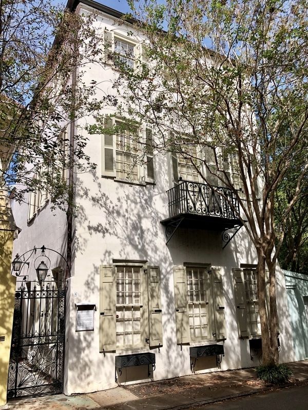
On Tradd Street east of Bedons Alley, on the left when traveling east.
This three-story stuccoed brick house was built sometime between 1778, the year of the great fire, and 1788. It stands on part of Lot 7 of the “Grand Modell” within the walled city of Charles Town and was the birthplace of Robert Tradd, who, . . . — — Map (db m187613) HM
On Meeting Street south of Broad Street, on the right when traveling south.
U.S. Courthouse and Post Office (side 1)
This Renaissance Revival building, opened in 1896, is notable for its association with U.S. District Judge J. Waties Waring (1880-1968). Waring, a Charleston native who served here 1942 to 1952, . . . — — Map (db m133659) HM
On Saint Andrews Boulevard at 5th Avenue, on the right when traveling north on Saint Andrews Boulevard.
The town of Maryville, chartered in 1886, included the site of the original English settlement in S.C. and the plantation owned by the Lords Proprietors 1670-99. When the old plantation was subdivided into lots and sold to local blacks in the 1880s, . . . — — Map (db m16283) HM
On Fishburne Street, on the left when traveling east.
Founded as a private school for elementary students in 1894 by Rev. John Dart at the corner of Bogard and Krake Streets, Charleston Normal and Industrial School was approved to become a public school for "colored" children in 1910 and opened at the . . . — — Map (db m39754) HM
On Fishburne Street, on the right when traveling west.
(Front text)
This school, founded in 1910, was the first public high school for African-Americans in Charleston. It succeeded the Charleston Normal & Industrial School, a private school at Bogard & Kracke Streets, which had been founded . . . — — Map (db m39621) HM
On Fort Johnson Road, on the right when traveling north.
The George D. Grice
Marine Biological
Laboratory
In grateful appreciation
of his forsight and tireless
efforts which resulted in the
establishment of this center
for the study of and research
in Marine Biology, the . . . — — Map (db m58758) HM
On Chisolm Road (State Highway 10-54) at Belvedere Road (State Highway 10-1493), on the right when traveling south on Chisolm Road.
In 1898 Charleston County School District No. 11 bought this land from J. S. Hart and built a public school on the site soon after. School closed in the early 1920s. — — Map (db m37020) HM
On West Broad Street just north of West Carolina Avenue, on the right when traveling south.
Lincolnville School
Lincolnville School, the first public school for black students in this community, stood here from 1924 to 1953. Built at a cost of $6,100, it was one of more than 5000 schools in the South funded in part by the Julius . . . — — Map (db m223811) HM
On Pinckney Street at Rutledge Court on Pinckney Street.
Side A Archibald Hamilton Rutledge (1883-1973), educator, man of letters, and the first poet laureate of S.C., was born at this site, in a house known to the Rutledge family as "Summer Place." Rutledge, who grew up here and at Hampton . . . — — Map (db m39040) HM
Near Long Point Road, 0.6 miles west of U.S. 17, on the left when traveling west.
Charles Pinckney, like most other members of the plantation elite, was educated and trained for public service. In 1779, at the age of 21, he was elected to represent Christ Church Parish in the General Assembly of South Carolina. Over the next . . . — — Map (db m224187) HM
On Coleman Avenue (U.S. 17), on the right when traveling east.
(Front): The Moultrie Schools were named in honor of General William Moultrie, the highest ranking S.C. officer during the Revolutionary War and hero of the 1776 Battle of Fort Sullivan, which was renamed Fort Moultrie. He fought in the S.C. . . . — — Map (db m31883) HM
Jasper Green
Jasper Green, a grassy field, became part of Moultrie High School’s campus and was named for Sergeant William Jasper. Jasper Green was home to the Moultrie High School Generals, now the Moultrie Middle School Patriots. The Green . . . — — Map (db m37811) HM
Side A In 1809, the SC General Assembly incorporated Mount Pleasant Academy to educate the children of Christ Church Parish. Funded by a legacy and a lottery, a schoolhouse was built, but its site is uncertain. At times, classes were held . . . — — Map (db m38042) HM
Side A At this site in 1881, Abby Munro, a Quaker from Philadelphia, established a home for orphans, neglected, and destitute children. Funds to purchase and operate the home were solicited locally and from friends in the North. It was . . . — — Map (db m38045) HM
On Azalea Drive (State Highway 10-894), on the left when traveling west.
(Front text) Since 1937 this has been the campus of the Jenkins Orphanage, established in Charleston in 1891 by Rev. Daniel Joseph Jenkins (1862-1937). Jenkins, a Baptist minister, founded this orphanage for African American children with . . . — — Map (db m39336) HM
Near Middle Street at Osceola Avenue, on the left when traveling east.
1902-1947
This one-story brick structure was built in 1902 by the US Army Corps of Engineers for the storage of torpedoes and equipment used to defend Charleston Harbor by the United States Army.
1950-1953
After the US Army left in 1947, this . . . — — Map (db m225171) HM
On North Limestone Street (State Highway 150), on the right when traveling north.
This Classical Revival building, built in 1913-14 and designed by Arthur W. Hamby, was one of 14 public libraries built in S.C. between 1903 and 1916 with funding from Andrew Carnegie and Carnegie Foundation. A 1938 addition compatible to the . . . — — Map (db m7307) HM
Near College Drive south of Griffith Street when traveling south.
In 1845, Dr. Thomas Curtis was able to fulfill his dream of establishing an institution of higher learning for young women by purchasing a magnificent building at Limestone Springs, which had been constructed in the 1830s as a resort hotel. The . . . — — Map (db m209839) HM
On East Buford Street just west of Laurel Street, on the right when traveling west.
Dunton Chapel Methodist Church can trace its origins to 1870 when Rev. J.R. Rosemond began preaching in the home of Milton Hardy. The church was built c. 1878, but has undergone many renovations, including being brick veneered in 1937. Originally . . . — — Map (db m196183) HM
On Old Georgia Highway (U.S. 29) near Willis Street.
Granard Graded and High School
This is the original location of Granard Graded and High School, also known as Granard Street School. It was built here between 1905 and 1914 and included the first black high school in Gaffney. The first high . . . — — Map (db m23967) HM
The Seven Branches Of Learning
Quadrivium
The higher division of the seven liberal arts in the Middle Ages, composed of geometry, astronomy, arithmetic, and music
Trivium
The lower division of the seven liberal arts . . . — — Map (db m7253) HM
On Griffith Street at College Drive, on the left when traveling west on Griffith Street.
Founded in 1845 as the Limestone Springs Female High School by Dr. Thomas Curtis and his son Dr. William Curtis, distinguished Baptist clergymen. The school thrived until falling on hard times during the Civil War and Reconstruction. In 1881 the . . . — — Map (db m44487) HM
On East Oneal Street, on the right when traveling west.
Used as early as the American Revolution, this site became a “Summer Watering Place” in 1835. Low country aristocrats such as Governor David Johnson were attracted here by the climate and therapeutic waters. A post office was here . . . — — Map (db m9967) HM
[East Face]:
Erected
to the Memory
of
The Reverend
Thomas Curtis, D.D.
by his affectionate
and
devoted pupils.
[West Face]:
He was born
May 10, 1797 in the town
of Wisbfach England.
And was lost . . . — — Map (db m7281) HM
On West End Road (State Highway 72/121) 0.4 miles east of Sandy River Road (State Road 42), on the left when traveling east.
St. Paul Baptist Church at HalsellvilleThis congregation, originally known as St. Paul Colored Baptist Church, was formally organized by 1884 on nearby Goings Road. The church moved to this location in 1901. Members acquired the land for . . . — — Map (db m246066) HM
On 2nd Street (U.S. 1) 0.1 miles south of Powe Street (U.S. 1), on the right when traveling north.
Organized in 1881, this Negro Presbyterian (USA) school was founded by the Rev. J.P. Crawford with support from Mrs. C.E. Coulter from whom it received its name. The Rev. G.W. Long was academy president from 1908 until 1943, and Coulter offered . . . — — Map (db m18197) HM
On West Main Street (Business State Highway 9) at Academy Street, on the left when traveling west on West Main Street.
(front)
The building that stands here once served as the Chesterfield Academy. The first Chesterfield Academy building was located nearer to downtown. Local tradition holds that the Union 20th Corps burned the school along with other . . . — — Map (db m113789) HM
On West Main Street (Business State Highway 9) at Crescent Drive, on the right when traveling west on West Main Street.
Chesterfield High School, which stood here from 1908 to 1992, was the successor to Chesterfield Academy, an antebellum school burned by Federal troops in 1865. A new academy, built in 1889, later became Chesterfield School. By 1907 it has three . . . — — Map (db m113790) HM
On North Brooks Street (U.S. 301/521) near Oak Street, on the left when traveling north.
Hanna Levi Memorial Library
The Hannah Levi Memorial Library, built
in 1909-1910, grew out of a library fund
begun in 1905 by the children of Moses
and Hannah Levi, along with proceeds
from the sale of Moses Levi Memorial
Institute. A . . . — — Map (db m24625) HM
Near Old Georgetown Road west of North Brooks Street (U.S. 301), on the left when traveling west.
(side 1)
The Manning Collegiate Institute, the town’s first public school opened here in early 1890. The two-story frame school with a bell tower, built in 1889-1890, was called “one of the most handsome and imposing” buildings in . . . — — Map (db m224596) HM
On Weinberg Street north of West Boyce Street, on the left when traveling north.
(side 1)
Manning Training School has origins in the early 20th century with the Slater Fund helped finance Clarendon County Training School. This facility provided both education for black students and advanced training for African . . . — — Map (db m224599) HM
On US 301 & US 521, on the left when traveling north.
On the night of November 7, 1780, Lt. Colonel Banastre Tarleton and his Green Dragoons—together with Harrison’s Provincials, a large unit of Tories from the area between the upper Santee and Wateree Rivers—camped at the plantation of the late . . . — — Map (db m51985) HM
On L and H Pearson Road, 0.1 miles south of Costello Road, on the right when traveling south.
(Side 1)
Pearson Family Homesite
This farm was home to the family of Levi Pearson (1894-1970), who with his brother, Hammett Pearson, joined other African American parents in Davis Station and Jordan protesting Clarendon Co. . . . — — Map (db m199865) HM
On US 301 at Joe Marie Road, on the right when traveling south on US 301.
Black institute built soon after school district purchased the land in 1933. School closed in 1953 with 5 teachers/ 159 students. Now a community center. — — Map (db m24158) HM
On Patriot Road (State Highway 14-410) at Wyboo Road on Patriot Road.
In March 1781, Lord Francis Hastings Rawdon, the British commanding officer in Charleston, designed a two-pronged assault against the forces of General Francis Marion. From Camden, Col. Welbore Ellis Doyle and the Volunteers of Ireland moved east . . . — — Map (db m51986) HM
On Larry King Jr. Drive near 4th Street, on the left when traveling east.
"Together let us sweetly live" Distinguished Followers of Justice Briggs VS. Elliott Rev. Joseph A. Delaine; Mr. Hammett Pearson; Mr. Levi Pearson; Mr. Harry Briggs; Mr. Joseph Lemon; Pioneers in the School Desegregation Case; Historical plaintiffs . . . — — Map (db m52315) HM
On Church Street (U.S. 301) near Burgess Street, on the right when traveling north.
This is the childhood home of Anne Custis Burgess, who was born in 1874 in Mayersville. After receiving a diploma from Converse College, she taught music at Summerton, Williamston, and Winthrop College. At the time of her death in 1910 she was . . . — — Map (db m24528) HM
On Delaiane Street at Hill Street, on the left when traveling west on Delaiane Street.
(Side 1)
Briggs Family House
On November 11, 1949, local African American families came to this house to sign a petition demanding equal resources in Summerton's racially segregated schools. Believing the homes isolated location . . . — — Map (db m199859) HM
On 4th Street at Larry King Highway, on the left when traveling north on 4th Street.
Mr. Harry and Eliza Briggs, a family of strong faith, were one of the first families to sign the petition. Meetings were held in their homes as well as St Mark AME, and Liberty Hill AME. These gatherings were held in secrecy to find twenty parents . . . — — Map (db m233255) HM
On 4th Street at Larry King Highway, on the left when traveling north on 4th Street.
Mr. Levi Pearson, Sr. was a farmer and a humble man of strong faith and integrity, who believed in fairness. He initiated the fight to improve educational opportunities in Clarendon County in 1947 by asking Clarendon School District 26 to provide . . . — — Map (db m233256) HM
On 4th Street at Larry King Highway, on the left when traveling north on 4th Street.
Described as courageous, fearless, confident, faithful, committed, humble and a man of integrity. The Rev. Joseph Armstrong De Laine was a pastor, principal and a great community leader who was the primary impetus behind the Clarendon County . . . — — Map (db m233254) HM
On 4th Street at Larry King Highway, on the left when traveling north on 4th Street.
(Side 1)
Scott’s Branch School
Previously located at Taw Caw Baptist Church outside Summerton and at a site on 1st St., Scott's Branch School moved here 1937-38. The first school at this site was a white, ten room, frame building . . . — — Map (db m199855) HM
On 1st Street at Larry King Highway, on the right when traveling north on 1st Street.
(Side 1)
In 1885, sixty-five former members of Liberty Hill A.M.E. Church. (3 mi. SE) organized this congregation to have a church closer to their homes. They first met in a small frame building that fronted Main Street. In 1905, members . . . — — Map (db m199851) HM
On Bells Highway (State Highway 64) near Lodge Highway (State Highway 217), on the right when traveling west.
In Memory of
Bonnie E. Cone
June 22, 1907 ~ March 8, 2003
A native of Lodge
and
a tireless visionary
whose unwavering belief
in
the love of God
the kindness of people
and the power of education
led
to the founding of . . . — — Map (db m32935) HM
On Hampton Street (State Highway 63) near South Miller Street, on the right when traveling east.
Incorporated December 17, 1834, Walterborough Academy was the forerunner of the present city school system. Its trustees were Malachi Ford, John G. Godfrey, John D. Edwards, David Campbell, and Archibald Campbell. The Reverend John B. Van Dyke . . . — — Map (db m8665) HM
On Wichman Street, on the right when traveling west.
Marked geographic center of town
First location on present site of
St. Jude's Episcopal Church
Moved in 1845 to land given by
Richard B. Bedon
Now used by the
Colleton County Historical Society — — Map (db m7114) HM
On Sixth Street close to Cooley Street, on the left when traveling south.
Butler School, located on this site since 1921, was the second public school to serve Hartsville's black community and operated for over sixty years. Known as the Darlington Co. Training School until 1939, it was renamed for Rev. Henry H. Butler, . . . — — Map (db m38137) HM
On E. Home Ave., on the right when traveling east.
Known world-wide for developing new varieties and for perfecting superior strains of agricultural crops (including cotton), Coker, for years was pres. Pedigreed Seed Co., chartered 1918. He was intendant (mayor) of Hartsville 1900-1901; member . . . — — Map (db m38131) HM
On S 6th Street near Marion Avenue, on the right when traveling south.
Hartsville Graded School The first public school for the black children of Hartsville and vicinity operated on this site from about 1900 to 1921. It was renamed Darlington County Training School in 1918. A new school was built on 6th St. south . . . — — Map (db m60604) HM
James L. Coker (1837-1918) came here from Society Hill ca. 1858 as a planter. While serving in the Civil War as a captain in Co. E, 6th Regiment SC Volunteers, he was seriously wounded. Promoted to major in 1864, he was a member of the SC House . . . — — Map (db m38129) HM
This house was the residence of Captain Thomas Edwards Hart, who settled on these lands in 1817, and for whom Hartsville was named. He was a Justice of the Peace, Chairman of the Board of Free Schools, planter, merchant, and was appointed first . . . — — Map (db m38124) HM
On E. Home Ave., on the right when traveling east.
Welsh Neck High School The Welsh Neck Baptist Association initiated this institution as a coeducational boarding school. It opened Sept. 17, 1894, through the generosity of Maj. James Lide Coker, Civil War veteran, local industrialist, and the . . . — — Map (db m239171) HM
On South Main Street (U.S. 401) at Pressley Avenue, on the right when traveling north on South Main Street.
This house, built ca. 1832, was the home of Caleb Coker (1802-1869) and the birthplace of his son Maj. James Lide Coker (1837-1918), Confederate officer, industrialist, and founder of Coker College. Caleb Coker, a merchant, was also a director of . . . — — Map (db m38165) HM
On Society Hill Rd. at Lumber Road, on the left when traveling south on Society Hill Rd..
March 8, 1776-November 17, 1830 Statesman, educator, pioneer manufacturer, scientific farmer, State Senator, Congressman, Governor 1814-1816, Brigadier General in the War of 1812. His residence, "Center Hall," was ½ mile east. His grave is in . . . — — Map (db m38142) HM
On South Main Street, on the right when traveling north.
[Front] Henry C. Burn (1839-1912), state representative and Darlington County public servant, lived here from 1882 until his death. Burn, born in Chesterfield District, was educated at St. David’s Academy in Society Hill, then at Furman . . . — — Map (db m38166) HM
On Main Street (U.S. 401) 0.1 miles north of Carrigan Avenue, on the right when traveling north.
Lawrence Faulkner
Born c.1840 and a resident of Darlington County by 1871, Lawrence Faulkner was a black school teacher, later merchant, and Society Hill's postmaster from 1877 to 1889. A trustee of nearby Union Baptist Church, Faulkner died in . . . — — Map (db m38159) HM
On S. Main St. (U.S. 401) at Pressley Avenue, on the left when traveling north on S. Main St..
[Front] On June 5, 1822, twelve men paid $20 each to purchase books for a library. These men were J. J. Evans; David and Elias Gregg; D. R. W., J. K. and T. E. McIver; Thomas Smith; Alexander Sparks; D. R. and J. N. Williams; J. F. Wilson; . . . — — Map (db m38160) HM
On S. Main St. (U.S. 401) close to St. Davids Street, on the left when traveling north.
The St. David's Society, organized in 1777 and chartered in 1778, built the first public academy in St. David's Parish ¾ mile northeast in 1786. Alexander McIntosh, George Hicks, Abel Kolb, William Pegues, and Thomas Evans were early officers. The . . . — — Map (db m38143) HM
On Railroad Avenue north of Main Street, on the left when traveling north.
First settler, first merchant, first mayor, first postmaster, chairman of first school board. Post Office in his store—20 feet north of this point. This memorial erected in 1990 by his family. — — Map (db m16821) HM
On Kentyre Road at McNair Drive, on the right when traveling east on Kentyre Road.
Kentyre Presbyterian Church traces its origins to meetings held in the home of Peggy Edwards in the 1860s. The congregation was officially organized in 1871 and was named after the Kintyre region of Scotland. The first permanent sanctuary, which . . . — — Map (db m224325) HM
On West Main Street near South Marion Street, on the right when traveling west.
Andrew Carnegie was born in Scotland in 1835 as the Industrial Revolution was sweeping across Great Britian. Seeking a better life his family arrived in Pittsburg, Pennsylvania while Andrew was a small child. From a bobbin boy in a cotton mill . . . — — Map (db m45146) HM
On Centerville Road, on the right when traveling north.
(side 1)
Pine Hill A.M.E. Church
This church, founded in 1876, was in Marion County before Dillon County was created in 1910. At first on S.C. Hwy. 34, the church acquired this site in 1891 when Alfred Franklin Page (1863-1929) and . . . — — Map (db m48927) HM
Herod W. Williams was concerned about the education of his children as were many parents in Latta. With the help of farm hands Allen constructed a one room school on his property. When the school opened in 1877 there were fifteen students who paid . . . — — Map (db m46692) HM
On Ridge Street at Raysor Street, on the right when traveling north on Ridge Street.
(front)
St. George Public High School
St. George High School was built in 1927 on the corner of Raysor and Ridge Sts. In 1936 the school district received a W.P.A. grant to build a new gymnasium. The building continued as a high . . . — — Map (db m103405) HM
On West 1st N Street at North Cedar Street, on the right when traveling west on West 1st N Street.
Alston Graded School Alston Graded School, one of the first African-American schools founded in Dorchester County, stood here from 1910 to 1954. Named for its founder, Dr. J.H. Alston, it included grades 1-11 until 1949 and 1-12 afterwards. . . . — — Map (db m27766) HM
Near South Main Street (Alternate U.S. 17) at South Hampton Street, on the right when traveling north.
The Town of Summerville and the lives of Coach McKissick and Joan, his wife, are forever linked in history. Coach McKissick served as the Head Coach for the Summerville Green Wave football program for 63 seasons: 1952 — 2015. Joan, his loyal wife, . . . — — Map (db m225000) HM
A small brick building once stood here housing the Dorchester Free School. The school offered free education to omly a few poor students. All others paid tuition. Opportunities for white children to learn outside the home or shop was limited. Black . . . — — Map (db m22659) HM
On Salisbury Drive at Linwood Lane, on the right when traveling south on Salisbury Drive.
(side 1)
The Pine Forest Inn opened in 1892. It was owned and managed by F.W. and George Wagener. The 60-acre resort and health spa contained 150 steam-heated sleeping apartments. The dining room could hold 250 people. The Inn had a . . . — — Map (db m224490) HM
On Tea Farm Road at West Johnston Street, on the left when traveling north on Tea Farm Road.
(side 1)
In 1880 the U.S. government leased 200 acres of the former Newington Plantation from Henry Middleton for tea production. In 1888, Dr. Charles Shepard, a professor at the Medical College of S.C., used plants from the federal . . . — — Map (db m224494) HM
Near South Main Street (Alternate U.S. 17) near Joyce Lane, on the left when traveling south.
(side 1)
The 2-story brick building SW of here was built in 1924-25 to house Summerville High School (SHS). The school originally included the north hall and central auditorium, with the west and east wings being added later. In . . . — — Map (db m224488) HM
On Central Avenue just east of West 3rd Street, on the right when traveling east.
In 1897 a group of young Summerville women formed a Chautauqua Reading Circle; from this modest beginning the Timrod Library developed. The women donated books from their reading circle to be the nucleus of a membership library chartered April 23, . . . — — Map (db m224637) HM
On Central Avenue at West 3rd Street, on the right when traveling east on Central Avenue.
(side 1)
In 1897, the Timrod Library was organized by 19 women as a Chautauqua Reading Circle. It was chartered in 1908 as the Timrod Literary and Library Association. In 1915, Timrod’s current home was erected on land donated by the . . . — — Map (db m224484) HM
On Church Street, on the right when traveling north.
First Baptist Church
Founded in 1823 as Edgefield Baptist Church, with Basil Manly, Sr., Pastor, Matthew Mims, Clerk, and Arthur Simkins, Moderator, this church led in the establishment here in 1826 of Furman Academy and Theological . . . — — Map (db m12671) HM
Native of Edgefield Born 1902
County Supt. of Education 1929-1933
State Senator 1933-1938
Circuit Judge 1938-1946
U.S. Army - World War II 1942-1946
Governor of South Carolina 1947-1951
United States Senate 1954-
Chairman - Senate . . . — — Map (db m12653) HM
On Columbia Road, on the right when traveling west.
[Front]:
J. Strom Thurmond, by mid-1997 the longest-serving U.S. Senator in history, was born here to J. William and Gertrude Strom Thurmond Dec. 5, 1902. educated at Clemson College, he taught high school 1923-29, was county . . . — — Map (db m12408) HM
On Waterworkd Road, on the left when traveling south.
The longest serving and oldest Senator in American history, he began his public service as Edgefield County Superintendent of Education in 1929. A decorated soldier and circuit court judge, he was elected in the U.S. Senate as a write in candidate . . . — — Map (db m12933) HM
On Church Street, on the right when traveling north.
1826
Original site of Furman Academy and Theological Institution.
Marked by the Old 96 District Chapter, Daughters of the American Revolution.
1926 — — Map (db m12702) HM
W.W. Adams, a prosperous Edgefield merchant and longtime Edgefield mayor, built this building in 1907 as a warehouse to serve the needs of cotton founders. The Edgefield Chronicle noted in that year: "The great brick warehouse of Mr. W.W. . . . — — Map (db m12939) HM
On Norris Street, on the right when traveling south.
A member of the famous Butler families of the Edgefield District, Butler promoted education & the building of railroads during his term as Governor. He commanded the Palmetto Regiment during the war with Mexico where he was fatally wounded. — — Map (db m81697) HM
Religion has played an important part in the lives of the people of Edgefield County. In the 1760's, the great evangelist Daniel Marshall, came to this area and established Big Stevens Creek and Horn's Creek Churches. In 1826 Edgefield Baptists, . . . — — Map (db m12594) HM
On Church Street, on the right when traveling north.
Village Academy
Organized in 1811, the Edgefield Village Academy was located for many years on this site acquired from Col. Eldred Simkins in 1825. The South Carolina Coeducational Institute was located here from 1903-1913. During . . . — — Map (db m12700) HM
On Lee St. (State Highway 121) close to Academy Street, on the right when traveling north.
Johnston Schools
Johnston’s first school opened on this site in 1873. The Male and Female Academy was a boarding school, with Rev. Luther Broaddus as its first principal. Alternately a private and public school during its early history, it was . . . — — Map (db m28226) HM
On Steeple Road, 0.3 miles west of Old Plank Road, on the right when traveling west.
(Front)
Mt. Pleasant Baptist Church was organized in 1869 when the African American members of Philippi Baptist Church requested permission to form an independent congregation. Fifty-two
African American members, most of them recently . . . — — Map (db m238684) HM
Erected in honor of the founder of Bettis Academy
Rev. Alexander Bettis
Born August 4, 1836 - Died May 13, 1895
He was a born leader and a friend of humanity.
Gone but not forgotten.
----------
Erected by Mt. Canaan Association 1942 . . . — — Map (db m12850) HM
Bettis Academy and Junior College, a private school for African Americans, was founded in 1881 by Rev. Alexander Bettis, a former slave who was taught to read by his owner's wife, but was never taught to write. A Baptist Minister, he established . . . — — Map (db m12846) HM
On Bettis Academy Road, on the left when traveling south.
Established as a result of the inspiration and efforts of the Reverend Alexander Bettis, this coeducational institution was incorporated in 1889 and provided elementary, high school, and junior college training for blacks. A.W. Nicholson . . . — — Map (db m12795) HM
[Front]:
This church, founded in 1868, was one of the first black Baptist churches in this area. Alexander Bettis (1836-1895), a former slave, established this church with the assistance of three white ministers after the local Baptist . . . — — Map (db m12800) HM
On State Highway 215 at Coleman Road, on the left when traveling south on State Highway 215.
Around 1840 an academy was established at this site by John Feaster, a noted landowner of this area, for the education of female and male students. By 1842, both academy building and a boarding house (dormitory)had been erected. Mr. Feaster, . . . — — Map (db m14396) HM
On Ashford Ferry Road (County Route 18), on the right when traveling north.
(Front):
Governor of S.C. (1850-1852), president of the 1852 Secession Convention, and signer of the Ordinance of Secession in 1860, John Means was born near here in 1812. A colonel in the 17th Regiment, S.C. Volunteers, CSA, he died Sept. . . . — — Map (db m47540) HM
On Congress Street, 0.1 miles north of Palmer Street, on the right when traveling south.
[Fairfield Institute Side]
This grade school and normal institute for blacks was founded in 1869 during Reconstruction by the Northern Presbyterian Church. The Reverend Willard Richardson was principal. In 1880, one-hundred of its students . . . — — Map (db m14463) HM
On Washington Street at Zion Street, on the right when traveling east on Washington Street.
Born in this house on May 24, 1825, the son of William and Mary Ann Carlisle, this noted teacher received his education at Mount Zion Institute and South Carolina College. A delegate in 1860 to the Secession Convention and a legislator in 1864, his . . . — — Map (db m14323) HM
On Hudson Street at Walnut Street, on the left when traveling east on Hudson Street.
(west face)
M Z S
1777.
JACOBO WILSON HUDSON,
Montis Zion Collegii annos vigenti tres.
singulari felicitate Præsidi.
Multa præclara in tam longissimo
curriculo et didicit et docuit.
In literis eruditus, in . . . — — Map (db m45128) HM
On Hudson Street at Walnut Street, on the left when traveling east on Hudson Street.
A social and benevolent group dedicated to the promotion of education, the Mt. Zion Society was organized in January 1777 at Charleston S.C. John Winn was its first president. By the 1780s the society had founded a school for boys in Winnsboro. . . . — — Map (db m14285) HM
On South Dargan Street (State Road 21-354) south of East Elm Street (State Road 21-175), on the right when traveling north.
Florence High School. This three-story building was constructed in 1921 to house Florence High School. A fireproof facility, it was designed by architect William J. Wilkins and built of brick and reinforced concrete by contractors Haynsworth . . . — — Map (db m224003) HM
On Timrod Park Drive west of South Coit Street, on the left when traveling west.
Henry Timrod (1828-1867), Civil War era poet and SC native, taught school in this building in the years immediately preceding the outbreak of the Civil War. He had been visiting his sister Emily in Mars Bluff, later Florence County, in early . . . — — Map (db m222152) HM
On W. Palmetto Street (U.S. 76) close to S. Cashua Drive, on the right when traveling east.
A veteran of the Revolution, William Gee served as a private with the Continental Line of N.C. and moved to this area before 1797. He was one of the original members of the Washington Society, organized in 1803 to establish an academy on Jeffries . . . — — Map (db m38021) HM
559 entries matched your criteria. Entries 101 through 200 are listed above. ⊲ Previous 100 — Next 100 ⊳