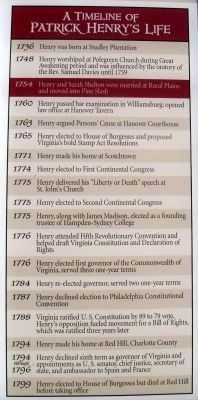
Rural Plains, home of the Shelton family for nearly three centuries, stands on the northern bank of Totopotomoy Creek. Eighteen-year-old Patrick Henry married Sarah Shelton in 1754. Family tradition places the wedding ceremony in the first floor . . . — — Map (db m35014) HM
From Virginia’s founding until the American Revolution 170 years later, the Anglican Church was the only state recognized religion. The government built the churches and the parsonages and paid the clergy with tax money. All other religious groups . . . — — Map (db m32679) HM
For more than a century the Polegreen Church stood as a monument to the Hanover Dissenters and Samuel Davies in the struggle for religious liberty. Though Davies died fifteen years before the American Revolution, his influence and revolutionary . . . — — Map (db m32674) HM
Hanover County. Area 512 Square Miles. Formed in 1720 from New Kent, and named for the electorate of Hanover. Patrick Henry and Henry Clay were born in this county. In it were fought the battles of Gaines's Mill, 1862, and Cold . . . — — Map (db m25366) HM
Hanover County. Area 512 Square Miles. Formed in 1720 from New Kent, and named for the Electorate of Hanover. Patrick Henry and Henry Clay were born in this county. In it were fought the battles of Gaines's Mill, 1862, and Cold . . . — — Map (db m15455) HM
Sadie Heath Cabaniss laid the foundation for professional nursing in Virginia and was the founder of the VCU School of Nursing in 1893. Cabaniss, who held leadership positions in both state and national nursing organizations, led the movement to . . . — — Map (db m69106) HM
Hanover County was organized in 1720 and named for George I, King of England and former elector of Hanover in Germany. Seventeen years later (between 1737 and 1738), construction of the courthouse structure began and was completed in 1743. The . . . — — Map (db m32691) HM
Cradle of Religious Freedom
From time to time, the power of a unique person and place changes the course of history. Here at Polegreen, between 1747 and 1759, the Reverend Samuel Davies inspired a small rural . . . — — Map (db m60967) HM
In December 1763, the Historic Hanover Courthouse was the site of the famous Parsons’ Cause, an opening salvo of the American Revolution. During the Parsons’ Cause trial, Patrick Henry voiced one of the first American objections to denial of the . . . — — Map (db m32692) HM
Only archaeological remnants of Studley survive today, but in the 18th century this was the site of an impressive two-story brick house. Studley was built by John Syme in the 1720s for his wife Sarah Winston. After his death, she married John Henry. . . . — — Map (db m46775) HM
St. John’s Church symbolizes the foundations of our republic and the founding ideal of liberty. Here, Patrick Henry’s masterful argument summoned Americans toward independence with the immortal words, “Give me liberty or give me death” . . . — — Map (db m32695) HM
Richard Southgate, a lawyer, came to Newport in 1795. He was appointed Commonwealth Attorney for Campbell County in 1798,
voted State Representative in 1803, and served as State Senator from
1817-1821. The city of Southgate was named for him; at . . . — — Map (db m279754) HM
Upon Patrick Henry’s marriage to Sarah Shelton in 1754, he received for her dowry a 300-acre tract of land and six slaves. Like many Virginians with small farms, Henry labored in the fields with his slaves. Much of the soil at Pine Slash had been . . . — — Map (db m46754) HM
James Apostles Fields was born into slavery in Hanover County, Virginia, in 1844. During the Civil War, Fields and his brother George escaped to Hampton, where in 1862 they found refuge as "contrabands of war" at Fort Monroe. James Fields served . . . — — Map (db m10611) HM
When Samuel Stanhope Smith, our first president, named the College after English anti-Royalists, he clearly agreed with Patrick Henry’s revolutionary vision. Thus it was logical that Henry should be elected a Founding Trustee in November 1775, . . . — — Map (db m54480) HM
Scotchtown is best known as the site from which Patrick Henry rode to Richmond in March of 1775 to deliver his infamous “Liberty or Death” speech. . Some have even suggested that the house, where he had been forced to confine his wife Sarah due to . . . — — Map (db m281425) HM
After three decades of public service, Patrick Henry retired in 1794 to Red Hill plantation in Charlotte County, which he regarded as "one of the garden spots of the world." He purchased the 700-acre estate and simple story-and-half house in 1794 . . . — — Map (db m128698) HM
The nearby Aspenvale Cemetery contains
the grave of Brig. Gen. William Campbell,
Revolutionary War soldier, militia commander,
and regional political leader. Campbell was
born in Augusta County, Virginia. in 1745, and
by 1768 he had moved to . . . — — Map (db m130440) HM
Albemarle County. Albemarle County was formed in 1744 from Goochland County and named for William Anne Keppel, the second Earl of Albemarle, titular governor of Virginia from 1737 to 1754. A portion of Louisa County was later added to . . . — — Map (db m22780) HM
Virginia public school boards began providing transportation to white students early in the 20th century but frequently denied this service to African Americans. Black children often had to walk miles to school, leading to nonattendance. Across . . . — — Map (db m112286) HM
Born at Studley Plantation six miles east of here was licensed to practice law on April 15, 1760. His awe-inspiring power as an orator was first recognized here at Hanover County Courthouse in his charge to the petit jury on December 1, 1766, in the . . . — — Map (db m32682) HM
Alfred D. "A.D." Price, entrepreneur, spent his youth in Hanover County. After settling in Richmond in the 1870s, he opened a blacksmith shop ca. 1881 that expanded into a livery stable and undertaking business. He moved the enterprise to this site . . . — — Map (db m180209) HM
Before the start of the American Revolution, free Black men were enrolled in local county militias across Virginia. When the war began, these men often volunteered to enlist in Virginia's Continental battalions. Hundreds of Black patriots, including . . . — — Map (db m289579) HM
Professor Albert Terry Wright was born in Hanover County, Virginia. Early in his career, he taught in the black schools of Richmond, Va. In 1901, he began teaching in Lancaster County, Virginia. Between 1905 and 1910, he built the Lancaster County . . . — — Map (db m24639) HM
Fifty yards east is the site of Netherland Tavern (ca. 1822), which was demolished in the 1950s. The tavern served travelers on the Fredericksburg Stage Road and the Louisa Court House Road to the south. It also served rail passengers after the . . . — — Map (db m4840) HM
This white oak tree is the offspring of the mighty white oak which stood in Hanover County, Virginia, for
more than 400 years before being destroyed by Hurricane Isabel in 2003
History relates it provided shade for Robert E. Lee and his staff . . . — — Map (db m99846) HM
Patrick Henry Memorial Park
Made possible by the generosity of
Dr. J. Fulmer Bright
Brigadier General, National Guard
Mayor of the City of Richmond, 1924 to 1940
and by
The City of Richmond
in . . . — — Map (db m235977) HM
This two-story limestone house is believed to have been built about 1880 by Ives Brown for Ichabod and Alice Kingsbury. In 1925 it was purchased by Maria (Williams) James (1859-1940), daughter-in-law of John James, the pioneer surveyor and early . . . — — Map (db m212870) HM
During initial planning of the Belvedere Neighborhood in late 2004, awareness of the existence of buildings and other sites, including a possible family cemetery, associated with the historically African American community of Free State raised . . . — — Map (db m289042) HM
Pioneers in asserting the right to religious freedom, the Caroline Friends (Quakers) held their first meeting nearby on 12 March 1739 together with their partner, Cedar Creek Friends Meeting of Hanover County. At a meeting on 9 May 1767, members . . . — — Map (db m9213) HM
From Virginia’s founding at Jamestown in 1607 until the American Revolution, the Anglican Church was the only officially recognized church.
The government built the churches, maintained the parsonages and paid the clergy, all with . . . — — Map (db m60968) HM
One mile to the south is Red Hill, Patrick Henry’s last home and burial place. The marble stone covering his grave carries the simple inscription, “His fame his best epitaph.”
Henry came here in 1794 and died at his beloved Red Hill . . . — — Map (db m65398) HM
On this site in 1743 ordinary colonists began the successful struggle for greater civil and religious liberty, and inspired a series of events that changed the course of American history. Four years earlier the English evangelist, George Whitefield, . . . — — Map (db m115413) HM
Unveiling the Shenandoah Valley's rich African American stories from Civil War to Civil Rights
African Americans have played a pivotal role in shaping the history and culture of the Shenandoah Valley and our nation. When the Civil War . . . — — Map (db m282848) HM
Born in Hanover County, Virginia, John Scott graduated from Princeton University in 1805 and began practicing law in Ste. Genevieve, a part of the new Louisiana Territory. He was the first American lawyer to permanently reside in the town. He was . . . — — Map (db m180344) HM
This public area perpetuates the name of Colonel James Innes A fearless and brave New Hanover County soldier, he served against the Spanish forces at Cartagena, Colombia, in 1740, and in 1754 commanded the Colonial forces in the . . . — — Map (db m224905) HM
Railroad transportation was still new in 1836 when the Richmond, Fredericksburg and Potomac (RF&P) Railroad Company completed a single track from Richmond to a sawmill 20 miles north in rural Hanover County. At the same time, the RF&P purchased a . . . — — Map (db m296197) HM
Erected in 1729-32 as the Upper Church of Saint Paul's Parish, Hanover County, Slash Church's location next to swampy woods (a "slash" in 18th-century terms) gave it its name. The Reverend Patrick Henry, uncle of the famous patriot, served as rector . . . — — Map (db m16167) HM
Just to the east stood the Clarke house (Lockwood), wherein Gen. Robert E. Lee made his field headquarters, 28-31 May 1864. While here, and though ill, Lee deployed troops to key positions in Hanover County, including Haw's Shop, Totopotomoy Creek, . . . — — Map (db m15753) HM
(west side of Marker): The Fight for North Anna On May 21, 1864, Union General Ulysses S. Grant directed the Army of the Potomac away from Spotsylvania Court House in a turning movement toward Hanover Junction, today known as Doswell. . . . — — Map (db m15164) HM
At 11:00 a.m. six cannon of Major John Lane’s Georgia artillery battalion, followed closely by Brigadier General Edward A. Perry’s weakened 270-man Florida infantry brigade, moved down this road to cover the vital crossing of Ox Ford. As the Union . . . — — Map (db m20946) HM
(side 1)
The Colonial River Road
After centuries of use by native people and the colonists of New Kent County, the road along the Pamunkey River was extended past the tobacco ports of Newcastle and Page’s Warehouse (later . . . — — Map (db m53801) HM
D. Webster Davis, author, clergyman, and educator, was born into slavery in Caroline or Hanover County. He attended public school in Richmond after the Civil War and, beginning in 1879, taught in the city school system for 33 years. In 1887 Davis . . . — — Map (db m180198) HM
Born to Quaker parents in North Carolina, Dolley Payne lived with her family in Hanover County, Virginia until 1783. Following the death of her first husband, John Todd, she married Congressman James Madison in 1794. As First Lady of the United . . . — — Map (db m63669) HM
Born into slavery in Hanover County in 1860, Alfred D. “A.D.” Price moved to Richmond in the late 1870s. Soon after coming to Richmond, he set up a blacksmith shop, which expanded into a livery stable and the funeral home that stands here, now known . . . — — Map (db m5601) HM
Late Italianate style house built for Louis J. Poisson (1880-1891) [sic], real estate broker; and wife Mary Allen (1866-1960), native of Brockville, Ontario, Canada. From 1905 to 1916, the home of Brooke Gwathmey Empie, attorney, state . . . — — Map (db m263714) HM
Nashville was founded as part of
the movement by British colonists
from North Carolina and Virginia
into the Cumberland Valley in the
mid to late 18th century. Richard
Henderson, a magistrate, judge,
and land speculator from
Granville County, . . . — — Map (db m207200) HM
Hanover Tavern was an essential part of the county courthouse complex during the 18th and 19th centuries, serving as the center of social life. For people living on large farms and plantations, whose closest neighbors could live miles away, taverns . . . — — Map (db m32693) HM
1260-1300 A.D.
Per testimony of the Piscataway Tribe in 1660, they were allied with the Patawomeck and Susquehannock Tribes under the leader, Uttapoingassinem, who had come from Eastern Shore. The Patawomecks were later part of the Powhatan . . . — — Map (db m193702) HM
Born in Ashland, Hanover County, Virginia on March 21, 1794. Grew up in Kentucky under guardianship of Henry Clay. Visited Augusta in 1818, where she met and married Richard Tubman, wealthy merchant. After his death in 1836, she became interested in . . . — — Map (db m9995) HM
Nathaniel Hart
Nathaniel Hart was born in Hanover County, Virginia, in 1734. A key figure in the purchase of land in Kentucky from Cherokee Indians, he came to Boonesborough in 1775. Killed in 1782 by Indians near this old house, and buried . . . — — Map (db m239141) HM
Here, in the earthworks in front of you, Confederate Gen. Robert F. Hoke’s troops made a stand on February 20-21, 1865. They were attempting to halt the Union army’s advance on Wilmington, the Confederacy’s principal seaport. Blockade runners, . . . — — Map (db m284188) HM
In 1816, Captain Izard Bacon, a wealthy slaveholder of Henrico County, Virginia, liberated fifty-six slaves. Some of his heirs tried to hold them in slavery; but, after long litigation, they obtained freedom. Charles Granger, a nephew of Bacon, . . . — — Map (db m241494) HM
(Front text)
Monument to General Sumter stands 500 yards south. Born August 14, 1734, in Hanover County, Virginia, he was a frontiersman and Indian fighter. Coming to South Carolina by 1764, he became a planter. As Partisan leader and . . . — — Map (db m27769) HM
Louisa County. Located in the heart of the Virginia Piedmont, this rural county was named for Louisa, a daughter of George II. It was formed from Hanover county in 1742, the county seat is Louisa. Among the county’s historic resources is the . . . — — Map (db m17751) HM
New Yorker Frank Jay Gould planned to build an electric railroad to provide Virginia's Chesapeake Bay waterfront communities a more reliable way of shipping produce and seafood. While that plan did not succeed, his railroad became an alternate . . . — — Map (db m287585) HM
General Washington and General Rochambeau passed here on Sept. 13, 1781 on their way to victory at Yorktown. One mile south, they turned east on state route 605.
The marking of this route is a gift from the French Government. Committee of the . . . — — Map (db m226210) HM
Albert Terry Wright (1871–1944) was born in
Hanover County, Virginia. He taught in the
black schools of Richmond and, by 1908, at
White Stone in Lancaster County. By 1921
Wright was principal of the county’s first
high school for blacks, . . . — — Map (db m24640) HM
Orange County. Formed from Spotsylvania County in 1734, Orange County, a pastoral Piedmont county, was probably named in honor of William IV, the Dutch prince of Orange, who married Anne, the Princess Royal, daughter of George II of England, . . . — — Map (db m108411) HM
Fifth Virginia Cavalry
In an attempt to slow the Union assault, Lomax moved the rest of his brigade including Col. Pate and his Fifth Virginia Cavalry into position in a shallow cut of Telegraph Road. Stuart observed the action taking place . . . — — Map (db m295651) HM
One of ten children, Brooke Smith was born in 1853 to Paulina Thilman (Doswell) and John Snelson Smith, Jr. In Hanover County, Virginia. The family moved to Indiana in 1860 and then to Waco, Texas ten years later. There, Brooke became a clerk at . . . — — Map (db m220761) HM
This is the site of the Virginia State Federation of Colored Women's Clubs, founded by Janie Porter Barrett in 1908 at Bethel AME Church in Hampton. She served as its first president until 1932. The association was an umbrella for club activity . . . — — Map (db m303153) HM
Berkleytown, like many Black communities during the segregation era, was home to a resilient group of individuals whose contributions helped shape both the neighborhood and the broader Ashland area. Many of Berkleytown's residents were the children . . . — — Map (db m296357) HM
Rye was once a thriving settlement along the Manatee River named after Erasmus Rye, who moved to the area in the mid-1840s from Hanover County, Virginia. In 1861, Erasmus married Mary Lucebia Williams, whose family owned the largest homestead in . . . — — Map (db m214570) HM
Sawneytown
Sawneytown was the free African community in Columbia. Per the History of Lancaster County (published in 1883) written by Franklin Ellis and Samuel Evans, in 1813 Robert Magill laid out lots on Filbert Street (present day Union . . . — — Map (db m241490) HM
Six miles east still stands Hanover Courthouse, in which, December, 1763, Patrick Henry delivered his great speech in the “Parsons’ Cause,” when he denounced the British government for vetoing an act of the Virginia General Assembly. — — Map (db m15849) HM
You are now standing in the tip of the famous “inverted V” position constructed by Lee’s army along the North Anna River. The trenches on your left continued to the Little River, while those on the right anchored on a bend in the North Anna below . . . — — Map (db m20961) HM
(Obverse)
Near here lived in 1610 Machumps, brother-in-law to King Powhatan.
Near here were born Patrick Henry and Henry Clay.
In this building on 1st December 1763 Patrick Henry lighted the torch of liberty in the Parson’s . . . — — Map (db m226209) HM
William Howard and Dabney Cosby, who had
worked for Thomas Jefferson, completed this
courthouse in 1827. The second courthouse to
occupy this site, it is a temple-form building
employing the Doric order and was influenced by
Jefferson’s Roman . . . — — Map (db m107577) HM
During the Civil War, salt—essential for the preservation of meat—was vitally important to the massive Union and Confederate armies. Currituck County's location was ideal for salt works, and Knotts Island's residents made salt both here and across . . . — — Map (db m76552) HM
This house was the last headquarters of the Virginia
State Federation of Colored Women’s Clubs, organized
In 1907 by educator and social reformer Janie Porter
Barrett and other women who attended the annual
Hampton Negro Conference. The . . . — — Map (db m129844) HM
In the late 19th and early 20th centuries, opportunities for Black education were scarce in Ashland and Hanover County. Despite these challenges, Berkleytown became a hub for education and community progress, embodying the broader struggle for equal . . . — — Map (db m296362) HM
Early railroads were primarily east-west routes to transport freight between ports on the coast and developing western communities. Chartered in February 1834, the Richmond, Fredericksburg and Potomac Railroad Company (RF&P) would run north and . . . — — Map (db m287572) HM
Berkleytown Heritage Park celebrates the resilience, rich heritage, and strong community spirit of the historically African American Berkleytown neighborhood, which emerged through the determination of families seeking opportunity, security, and a . . . — — Map (db m296365) HM
Hanover County, Virginia
In the darkness of predawn on May 9, forty miles from Richmond, a section of Sheridan's cavalry under Custer's command raided the railroad station at Beaver Dam, in Hanover County. The station was being used as a . . . — — Map (db m295648) HM
Glen Allen, Henrico Courty, Virginia
On May 11, in the mists of the predawn, the combatants were assembling for the battle of Yellow Tavern, just six miles from the gates of Richmond. Stuart's cavalry raced south from Beaverdam to get ahead . . . — — Map (db m295650) HM
Enslaved African Americans once lived and worked here at the country estate of Anthony and Rebecca Robinson, whose house still stands nearby. While their number varied over time, a dozen individuals are listed on an 1860 tax schedule. This . . . — — Map (db m296392) HM
22 enslaved persons were held in bondage on the Rice Farm in the years leading up to the Civil War, making Dr. John W. Rice, the owner of the Rice Farm, one of the largest slaveowners in Shenandoah County. According to the 1850 Slave Schedule . . . — — Map (db m254929) HM
Born in Pennsylvania about 1736. Served in Virginia Provincial Forces against Indians. Vestryman of the Parish-Church Warden. Chairman County Court. Major Orange County Militia. Member North Carolina Assembly, 1760-1768. Instrumental in establishing . . . — — Map (db m286315) HM
This monument is erected by the citizens of Schuylkill County
and bequeathed to their children.
A Record of Gratitude,
for his illustrious services which brought
peace, prosperity and glory to his country.
A Tribute of Admiration, . . . — — Map (db m260828) HM
Thin black lines indicate changes in relevance. Between each pair of lines entries are ordered geographically but all have the same relevance.
* Inflectional forms of words are their plurals, singulars, and possessives as well as gramatical tenses and similar variations.