Near Murphy Road, on the right when traveling south.
In it really began the Civil War. Here was lighted the torch of liberty for all America… For you this is the most hallowed shrine in this country. Henry McDonald, Storer College president
The foundations in front . . . — — Map (db m8318) HM
On King Street East just east of Prince Street South, on the left when traveling east.
On May 10, 1858, American abolitionist John Brown held the last in a series of clandestine meetings here at First Baptist Church. Brown planned to establish an independent republic within the United States and wage guerrilla war to . . . — — Map (db m71386) HM
On Choiceana Avenue north of Lilac Street, on the right when traveling north.
In 1848, a detour branched off the ancient
Mojave Trail (parallels Choiceana Avenue) going
west to Cajon's old summit. In 1870, road maker
John Brown enlarged the detour which with
time became a major thoroughfare. Padre Garces,
Jed Smith, Kit . . . — — Map (db m166560) HM
On Main St, 0.1 miles east of Seventh Avenue, on the right when traveling east.
In 1870, road builder John A.
Brown upgraded a small
path into a road ten miles
in length. Running between
Cajon's old summit and the
prehistoric Mojave Trail, it
passed through Hesperia
diagonally crossing today's
Main Street in the . . . — — Map (db m166640) HM
On Weber Street at Union Street, on the right when traveling east on Weber Street.
In 1846, during American conquest of California, John Brown, nicknamed “Juan Flaco,” rode from Los Angeles to San Francisco in four days to warn Commodore Stockton of the siege of Los Angeles. As a result, troops were sent and the city secured. This . . . — — Map (db m16011) HM
On John Brown Road, 1 mile west of Town Farm Road, on the right when traveling west.
John Brown, the abolitionist, was born at this site on May 9, 1800. He dedicated his life to ending slavery in the United States. Brown became a spokesperson for those abolitionists who believed that slavery could only be eliminated by force. He is . . . — — Map (db m30187) HM
A native of Upson County, Georgia, and a Major General, Confederate States Army, was one of General Lee's most trusted and outstanding officers. He brilliantly led his devoted men in every engagement in which the Army of Northern Virginia . . . — — Map (db m64831) HM
On Washington Street SW at Martin Luther King Jr Dive NW, on the left when traveling south on Washington Street SW.
John Brown Gordon, son of the Rev. Zachariah Herndon Gordon and Mrs. Malinda Cox Gordon, was born in Upson County Feb. 6, 1832. He attended a rural school in Walker County, Pleasant Green Academy in Lafayette, and the University of Georgia. He . . . — — Map (db m86837) HM
On Massachusetts Street south of 6th Street, on the left when traveling south.
On the afternoon of September 14th, 1856, the Free State settlement of Lawrence, Kansas Territory was threatened with invasion by an army of 2700 Pro-slavery Missourians under the command of Generals David R. Atchison and John W. Reid. Encamping . . . — — Map (db m76325) HM
Purchased by Department of Kansas
Womans Relief Corps
Dedicated to the
Grand Army of the Republic
Presented to the State of Kansas
for a memorial park — — Map (db m69244) WM
On 6th Street at Lincoln Avenue, on the left when traveling north on 6th Street.
Osawatomie - the name derives from a combination of Osage and Pottawatomie - was settled in 1854 by Free-State families from the Ohio Valley and New England. John Brown, soon to become famous for his militant abolitionism, joined five of his . . . — — Map (db m69325) HM
On Wilkinson Street, on the right when traveling south.
Liberty Hall A National Historic Landmark This Georgian mansion was begun 1796, by John Brown and named for Lexington, Virginia academy he attended. His wife Margaretta and Elizabeth Love began first Sunday School west of Alleghenies in . . . — — Map (db m84387) HM
On Chestnut Grove Road, on the left when traveling north.
and his associates collected arms and ammunition on the Kennedy Farm (Samples Manor) in Maryland for months prior to the raid on the arsenal at Harpers Ferry, October 17, 1859 — — Map (db m1988) HM
On Chestnut Grove Road, 0.7 miles north of Harpers Ferry Road, on the left when traveling north.
In Memoriam
To the Provisional Army of the United States of America
and their presence at Kennedy Farm the Summer of 1859
John Brown, 59, Hanged
Annie Brown, 16, Sent Home
Martha Brown, 17, Sent Home
John Henry Kagi, 24, Killed . . . — — Map (db m151957) HM
On West Washington Street, on the left when traveling east.
The Washington House Hotel was a major stop on the National Pike and served as a hospital at times throughout the Civil War. Prior to organizing his raid on the Federal arsenal at Harpers Ferry, John Brown registered under the assumed name of "I. . . . — — Map (db m20846) HM
On East Church Street east of South Conococheague Street (Maryland Route 68), on the right when traveling east.
In May 1861, Company I, 13th Massachusetts Infantry was on patrol in Harpers Ferry, and found the engine house where John Brown's raid ended on October 17, 1859. The bell was still in place, and knowing their hometown hook and ladder company needed . . . — — Map (db m131803) HM
Symbol of a nation's efforts to obtain freedom and equality for it's [sic] people
The John Brown Bell
owned, and placed here, John A. Rawlins Building Association, acting in behalf of Akroyd Houde Post 132, the American legion, with the . . . — — Map (db m155034) HM
On St. Antoine Street at Congress Street on St. Antoine Street.
In the home of William Webb, 200 feet north of this spot, two famous Americans met several Detroit Negro residents on March 12, 1859, to discuss methods of abolishing American Negro slavery. John Brown (1800-1859), fiery antislavery leader, ardently . . . — — Map (db m168910) HM
On Court Street (U.S. 9) at Park Street, on the left when traveling north on Court Street.
John Brown’s body guarded by local citizens rested in this court house on the night of Dec. 6, 1859 on its way to burial at his home in North Elba. — — Map (db m136665) HM
Near John Brown Road, 0.5 miles south of New York State Route 73, on the right.
John Brown of Osawatomie
Here Lies Buried
John Brown
Born at Torrington, Connecticut
May 9th, 1800
He emigrated to Kansas in 1855 where he took an active part in the contest against the pro-slavery party. He gained in August 1856 a . . . — — Map (db m46521) HM
Near Sandy Redoubt, on the right when traveling east.
of Pittsfield, Mass. killed October 19th, 1780 at Stone Arabia, N.Y. on his thirty-fifth birthday. Was with Ethan Allen, May 10th, 1775. Made a gallant attempt to retake the fort September 17th to 22nd, 1777 but failed owing to the sturdy defence . . . — — Map (db m9484) HM
On Bowery north of Broome Street, on the right when traveling north.
This is the former site of undertakers McGraw and Taylor, where the body of John Brown was secretly prepared for burial. Executed on December 2, 1859, for the raid on Harper’s Ferry, Virginia, the radical abolitionist had tried to ignite an armed . . . — — Map (db m179403) HM
Near River Road (County Route 19) south of Line Drive, on the left when traveling south.
History of the John Brown Hiking Trails and Mohawk River State Park
Named for local preservationist, the John Brown Hiking Trails wind
through 100 acres on Niskayuna Town land and 117 acres on the
Mohawk River State Park, formerly the . . . — — Map (db m158316) HM
On North Chestnut Street (Ohio Route 46) north of West Jefferson Street, on the left when traveling north.
Owen Brown, Son of John Brown, protected by the Black Strings, a secret society of over
1000 armed men, here described the Battle of Harper's Ferry, Va. the night after his father was hung at Charleston.
Owen Brown, Barclay Coppic, Francis . . . — — Map (db m202379) HM
On Copley Road (Ohio Route 162) at Diagonal Road, on the right when traveling east on Copley Road.
Side A
Born in Torrington, Connecticut, John Brown moved with his family to Hudson, Ohio, in 1805 and lived many years in Portage and Summit Counties. His expert knowledge of sheep and wool led to a business partnership with Colonel Simon . . . — — Map (db m221947) HM
On Ravenna Street at South Main Street on Ravenna Street.
Hudson, Ohio. Boyhood home of John Brown (1800-1859.) Abolitionist John Brown came to Hudson as a boy in 1805 and lived here until 1826. A frequent visitor to Hudson in the ensuing years, Brown attended services at the Free Congregational Church, . . . — — Map (db m158469) HM
On John Brown Road, 0.2 miles south of Pennsylvania Route 77, on the left when traveling south.
John Brown of Ossawatomie and Harper's Ferry worked here as a tanner, 1825-35. The nearby house was then his home. His first wife and son are buried near. — — Map (db m50447) HM
On Pennsylvania Route 77 west of John Brown Road, on the right when traveling north.
On the side road, a short distance south, are the remains of the tannery and home built by the noted abolitionist of Harper's Ferry fame. Here, he lived and worked from 1825 to 1835, employing as many as 15 men in producing leather. — — Map (db m50446) HM
On South Main Street (U.S. 11) at Lincoln Way (U.S. 30), on the right when traveling north on South Main Street.
Preparing for the raid on Harpers Ferry arsenal, John Brown came to Chambersburg in the summer of 1859 wearing a beard as a disguise and using the alias of Isaac Smith. He took up residence at Mary Ritner’s boarding house on East King Street, . . . — — Map (db m201726) HM
The two abolitionists met at a stone quarry here, Aug. 19-21, 1859, and discussed Brown's plans to raid the federal arsenal at Harpers Ferry. He urged Douglass to join an armed demonstration against slavery. Douglass refused, warning the raid would . . . — — Map (db m201754) HM
On East King Street, on the right when traveling west.
Boarded in this house for a while in the summer of 1859 under the name of "Smith". While in Chambersburg, he secretly received firearms and ammunition. Later in 1859, Brown led a raid on the arsenal at Harper's Ferry. — — Map (db m201755) HM
On Park Street (Route 233) at Slabtown Road on Park Street.
Captain John Cooke, one of Brown’s followers, was captured near here on October 25, 1859, nine days after the raid on Harper's Ferry. He was hanged December 16, two weeks after John Brown. — — Map (db m1009) HM
On Powers Street, on the left when traveling east.
The home of John Brown Reflecting the wealth and position gained from his lucrative career as a slave trader, privateer, China trade merchant and Patriot. — — Map (db m56014) HM
Near S. Main Street (U.S. 283) at S. 2nd Street, on the right when traveling north.
Scottish immigrant John Brown (1842-1903) moved west following his theological studies in New York. He married Mary Jane Matthews Larn near Fort Griffin and in 1884 became minister of Albany Presbyterian Church, just as West Texas farmers and . . . — — Map (db m85634) HM
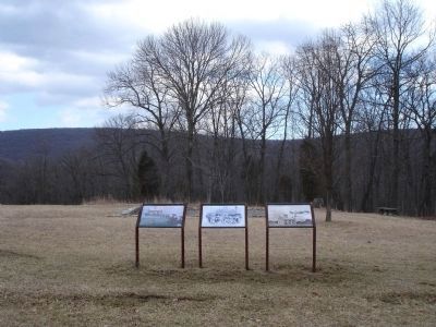
Near Murphy Road, on the right when traveling south.
Here on the scene of John Brown’s martyrdom we reconsecrate ourselves, our honor, our property to the final emancipation of the race which John Brown died to make free… Thank God for John Brown!... and all the hallowed dead who died for . . . — — Map (db m8316) HM
Established 1869 Alexander Murphy 1840-1931 Mollie M. Murphy 1869-1945 Mary Murphy 1834-1908 William J. Murphy 1872-1931 Historical events on the Farm: Battle of Harpers Ferry September 13-15, 1862 General Philip Sheridan's Fortification August . . . — — Map (db m13275) HM
On South Samuel Street at East Hunter Street on South Samuel Street.
This is where seven men were hanged in December 1859 and March 1860 for their part in John Brown’s Raid on Harpers Ferry. The scaffold stood here in a large field. A month after the trial, on December 2, 1859, John Brown was the first to die. He . . . — — Map (db m41650) HM
On S. Samuel Street at Hunter Street, on the left when traveling south on S. Samuel Street.
Within these grounds a short distance east of this marker is the site of the scaffold on which John Brown, leader of the Harpers Ferry raid, was executed December the Second, 1859. — — Map (db m12603) HM
On George Street (West Virginia Route 115) at Washington Street (West Virginia Route 51), on the right when traveling north on George Street.
One of the most famous trials in American history was held in this building in 1859, when John Brown and his followers faced charges of treason against Virginia, inciting slaves to rebel, and murder. Judge Richard Parker presided.
The trial . . . — — Map (db m170247) HM
On Washington Street (Alternate U.S. 340) at Storer College Place on Washington Street.
Harpers Ferry. Named for Robert Harper, who settled here in 1747 and operated ferry. Site purchased for Federal arsenal and armory in 1796. John Hall first used interchangeable gun parts here. Travel route thru Blue Ridge gap, and river, . . . — — Map (db m82777) HM
Near Storer College Place, on the left when traveling south.
Here John Brown aimed at human slavery a blow that woke a guilty nation. With him fought seven slaves and sons of slaves. Over his crucified corpse marched 200,000 black soldiers and 4,000,000 freedmen singing “John Brown’s body lies . . . — — Map (db m158453) HM
On Shenandoah Street at Potomac Street on Shenandoah Street.
That this nation might have
a new birth of freedom,
That slavery should be removed
forever from American soil.
John Brown
and his 21 men gave their
lives.
To commemorate their
heroism, this tablet is
placed on this . . . — — Map (db m167876) HM WM
On South Potomac Street at Shenandoah Street (County Route 340/9), on the right when traveling east on South Potomac Street.
Here is a building with a curious past. Since its construction in 1848, it has been vandalized, dismantled, and moved four times - all because of its fame as John Brown's stronghold. The Fort's "Movements" 1848 Built as fire-engine house for . . . — — Map (db m4420) HM
Near Potomac Street just west of Shenadoah Street (Business U.S. 340), on the right when traveling west.
Commemorated here is the original location of the "John Brown Fort"--the Federal Armory's fire engine house where abolitionist John Brown and his raiders were captured by the U.S. Marines on October 18, 1859. If you look to the south, you will see . . . — — Map (db m10900) HM
Near Potomac Street, on the right when traveling west.
You are in the line of fire. The stone marker in front of you identifies the original site of the armory fire engine house - now known as John Brown's Fort. Barricaded inside the fort, abolitionist John Brown and his men held off local militia and . . . — — Map (db m23413) HM
This plaque is dedicated to the John Brown raiders, a group of men led by John Brown who, at Harpers Ferry on October 17, 1859 struck a blow against slavery.
Killed at Harpers Ferry Jeremiah Anderson • Oliver Brown • Watson Brown • John Henri . . . — — Map (db m103497) HM
Iowa assumed an important place in America’s Underground Railroad history when Missourians closed off the Missouri River to Kansas bound settlers. For Iowa residents involved in helping runaways, the work was a dangerous and illegal business. Most . . . — — Map (db m93885) HM
On First Street north of Omaha Street, on the right when traveling north.
John Brown's Last Iowa Trip 1859
On February 16, 1859 John Brown, with twelve men, women, and children escaping slavery from Missouri, plus his own men, stopped near here at the farm of Jonathan M. Murray.
Murray, a fifty-five . . . — — Map (db m236587) HM
On Chestnut Grove Road, on the right when traveling south.
This is the Kennedy farmhouse, which abolitionist John Brown (using the pseudonym Isaac Smith) leased in July 1859 from Dr. Robert Kennedy's heirs, ostensibly to do some prospecting. Brown's fifteen-year-old daughter, Annie Brown, identified the . . . — — Map (db m169872) HM
On Valley Forge Road (Pennsylvania Route 252), on the left when traveling west.
Brigadier General Henry Knox, Washington’s 27 year old artillery chief, used as his quarters the small stone section of this house. Located upstream on Valley Creek from Washington’s Headquarters, this was the farm home of John Brown and his family. . . . — — Map (db m28876) HM
On Allstadt Hill Road, 0.2 miles north of Millville Road (County Route 27), on the left when traveling north.
The Allstadt House and Ordinary was the home of John H. Allstadt. On the evening of October 16, 1859, John Brown and his "army" of would-be slave liberators launched their attack on Harpers Ferry from Kennedy Farm just across the Potomac River in . . . — — Map (db m145216) HM
On S Seminary Street at E Congress Street, on the left when traveling south on S Seminary Street.
Edge Hill Cemetery contains the graves of Fontaine Beckham and John Avis, two participants in the saga of John Brown’s Raid in October 1859. Beckham was the mayor of Harpers Ferry then and one of four civilian casualties. Ironically, though John . . . — — Map (db m41672) HM
On North George Street at East Washington Street (U.S. 340), on the right when traveling north on North George Street.
In this courthouse, John Brown, the abolitionist, was tried and found guilty of treason, conspiracy and murder. He was hanged four blocks from here on December 2, 1859. — — Map (db m1742) HM
Near Constitution Highway (State Highway 20), on the right when traveling west.
On the morning of May 6, Confederate General John B. Gordon occupied the far Confederate left, in this vicinity, with his brigade of Georgians. Gordon reconnoitered to his left and front and discovered the Union right flank to be vulnerable to an . . . — — Map (db m7384) HM
There sleeps beneath
all that was mortal of
GEORGE W. TURNER
Born at
Wheatland in the County of Jefferson
Jany. 11th 1814.
Graduated at West Point 1831,
and fell nobly maintaining the
rights of his State at
Harpers . . . — — Map (db m103553) HM
The Battle of Osawatomie was fought on this site on the morning of August 30, 1856. John Brown led a force of about 30 Free State guerilla fighters in battle against John Reid and 250 proslavery militia men. John Brown chose this battlefield, . . . — — Map (db m69286) HM
On Shenandoah River Drive (Alternate U.S. 340) at High Street (Alternate U.S. 340), on the right when traveling east on Shenandoah River Drive.
The stone and brick walls in front of you show the outline of the Small Arsenal. The actual foundation of this former weapons storehouse lies below ground. In 1959 National Park Service archaeologists first excavated the foundation—100 years . . . — — Map (db m143937) HM
On Potomac Street at Shenandoah Street (Business U.S. 340), on the right when traveling east on Potomac Street.
On the night of October 16, 1859, Heyward Shepherd, an industrious and respected Colored freeman, was mortally wounded by John Brown's raiders in pursuance of his duties as an employee of the Baltimore and Ohio Railroad Company. He became the first . . . — — Map (db m126128) HM
On East 2000th Road at North 175th Road, on the right when traveling south on East 2000th Road.
"Let not the knives of pro-slavery men be sheathed while there is one abolitionist in the Territory." —Squatter Sovereign proslavery newspaper in Atchison, Kansas Territory, June 10, 1856
On this site at dawn on June 2, 1856, the . . . — — Map (db m20051) HM
On Laurel Mills Road (County Route 618) at Richmond Road (County Route 729), on the left when traveling east on Laurel Mills Road.
Dangerfield Newby (ca. 1820-1859), a free mulatto for whose family this crossroads is named, was the first of John Brown’s raiders killed during the attack on Harpers Ferry on October 16, 1859. He was the eldest child of Henry Newby and a slave, . . . — — Map (db m50611) HM
John Reid's proslavery militia men set up cannon on John Brown's Free State Guerilla force's flank here on this high ground and fired into John Brown's Free State guerilla forces line of defense while Reid's proslavery militia men attacked the . . . — — Map (db m69225) HM
Near Tenth Street, 0.2 miles north of Main Street.
On the morning of August 30, 1856, John Brown led about 30 antislavery men into battle against 250 proslavery Missourians. This Battle of Osawatomie raged on the site of John Brown Memorial Park.
Local tradition maintains that the statue of . . . — — Map (db m21125) HM
On Washington Street (Maryland Route 343) at Ocean Gateway (U.S. 50), on the right when traveling west on Washington Street. Reported permanently removed.
The Slavery Conflict Deepens
During the 1850's the deep-rooted conflict between pro-slavery and anti-slavery Americans intensified. The 'abolitionists' were united around the common long-run goal of abolishing slavery. But they differed . . . — — Map (db m109916) HM
On 4th Corso (Nebraska Route 2) west of South 19th Street, on the right when traveling west.
This cabin, one of Nebraska’s oldest structures, was built in the summer of 1855 as the home of Allen B. Mayhew, his wife, Barbara Ann (Kagy) Mayhew, and their sons, Edward and Henry. John Henry Kagi, Barbara Mayhew’s brother, lived briefly with . . . — — Map (db m177269) HM
On Western Reserve Greenway north of Ohio Route 307, on the right when traveling north.
Ashtabula County and The Western Reserve
Ashtabula County was part of the New Connecticut (or Western) Reserve, which spanned northeastern Ohio. Nearly two thirds of the early settlers in Ashtabula County came from Connecticut. Many took . . . — — Map (db m213959) HM
On East North Street east of North Mildred Street, on the right when traveling east.
John Blessing was born in Germany and came to the United States and made his home in Baltimore, Maryland. He moved to Charles Town 1853 and purchased a large brick building on the corner of Charles and Washington Streets (Now known as the Shugart . . . — — Map (db m132445) HM
On Shenandoah Street at Potomac Street, on the right when traveling east on Shenandoah Street.
"The War That Ended Slavery"
Abolitionist Frederick Douglass, from his 1881 Storer College Commencement speech
"I want to free all the negroes in this [slave] state ... if the citizens interfere with me I must only burn . . . — — Map (db m143940) HM
Near Fuller Road west of South 19th Street, on the right when traveling west.
Pioneers for Emancipation
The man who built this house was James Cunningham Jordan (1813–1891). He and his wife Melinda were the earliest settlers in Walnut Township, Iowa (now West Des Moines). When he was thirty-three Mr. Jordan built a . . . — — Map (db m236559) HM
On Hog Alley at Potomac Street, on the right when traveling north on Hog Alley.
You are standing directly across the street from the main entrance of one of the nation's first military industrial complexes. The U.S. Armory at Harpers Ferry, now covered by an embankment of dirt and rubble, produced the deadliest weapons of its . . . — — Map (db m24919) HM
Nothing in the struggle over slavery in Kansas did more to inflame the nation than the mass killing which took place May 19, 1858, about four miles northeast of this marker. Charles Hamelton who had been driven from the territory by Free-State men, . . . — — Map (db m4359) HM
The Battle of Osawatomie was a military victory for proslavery forces, and a moral and propaganda victory for Free State forces in Kansas Territory. John Brown became a symbol of Free State resistance to proslavery forces, and inspired Free . . . — — Map (db m69243) HM
John Reid's proslavery militia men formed up in two lines on horseback here and attacked John Brown's Free State guerillas in an aggressive charge. The proslavery Militia men were mounted on horses that were not trained for combat, and began to . . . — — Map (db m69221) HM
On Bowery at Rivington Street, on the right when traveling south on Bowery.
Remarkably surviving for over 200 years, 206 Bowery is one of the few row houses on the Bowery that still retains most of its Federal style characteristics, including its 2 ½-story height, 3-bay width, gambrel roof and pair of gable dormers. . . . — — Map (db m133618) HM
Near India Street at Tockwotton Street, on the right when traveling east.
Tockwotton and the Indiamen
The close of the War of Independence in 1783 found the local economy dominated by maritime trade. Wharves along South Water Street became overcrowded with merchant ships, as depicted in the 1800s scene above. In . . . — — Map (db m151689) HM
Near Gordon W Shelton Boulevard, 0.7 miles north of Willow Lane, on the left when traveling north.
Every day that a human being had to endure the horrors of slavery required extreme bravery. Yet, the resilience of slaves in the constant company of this evil stare of existence is worthy of note and admiration. For many, it is incomprehensible . . . — — Map (db m176132) HM
On Newman Avenue (Rhode Island Route 152) at Pawtucket Avenue (Rhode Island Route 1A), on the right when traveling east on Newman Avenue.
The area of today’s City of East Providence was inhabited by the Pokanoket Tribe, later known as the Wampanoag, for over 10,000 years. In 1621, the Massasoit Ousamequin entered into a mutual protection agreement with the English settlers in . . . — — Map (db m207459) HM
Near Charmian Road east of Buchanan Trail East/Waynesboro Road, on the left when traveling east.
To spark a civil war, John Brown came to Ritner Boarding House in Chambersburg, PA, where he began to plan his famous raid on Harper’s Ferry, in 1859. At the time, Brown was calling himself Isaac Smith. By mid summer, he had rented the Kennedy . . . — — Map (db m202048) HM
On West Boscawen Street (U.S. 50) at North Stewart Street, on the right when traveling west on West Boscawen Street.
This is the former location of the Winchester Medical College. In the spring of 1862, Union soldiers from Gen. Nathaniel P. Banks's command allegedly entered the building and discovered a partially dissected African American boy. They also found . . . — — Map (db m126603) HM
On King Street East just east of Prince Street South, on the left when traveling east.
From 1783 until the 1860s, abolitionists in British North America took part in the fight to end slavery both at home and in the United States. Thanks to the determination of colonial officials, anti-slavery organizations, and the thousands of . . . — — Map (db m71391) HM
On Wagon Train Road, 0.5 miles south of California Route 138, on the right when traveling south.
Erected in honor of the brave pioneers of California in 1917 by pioneers Sheldon Stoddard, Sydney F. Waite, John Brown Jr., George Miller, George M. Cooley, Silas C. Cox, Richard Weir, Jasper N. Corbett — — Map (db m157687) HM
On Kentucky Street at Dunlap Boulevard, on the right when traveling east on Kentucky Street.
Constructed in 1842 by Diego Sepulveda, nephew of Antonio Maria Lugo, this is believed to be the oldest house in San Bernardino County. The land, formerly controlled by San Gabriel Mission, was part of Rancho San Bernardino, granted to the Lugos in . . . — — Map (db m143658) HM
On Conde Street, on the left when traveling south.
Originally built as the home of San Diego’s John Brown in 1850, the house was converted to a church by Don Jose Aguirre in 1858. Father Antonio D. Ubach , formally a missionary among the Indians, was parish priest here from 1866 to 1907. It is said . . . — — Map (db m11652) HM
On North Beach Street north of International Speedway Boulevard (U.S. 92), on the right when traveling north.
To the memory of the known Revolutionary Soldiers who removed to Florida Evan Andress • John Bessent • John Brown • Henry Edwards • John Fletcher • William Gay • Zachariah Gherkins • Morton Gray • James Hall • Joab Horne • Amos Latham • John Liles . . . — — Map (db m46877) HM
On Willow Park Drive at Walnut Avenue (Georgia Route 52), in the median on Willow Park Drive.
William Scott and Frances Brown McCarty began laying out a neighborhood here in 1927. By 1950, influential Dalton residents had established one of the city’s earliest subdivisions. McCarty residents pioneered and maintained the Dalton carpet and . . . — — Map (db m19294) HM
A Nation at Odds
The mid 1800s were a time of turmoil and tragedy in the U.S. The issue of slavery polarized the nation. It created a moral, political, and economic dilemma. The struggle over slavery ultimately led to the Civil War, splitting . . . — — Map (db m39862) HM
On 6th Street north of Parker Avenue, on the right when traveling north.
One of the first churches in Kansas, this church was built by a Congregationalist group and is typical of the church structures built during pioneering days in Kansas. It was dedicated to public worship in 1861, and its first pastor was the Reverend . . . — — Map (db m69319) HM
On Beaumont Avenue, 0.1 miles north of Dixie Manor, on the left when traveling north.
Built by Beriah Magoffin, Sr., Beriah Magoffin, Jr. and his wife Anne Shelby, granddaughter of Isaac Shelby, first governor of Kentucky, resided here after 1839. Later owned by Benjamin Mills noted gunsmith and commander of Harper’s Ferry at the . . . — — Map (db m152954) HM
In an age of high infant mortality, Sarah and John Brown experience more than their share of loss. Plagued by smallpox, yellow fever, cholera, typhoid, measles and mumps, early Baltimore families buried one of every three children before their . . . — — Map (db m30564) HM
On Baltimore Avenue (U.S. 1) at Milestone Way, on the right when traveling south on Baltimore Avenue.
This plaque and garden commemorate the site of Brown’s Tavern, a Prince George’s County Historic Site that served travelers on the former Baltimore-Washington turnpike from the early 1830’s to the early 1990’s. It was constructed and owned by the . . . — — Map (db m2983) HM
Situated at the confluence of the Potomac and Shenandoah Rivers, Harpers Ferry was named for Robert Harper, a millwright who continued a ferry operation here in 1747. The waterpower of the two rivers - harnessed for industry - generated tremendous . . . — — Map (db m5033) HM
On Parshallville Road near Cullen Road, on the right when traveling west.
This mill, one of the last water-powered grist mills to operate in Michigan, was built in 1869. It was purchased by Tom Walker and John Browning for $10,000 in 1878. From then on the Walker family was involved with the mill for three generations. . . . — — Map (db m178068) HM
Near Sandy Redoubt, on the right when traveling east.
Built by the French 1755-1758 General James Abercrombie defeated by the Marquis de Montcalm, July 8, 1758 Captured by Sir Jeffery Amherst July 27, 1759 and renamed Fort Ticonderoga Captured by Ethan Allen May 10, 1775 Captured by Sir John Burgoyne . . . — — Map (db m9447) HM
382 entries matched your criteria. The first 100 are listed above. Next 100 ⊳
* Inflectional forms of words are their plurals, singulars, and possessives as well as gramatical tenses and similar variations.