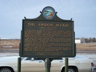
On North Street 0.2 miles north of Maple Avenue, on the right when traveling north.
The 1862 Sioux Uprising, a result of unjust government treatment, claimed many Indian and non-Indian lives. Near this place on August 25, 1862, two of its victims, Judge Joseph B. Amidon and his son, William, were killed while making hay on their . . . — — Map (db m184710) HM
On Main Avenue south of 5th Street, on the right when traveling south.
Early day justice in Minnehaha County, Dakota Territory, overlooked innocence when gallows were erected near this site for the hanging of Thomas Egan, a pioneer immigrant farmer from County Tipperary in Ireland. Egan settled in Dakota . . . — — Map (db m227957) HM
On 255th Street 0.2 miles west of 255th Street, on the right when traveling west.
In 1908 the Western Bridge and Construction Co. of Omaha, Nebraska, built this Pratt-Through Truss Bridge. Workers fastened beams together with diagonal bracing to create a strong rigid framework. Each beam of a truss bridge shares a portion of the . . . — — Map (db m184708) HM
On 258th Street (County Road 130) 0.8 miles west of 475th Avenue (State Route 115), on the right when traveling west.
Lindbergh Landing
Col. Charles A. Lindbergh was the first to fly non-stop from New York to Paris. The 33½-hour solo flight on May 20-21, 1927, in a single engine monoplane, was a phenomenal aeronautical achievement which fascinated the . . . — — Map (db m181301) HM
On 481st Avenue (South Dakota Route 11) 0.5 miles north of Route 42, on the right when traveling south.
Ole B. Iverson, his father Iver, brother Peter and brother-in-law Andy had no established roads to follow when they came to Dakota Territory in 1868. They had to wade or ford rivers and streams as best they could. These men, from near Decorah, Iowa, . . . — — Map (db m181919) HM
Near West 18th Street west of South Grange Avenue, on the right when traveling east.
In June of 1894, inspired by tales of marvelous progress in medicine at the 1893 Chicago Columbian Exposition, a small group of Lutheran clergy and laymen banded together to form a hospital association. They organized Sioux Falls Hospital . . . — — Map (db m238362) HM
On West 12th Street (State Highway 42) just west of South Kiwanis Avenue, on the right when traveling east.
On June 7, 1941, Vera Bushfield, wife of the governor of South Dakota, smashed a bottle of champagne against the towering bow of a new battleship and proudly proclaimed, “I christen thee South Dakota!” While an 80 piece band from Sioux Falls’ . . . — — Map (db m40516) HM
In late 1873, the young frontier town of Sioux Falls, Dakota Territory, population 150, established its first cemetery organization, Mount Pleasant Cemetery. Initially, twenty acres of land were purchased at a location east of town presumed to be . . . — — Map (db m181920) HM
On East 10th Street (State Highway 42) west of South Jessica Avenue, on the right when traveling west.
The Reverend Thomas Berry, an Episcopal clergyman, took the first steps toward the establishment of a formal program for the education of deaf children in Dakota Territory. Berry taught at schools for the deaf in Maryland and New York before moving . . . — — Map (db m194744) HM
On State Highway 42 0.7 miles east of E 26th St, on the right when traveling west.
From 1887 to about 1913, this area, bordering the Big Sioux River, was the thriving community of East Sioux Falls. The city boasted a hotel, several boarding houses, saloons and retail stores, a town hall, a cricket team, at least three . . . — — Map (db m181620) HM
On West 12th Street just east of South Dakota Avenue, on the right when traveling east.
Arriving in Sioux Falls, Dakota Territory in 1878, Eliza Tupper Wilkes quickly became one of the community leaders of the small prairie town. She was born Eliza Smith Tupper on October 8, 1844 in Houlton, Maine. As a young woman she . . . — — Map (db m184707) HM
On Mall Avenue at East 9th Street, on the right when traveling west on Mall Avenue.
In the fall of 1856, speculators from the Western Town Company of Dubuque, Iowa, claimed a town site at the Falls of the Big Sioux River. The next spring, men joined them from the Dakota Land Company of St. Paul. Together, they founded Sioux Falls . . . — — Map (db m184704) HM
On West 9th Street at South Minnesota Avenue, on the right when traveling east on West 9th Street.
On September 11, 1900, Theodore Roosevelt spoke from a platform at this intersection of Ninth Street and Minnesota Avenue. Thousands turned out for "Roosevelt Day" to see and hear the 41-year-old governor of New York, who was running . . . — — Map (db m184700) HM
The Dubuque House, Sioux Falls’ first hotel, was built about 350 yards due west of this spot by Wilmot W. Brookings and members of the Western Town Company of Dubuque, Iowa, in September 1857. In the previous year, they had staked out a 320 acre . . . — — Map (db m184711) HM
On North Garfield Avenue at West Bailey Street, on the right when traveling south on North Garfield Avenue.
Soon after this area was platted in 1889, the city of Sioux Falls installed a community well which was located at this spot. It was a source of water for livestock and household use. Local residents referred to it as the "town pump." Here they hand . . . — — Map (db m184689) HM
On Aspen Boulevard west of South Splitrock Boulevard (State Route 11), on the right when traveling west.
For hundreds of years, the land on which Brandon is situated was the home and hunting grounds of Native Americans. A prehistoric village site and numerous burial mounds are located nearby. Many early Brandon area settlers were of Norwegian descent; . . . — — Map (db m181916) HM
On 258th Street (County Road 130) 0.8 miles west of 475th Avenue (State Route 115), on the right when traveling west.
Leonard Renner, a German immigrant and a Union Army Civil War veteran, came to Dakota Territory in 1878. He acquired farm land in Mapleton Township. Years later, the Chicago, Milwaukee, St. Paul and Pacific Railroad built a track . . . — — Map (db m181296) HM
On South Kiwanis Avenue north of West 46th Street, on the left when traveling north.
Following the advent of powered flight at Kitty Hawk, North Carolina in 1903, the dawning air age slowly arrived in Sioux Falls. In June 1912, a Curtis Pusher biplane was the first airplane to enter the skies over the city. It was delivered . . . — — Map (db m182227) HM
On South Splitrock Boulevard (State Highway 11) 0.4 miles south of South Sioux Boulevard, on the right when traveling south.
The Eminija Mounds, the largest and most numerous burial mound group in South Dakota, were built by Native Americans of the Late Woodland Period and may date from 500 to 1000 A.D. The original group consisted of at least 38 dome-shaped burial . . . — — Map (db m198936) HM
On 244th Street 0.3 miles west of 476th Avenue, on the left when traveling west.
On a windy, cold, and damp 3rd of November 1938, the eyes and ears of the nation focused on Dell Rapids, host to the greatest annual competition of American agriculture: the National Corn Husking Contest. An estimated 125,000 people from all over . . . — — Map (db m222273) HM
On 265th Street (South Dakota Route 42) at 456th Avenue ( Route 19), on the right when traveling west on 265th Street.
On plains where Native Americans once hunted vast herds of buffalo, a country general store called Wellington Corner sprang up at this location in 1921. The first building, which became the ice house, was constructed by Luther and Anna Gage. The . . . — — Map (db m183487) HM
On West Madison Street 0.1 miles east of North Covell Avenue, on the right when traveling east.
Enraged over the broken promises of the white man, the Santee Sioux, led by Chief Little Crow, launched the "War of the Outbreak" - or "Dakota War" - in August, 1862, along the Minnesota River. Little Crow ordered White . . . — — Map (db m184699) HM
The Queen Bee Mill, a goliath among mills in early Dakota Territory, once stood tall and proud here on the bank of the Big Sioux River. A large quartzite deposit on the site was used to build an impressive seven-story flour mill.
The . . . — — Map (db m124251) HM
On W 17th Street at S Main Avenue on W 17th Street.
All Saints School was founded in 1884 by Bishop William Hobart Hare as an Episcopalian
boarding school for daughters of missionary clergy men and other young women in Dakota Territory. In memory of his late wife and in tribute to all women, he . . . — — Map (db m184709) HM
On W 17th Street 0.1 miles west of S Phillips Ave, on the left when traveling west.
On December 28, 1890, 500 well-armed soldiers of the Seventh Cavalry surrounded a tepee camp of 350 Lakota prisoners of war at Wounded Knee Creek S.D. During a search for weapons the next morning, a Lakota accidentally discharged his rifle. . . . — — Map (db m131968) HM
On W 8th Street 0.1 miles west of S Duluth Avenue.
Richard Franklin Pettigrew was 20 years old in the spring of 1869 when he first came to Dakota Territory from Wisconsin as a member of a government surveying party. Pettigrew decided to settle in Sioux Falls, and join in the building of a city. . . . — — Map (db m184712) HM
On South Minnesota Avenue at West 9th Street, on the right when traveling north on South Minnesota Avenue.
A frontier town such as Sioux Falls, Dakota Territory, built almost entirely of wood and surrounded by highly flammable prairie grass could be swiftly consumed by uncontrolled fire. Without protection, farms and towns were vulnerable . . . — — Map (db m184701) HM
On South Phillips Avenue north of West 10th Street (State Highway 42), on the right when traveling south.
On January 5, 1891, Frist Lieutenant Edward W. Casey attempted to reconnoiter a Ghost Dance camp near Pine Ridge Indian Agency in western South Dakota. When Casey was directed to leave, Tasunke-Ota (Plenty Horses), a camp guard, shot and killed him. . . . — — Map (db m192242) HM
On 9th Street east of Phillips Avenue, on the right when traveling east.
Originally part of Minnesota Territory, Sioux Falls City was founded during a time of widespread townsite speculation on the frontier. In 1856 members of the Western Town Company of Dubuque, Iowa, arrived at the Falls of the Big . . . — — Map (db m184703) HM
On North Kiwanis Avenue at West Rice Street, on the left when traveling north on North Kiwanis Avenue.
In March 1889, several months before South Dakota achieved statehood, Evan B. Meredith, first president of the University of Sioux Falls, platted a future residential community within the northwest boundary of early Sioux Falls. His purpose . . . — — Map (db m184687) HM
On West Madison Street at North Lincoln Avenue, on the right when traveling west on West Madison Street.
In March 1889, several months before South Dakota achieved statehood, Evan B. Meredith, first president of the University of Sioux Falls, platted a future residential community within the northwest boundary of early Sioux Falls. His purpose . . . — — Map (db m184688) HM
On Broadway Avenue at Elm Street, on the left when traveling east on Broadway Avenue.
Valley Springs east gateway to Dakota Territory was established during 1868-1873 when pioneers settled by the spring fed creeks. The first white child born in Minnehaha County was in this area. Town was incorporated in 1878. First election was . . . — — Map (db m181357) HM
On South Perry Place 0.1 miles north of State Highway 42, on the right when traveling north.
to droop, to become weak and tired, to lose confidence and enthusiasm
header:Quarrymen
East Sioux Falls Quarrymen. Photo courtesy of Siouxland Heritage Museums.
Progress
By 1896, the . . . — — Map (db m199079) HM
On North Phillips Avenue north of West 5th Street, on the right when traveling north.
(panel 1)
”If you didn't drink whiskey, play cards, use your fists or otherwise intimidate, you didn't belong in the arena with Frank Pettigrew… a man who came to the Dakotas with nothing but desire, talent and ambition. He pitched his . . . — — Map (db m124226) HM
On South Perry Place 0.1 miles north of State Highway 42, on the left when traveling north.
to change, to develop gradually to become more advanced and complex
Plant Communities
A plant community is a group of living plant species that all naturally grow together in one location. All the plants in a community share the . . . — — Map (db m199154) HM
On Main Street south of 2nd Street, on the right when traveling south.
Frank Leroy Farrar was born in Britton on April 2, 1929, son of third-generation Marshall County homesteaders. He was an Eagle Scout and Boys State governor and graduated from Britton High School. Farrar then earned business and law degrees from the . . . — — Map (db m197801) HM
On South Perry Place 0.1 miles north of State Highway 42, on the right when traveling north.
to germinate, to grow from a seed, to emerge and grow rapidly
header:Rowena Quarry
The Neighboring Rowena Quarry, 1890. Photo Courtesy of Siouxland Heritage Museums in Sioux Falls, South Dakota [SHM . . . — — Map (db m199078) HM
On South Main Avenue at West 11th Street (State Highway 42), on the right when traveling south on South Main Avenue.
Nils A. Boe was born on September 10, 1913 in Baltic. The son of a Norwegian Lutheran minister, he came to Sioux Falls as a child and graduated from Washington High School. Boe earned his bachelor's and law degrees from the University of Wisconsin, . . . — — Map (db m184706) HM
On North Phillips Avenue south of West 5th Street, on the right when traveling north.
Train loads of visitors swarmed to Sioux Falls on October 14, 1899, to see the first president ever to visit South Dakota. The city appeared to be “one blaze of national colors.” Hundreds of flags waved, and patriotic bunting stretched “from . . . — — Map (db m124182) HM
On South Phillips Avenue 0.1 miles south of East 14th Street, on the right when traveling north.
The Lyon Family Home
The home, pictured above, was built by Jacob and Katie Schaetzel in 1881, on the northeast corner of 11th Street and Dakota Avenue. Jacob Schaetzel was village president, and later was elected as the first mayor of . . . — — Map (db m199677) HM
On West 5th Street (North Dakota Avenue) west of North Main Avenue, on the right when traveling east.
(side one)
Between 1877 and 1909, Sioux Falls was known as the “Divorce Capital of the Nation.” Lenient residency laws and multiple divorce grounds were available in Dakota Territory and South Dakota. Wealthy men and women from . . . — — Map (db m124187) HM
On South Main Avenue south of West 11th Street (State Highway 42), on the right when traveling south.
(side one)
After the United States declared war against Spain in 1898, Jonas H. Lien enlisted into the First Regiment of the newly formed South Dakota Volunteer Infantry. The regiment was mustered into federal service at Camp Dewey in . . . — — Map (db m124196) HM WM
This spot is near the center of an area called “Siouxland,” so named by writer Frederick F. Manfred (1912–1994). Manfred established a distinct identity for this region, the drainage basin of the Big Sioux River. It includes parts . . . — — Map (db m92175) HM
On Interstate 90, on the right when traveling west.
No one knows when the first people came to live on the land that now comprises Minnehaha County, but native Woodland and Oneota peoples were here over 1000 years ago. The Big Sioux River which flows south through the county, appears on maps in . . . — — Map (db m179043) HM
Near 252nd Street east of 481st Avenue, on the right when traveling west.
Within short distance of this hill of peace eleven original pioneer families came in 1873 to claim the land and to give us birth
Johannes E. Berdahl ·
Mrs. Lars Brandvold ·
C. O. Henjum ·
Synneve Henjum ·
Thor Hermanson ·
Olaus . . . — — Map (db m208421) HM
Near 264th Street 0.5 miles west of 484th Avenue (County Road 109), on the left when traveling west.
The 160-acre tract in this Nature Area was homesteaded by John A. Samuelson, (top left) originally from Sweden, who settled here in 1869. His first home was a dugout in the hillside where he and his wife Anna (bottom left) lived for three years and . . . — — Map (db m222432) HM
On South Main Avenue at West 1st Street (County Road 110), on the right when traveling south on South Main Avenue.
John Edmund Colton
John E. Colton was born in Wisconsin in 1857. In April 1878 he moved to Minnehaha County, Dakota Territory, where he filed a preemption homestead claim to 160 acres of land. He remained on the land for 90 days, as required by . . . — — Map (db m186912) HM
On North Drive 0.3 miles east of East Maple Street, on the right when traveling east.
Memorial to
the Pioneers
of
Minnehaha County
1856 – 1889
Erected by the
Minnehaha County
Historical Society
- 1949 -
The Pioneer Memorial
Honors the early settlers who faced the harsh and lonely . . . — — Map (db m184705) HM
On West 9th Street at South Dakota Avenue on West 9th Street.
After two decades of presidents' appointing governors and other officials from outside the territory, a statehood movement began in the 1880s in the southern half of Dakota Territory. The movement was led by a small group of middle - class . . . — — Map (db m169922) HM
Near 264th Street 0.5 miles west of 484th Avenue (County Road 109), on the left when traveling west.
The Samuelson Family
Dakota Pioneers
John A. Samuelson was born in Sweden in 1837. He immigrated to the United States in 1868 and lived for one year in Iowa. In 1869, he came to Dakota Territory and filed on a homestead of 160 acres, . . . — — Map (db m222435) HM
On South Perry Place 0.1 miles north of State Highway 42, on the left when traveling north.
to grow from a seed or spore into a new individual
header:
Photo Courtesy of Siouxland Heritage Museums, Sioux Falls, South Dakota [SHM 41.15.20]
Illinois Central Railroad
In 1887, the quarries at East . . . — — Map (db m199157) HM
On South Perry Place 0.1 miles north of State Highway 42, on the left when traveling north.
to sprout, to grow like a plant
header:
Photo Courtesy of Siouxland Heritage Museums in Sioux Falls, South Dakota [SHM 78.35.28]
Life of a Stonecutter
The life of a quarry worker included long hours and . . . — — Map (db m199150) HM
On South Phillips Avenue south of East 12th Street, on the right when traveling north.
(side 1)
In 1891, the Unites States Government purchased the southeast corner lot on Phillips Avenue and 12th Street for $8,000 for the construction of a government building. While everyone agreed that the fledgling city of Sioux Falls . . . — — Map (db m124096) HM
On South Perry Place 0.1 miles north of State Highway 42, on the left when traveling north.
to develop leaves, known as foliage
header:
Photo Courtesy of Siouxland Heritage Museums in Sioux Falls, South Dakota [SHM 92.8.16]
Saloons
East Sioux Falls was filled with quarrymen that needed an . . . — — Map (db m199153) HM
On South Phillips Avenue south of 9th Street, on the right when traveling south.
Western Surety Building
P.H. Edmison built the Edmison Block in 1875. A fire destroyed the building in 1889.
The Edmison-Jameson Building, later known as the Minnehaha Building, was a 6-story building designed by Architect Wallace . . . — — Map (db m184832) HM
On South Perry Place 0.1 miles north of State Highway 42, on the right when traveling north.
to grow well, to be strong and healthy, especially because conditions are right
header:East Sioux Falls
East Sioux Falls, 1890. Photo Courtesy of Siouxland Heritage Museums [SHM 78.35.32]
Pink . . . — — Map (db m199106) HM
Thin black lines indicate changes in relevance. Between each pair of lines entries are ordered geographically but all have the same relevance.
* Inflectional forms of words are their plurals, singulars, and possessives as well as gramatical tenses and similar variations.