
67 entries match your criteria.
Historical Markers and War Memorials in New Zealand
By Shirley A Stirling, December 27, 2025
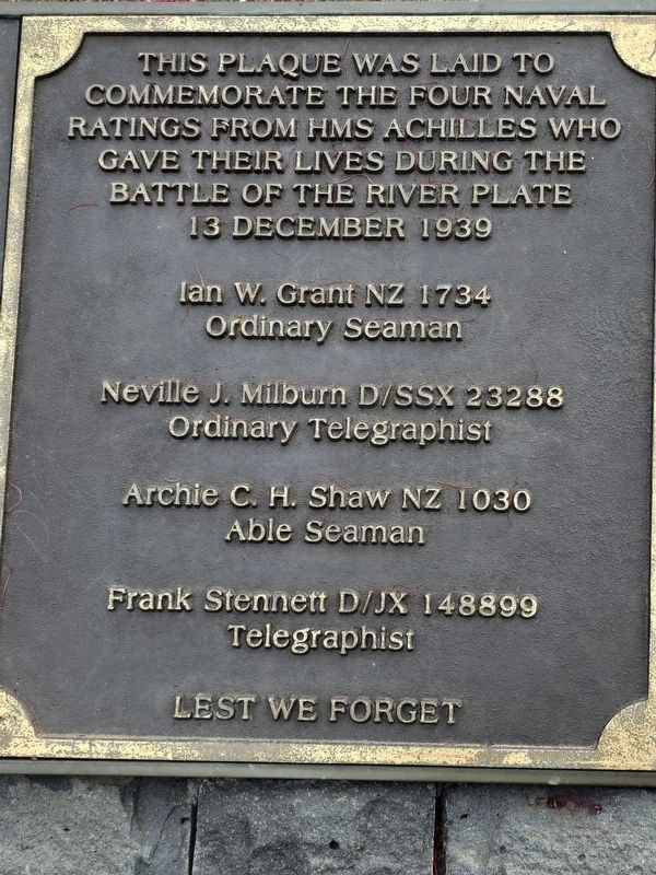
HMS Achilles Marker
1 ► New Zealand, Auckland, Auckland, Saint Heliers — Achilles Point —  |
| On Cliff Road. | |||
| 2 ► New Zealand, Auckland, Auckland Central — Salvation Army — |
| On Albert Street at Victoria Street W, on the right when traveling south on Albert Street. | |||
| 3 ► New Zealand, Auckland, Central Business District — Administrator House — (Alliance Insurance Building) — |
| On O'Connell Street, on the right when traveling south. | |||
| 4 ► New Zealand, Auckland, Central Business District — Ferry Building — |
| On Quay Street, on the right when traveling west. | |||
| 5 ► New Zealand, Auckland, Central Business District — General Building — (Yorkshire House) — |
| On Shortland close to O'Connell, on the left when traveling west. | |||
| 6 ► New Zealand, Auckland, Central Business District — Lord Freyberg Statue — |
| On Freyberg Place. | |||
| 7 ► New Zealand, Auckland, Central Business District — Police Station & Court — |
| On O'Connell Street at Chancery, on the left when traveling north on O'Connell Street. | |||
| 8 ► New Zealand, Auckland, Central Business District — South African War Memorial — |
| Near Princes Street. | |||
| 9 ► New Zealand, Auckland, Central Business District — The Dilworth Building — Auckland City Council Schedule ‘B’ — |
| On Queen Street close to Customs Street E, on the left when traveling south. | |||
| 10 ► New Zealand, Auckland, Mangere — Jean Batten — 1909-1982 — |
| On Cyril Kay Road west of Fred Ladd Way, on the right when traveling west. | |||
| 11 ► New Zealand, Auckland, Mount Eden — Auckland Provincial Surveyors Association — |
| On Puhi Huia Road, on the right when traveling north. | |||
| 12 ► New Zealand, Auckland, Mount Eden — Maungawhau Mt. Eden — |
| On Puhi Huia Road east of Mount Eden Road, on the right when traveling north. | |||
| 13 ► New Zealand, Auckland, Mount Eden — Sacred Site - Maungawhau — |
| On Mount Eden Road north of Summit Road, on the right when traveling north. | |||
| 14 ► New Zealand, Auckland, Viaduct Harbour — The Ubiquitous Scow — "Auckland was built on the scow." - Anon — |
| On Customs Street West, on the right when traveling west. | |||
| 15 ► New Zealand, Bay of Plenty Region, Rotorua District, Rotorua — Boer War 1899-1902 — |
| On Queens Drive. | |||
| 16 ► New Zealand, Bay of Plenty Region, Rotorua District, Rotorua — Government Gardens — Destination Rotorua — |
| On Queens Drive, on the right when traveling east. | |||
| 17 ► New Zealand, Bay of Plenty Region, Rotorua District, Rotorua — Nga Whakairo Tupuna (Ancestral Carvings) at the Hinemoa and Arawa Street entrances to the gardens — |
| On Hinemaru Street at Queens Drive, on the right when traveling south on Hinemaru Street. | |||
| 18 ► New Zealand, Bay of Plenty Region, Rotorua District, Rotorua — 2 — Prince’s Gate Arches — |
| On Hinemaru Street at Queens Drive, on the left when traveling south on Hinemaru Street. | |||
| 19 ► New Zealand, Bay of Plenty Region, Rotorua District, Rotorua — 20 — The Croquet Pavilion and sports in the gardens — |
| On Queens Drive, on the left when traveling west. | |||
| 20 ► New Zealand, Bay of Plenty Region, Rotorua District, Rotorua — This stone laid by Te Naera Te Houkotuku — |
| On Fenton Street at Arawa Street, on the left when traveling south on Fenton Street. | |||
| 21 ► New Zealand, Bay of Plenty Region, Rotorua District, Rotorua — 3 — Wylie Memorial — |
| On Queens Drive. | |||
| 22 ► New Zealand, Bay of Plenty Region, Rotorua District, Rotorua, Lakeside — Priest & Radium Hot Springs — A Divine Discovery — |
| Near Hatupatu Drive, on the right when traveling north. | |||
| 23 ► New Zealand, Bay of Plenty Region, Rotorua District, Rotorua, Tikitere — George Bernard Shaw — the man who named Hells Gate, Rotorua — |
| Near State Highway 30 at Lake Rotokawau Road, on the right when traveling west. | |||
| 24 ► New Zealand, Bay of Plenty Region, Rotorua District, Rotorua, Whakarewarewa — New Zealand Centennial — 1840-1940 — |
| On Huarere Street near Hinganoa Drive, on the right when traveling east. | |||
| 25 ► New Zealand, Bay of Plenty Region, Rotorua District, Rotorua, Whakarewarewa — 24 — Roto Kanapanapa — Green Lake — |
| Near Hinganoa Drive south of Huarera Street, on the left when traveling south. | |||
| 26 ► New Zealand, Bay of Plenty Region, Rotorua District, Rotorua, Whakarewarewa — 10 — Te Arawa Hāhi Mihinare / Te Arawa Anglican Church — |
| On Huarere Street east of Hinganoa Drive, on the left. | |||
| 27 ► New Zealand, Canterbury Region, Christchurch, Addington — Addington Water Tower — |
| On Clarence Street. | |||
| 28 ► New Zealand, Canterbury Region, Christchurch, Christchurch Central City — Oi Manawa Canterbury Earthquake National Memorial — |
| Near Oxford Terrace. | |||
| 29 ► New Zealand, Canterbury Region, Selwyn District, Arthur's Pass Village — Arthur’s Pass Chapel — Arthur's Pass Historic Walk — |
| On West Coast Road at Crusher Road, on the right when traveling south on West Coast Road. | |||
| 30 ► New Zealand, Canterbury Region, Selwyn District, Arthur's Pass Village — The Locomotive Turntable — Arthur's Pass Historic Walk — |
| On West Coast Road. | |||
| 31 ► New Zealand, Manawatu-Wanganui Region, Rangitikei District, Taihape — Taihape Clock Tower — |
| On Huia Street at Hautapu Street, on the left when traveling east on Huia Street. | |||
| 32 ► New Zealand, Manawatu-Whanganui Region, Ruapehu District, Mt. Ruapehu — Tongariro National Park World Heritage Site — |
| On Manawatu-Whanganui Region Route 48 south of Tawera Place, on the right when traveling north. | |||
| 33 ► New Zealand, Otago Region, Dunedin, Central Dunedin — Bank of New Zealand — Historic building — |
| On Princes Street at Rattray Street, on the right when traveling north on Princes Street. | |||
| 34 ► New Zealand, Otago Region, Dunedin, Central Dunedin — Dunedin Cross — |
| On Queens Gardens (Otago Region Route 1) east of Burlington Street. | |||
| 35 ► New Zealand, Otago Region, Dunedin, Central Dunedin — Former Bank of New Zealand — |
| On Princes Street at Rattray Street, on the left when traveling south on Princes Street. | |||
| 36 ► New Zealand, Otago Region, Dunedin, Central Dunedin — Geoff Todd's School of Self-Defence — |
| On Stuart Street at Castle Street, on the right when traveling east on Stuart Street. | |||
| 37 ► New Zealand, Otago Region, Dunedin, Central Dunedin — In Memory of Captain William Cargill — |
| On Rattray Street at Princes Street, on the left when traveling west on Rattray Street. | |||
| 38 ► New Zealand, Otago Region, Dunedin, Central Dunedin — Law Courts — |
| On Stuart Street at Castle Street, on the right when traveling east on Stuart Street. | |||
| 39 ► New Zealand, Otago Region, Dunedin, Central Dunedin — Passchendaele Memorial — |
| On Castle Street. | |||
| 40 ► New Zealand, Otago Region, Dunedin, Central Dunedin — The Exchange — |
| On Rattray Street at Princes Street, on the left when traveling west on Rattray Street. | |||
| 41 ► New Zealand, Otago Region, Dunedin, Larnachs Castle — W.J.M. Larnach Mansion — |
| Near Camp Road north of Castlewood Road, on the left when traveling north. | |||
| 42 ► New Zealand, Otago Region, Dunedin, Harington Point — Quo Fas et Gloria Ducunt — |
| Near Harington Point Road. | |||
| 43 ► New Zealand, Otago Region, Dunedin, Harington Point — Taiaroa Head Jail — |
| On Harington Point Road, on the left when traveling north. | |||
| 44 ► New Zealand, Otago Region, Queenstown-Lakes District, Arrowtown — Bank of New Zealand — |
| On Buckingham Street at Buckingham Street, on the left when traveling east on Buckingham Street. | |||
| 45 ► New Zealand, Otago Region, Queenstown-Lakes District, Arrowtown — Invited but Unwelcome — The harsh reality of goldfield life — |
| Near Buckingham Street north of Villiers Street, on the left when traveling north. | |||
| 46 ► New Zealand, Otago Region, Queenstown-Lakes District, Arrowtown — The Dairy — |
| On Ayr Avenue. | |||
| 47 ► New Zealand, Otago Region, Queenstown-Lakes District, Arrowtown — The Hayloft — |
| Near William Paterson Close north of Ayr Avenue, on the right when traveling north. | |||
| 48 ► New Zealand, Otago Region, Queenstown-Lakes District, Arrowtown — The Manure Room — |
| On Ayr Avenue. | |||
| 49 ► New Zealand, Otago Region, Queenstown-Lakes District, Arrowtown — The Mary Cotter Tree — |
| On Wiltshire Street at Buckingham Street, on the right when traveling north on Wiltshire Street. | |||
| 50 ► New Zealand, Otago Region, Queenstown-Lakes District, Arrowtown — Welcome to the Arrowtown Chinese Settlement — and the story of a remarkable people — |
| Near Buckingham Street north of Villiers Street, on the left when traveling north. | |||
| 51 ► New Zealand, Otago Region, Queenstown-Lakes District, Queenstown — New Zealand Moa (Dinomithiformes) — |
| On Beach Street, on the left when traveling west. | |||
| 52 ► New Zealand, Otago Region, Queenstown-Lakes District, Roaring Meg — Crown Range Summit — |
| On Crown Range Road 6.9 kilometers Gibbston Highway ( Highway 6), on the right when traveling north. | |||
| 53 ► New Zealand, Otago Region, Queenstown-Lakes District, Wanaka — Wānaka Police Stations — |
| On Dunmore Street, on the left when traveling west. | |||
| 54 ► New Zealand, Southland, Southland District, The Key — Te Wahipounamu — South West New Zealand World Heritage Area — A natural treasure of world significance — |
| Near Te Anau-Mossburn Highway (State Highway 94) 0.5 kilometers west of Lagoon Creek Road, on the left when traveling west. | |||
| 55 ► New Zealand, Tasman, Tasman District, Torrent Bay — Dumont d'Urville — |
| On Abel Tasman Coast Track. | |||
| 56 ► New Zealand, Waikato Region, Thames-Coromandel District, Coromandel — National Bank Coromandel — |
| On Kapanga Road at Tiki Road, on the right when traveling north on Kapanga Road. | |||
| 57 ► New Zealand, Wellington, Wellington Council, Wellington, Wellington Central — Hikitia Floating Crane — |
| On Commonwealth Walkway at Great Harbour Way, on the right when traveling north on Commonwealth Walkway. | |||
| 58 ► New Zealand, Wellington Region, Wellington, Kelburn — Seddon Memorial — |
| On Kinross Street, on the right when traveling north. | |||
| 59 ► New Zealand, West Coast Region, Buller District, Cape Foulwind — Guiding Light — |
| On Cape Foulwind Walkway 0.3 kilometers west of Lighthouse Road. | |||
| 60 ► New Zealand, West Coast Region, Buller District, Karamea — The History of the Karamea Estuary — |
| On Ray Street 0.5 kilometers west of Wharf Road. | |||
| 61 ► New Zealand, West Coast Region, Grey District, Greymouth — Goldrush — Founding of Greymouth — |
| On MacKay Street at Custom Street, on the right when traveling east on MacKay Street. | |||
| 62 ► New Zealand, West Coast Region, Grey District, Greymouth — The Purchase of Westland: 1860 — |
| On MacKay Street, on the right when traveling east. | |||
| 63 ► New Zealand, West Coast Region, Westland District, Ōkārito — Frontier Building … Legendary Man — |
| On The Strand, on the right when traveling north. | |||
| 64 ► New Zealand, West Coast Region, Westland District, Franz Josef / Waiau — Don't let rowi become just a memory — |
| On Main Road, on the right when traveling north. | |||
| 65 ► New Zealand, West Coast Region, Westland District, Franz Josef / Waiau — Peter's Pool — Reflections of the past — |
| Near Douglas Walk. | |||
| 66 ► New Zealand, West Coast Region, Westland District, Haast — Welcome to Ship Creek — Nau mai, haere mai, tauti mai ki Tauparikaka — |
| Near Haast Highway (West Coast Region Route 6), on the left when traveling north. | |||
| 67 ► New Zealand, West Coast Region, Westland District, Jackson Bay — Jackson's Bay — |
| On Haast-Jackson Bay Road at Pier Street, on the left when traveling south on Haast-Jackson Bay Road. | |||