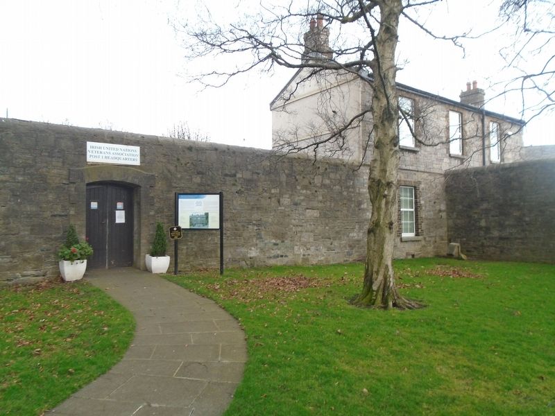
The Irish United Nations' Veterans' Association (IUNVA) was founded in 1989. Its members are personnel who served abroad with the United Nations, while in service, with the Defence Forces, An Garda Síochána or the UN Field Service. . . . — — Map (db m240970) HM
In 1955, the parade ground, the school yard and the old cemetery were amalgamated to create a large
memorial area at Arbour Hill. Designed by Gerry McNicholl of the Office of Public Works, the memorial area features a curved wall . . . — — Map (db m240935) HM WM
The Bakers' Guild was founded by Royal Charter of Edward IV in 1478. This tablet with their arms and dated 1752, probably commemorates the transfer of the Guild's headquarters from the Bakers' Tower, Essex Bridge to Bakers' Hall, 8, Upper Bridge . . . — — Map (db m240684) HM
The Easter 1916 burial plot and memorial are located in an open terrace of Wicklow
granite in what was once part of Arbour Hill Prison. The leaders of the Rising were held
at various places in the city (Pearse and Heuston at Arbour . . . — — Map (db m240933) HM WM
United Irish Catechism
What is that in your hand? It is a branch.
Of what? Of the TREE of Liberty.
Where did it first grow? In America.
Where does it bloom? In France.
Where did the SEEDS fall? In Ireland.
——————————————————— . . . — — Map (db m240761) HM
This stone of Wicklow granite marks the location of
the common grave in which lie the bodies of many of
those executed in Dublin after the 1798 Rebellion.
———————————
[Marker facing street]
This memorial marks the Croppy's Acre where . . . — — Map (db m240635) HM
In 1599, Sir William Temple, a renowned teacher and philosopher, entered the service of the Lord Deputy of Ireland. In 1609 Temple was made Provost of Trinity College, Dublin and Master Chancery in Ireland and moved to this country.
Sir . . . — — Map (db m240585) HM
This well was probably constructed when Eustace Street was laid out between 1680 and 1720. Before that this area was a salty tidal shore on the right bank of the river Poddle where it joined the Liffey just outside the walls of medieval . . . — — Map (db m241144) HM
Towards the end of the 8th century Scandinavian Vikings began to invade and then gradually settle and mix with Irish society. They founded our capital city, Dublin in 988.
Brian Boru, High King of Ireland at this time sought to reduce viking . . . — — Map (db m240567) HM
Howth Abbey, St. Marys
Sigtrygg, King of Dublin, founded the first church here in 1042. When this church was amalgamated with another on Ireland's Eye in 1235, it was re-founded by Luke, Archbishop of Dublin. Much of the present church dates . . . — — Map (db m27205) HM
A Fishing Village
References to the fishing industry in Howth can be found from the twelfth century, although in the seventeenth century the port was also known in the area as a base for pirates roaming Dublin Bay. In Elizabethan times a . . . — — Map (db m27057) HM
The monument was erected by
The Howth Fishermens Association
and commemorated the lives
of all persons lost at sea,
no matter where or no matter how.
[Representative memorial plaques follow]
Fishermen
Brian Faherty and . . . — — Map (db m26806) HM
Howth from Old Norse Hofuth (a promontory);
Binn Éadair (the hill of Éadar) is the Irish name.
This church, dedicated to the Blessed Virgin Mary, was collegiate; that is, it was served by a college or community of . . . — — Map (db m27183) HM
Sixth President of the
International Olympic Committee
1972 - 1980
President of the
Olympic Council of Ireland
1950 - 1973
This commemorative bronze bust was unveiled by
Dr. Jacques Rogge
Eight[h] President of the . . . — — Map (db m27050) HM
Seeing the meaning
When viewing a piece of sculpture one can see many different layers of meaning. The clues given here are only the first layer of meaning and are meant only as a gateway through which you can go on your way to see meanings . . . — — Map (db m25301) HM
[Excerpt from marker]
History
There has been a settlement at Malahide (Mullach Íde in Gaelige meaning the Hill of the Hydes) since ancient times. The Vikings landed in 795 AD and the Danes were settled here from 897 AD. In 1185 the . . . — — Map (db m72714) HM
This sculpture celebrates Portmarnock's unique role in world aviation history. This beach, known as the Velvet Strand, was used as a runway for the first successful East-West Transatlantic flight, on 24th June 1930.
After a gruelling 33 hours . . . — — Map (db m25788) HM
What's in a name?
Portmarnock is names after St Marnock, a prominent missionary who founded a church in the area.
The Velvet Strand and Aviation History
It was from the Velvet Strand, on 24th of June 1930, that the famous Australian . . . — — Map (db m83440) HM
By 1855 the Mass House which had served the people of Celbridge for over one hundred years was in a poor state of repair. It was situated in front of the present church. It was known as a Mass House as Mass was the only service allowed in it. . . . — — Map (db m143176) HM
The Irish Poor Law System
The origins of the Irish Workhouse system lie in the Irish Poor Law Act passed by the parliament of the United Kingdom in 1838.
The Act, entitled an Act for the More Effectual Relief of the Poor in Ireland was . . . — — Map (db m143231) HM
"Along the banks of that river, amid the groves and bowers of Swift and Vanessa, I grow convinced that I was right."
Henry Grattan
INTRODUCTION
Celbridge (Cill Droichid: 'Church by the Bridge' originally angicised to . . . — — Map (db m143210) HM
Tá Eastát Castletown, Cill Droichid i mbaile clúiteach Arthur Guinness agus tailte cúirtéireachta Jonathan Swift, údar Gulliver's Travels.
Lonnaithe sa stair chlúiteach seo, is é Castletown an teach mór ar stíl Phallaidiach is mó clú . . . — — Map (db m143409) HM
• The original Celbridge Manor was built at the beginning of the 18th century by Bartholemew Van Homrigh, a wealthy Dutch merchant, who was Purchaser of Provisions and Commissioner of Ordnance for the victorious forces of King William III.
• . . . — — Map (db m143209) HM
Pray
for the souls
of all
poor and afflicted
whose bodies
have been laid
in this cemetery
since 1841
R.I.P.
—————————————
This Holy Ground is . . . — — Map (db m143226) HM
Through this gate from 1841 onwards passed the
bodies of deceased inmates of the Celbridge Union
Workhouse on their way to burial in these
grounds. The Workhouse System conducted its
burials in a characteristically efficient manner
and . . . — — Map (db m143227) HM
C Company, 1st Battalion,
Dublin Brigade, I.V.
Four Courts & Interned
in Stafford & Frongoch 1916
Unveiled by Cllr. Frank O'Rourke
21st February 2016 — — Map (db m143171) WM
Erected by his numerous friends of all classes
and of all creeds in memory of
Sir Gerald Dease, K.C.V.O.
Born 17th July 1831, died 18th October 1903.
A man of stainless honour, who used his high position
and great . . . — — Map (db m143180) HM
The origins of our town
In ancient times there were five principal roads in Ireland. One of these roads was known as the "Slí Mhór". It extended from Dublin Bay to Galway Bay and forded the river Liffey in Celbridge just below where the Mill . . . — — Map (db m143545) HM
In 1740-41, famine spread across Europe, following a great frost[,] the so-called 'Black Spring'. Rivers froze, and water-powered mills that ground grain into flour stopped working. This led to a flour scarcity, hoarding by wholesalers, . . . — — Map (db m143165) HM
Muiris Mac Gearailt a thóg 1176 : rinneadh méadh air ó am go ham ina dhiaidh sin. [?] dtús na 14ú aoise ba é príomháit chónaithe ghearaltach chill dara é, chuir "Tomás an Tsíoda" i dtreo cosanta in aghaidh na sasanach é i . . . — — Map (db m143158) HM
The Church of St. Mary's - a living centre of worship today - is also a monument to the Fitzgerald family whose history is permanently linked with the nearby Geraldine Castle. Originally built as a private chapel for the castle, in 1248 St. Mary's . . . — — Map (db m143157) HM
This Large East Window is unusual because it is made of wood and set in stone. During the restoration of 1770 this window was taken from the church of Laraghbryan, which had fallen into ruins[.] Note how the stonemason corrected the misspelling in . . . — — Map (db m143155) HM
Eaglais Mhuire
Tráth dá raibh, gnáth-eaglais ab ea Eaglais Mhuire, ceann de na heaglaisí is sine in Éirinn. Tar éis an iliomad blianta d'athchóiriú agus den fhorbairt chúramach a bheith críochnaithe, sa lá atá inniu ann tá Músaem . . . — — Map (db m136916) HM
This graveyard is believed to have been in use from the 7th century. The earliest surviving memorials date from the 1630s. The graveyard contains 281 memorials but many more people are known to have been buried here. A map of all memorials is . . . — — Map (db m136967) HM
Halla an Bhaile
Ó dá fhocal sa sean-Bhéarla, "tol" agus "sael", a chiallaíonn 'halla cánach', a thagann ainm an fhoirgnimh is suntasaí ar an tSráid Ard.
Tógadh Halla an Bhaile thart ar 1578 agus atógadh i 1761 é. D'fhreastail sé ar . . . — — Map (db m136706) HM
Tholsel
High Street's most significant building, gets its name from the old English words "tol' and "sael" meaning the hall of taxes. The Tholsel was erected circa 1578 and re-built in 1761. It has served Kilkenny as a meeting place, a . . . — — Map (db m136798) HM
Ceantar an Bhaile Aird
Bhí tógáil ballaí baile ina-gné lárnach ag luathfhorbairt Chill Chainnigh, a bhí faoi thionchar na Normannach agus cuireadh tús leis thart ar an mbliain 1240. Tá ag Cill Chainnigh trí limistéar mhúrtha: . . . — — Map (db m136518) HM
OUR HERITAGE
The three highly successful Irish International Grand Prix held in Dublin's Phoenix Park between 1929 and 1931 led to races being held on street and road circuits throughout Ireland.
For those that could not afford a . . . — — Map (db m136790) HM
Teach Martin Archer, a bhfuil a arnas le [illegible words] scríbhinne
Insignia Martin Archer...Kilkenniensis
—————————————
The house of Martin . . . — — Map (db m136515) HM
Sir Richard Shee a thóg an teach déirce do bhoicht Chill Choinnigh 1581 agus d'fhág sé maoin le huacht aige 1603. Tugtaí iostas do dhaoine bochta ann go dtí an 19ú aois nuair a bhí droch - bhail air.
This almshouse was built . . . — — Map (db m136908) HM
Trach Capall Colles
Ba é Cumann Chill Chainnigh um Fhóirithint ar Ainmhithe a choimisiúnaigh an trach ólacháin aolchloiche seo in 1902, ar chostas caoga ocht punt agus cúig scilling. Ba é an tUasal Colles ó na hOibreacha Aolchloiche . . . — — Map (db m136903) HM
Following the fire of 20th September 1985
this building was renovated under the
guidance of Cllr. Michael I. McGuinness
Mayor 1985-86 and Cllr. Margaret Tynan
Mayor 1986-87 and re-opened 19th Feb. 1987 — — Map (db m136787) HM
In Honour Of
all those
Kilkenny Citizens
who died
In Past Wars
or on service
with
The
United Nations
———————————
In Ómós
Shaoránaigh
uile
Chill . . . — — Map (db m136911) WM
The threshold and other rough stone
was salvaged from one of the last
thatched houses in the village.
It was demolished in the year 2000. — — Map (db m24721) HM
Brief History of Longford
Longford is a focal point of the northern midlands where the provinces of Leinster, Ulster and Connaught all converge. Longford, where history and literature, tradegy and triumph are all woven together, takes its . . . — — Map (db m27946) HM
Brief History of Longford
Longford is a focal point of the northern midlands where the provinces of Leinster, Ulster and Connaught all converge. Longford, where history and literature, tradegy and triumph are all woven together, takes its . . . — — Map (db m27498) HM
The Mouth of the Ford of Stones
The ancient name of Lanesborough is Béal Átha Liag which means “Mouth of the Ford of Stones”. Situated at the northern tip of Lough Ree, or Loch Rí - meaning the “Lake of . . . — — Map (db m27424) HM
[Northeast Face]
To Perpetuate the Memory
of the 284 Gallant Soldiers
of the County Longford
who fell in the Great World War.
This Cross was erected by
the generous subscriptions of
their sorrowing relatives,
comrades and . . . — — Map (db m27355) WM
Monasterboice — from Mainistir Bhuithe (the Monastery of Buithe)
This is the only early Irish monastery whose name incorporates the Irish word mainistir.
Monasterboice was founded by St Buite, who died around 520.
The . . . — — Map (db m24628) HM
Round Tower
The round tower was the Irish reaction to the Norse raids on monasteries in the 10th/11th century A.D. These tapering buildings, over 100 feet high, served as watch-towers, belfries, repositories for church valuables and as . . . — — Map (db m24693) HM
A 13th century reconstruction on the foundations of an earlier monastic building, used as a small parochial church after the monastery at Monasterboice had come to an end. It remains little of architectural interest. The east windows and most of . . . — — Map (db m24694) HM
At one time a church consisting of nave and chancel stood on this site. In the 13th century re-edification the west gable was moved back to add over two feet to the nave. The chancel having by this time disappeared, the plain round arch in the east . . . — — Map (db m24717) HM
Bective Abbey — from Mainistir Bheigthí (Abbey of Beigtheach)
This Cistercian abbey was founded in 1147 as a “daughter house” of Mellifont Abbey.
The community here was Anglo-Norman. In 1386 men of Irish birth . . . — — Map (db m24752) HM
Author of “The Red Flag”
which became the anthem of the
International Labour Movement
Born Rathniska, Kilskyre 1852
Died Lewisham, London 1929
Oh, grant me an ownerless corner of earth,
Or pick me a hillock of stones,
Or . . . — — Map (db m27347) HM
Erected by the People of
Culmullen and District
to the memory of the Men and Women
of Wexford and Meath
who died for their Country
and lie buried in the surrounding area
There were two periods of intense
Rising activity around . . . — — Map (db m33354) HM
Donaghmore Church and Round Tower
A monastery was reputedly founded here in the 5th century by St Patrick, who placed it in the care of St Cassán, whose relics were venerated here. The Round Tower was not built until the 11th or 12th century. . . . — — Map (db m22542) HM
Close to the Courthouse along the western perimeter of the village green is Connell's House, the oldest house in Duleek. This building was in existence at the time of the famous Battle of the Boyne in 1690. — — Map (db m24793) HM
The Memorial Garden
is named after
Vol. Joe Coombes, Platin Road.
Vol. Noel Gallagher, Mountfield, Co. Tyrone
Vol. Harry McCormick, Prioryland, Duleek
and is in memory of
all those who dedicated their lives
to . . . — — Map (db m27220) HM
Duleek Courthouse was built in 1838 by John Trotter as a sessions house for the Meath Grand Jury. It was designed by Francis Johnston. The main architectural features are the Doric door-case and fanlight, a simplified eaves pediment and corner . . . — — Map (db m24803) HM
The original house was built in 1795. It was built in three stages and was acquired by Fr John Kearney to accommodate the parish priest and the curate. It was re-roofed in 1993 and presides over the very elegant village green.
At the back of the . . . — — Map (db m24801) HM
One of the great churches of the 12th century, St. Mary's Abbey, was built by the Augustinians on lands presented to them by Hugh de Lacy, Overlord of Meath.
In the 1500s a massive square tower was built alongside the earlier round tower. The . . . — — Map (db m26384) HM
William of Orange and Mary accepted the throne of England in 1698, supplanting King James II who took refuge with his ally and sponsor Louis XIV of France. The tensions between James and William would reach their highpoint in 1690 at the battle of . . . — — Map (db m24802) HM
An introduction to Fordstown
Fordstown is named after the Norman-Irish Ford family, who lived in the area. One part of the townland is sometimes referred to as Ballaghboy. Today, Fordstown is a growing, vibrant community. ‘Fordstown Street . . . — — Map (db m27318) HM
Here rest the remains of
Silvester O'Dempsey Esq.
Who departed this life the 31 Dec. 1817
In the 70 year of his age
A Man
of the most steady Friendship
Unblemished Integrity extensive charity
And
Universal Benevolence
This frail . . . — — Map (db m26423) HM
Headfort Place was purposely widened and lined with trees in the 18th century to make it a suitable setting for its attractive Georgian houses. It is also here that a site for a parish church was donated to the Roman Catholic community by Lord . . . — — Map (db m27339) HM
The courthouse, built in 1801, was designed by the prominent Irish architect Francis Johnston. Johnston also designed the General Post Office and Nelson's Pillar in Dublin, and Townley Hall, County Louth.
A Vantage Point to the Past . . . — — Map (db m27340) HM
This tower is located on the grounds of St Columba's church and was built in the 10th century as part of the early Christian monastery. Such towers were referred to as a cloigteach meaning bell tower. Modelled on early Italian belfries, they were . . . — — Map (db m26440) HM
This 9th century high cross, the cross of the gate of the Kells monastery, is one of five high crosses still surviving in Kells. The cross of the gate, currently at or near its original site, was a termon cross and signified that a fugitive could . . . — — Map (db m27341) HM
Diarmuld MacCarroll, High King of Tara, is said to have granted the dun of Cenannus to St Columcille in the 6th century for the purpose of establishing a monastery. This may explain why in 804 the Columban community on the island of Iona . . . — — Map (db m26444) HM
Suffolk Street is an anglicisation of the ancient name Siofac, the meaning of which is today uncertain. The Annals of the Four Masters mentions a fire in 1156 burning the area of Kells from the cross of the gate to Siofoic. The name . . . — — Map (db m26424) HM
This wall marks the boundary of the original monastery and was rebuilt in 1714. When part of the wall collapsed after heavy rains in 1997, it was discovered to have no foundation. It was rebuilt again in 1998, this time with reinforced bulwarks. — — Map (db m26402) HM
Erected
to the memory of the poor
interred here
during the operation
of the
English Poor Law System.
1838 - 1921.
R. I. P.
In the immediate aftermath
of the Great ‘Famine’, this mass
burial place was opened in 1851 for . . . — — Map (db m27326) HM
The tower, a mock lighthouse, was erected in 1791 by the First Earl of Bective in memory of his father Sir Thomas Taylor. The architect was Henry Baker who completed the design of the Kings Inns in Dublin after Gandon. The tower has an internal . . . — — Map (db m27324) HM
Within the great mound of Knowth there are two passage-tombs and around it, eighteen satellite tombs. The site remained a focal point for over 4,000 years. There is evidence of occupation from 3,000 B.C. to 1,200 A.D.
This project has been . . . — — Map (db m27219) HM
The Woodhenge/Pit circle
If you were here 4000 years ago in the Early Bronze Age you would be standing inside a large wooden enclosure. The passage tomb was no longer in use at this time but the site was still a focal point for ritual and . . . — — Map (db m22522) HM
Long established tradition tells that St. Patrick lit the Easter Fire on this Hill of Slane in 433. In doing so, he unwittingly disobeyed King Laoghaire at nearby Tara.
The inevitable confrontation had a happy outcome: Laoghaire's druid, Erk, . . . — — Map (db m22538) HM
Slane Abbey
It is believed that in 433 AD, the first Christian missionary to Ireland, later known as St. Patrick, lit a large celebration fire here on the Hill of Slane.
Soon after St Patrick, a monastery associated with St Earc was built . . . — — Map (db m22533) HM
The Hill of Tara is Ireland's most revered ancient landscape, a place where monuments, myths and memories combine to create an icon of national identity.
Tara was the chief pagan sanctuary of early Ireland, an arena for ceremony, burial . . . — — Map (db m92091) HM
The priory of Newtowntrim was founded in 1202 by Simon de Rochfort, Bishop of Meath, for a community of Augustinian canons (priests). As well as functioning as part of the monastery, the church became the cathedral for the diocese of Meath after . . . — — Map (db m27240) HM
The first All-Ireland hurling final...
was played on a field at this site on Sunday, 1 April 1888 between Thurles, the champions of Tipperary, and Meelick, a team drawn from the East Galway banks of the River Shannon.
Birr - then also known as . . . — — Map (db m143128) HM
Shortly after 8:00pm that evening a pioneering steam carriage designed and built by William Parsons, the Third Earl of Rosse, left the castle gates and drove at walking pace along Oxmantown Mall before turning the corner into Cumberland (now Emmet) . . . — — Map (db m33198) HM