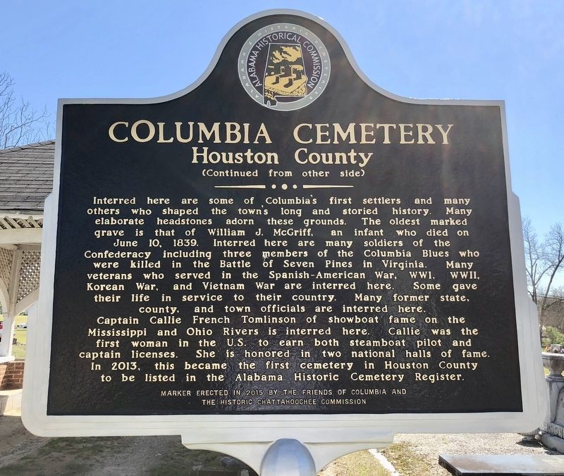
Near West Church Street west of North Washington Street.
Front
The Columbia Cemetery was started in the 1830s on land given
by Rev. Edmund Talbot. It postdates the abandoned Omussee
Creek Church Cemetery located a mile SW of here. A "public
Meeting house," which served as the Columbia . . . — — Map (db m115031) HM
On Main Street (Alabama Route 95) 0.1 miles north of Hall Street (County Road 81), on the left when traveling north.
(side 1)
Gordon Cemetery
Mr. William Wood (b. 22 Mar. 1826, d. 15 Oct. 1885), a prominent Gordon businessman, donated one acre of land located north of the town center adjacent to the old river road, now U.S. Highway 95, from . . . — — Map (db m73371) HM
On Alabama Route 605, 0.5 miles south of Boys Club Road, on the left when traveling south.
(side 1)
Big Creek United Methodist Church
One of the oldest churches in southeast Alabama and reportedly the oldest church in Houston County. The first church structure was a log building constructed about 20 yards north of the . . . — — Map (db m73356) HM
On Bellefonte Road (County Road 33) 0.8 miles east of Lee Highway/John T Reid Parkway (U.S. 72), on the left when traveling east.
(Front): Before the courthouse was completed, the community selected a location for a cemetery. The highest elevation in Bellefonte's corporate limits was chosen as the town's burial place. The earliest inscribed marker in Bellefonte Cemetery . . . — — Map (db m83790) HM
Near Alabama Route 42, 0.2 miles north of Alabama Route 36, on the right when traveling north.
A historically significant 19th century burial site, the Old Baptist Cemetery is located in Hollywood, Alabama, in the area formerly known as the Mud Creek Primitive Baptist Church. The cemetery is named for the oldest documented Baptist church in . . . — — Map (db m166946) HM
Near Veterans Drive (Alabama Route 35) north of Lee Highway (U.S. 72), on the right when traveling north.
Robert T. Scott, born in 1800 into a prominent North Carolina family who originally settled in Maryland, founded the Alabama town that bears his name. Between 1848 and 1858, he acquired 1,240 acres of choice land in the heart of Jackson County. . . . — — Map (db m166957) HM
On 14th Street South (State Highway 150) south of Fairfax Avenue, on the right when traveling south.
In 1840 he published his study, History of Rise and Progress of the Baptists in Alabama.
Also an evangelist and missionary.
In 1818 moved to Alabama from Carolinas, organizing five churches in vicinity.
President of Alabama Baptist . . . — — Map (db m27025) HM
On County Road 18, on the left when traveling west.
Union Baptist Church was organized in 1834 by 18 or 20 members from Canaan Church. The Libscomb area was then known as East End. Members of the Rockett and Ware families donated the original two acreas of this site and a log cabin, which served as . . . — — Map (db m24352) HM
Near Messer Airport Highway at University Avenue, on the right when traveling north.
This cemetery is the final resting place of three of the four young girls killed in the September 15, 1963 church bombing of the 16th Street Baptist Church. Addie Mae Collins, Cynthia Wesley and Carol Robertson are buried here. The fourth victim, . . . — — Map (db m61197) HM
In memory of the
Pioneers
many of whom sleep in this saved spot and whose vision, courage, and arduous labor have been abundantly rewarded by the wonderful development of this great city and district
This Chapel is erected by . . . — — Map (db m206426) HM
On Cahaba Road at Park Lane, on the right when traveling north on Cahaba Road.
In 1822 William Pullen, Revolutionary War veteran, acquired this land from the Federal Government for farming. In 1889 his heirs sold the land to the City of Birmingham for use as the New Southside Cemetery which operated from 1889 to 1909 with . . . — — Map (db m27096) HM
On Grantswood Road, on the right when traveling east.
New Hope Baptist Church and Cemetery were established here on land with a log house donated by Mr. & Mrs. Andrew Jackson Glass on August 21, 1884, for religious and educational purposes. The five-member church began with trustee Manson Glass. On . . . — — Map (db m83832) HM
On Martin Luther King Drive, on the right when traveling south.
(front): United Confederate Veterans Camp Hardee No. 39 Camp Hardee No. 39 was organized as a camp of the United Confederate Veterans on August 7, 1891. This cemetery plot was acquired by the camp to provide a final resting place for the men . . . — — Map (db m12487) HM
On Cumberland Drive at Balcourt Drive, on the right when traveling east on Cumberland Drive.
Wilson Chapel was built in 1916 as a memorial to James and Frances Wilson by their daughters, Rosa Wilson Eubanks and Minerva Wilson Constantine. At the time of its construction the area was developing into a community of country homes known as . . . — — Map (db m26681) HM
On Tarrant Huffman Road at Marshall Avenue, on the left when traveling west on Tarrant Huffman Road.
Mt. Zion Baptist Church began burying here in the mid-1800s. On June 2, 1970, New Grace Hill Cemetery, Inc., a subsidiary of the Booker T. Washington Insurance Company in Birmingham, purchased this cemetery and officially named it Zion Memorial . . . — — Map (db m35602) HM
Near 19th Street North north of 11th Avenue North, on the left when traveling north.
Son of a Swedish ironmaster, Linn built Birmingham's first industry, Birmingham Car & Foundry Company (Linn Iron Works); the first bank, The National Bank of Birmingham; and the City's first park, called Linn Park.
When the population was less . . . — — Map (db m216140) HM
On Clay-Palmerdale Road at Old Springville Road, on the right when traveling north on Clay-Palmerdale Road.
Local Methodist connections for Clay Methodist Church were Cedar Mountain Church and Shiloh Methodist Church. Samuel, a Revolutionary War soldier, was a notable member of these early churches. Many of his descendants are buried here. James Self . . . — — Map (db m117209) HM
On Cedar Mountain Road, on the right when traveling west.
The oldest marked grave is that of Nancy Paerson, daughter of William S. Turner who was born September 23, 1813 and died September 19, 1830. Jesse Taylor deeded land for this church and graveyard on February 15, 1856.
Listed in the Alabama . . . — — Map (db m25134) HM
Samuel Massey and his brother - in - law, Duke William Glenn, first came to this Territory in February 1814 with Lt. Col Reuben Nash's Regt. South Carolina Volunteer Militia to help defeat the Creek Indians in the War of 1812. Samuel Massey returned . . . — — Map (db m25088) HM
On Old Springville Road / County Road 30, on the left when traveling north.
Established about 1850, Wear Cemetery is located off Old Springville Road to the northeast at Countryside Circle. In the 1800's the Wear family was among the first settlers of the community later known as Clay. Twenty-three remaining graves were . . . — — Map (db m25113) HM
On Hollywood Boulevard east of Malaga Avenue, on the left when traveling east.
Union Hill Cemetery is the burial ground of many pioneers and early settlers of the Shades Valley area. It was established in the 1870s, but includes gravestones dating back to the early 1850s due to the relocation of two earlier, smaller cemeteries . . . — — Map (db m83873) HM
On Hollywood Blvd at Union Hill Drive, on the left when traveling east on Hollywood Blvd.
This cemetery is the final resting place of many of Shades Valley's pioneer residents. A few of the earliest headstones date from the mid-1850s. Descendants of these settlers helped mold the cities of Mountain Brook and Homewood. Located on property . . . — — Map (db m26294) HM
On Patton Chapel Road west of Montgomery Highway (U.S. 31), on the right when traveling west.
Just after the War Between the States Robert Berry Patton gave seven acres of land, logs from his sawmill to build a church, school and cemetery. He served as the first pastor. Fire destroyed the church in 1908 and 1938. The school served the area . . . — — Map (db m83915) HM
On Allison-Bonnett Memorial Drive at Tin Mill Road, on the right when traveling west on Allison-Bonnett Memorial Drive.
The original founders and charter members of Bethlehem Methodist Church are buried in this cemetery, consisting of benefactors, constructors, architects, soldiers, preachers and evangelists. Included are Ebenezer Hearn (1794-1862), James Rutledge . . . — — Map (db m215907) HM
Near Eastern Valley Road (State Road 119), on the right when traveling east.
In April 1836, William White donated land for a church and cemetery. In December 1904, William T. Simmons and his wife R. A. sold adjoining land to the church adding to the cemetery. The oldest marked grave is for Hepsey Herring who died October 8, . . . — — Map (db m83917) HM
On Ashville Road Northeast at Morgan Street Northeast, on the right when traveling west on Ashville Road Northeast.
Shiloh Cemetery is the first recorded Cumberland Presbyterian Cemetery in middle Alabama. Burial at Shiloh began in 1820, a year before the Shiloh Cumberland Presbyterian Church organized in 1821 at Oakridge, now Leeds. The cemetery stood back from . . . — — Map (db m49350) HM
On Mount Olive Road, 0.3 miles north of Whitten Road, on the right when traveling north.
The Graham Cemetery contains approximately 155 marked burials, with the earliest dating back to 1880. Buried in the cemetery are members of the Graham family, some of the first settlers of the area. Thomas Graham purchased 40 acres of land
in the . . . — — Map (db m173408) HM
On Port Birmingham Rd (State Highway 269) at Finland Road, on the right when traveling west on Port Birmingham Rd.
This cemetery is owned by St. John Baptist Church in Edgewater and operated by Scott-McPherson Funeral Home, Inc. US Steel Corporation previously owned the area and it is historically associated with the Edgewater Mining Camp community established . . . — — Map (db m37221) HM
On Gadsden Highway, 0.1 miles east of Calumet Parkway, on the right when traveling east.
This cemetery is named for the nearby Montneba Presbyterian Church, or Mt. Nebo, which was originally established on October 2, 1867, as the Presbytery of Springville Synod. On October 25, 1958, this church was renamed First Presbyterian Church of . . . — — Map (db m217759) HM
On Lee Highway (U.S. 72) 0.7 miles west of County Road 583, on the left when traveling west.
Daniel White, native of North Carolina, purchased land here in 1818, a year before Alabama became a state. His home and stagecoach stop, "Wayside Inn" was a large two~ story log house located on the North side of the highway from this site. In 1834 . . . — — Map (db m29170) HM
The notorious outlaw gang leader who boasted that no one would ever run over Tom Clark lies buried near the center of Tennessee Street where now all who pass by do run over him. In 1872, Clark, who terrorized helpless citizens during the Civil War, . . . — — Map (db m80320) HM
On East College Street, on the right when traveling east.
When the city was surveyed this land described as "outside the city limits" was designated as the burying grounds for the new town. It contains the graves of early settlers, including a son and brother of Ferdinand Sannoner, Surveyor of Florence, . . . — — Map (db m83968) HM
McVay (1766~1851), South Carolina native, built a three room log house at head of Cox's Creek about 1818. Community later called Mars Hill. He was a member of Mississippi Territorial Legislature, delegate to convention of 1819 which framed . . . — — Map (db m35260) HM
On Surveyor Road near Cloverdale Road (Alabama Route 157), on the left when traveling west.
Side 1:
To the south of this marker is the Hickory Hill Plantation Slave Cemetery which contains the remains of approximately 140 African-Americans. These individuals labored in the bonds of slavery during the period 1818 to 1865 and many . . . — — Map (db m138778) HM
On Surveyor Road, 0.2 miles west of Cloverdale Road, on the left when traveling west.
(side 1)
John Coffee was born in Prince Edward County, VA, in 1772, the son of Joshua and Elizabeth Graves Coffee. The family moved to NC in 1777. After his father died in 1798, Coffee and other family members moved to Davidson County, TN . . . — — Map (db m100248) HM WM
On County Route 34, 0.1 miles south of County Route 94, on the right when traveling south.
In 1824, settlers from the Carolinas built Old Pleasant Grove Primitive Baptist Church, the first church in the Cowpen Creek area and one of the earliest churches in Lauderdale County. Although the cemetery was likely established before the church . . . — — Map (db m236490) HM
On Wildwood Park Road at Waterloo Road on Wildwood Park Road.
Side 1 Following an outbreak of the dreaded plague, smallpox (Variola), at Florence during the winter of 1865-66, the Board of Alderman adopted a resolution on January 2, 1866, that a Pesthouse be “erected at the vineyard as soon as . . . — — Map (db m84043) HM
On County Road 222 west of County Road 231, on the right when traveling west.
The first marked grave here is that of David Reeder who died November 14, 1843. An earlier unmarked burial was a Mrs. McClure from Ireland. The original log church and school stood just north of the cemetery. In 1884, a new church was erected north . . . — — Map (db m156987) HM
On South Magnolia Street, on the right when traveling north.
This area is the military cemetery for Confederate Soldiers. After an 1862 skirmish in the streets of Florence, it was used to bury casualties until the end of the Civil War. Many unknown Confederates and a few unknown Union soldiers rest here. . . . — — Map (db m28402) HM
Church organized in 1819; First Cemetery Burial in 1819. One of the earliest Methodist Congregations in the area, this church was organized by local preacher, Rev. Alexander Faires, in a log school built in 1816. Land donated in 1818 for church and . . . — — Map (db m56354) HM
Side A
In 1818 three Wilson brothers John, Matthew and Samuel, came from Virginia to purchase large farms in this area. The plantations of John and Matthew joined near this cemetery. All three brothers and their families are buried here. . . . — — Map (db m28160) HM
On County Road 47 at County Road 140, on the left when traveling north on County Road 47.
This is one of the earliest community burial grounds in Lauderdale County. The oldest dated gravestone is for Catherine Hill, first wife of Green Berry Hill, for whom the community is named. She died on June 8, 1825. George Kennedy deeded five acres . . . — — Map (db m154332) HM
On Alabama Route 64 at County Road 89, on the right when traveling west on State Route 64.
Established in 1894 as New Salem Presbyterian Church. Originally affiliated with the Cumberland Presbyterian Church, the first recorded meeting was held 1897, William White, Pastor.
The Church became affiliated with Presbyterian U.S.A. in 1907. . . . — — Map (db m86305) HM
On County Road 568 at County Road 51, on the left when traveling west on County Road 568.
The home-place of Bettie Anne Springer-Thornton lies 1.6 miles north on the east side of Lauderdale County Road 51. This home was originally a one-room log cabin, built between 1892 and 1894 by Levi Patrick Thornton. Two rooms and a dog-trot were . . . — — Map (db m141966) HM
Gabriel Butler “Ole Gabe” was born in the Carolinas in 1779, about the time of the Revolutionary War. His name is on records in Kentucky in the 1800s. He married his first wife, Sarah Whitesides, in Warren County, KY, on December 26, 1803. Gabe . . . — — Map (db m216372) HM
On Van Buren Street, 0.1 miles north of Jefferson Street.
Side A
One of Alabama's oldest and most picturesque town cemeteries, this site was set aside as a burying ground by the Courtland Land Company in its original survey made prior to the incorporation of the town in 1819. Many of the area's . . . — — Map (db m84304) HM
On Court Street (County Route 460) 0.3 miles west of Alabama Route 157, on the right when traveling west.
First known as the Peerson Cemetery, it later became the McKelvey Cemetery and still carries that name. Buried here are some early Moulton pioneers and merchants, Veterans of the War of 1812 and Civil War, each contributed to Moulton's early . . . — — Map (db m84312) HM
On County Road 448, 0.1 miles west of County Road 23, on the right when traveling south.
Ca. 1875-1947. Faith healer. Fortune teller and finder of lost things. His yard filled every Sunday with seekers from near and far. Buried here. — — Map (db m239806) HM
Copena Indians built this mound with baskets of dirt some 2000 years ago. The Copena name was derived from their use of copper and galena (lead ore) found in their burials along with gorgets and celts. The mounds were a burial site with the dead . . . — — Map (db m84315) HM
On South Dean Road at East Thach Avenue, on the right when traveling north on South Dean Road.
(Side 1)
Auburn's first separate black community cemetery offers a rich source of the city’s black heritage. Much of the history is oral but it is known that a white man gave most of the land in the early 1870’s. The four acre cemetery . . . — — Map (db m74453) HM
On Armstrong Street at Miller Avenue, on the right when traveling north on Armstrong Street.
(Side 1)
Pine Hill was established in 1837 and is the oldest cemetery in Auburn. Judge John J. Harper, Auburn's founder, donated almost six acres to the new town to be used as a community burying ground for white settlers and their . . . — — Map (db m74474) HM
On Long Street at Auburn Street, on the left when traveling north on Long Street.
Side 1
On February 9, 1876, the City of Opelika paid D.B. Preston $80 for two acres of land to establish an African-American section of Rosemere Cemetery. This rectangular area of the cemetery contains 176 blocks, with 16 being partial . . . — — Map (db m75139) HM
On Long Street, 0.1 miles north of Auburn Street, on the left when traveling north.
Side 1
The City of Opelika purchased 19.6 acres of land to expand Rosemere Cemetery. This rectangular area is the newest portion. There are 193 blocks with varying numbers of sections and spaces in each. 467 grave markers have death dates . . . — — Map (db m75140) HM
Near Long Street, 0.2 miles north of Auburn Street, on the right when traveling north.
Side 1
On July 23, 1869, the City of Opelika purchased ten acres of land for a cemetery from Dr. A.B. Bennett for $100 an acre. On November 23, 1869, he accepted his choice of a lot in exchange for the debt. The earliest marked grave is . . . — — Map (db m85335) HM
On Cambridge Lane (County Road 93) 0.6 miles south of U.S. 72, on the left when traveling south.
North Side This marks the site of Cambridge, a small town established in the earliest years of Limestone County. In 1818, it consisted of several business houses, shops, and a mill. It was one of three locations considered for the county . . . — — Map (db m60177) HM
On 4th Street at Grace Avenue, on the right when traveling west on 4th Street.
Wealthy and influential Virginia family settled here in 1820's. Daniel Coleman (1801-1857) built his stately home a block west about 1826. During the Civil War, home was occupied by Yankee troops who took Elizabeth Coleman's teeth for their gold . . . — — Map (db m85389) HM
Near East Hobbs Street west of Thomas Street, on the left when traveling west.
The Confederate Circle in Athens City Cemetery contains graves of over 50 soldiers killed in or around Athens during the WBTS, 8 unknown. Around 1898 ladies of the local UDC were working in the cemetery when bones, believed to be soldiers, were . . . — — Map (db m94159) HM
This burial mound is one of hundreds constructed during the Middle Woodland period between 100 BC and AD 500 by native people who shared burial practices with other similar cultural groups extending from the Gulf and Atlantic coasts to Canada. . . . — — Map (db m154232) HM
On Lentzville Road, 0.7 miles south of Barker Road, on the right when traveling south.
Lentzville Cemetery began as the family cemetery for the family of John Henry Lentz (7 Feb 1753-18 Jul 1835) and his wife Savilla. John Henry was a veteran of the American Revolution and pioneer settler of Limestone County, entering his land in . . . — — Map (db m114306) HM
On East Washington Street west of East Street, on the right when traveling west.
This is the earliest known cemetery in the town of Athens, and the final resting place for many of its first citizens. The earliest burials date from the 1820’s and continue through the mid-1800’s, with an occasional burial past 1900. Through the . . . — — Map (db m71525) HM
On New Garden Road at New Garden Road (County Route 98), on the right when traveling south on New Garden Road.
(Side A)
Old New Garden Cemetery
This cemetery is one of the oldest in Limestone County and is listed on the Alabama Historic Cemetery Register. Many of the areas earliest settlers are buried here including Patsy Elmore, widow of a . . . — — Map (db m73836) HM
Near Oakwood Lane at Old Highway 20, on the left when traveling south.
VA native John Nelson Spotswood Jones, son of Rev. War Capt. Lewellen Jones, cousin of Martha Washington, and descendant of Rev. Rowland Jones of Williamsburg's Bruton Parish, built Druid's Grove near this site before 1820 and established the . . . — — Map (db m70235) HM
On Buck Island Road (State Highway 99) north of Sugar Way, on the left when traveling south.
Approximately 200 yards east of this site are the unmarked graves of Abner Alloway Strange, Sr., and other family members. (The markers were moved to Salem Methodist Cemetery in 1977.) A Sergeant in the Virginia Militia, Strange was at Yorktown . . . — — Map (db m32561) HM
On Dupree Hollow Road (County Route 37) 0.5 miles south of Easter Ferry Road (County Route 104), on the left when traveling south.
The first known burial here is Charles Cunningham who died September 28, 1852. Many unmarked fieldstones are present that could mark older graves. The cemetery contains 82 identifiable burials with headstones. Six Confederate soldiers, WWI, and WWII . . . — — Map (db m98753) HM
Near Dupree Hollow Road (County Route 37) 1.4 miles north of Buck Island Road (Alabama Route 99), on the left when traveling north.
The first known burial here is Nancy Vinson Christopher who died May 16, 1852. Many unmarked fieldstones are present that could mark older graves. The cemetery contains 52 identifiable burials with headstones. Five Confederate soldiers and one WWII . . . — — Map (db m71991) HM
Side A
Build abt. 1858 by Schuyler Harris on land once owned by Henry Augustine Washington, a distant relative of the first president. Through purchases, marriages, and inheritance between the Washington, Harris and Pryor families, all . . . — — Map (db m85458) HM
On South Broad Street (County Road 29) at Cross Lane, on the right when traveling north on South Broad Street.
Frances Lewis II (1768-1837), a planter, was the first soul to
be interred in this family cemetery. Lewis was born a British
subject in the Colony of Virginia and migrated to Alabama in
the 1820s. The fathers of both Frances Lewis II and his . . . — — Map (db m245991) HM
Near North Broad Street, 1.5 miles north of U.S. 80, on the right when traveling north.
In Honor of
Our Confederate Soldiers
1861 1865
Jno Alexander • Wm. Alexander • Wm. H. Alexander • Ed Alexander • Capt. M.F. Bonham • Maj. Bright • Capt. T.B. Brown • Alberta Caffee • Irvin Crocheron • J.P. Caffee • Jim Crocheron • Jno. . . . — — Map (db m85472) WM
Near Slim Road, 0.3 miles south of County Road 10, on the right when traveling south.
Creek Stand's earliest African-American pioneers and their descendants are buried here. Oral history indicates that many slaves were buried here generations before the original church was constructed in 1895. These ancestors came to Macon County . . . — — Map (db m227725) HM
On County Road 10, 0.2 miles west of County Road 79, on the left when traveling north.
Creek Stand Methodist Church
and Historic Cemetery
dating back to about 1850
The original church was dismantled and reconstructed with same material in smaller size during the year 1951 — — Map (db m188777) HM
On U.S. 29, 0.1 miles north of County Route 2, on the right when traveling north.
Elizabeth Missionary Baptist Church is one of the oldest Black Missionary Baptist Churches in Macon County. The church was organized in 1860 under the leadership of Rev. M. Eley and the Tuskegee Baptist Association. Between 1860 and 1876, Elizabeth . . . — — Map (db m205266) HM
On Union Camp Road, 0.2 miles north of Cooper Lane, on the right when traveling north.
The camp on this site served as a military hospital, a camp of conscription and instruction, a supply depot, and a cemetery during the War Between the States. At one time, there were hundreds of headstones and rocks marking the final resting place . . . — — Map (db m73529) HM
On Alabama Route 81 south of Pistol Range Road, on the right.
Oldest Identified Grave Site: 1881.
Grave sites include participants of the
U.S. Public Health Study of Syphilis in
Untreated Black Males, 1930-1972.
Designated State of Alabama Historic Site: 2006 — — Map (db m151227) HM
On County Route 43, 0.1 miles north of County Route 24, on the right when traveling north.
This cemetery was founded in 1900 when Francis Marion Whatley and Emma Whatley buried their daughter, Ophelia. A son of Simeon Whatley, Francis was a Confederate prisoner of war veteran. He was a prominent landowner, farmer, and cotton gin and . . . — — Map (db m204230) HM
On Booker T Washington Boulevard, 0.1 miles south of Frederick D. Patterson Drive, on the right when traveling south.
More than 8,000 people, White and Colored, rich and poor, from the lowliest farm and the richest Fifth Avenue mansion crowded in and around the school chapel to pay homage [to Booker T. Washington].
—Baltimore . . . — — Map (db m99943) HM
On Meridianville Bottom Road, 0.1 miles south of Bolling Road, on the right when traveling north.
This unmarked cemetery site was discovered during the relocation of a section of Meridianville Bottom Road in July 2012. Though no marked graves are present, this might be a family graveyard associated with the early settlers of Madison County. . . . — — Map (db m154283) HM
On Cemetery Street Northwest at Hall Avenue Northwest, in the median on Cemetery Street Northwest.
Glenwood Cemetery replaced the original slave cemetery, known as "Georgia,” which had been established in 1818 and located north of the present Huntsville Hospital. Glenwood Cemetery was established in 1870 by the City of Huntsville following . . . — — Map (db m154245) HM
On Moores Mill Road at Old Gurley Road NE, on the left when traveling south on Moores Mill Road.
Harris Hill Cemetery is located Sec. 17, T3, and R1E, on the south side of Highway 72 East at the intersection of Moores Mill Road and Highway 72 East in a large clump of trees on a small rise. This is the old home place and family graveyard of . . . — — Map (db m43878) HM
Near Maple Hill Street Southeast at Eustis Ave SE.
Born in Virginia; graduate of Princeton; lawyer, planter, and politician. President of the Alabama Constitutional Convention held July 5-Aug 2, 1819 in what is now Huntsville; 1 of 8 signers from Madison County; and 1 of 44 delegates from 22 . . . — — Map (db m235545) HM
On Wells Avenue SE at Maple Hill Street SE on Wells Avenue SE.
(side 1)
Established 1818
by the City of Huntsville
Maple Hill Cemetery
has become the final resting place of many citizens of this community. Here lie brave men who served in the major wars of our nation, many public servants, . . . — — Map (db m28791) HM
On Madison Street at St. Clair Avenue, on the right when traveling south on Madison Street.
On September 3, 1818, the Huntsville City Commissioners purchased two acres of land from LeRoy Pope for a "burying ground" for slaves. This cemetery was located within the NE quarter of Section 1, Township 4, Range 1 West of the Base Meridian. It . . . — — Map (db m35214) HM
On Liberty Lane near H.L. Cleveland Way, in the median.
This cemetery site was used as a burial ground for slaves who lived on both the Peter Blow and Job Key plantations from 1811 to 1865. Dred Scott's first wife and their two children are believed to have been buried here. The cemetery continued to be . . . — — Map (db m31562) HM
On Maple Hill Street Southeast at Eustis Ave SE, on the left when traveling west on Maple Hill Street Southeast.
Born in Virginia; attorney, judge, and planter. Chair of Committee of Fifteen that drafted the 1st Alabama Constitution during Convention held July 5-Aug 2, 1819 in what is now Huntsville; 1 of 8 signers from Madison County; and 1 of 44 delegates . . . — — Map (db m235535) HM
Near Maple Hill Street Southeast near Eustis Ave SE.
Born in Virginia; prominent in business, finance, and politics. 1 of 3 signers from Limestone County at 1st Alabama Constitutional Convention held July 5- Aug. 2, 1819 in what is now Huntsville; 1 of 44 delegates from 22 counties. The Alabama . . . — — Map (db m235540) HM
Near Maple Hill Street Southeast at Eustis Ave SE.
(Succeeded His Brother William Wyatt Bibb, H.D., as Governor
Delegate, Alabama, Constitution Convention 1819
Representative, Alabama State Legislature
President, First Alabama State Senate
— — Map (db m235541) HM
On Maple Street south of Mille Road, on the left when traveling south.
Listed on the Alabama Historic Cemetery Register in 2015 by the Alabama Historical Commission. This plot of ground has been the resting place of many of Madison's pioneer families since the early 1800s. This marker is erected to remember and honor . . . — — Map (db m191687) HM
On Keel Hollow Road, 0.1 miles north of Cherry Tree Road (County Route 28), on the left when traveling north.
(front)
On October 11, 1823, Bethel Church joined the MUD Creek Association of Primitive Baptist Churches. Frank P. and Nannie Butler Ivy deeded Bethel Cemetery to Bethel Church on May 25, 1891. On June 5, 1982 the Bethe Cemetery Perpetual . . . — — Map (db m126816) HM
On Hayden Cemetery Road, 0.1 miles west of Poplar Ridge Road, on the left when traveling west.
On August 19, 1887, Tranquilla J. Haden gave to
the Poplar Ridge community 1.5 acres at this
site for a cemetery later to be called Hayden.
The site had been used as a cemetery since
as early as 1858. The cemetery expanded to 5.1
acres through . . . — — Map (db m191685) HM
10944 entries matched your criteria. Entries 101 through 200 are listed above. ⊲ Previous 100 — Next 100 ⊳