10986 entries match your criteria. Entries 101 through 200 are listed.⊲ Previous 100 — Next 100 ⊳
Cemeteries & Burial Sites Topic
By Mark Hilton, March 14, 2018
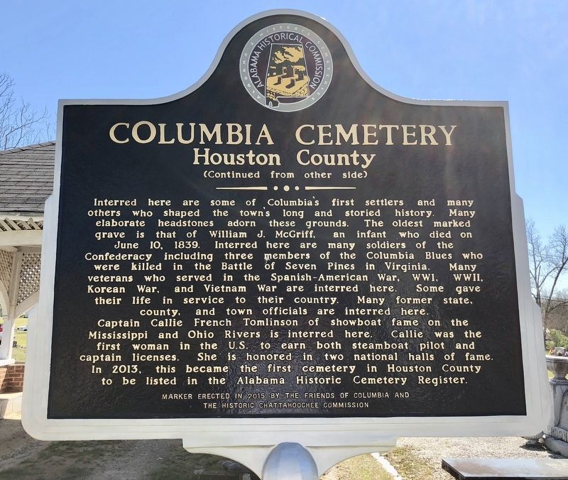
Columbia Cemetery Marker (rear)
| 101 ► Alabama, Houston County, Columbia — Columbia Cemetery — Houston County — |
| Near West Church Street west of North Washington Street. | |||
| 102 ► Alabama, Houston County, Gordon — Gordon Cemetery / Early Gordon Leaders — |
| On Main Street (Alabama Route 95) 0.1 miles north of Hall Street (County Road 81), on the left when traveling north. | |||
| 103 ► Alabama, Houston County, Rehobeth — Big Creek United Methodist Church / Joseph Watford Revolutionary War Veteran — |
| On Alabama Route 605, 0.5 miles south of Boys Club Road, on the left when traveling south. | |||
| 104 ► Alabama, Jackson County, Hollywood — Bellefonte Cemetery / Town of Bellefonte — |
| On Bellefonte Road (County Road 33) 0.8 miles east of Lee Highway/John T Reid Parkway (U.S. 72), on the left when traveling east. | |||
| 105 ► Alabama, Jackson County, Hollywood — Old Baptist Cemetery — Jackson County — |
| Near Alabama Route 42, 0.2 miles north of Alabama Route 36, on the right when traveling north. | |||
| 106 ► Alabama, Jackson County, Scottsboro — Robert Thomas Scott, Sr. — Scottsboro Founder / Successful Pioneer — |
| Near Veterans Drive (Alabama Route 35) north of Lee Highway (U.S. 72), on the right when traveling north. | |||
| 107 ► Alabama, Jefferson County, Bessemer — Hosea Holcombe — 1780-1841 — "Alabama's first church historian" — |
| On 14th Street South (State Highway 150) south of Fairfax Avenue, on the right when traveling south. | |||
| 108 ► Alabama, Jefferson County, Bessemer — Union Baptist Church And Cemetery — |
| On County Road 18, on the left when traveling west. | |||
| 109 ► Alabama, Jefferson County, Birmingham — 1963 Church Bombing Victims — |
| Near Messer Airport Highway at University Avenue, on the right when traveling north. | |||
| 110 ► Alabama, Jefferson County, Birmingham — Forrest Camp No. 1435 — |
| On 60th Street North, in the median. | |||
| 111 ► Alabama, Jefferson County, Birmingham — In Memory of the Pioneers — |
| Near 19th Street North. | |||
| 112 ► Alabama, Jefferson County, Birmingham — Lane Park — |
| On Cahaba Road at Park Lane, on the right when traveling north on Cahaba Road. | |||
| 113 ► Alabama, Jefferson County, Birmingham — New Hope Cemetery — Jefferson County — |
| On Grantswood Road, on the right when traveling east. | |||
| 114 ► Alabama, Jefferson County, Birmingham — Oak Hill Cemetery — 1871 – 1971 — D A R — |
| Near 19th Street North. | |||
| 115 ► Alabama, Jefferson County, Birmingham — United Confederate Veterans — |
| On 60th Street North, in the median. | |||
| 116 ► Alabama, Jefferson County, Birmingham — United Confederate Veterans — Camp Hardee No. 39 — |
| On Martin Luther King Drive, on the right when traveling south. | |||
| 117 ► Alabama, Jefferson County, Birmingham — Wilson Chapel And Cemetery — ("The Little Brown Church in the Wildwood") — |
| On Cumberland Drive at Balcourt Drive, on the right when traveling east on Cumberland Drive. | |||
| 118 ► Alabama, Jefferson County, Birmingham — Zion Memorial Gardens — |
| On Tarrant Huffman Road at Marshall Avenue, on the left when traveling west on Tarrant Huffman Road. | |||
| 119 ► Alabama, Jefferson County, Birmingham, Fountain Heights — Capt. Charles Linn — (1814-1882) — |
| Near 19th Street North north of 11th Avenue North, on the left when traveling north. | |||
| 120 ► Alabama, Jefferson County, Clay — Clay Methodist Cemetery — Jefferson County — |
| On Clay-Palmerdale Road at Old Springville Road, on the right when traveling north on Clay-Palmerdale Road. | |||
| 121 ► Alabama, Jefferson County, Clay — Mount Calvary Cemetery — Clay, Alabama — formerly Ayers, Alabama — |
| On Cedar Mountain Road, on the right when traveling west. | |||
| 122 ► Alabama, Jefferson County, Clay — Pioneer Massey Cemetery — |
| Near Advent Circle. | |||
| 123 ► Alabama, Jefferson County, Clay — Wear Cemetery — |
| On Old Springville Road / County Road 30, on the left when traveling north. | |||
| 124 ► Alabama, Jefferson County, Homewood — Union Hill Cemetery — |
| On Hollywood Boulevard east of Malaga Avenue, on the left when traveling east. | |||
| 125 ► Alabama, Jefferson County, Homewood — Union Hill Cemetery, Union Hill Methodist Episcopal Church, Union Hill School — |
| On Hollywood Blvd at Union Hill Drive, on the left when traveling east on Hollywood Blvd. | |||
| 126 ► Alabama, Jefferson County, Hoover — Patton Chapel Church 1866 — |
| On Patton Chapel Road west of Montgomery Highway (U.S. 31), on the right when traveling west. | |||
| 127 ► Alabama, Jefferson County, Hueytown, Dolomite — Bethlehem Church Cemetery — |
| On Allison-Bonnett Memorial Drive at Tin Mill Road, on the right when traveling west on Allison-Bonnett Memorial Drive. | |||
| 128 ► Alabama, Jefferson County, Leeds — Mt. Hebron Cemetery — Jefferson County — |
| Near Eastern Valley Road (State Road 119), on the right when traveling east. | |||
| 129 ► Alabama, Jefferson County, Leeds — Shiloh Cemetery — Established Circa 1820 — |
| On Ashville Road Northeast at Morgan Street Northeast, on the right when traveling west on Ashville Road Northeast. | |||
| 130 ► Alabama, Jefferson County, Mount Olive — Graham Cemetery — |
| On Mount Olive Road, 0.3 miles north of Whitten Road, on the right when traveling north. | |||
| 131 ► Alabama, Jefferson County, Mulga — Historic Lakeview Cemetery — |
| On Port Birmingham Rd (State Highway 269) at Finland Road, on the right when traveling west on Port Birmingham Rd. | |||
| 132 ► Alabama, Jefferson County, Trussville — Mt. Nebo Cemetery — Jefferson County — |
| On Gadsden Highway, 0.1 miles east of Calumet Parkway, on the right when traveling east. | |||
| 133 ► Alabama, Lauderdale County, Elgin — Daniel White — Settled Here in 1818 — |
| On Lee Highway (U.S. 72) 0.7 miles west of County Road 583, on the left when traveling west. | |||
| 134 ► Alabama, Lauderdale County, Florence — "Mountain" Tom Clark — Hanged September 4, 1872 — |
| On Tennessee Street. | |||
| 135 ► Alabama, Lauderdale County, Florence — Florence Cemetery — -1818- — |
| On East College Street, on the right when traveling east. | |||
| 136 ► Alabama, Lauderdale County, Florence — Governor Hugh McVay Home Site and Cemetery — |
| On N. Cox Creek Parkway. | |||
| 137 ► Alabama, Lauderdale County, Florence — Hickory Hill Plantation Slave Cemetery — |
| On Surveyor Road near Cloverdale Road (Alabama Route 157), on the left when traveling west. | |||
| 138 ► Alabama, Lauderdale County, Florence — John Coffee: 1772-1833 — |
| On Surveyor Road, 0.2 miles west of Cloverdale Road, on the left when traveling west. | |||
| 139 ► Alabama, Lauderdale County, Florence — Old Pleasant Grove Primitive Baptist Church & Cemetery — Lauderdale County — |
| On County Route 34, 0.1 miles south of County Route 94, on the right when traveling south. | |||
| 140 ► Alabama, Lauderdale County, Florence — Pesthouse and Cemetery / Pestilences — 1866 / "Prior to 20th Century" — |
| On Wildwood Park Road at Waterloo Road on Wildwood Park Road. | |||
| 141 ► Alabama, Lauderdale County, Florence — Pleasant Hill United Methodist Church Cemetery — — Established prior to 1843 — — |
| On County Road 222 west of County Road 231, on the right when traveling west. | |||
| 142 ► Alabama, Lauderdale County, Florence — Soldier's Rest — -1862- — |
| On South Magnolia Street, on the right when traveling north. | |||
| 143 ► Alabama, Lauderdale County, Florence — Wesley Chapel United Methodist Church and Cemetery — Church Organized 1818: — First Cemetery Burial 1819 — |
| On County Road 15. | |||
| 144 ► Alabama, Lauderdale County, Florence — Wilson Family Cemetery 19th Century / Slave Cemetery 19th Century — |
| On Plantation Springs Drive. | |||
| 145 ► Alabama, Lauderdale County, Greenhill — Tabernacle Cemetery — Lauderdale County — |
| On County Road 47 at County Road 140, on the left when traveling north on County Road 47. | |||
| 146 ► Alabama, Lauderdale County, Lexington — Grassy Memorial Chapel and Cemetery — |
| On Alabama Route 64 at County Road 89, on the right when traveling west on State Route 64. | |||
| 147 ► Alabama, Lauderdale County, Rogersville — Bettie Anne Highway — |
| On County Road 568 at County Road 51, on the left when traveling west on County Road 568. | |||
| 148 ► Alabama, Lauderdale County, Rogersville — Gabriel “Old Gabe” Butler — 1779~1856 — |
| On CR 421. | |||
| 149 ► Alabama, Lawrence County, Courtland — Courtland Cemetery — -1819- — |
| On Van Buren Street, 0.1 miles north of Jefferson Street. | |||
| 150 ► Alabama, Lawrence County, Moulton — Peerson/McKelvey Cemetery — |
| On Court Street (County Route 460) 0.3 miles west of Alabama Route 157, on the right when traveling west. | |||
| 151 ► Alabama, Lawrence County, Mount Hope — 150 — Lawson Hubbard — Legends & Lore — |
| On County Road 448, 0.1 miles west of County Road 23, on the right when traveling south. | |||
| 152 ► Alabama, Lawrence County, Oakville — Copena Burial Mound — |
| On County Route 187. | |||
| 153 ► Alabama, Lee County, Auburn — Baptist Hill — |
| On South Dean Road at East Thach Avenue, on the right when traveling north on South Dean Road. | |||
| 154 ► Alabama, Lee County, Auburn — Pine Hill Cemetery — |
| On Armstrong Street at Miller Avenue, on the right when traveling north on Armstrong Street. | |||
| 155 ► Alabama, Lee County, Opelika — African-American Rosemere Cemetery — Lee County — |
| On Long Street at Auburn Street, on the left when traveling north on Long Street. | |||
| 156 ► Alabama, Lee County, Opelika — Lebanon Methodist Meeting House — |
| On Old Columbus Road at Edwards Road, on the left when traveling south on Old Columbus Road. | |||
| 157 ► Alabama, Lee County, Opelika — New Rosemere Cemetery — Lee County — |
| On Long Street, 0.1 miles north of Auburn Street, on the left when traveling north. | |||
| 158 ► Alabama, Lee County, Opelika — Old Rosemere Cemetery — Lee County — |
| Near Long Street, 0.2 miles north of Auburn Street, on the right when traveling north. | |||
| 159 ► Alabama, Limestone County, Athens — Cambridge — |
| On Cambridge Lane (County Road 93) 0.6 miles south of U.S. 72, on the left when traveling south. | |||
| 160 ► Alabama, Limestone County, Athens — Coleman Family — Coleman Hill — |
| On 4th Street at Grace Avenue, on the right when traveling west on 4th Street. | |||
| 161 ► Alabama, Limestone County, Athens — Confederate Circle — |
| Near East Hobbs Street west of Thomas Street, on the left when traveling west. | |||
| 162 ► Alabama, Limestone County, Athens — Copena Mound — |
| Near Bay Village Drive at Bay Hill Drive. | |||
| 163 ► Alabama, Limestone County, Athens — Lentzville Cemetery — |
| On Lentzville Road, 0.7 miles south of Barker Road, on the right when traveling south. | |||
| 164 ► Alabama, Limestone County, Athens — Old Town Cemetery — |
| On East Washington Street west of East Street, on the right when traveling west. | |||
| 165 ► Alabama, Limestone County, Elkmont — Old New Garden Cemetery / New Garden Cumberland Presbyterian Church — |
| On New Garden Road at New Garden Road (County Route 98), on the right when traveling south on New Garden Road. | |||
| 166 ► Alabama, Limestone County, Greenbrier — Druid's Grove Plantation / Jones-Donnell Cemetery — |
| Near Oakwood Lane at Old Highway 20, on the left when traveling south. | |||
| 167 ► Alabama, Limestone County, Salem — Abner Alloway Strange, Sr. — 1761-1835 — Veteran of the American Revolution — |
| On Buck Island Road (State Highway 99) north of Sugar Way, on the left when traveling south. | |||
| 168 ► Alabama, Limestone County, Salem — Cunningham Cemetery — Limestone County — |
| On Dupree Hollow Road (County Route 37) 0.5 miles south of Easter Ferry Road (County Route 104), on the left when traveling south. | |||
| 169 ► Alabama, Limestone County, Salem — Dupree Cemetery — Limestone County — |
| Near Dupree Hollow Road (County Route 37) 1.4 miles north of Buck Island Road (Alabama Route 99), on the left when traveling north. | |||
| 170 ► Alabama, Limestone County, Tanner — Harris-Pryor House — (Flower Hill Farm) — |
| On U.S. 31. | |||
| 171 ► Alabama, Lowndes County, Lowndesboro — Lewis-Smith Cemetery — 1837-1901 — Historic Site — |
| Near South Broad Street at Cross Lane, on the right when traveling north. | |||
| 172 ► Alabama, Lowndes County, Lowndesboro — Lewis-Smith Historic Cemetery — Lowndes County — |
| On South Broad Street (County Road 29) at Cross Lane, on the right when traveling north on South Broad Street. | |||
| 173 ► Alabama, Lowndes County, Lowndesboro — Our Confederate Soldiers — 1861 1865 — |
| Near North Broad Street, 1.5 miles north of U.S. 80, on the right when traveling north. | |||
| 174 ► Alabama, Macon County, Creek Stand — Creek Stand AME Zion Church Cemetery — Macon County — |
| Near Slim Road, 0.3 miles south of County Road 10, on the right when traveling south. | |||
| 175 ► Alabama, Macon County, Creek Stand — Creek Stand Methodist Church — |
| On County Road 10, 0.2 miles west of County Road 79, on the left when traveling north. | |||
| 176 ► Alabama, Macon County, Fort Davis — Elizabeth Missionary Baptist Church — Macon County — |
| On U.S. 29, 0.1 miles north of County Route 2, on the right when traveling north. | |||
| 177 ► Alabama, Macon County, Notasulga — Camp Watts — Named for Thomas H. Watts — CSA Attorney General (1862-63) and Alabama Governor (1863-65) — |
| On Union Camp Road, 0.2 miles north of Cooper Lane, on the right when traveling north. | |||
| 178 ► Alabama, Macon County, Notasulga — Shiloh Missionary Baptist Church Cemetery — |
| On Alabama Route 81 south of Pistol Range Road, on the right. | |||
| 179 ► Alabama, Macon County, Opelika — Francis Marion Whatley Cemetery — |
| On County Route 43, 0.1 miles north of County Route 24, on the right when traveling north. | |||
| 180 ► Alabama, Macon County, Tuskegee Institute — Tuskegee Cemetery — Tuskegee Institute National Historic Site — National Park Service, U.S. Department of the Interior — |
| On Booker T Washington Boulevard, 0.1 miles south of Frederick D. Patterson Drive, on the right when traveling south. | |||
| 181 ► Alabama, Madison County, Huntsville — David Peter Lewis — 24th Governor of Alabama — 1872 - 1874 — |
| On Maple Hill Street Southeast at Eustis Ave SE, on the left when traveling south on Maple Hill Street Southeast. | |||
| 182 ► Alabama, Madison County, Huntsville — Early Settlers Cemetery — Madison County — |
| On Meridianville Bottom Road, 0.1 miles south of Bolling Road, on the right when traveling north. | |||
| 183 ► Alabama, Madison County, Huntsville — Glenwood Cemetery — |
| On Cemetery Street Northwest at Hall Avenue Northwest, in the median on Cemetery Street Northwest. | |||
| 184 ► Alabama, Madison County, Huntsville — Harris Hill Cemetery — |
| On Moores Mill Road at Old Gurley Road NE, on the left when traveling south on Moores Mill Road. | |||
| 185 ► Alabama, Madison County, Huntsville — John Williams Walker — 200 Alabama Bicentennial — |
| Near Maple Hill Street Southeast at Eustis Ave SE. | |||
| 186 ► Alabama, Madison County, Huntsville — Maple Hill Cemetery — |
| On Wells Avenue SE at Maple Hill Street SE on Wells Avenue SE. | |||
| 187 ► Alabama, Madison County, Huntsville — Maple Hill Cemetery — Established 1818 — |
| On Maple Hill Street Southeast at Eustis Ave SE, on the right when traveling north on Maple Hill Street Southeast. | |||
| 188 ► Alabama, Madison County, Huntsville — Reuben Chapman — 13th Governor of Alabama — 1847 - 1849 — |
| Near Maple Hill Street Southeast at Eustis Ave SE. | |||
| 189 ► Alabama, Madison County, Huntsville — Robert Miller Patton — 20th Governor of Alabama — 1865 - 1867 — |
| On Maple Hill Street Southeast at Eustis Ave SE, on the right when traveling south on Maple Hill Street Southeast. | |||
| 190 ► Alabama, Madison County, Huntsville — Site of the Huntsville Slave Cemetery — |
| On Madison Street at St. Clair Avenue, on the right when traveling south on Madison Street. | |||
| 191 ► Alabama, Madison County, Huntsville — Slave Cemetery — 1800s — |
| On Liberty Lane near H.L. Cleveland Way, in the median. | |||
| 192 ► Alabama, Madison County, Huntsville, Five Points — Clement Comer Clay — 200 Alabama Bicentennial — |
| On Maple Hill Street Southeast at Eustis Ave SE, on the left when traveling west on Maple Hill Street Southeast. | |||
| 193 ► Alabama, Madison County, Huntsville, Five Points — Clement Comer Clay — 8th Governor of Alabama — 1835 - 1837 — |
| On Maple Hill Street Southeast at Eustis Ave SE, on the left when traveling west on Maple Hill Street Southeast. | |||
| 194 ► Alabama, Madison County, Huntsville, Five Points — Thomas Bibb — 200 Alabama Bicentennial — |
| Near Maple Hill Street Southeast near Eustis Ave SE. | |||
| 195 ► Alabama, Madison County, Huntsville, Five Points — Thomas Bibb — 2nd Governor of Alabama — 1820 - 1821 — |
| Near Maple Hill Street Southeast at Eustis Ave SE. | |||
| 196 ► Alabama, Madison County, Madison — James Henry Bibb — |
| On Bibb Street north of Mill Road, on the left when traveling north. | |||
| 197 ► Alabama, Madison County, Madison — Madison Cemetery — |
| Near Mill Road, 0.1 miles west of Hughes Road, on the right when traveling west. | |||
| 198 ► Alabama, Madison County, Madison — Old Madison Cemetery — Madison County — |
| On Maple Street south of Mille Road, on the left when traveling south. | |||
| 199 ► Alabama, Madison County, New Hope — Bethel Cemetery — Madison County — Established c. 1823 — |
| On Keel Hollow Road, 0.1 miles north of Cherry Tree Road (County Route 28), on the left when traveling north. | |||
| 200 ► Alabama, Madison County, New Hope — Hayden Cemetery — |
| On Hayden Cemetery Road, 0.1 miles west of Poplar Ridge Road, on the left when traveling west. | |||
10986 entries matched your criteria. Entries 101 through 200 are listed above. ⊲ Previous 100 — Next 100 ⊳