On this Hill the Settlers of Concord built their Meeting House near which they were buried. On the southern slope of the ridge were their Dwellings during the first winter. Below it they laid out their first Road and on the summit stood the Liberty . . . — — Map (db m18556) HM
Settled before 1673, a town in 1680, divided by the New Hampshire – Massachusetts boundary, the northern part becoming Nashua, New Hampshire in 1741. — — Map (db m43413) HM
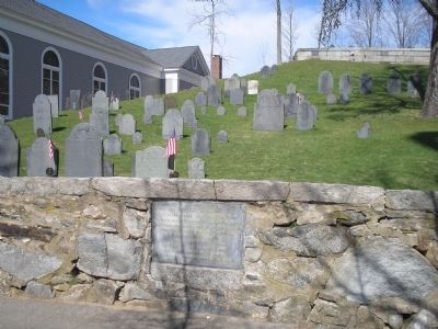
Settled before 1673, a town in 1680, divided by the New Hampshire – Massachusetts boundary, the northern part becoming Nashua, New Hampshire in 1741. — — Map (db m43415) HM
Born in Hesse-Darmstadt September 4, 1796 A fearless advocate of Liberty and Justice. Exiled for conscience sake, he sought in America the freedom denied him in the Old World. Distinguished for rich and varied learning, for uncompromising devotion . . . — — Map (db m19194) HM
While Thomas Eames sought help from Boston February 1, 1676, the Indians attacked his house which stood nearby. His wife and five children were slain and four children captured. — — Map (db m195313) HM
(marker north side)
John Tinker an original petitioner and one of the first selectmen of Groton built, prior to 1659, an Indian trading post about 500 yds easterly of this marker. The first settlement was made nearby soon afterwards. . . . — — Map (db m136600) HM
Engineer James B. Francis knew that the city of Lowell needed protection from floods. He studied the Merrimack River and understood the dangers of flooding introduced by the canals flowing through the city. The Guard Locks controlled the normal . . . — — Map (db m48418) HM
Lowell was founded upon the confluence of the Merrimack and Concord Rivers to become a nineteenth-century textile manufacturing empire. The city later faced urban decline when industry left the region. On January 3, 1989, George L. Duncan, a . . . — — Map (db m117778) HM
On Wickasee Island (now Tyngs Island) in the Merrimac dwelt Wannalancet, last sachem of the Pennacook Confederacy, and like his father Passaconway, a faithful friend to the English. — — Map (db m48022) HM
Site of first meeting house completed in 1662, Rev. William Brimsmead Minister. It was built within the limits of the Indian planting field which was part of the Ockoocangansett Plantation, and was a source of hostile feelings toward the settlers. . . . — — Map (db m66595) HM
The first tavern was erected on this site by Lieutenant Abraham Williams in 1665. Destroyed by Indians in 1676, it was promptly rebuilt and managed by the Williams Family until 1829. Here the early Circuit Courts convened, stage coaches changed . . . — — Map (db m48023) HM
This elegantly detailed Victorian Gothic building is the seventh meeting house of Natick's first Church established in 1651 by John Eliot. The church moved to this location at the geographic center of town in 1799 from the original settlement in . . . — — Map (db m218969) HM
One-eighth of a mile to "the
simple home of an ordinary man,
not wealthy, not particularly
distinguished, but a type of the
God-fearing yeomanry .... as
Ephraim Parker left it, it
remains today an unchanged
relic in the midst of a . . . — — Map (db m48840) HM
Settled 1638 by a company of Puritans who arrived in the ship "Confidence" and were attracted by the meadows on the Musketaquid River. Named after Sudbury in Suffolk. — — Map (db m48028) HM
HERE LANDED ROGER CLAP AND THE DORCHESTER MEN JUNE 1630
We went up the Charles River, until the river grew narrow and shallow, and there we landed our goods with much labor and toil, the bank being steep; and night coming on, we were informed . . . — — Map (db m43363) HM
Settled by Puritans in 1630 under the leadership of Sir Richard Saltonstall and the Rev. George Phillips who stood firmly for religious toleration and the right of the people to a representative government. — — Map (db m48029) HM
Settled by Puritans in 1630 under the leadership of Sir Richard Saltonstall and the Rev. George Phillips who stood firmly for religious toleration and the right of the people to a representative government. — — Map (db m48030) HM
Site of first bridge crossing the Aberjona River over against the Edward Converse House, also site of the King's Ford located at lower side of bridge from 1638 to 1845. — — Map (db m82666) HM
In 1638 this tract of about one hundred and twenty acres was granted by the town of Charlestown to its Teaching Elder John Harvard. He died the same year, aged thirty-one, leaving half his property to the College which was then named after him. — — Map (db m48833) HM
Original Town Common circa - 1898 The Bellingham Police Department now stands on the original green of the Town Common. The small building in the center was the town's lock-up facility which was erected in 1875. The two-room Massey School House . . . — — Map (db m195740) HM
Town Center circa 1898 This is a panoramic view of the Town Center as it appeared in 1898. On the left sits the Bellingham Town Hall which was constructed in 1802. This early photograph depicts this historical building as it appeared almost one . . . — — Map (db m195741) HM
Settled by members of the Atherton, Boyden, Hodges, Morse, Pratt, Robbins and other families, This section was known as Robbins Corner for many years. The identity changed with the arrival of the railroad and the establishment of East Foxboro Depot . . . — — Map (db m55869) HM
The homes on Baker Street represent people and diverse architecture from two significant periods of Foxborough history, the 19th century straw hat era and the 20th century transition to industrial manufacturing. — — Map (db m55872) HM
First Settler The first dwelling in what would become Foxborough was erected in 1669. It was located west of nearby Wading River on a farm laid out for Captain William Hudson who
was a Boston tavern keeper. Hudson never lived here, but leased . . . — — Map (db m55866) HM
Populated by members of the Morse family since the early 1700's, this section of Foxborough was known as Morseville. By 1737, Jedediah Morse had dammed the Neponset River forming Crack Rock Pond and built both a saw mill and a bloomery forge near . . . — — Map (db m55879) HM
Originally settled as Paineburgh, taking its name from the many members of the Paine family who settled here, this section of Foxborough had a strong sense of community with its own elementary school, chapel, railroad station and Post Office. . . . — — Map (db m55870) HM
To help support its public school,Dorchester set aside a 650 acre farm in this vicinity which it leased in 1710 to Robert Calef for a total of 308 years. Solomon Hews was operating a tavern here in 1728 when governor William Burnet and the . . . — — Map (db m55885) HM
Set apart after 1640 • • • • • Here lie buried The early settlers of the town the first minister the first teacher Rev. John Hancock (1702 – 1744) for whom this place is named Father of the patriot Henry Adams (1583 – 1646) and . . . — — Map (db m31249) HM
Here lyeth the body of Henry Adams founder of the Braintree branch of the Adams family in America buried in this cemetery Oct. 8, 1646 — — Map (db m31253) HM
Incorporated 1793 — Bicentennial 1974
Part of Mt. Wollaston Settlement 1625
Indian Deed Grant
by Wampatuck Sagamore,
Sachem Chief Chicataubut
in reign of Charles II 1665 — — Map (db m117904) HM
Welcome to the Alden House Historic Site Part of original land grant given to Mayflower Pilgrims John and Priscilla Mullins Alden in 1627 and home to generations of Aldens. The property is now a National Historic Landmark and owned by the Alden . . . — — Map (db m177585) HM
Capt. Myles Standish. (c. 1584 - October 3, 1656) was one of the passengers aboard the Mayflower, arriving in Plymouth Colony in the late-fall of 1620. Little is known of his early life and career. He was most likely raised in . . . — — Map (db m147415) HM
Site of Nook Gate Here a palisade was erected across the Nook in 1634 This palisade was a high fence to prevent cattle from straying and probably to keep the Indians out Town of Duxbury 1940 — — Map (db m147749) HM
Welcome to the Old Burying Ground, c. 1632-1787 The Old Burying Ground (also known as the Myles Standish Burying Ground) is the oldest maintained cemetery in the United States. The first burials occurred here as early as 1632, shortly after . . . — — Map (db m147784) HM
The Old Burying Ground (also known as the Myles Standish Burying Ground) is the oldest maintained cemetery in the United States. The first burials occurred here as early as 1632, shortly after the area began to be permanently settled by Europeans. . . . — — Map (db m160432) HM
In grateful memory of Reverend Peter Hobart and that company of English men and women who founded the town of Hingham, landing near this spot in September, 1635 — — Map (db m2851) HM
Samuel Lincoln, ancestor of President Abraham Lincoln, and one of the eight early settlers of Hingham bearing that name, purchased this land in 1649. Seven generations of Lincoln descendants lived here. — — Map (db m42633) HM
To Honor and Perpetuate the Memory of
John Eddy and Samuel Eddy
Arrived at Plymouth on the “Handmaid” Oct. 29, 1630
Sons of Rev. William Eddye, B.A., M, A. Cambridge, England
Vicar of St. Dunstan church, Cranbrook, Kent . . . — — Map (db m75829) HM
Plymouth, “America’s Hometown” is the site of the first permanent settlement of English Colonists in New England. Climb aboard Mayflower II, a recreation of the ship that sailed the Pilgrims to the new world . . . and learn . . . — — Map (db m107545) HM
The Pilgrams landed in Plymouth, America's Hometown, in December 1620. Covering 102 square miles, it is the largest town in the Commonwealth of Massachusetts. Plymouth's shoreline stretches 37 miles along Cape Cod Bay and with its boundaries lay 365 . . . — — Map (db m108370) HM
Brewster Gardens Brewster Gardens was created in 1921-1923 through the imagination, dedication and persistence of several Plymount women as part of the Plymouth's Tercentenary celebration of the landing of the pilgrims. It encompasses the . . . — — Map (db m151301) HM
This lot bounded by Middle or King St. and LeBaron Alley was once owned by Dr. Samuel Fuller of the Mayflower and was given by his wife and son to the First Church for the use of the minister. — — Map (db m107437) HM
They believed in religious freedom in honor of Edward Doty Passenger on the Mayflower Erected by Descendants of Eliza Doty Gravath A pioneer to Utah in 1850 — — Map (db m107526) HM
In memoriam Elder William Brewster Patriarch of the Pilgrims and their ruling elder 1609-1644 Outstanding leader of Pilgrim movement, the founding of Plimouth Plantation and the establishment of civil and religious liberty in the New World. B. at . . . — — Map (db m107522) HM
This monument marks the first burying ground in Plymouth of the passengers of the MayflowerHere, under cover of darkness, the fast dwindling company laid their dead, leveling the earth above them lest the Indians should learn how many were the . . . — — Map (db m107416) HM
This tablet is erected by the Commonwealth of Massachusetts to mark the site of the First House Built by the Pilgrims. In that house on the 27th of February 1621 new style the Right of Popular Suffrage was exercised and Miles Standish was chosen . . . — — Map (db m107431) HM
This Original House was built in 1745 by Isaac Doten who was the Constable for the town of Plymouth, which at that time was a British Colony under the reign of George II of England. — — Map (db m107434) HM
Site of the house where John Alden lived while in Plymouth. This stone erected by his descendants The Alden Kindred of America 1930 — — Map (db m107378) HM
Leyden Street, originally known to the first settlers as First Street, Great Street or Broad Street, is where the Pilgrims began building their houses in the winter of 1620-21, and it has been the heart of the town ever since. Extending from the . . . — — Map (db m75830) HM
H I William Bradford of Austerfield Yorkshire England. Was the son of William and Alice Bradford. He was Governor of Plymouth Colony from 1621 to 1633 1635 1637 1639 to 1643 1645 to 1657 < Rear of obelisk : > Under this stone rest . . . — — Map (db m107510) HM
Here lies buried ye body of Mr. Thomas Clarke Aged 98. Departed this life March 24, 1697. Thomas Clarke was Mate of the Mayflower according to tradition in the Plymouth and connecting Colonies. History gives his arrival in Plymouth from England in . . . — — Map (db m107462) HM
To those intrepid English women whose courage fortitude and devotion brought a new nation into being, this statue of the Pilgrim Maiden is dedicated. Presented to the Town of Plymouth by the National Society New England Women September IV . . . — — Map (db m107423) HM
Pilgrim Memorial State Park-Plymouth Rock is a symbol for the potential the Pilgrims saw in America upon their arrival here in December of 1620. Seen as solid, steadfast and everlasting, the large Dedham granite boulder is a suitable icon for the . . . — — Map (db m62450) HM
You are standing at the corner of Leyden Street and Water Street. Leyden Street is the first street laid out in Plymouth and the location of the first Pilgrim homes. From this location one can see Cole’s Hill, the Waterfront and Leyden Street . . . — — Map (db m75819) HM
Fellow-exile with the Pilgrims in Holland, afterwards their chief agent in England. Arrived here IX November, MDCXXI, with Thomas Cushman his son; Preached IX December, his memorable sermon on “The danger of self-love and the sweetness of true . . . — — Map (db m107459) HM
Site of one of the houses built in 1621. Seven dwelling houses were built the first year in addition to the one occupied by the Governor. This lot was assigned to Peter Brown. — — Map (db m107440) HM
The Church of Scrooby Leyden and the Mayflower gathered on this hillside in 1620 has ever since preserved unbroken records and maintained a continuous ministry. Its first covenant being still the basis of its fellowship. In reverent memory of its . . . — — Map (db m107446) HM
The National Monument to the Forefathers was added to the National Register of Historic Places by the National Park Service, the Department of the Interior in September 1974. The monument, designed by Hammet Billings of Boston, was erected by the . . . — — Map (db m56067) HM
Pilgrim Memorial State Park is designed around Plymouth Rock, a large glacial boulder deposited in the harbor and smoothed by centuries of tidal wash. The rock is not only a landmark, but also a symbol of the courage and faith of the men and women . . . — — Map (db m107542) HM
William Bradford Governor and Historian of the Plymouth Colony Born in Austerfield, England – 1590 Died in Plymouth, New England – 1657 < Side of Monument : > “So they lefte ye goodly & pleasante citie, which had been . . . — — Map (db m75823) HM
Home of the Scituate Historical Society on land granted to Richard Garrett prior to 1646. Zephanian Cudworth built the present house in 1797 around the original chimney. — — Map (db m47900) HM
Front:
“Erected on this Lott
Aug. Ye 2d & 3d dayes, 1636.
Exercised in Novemb. 10 & 11, 1636.”
Top:
To the Memory of
The First
Ministers of Scituate
Giles Saxton — Nathaniel Pitcher
John . . . — — Map (db m30616) HM
A unique historical site in that its construction spans nearly three centuries. Five generations of the Mann family lived in this house. They were direct descendants of Richard Mann who settled in Scituate in 1636. — — Map (db m43638) HM
Burial place of many of the town’s original settlers who came from Kent County, England, in 1628. This is also the site of the first church in Scituate, built in 1634. — — Map (db m30615) HM
From which the town derived its name. The Indian word first written Satuit or Seteat, meaning cold brook, was changed in 1640 to Scituate. — — Map (db m42628) HM
The first plantations at "Satuit" were laid out by the Men of Kent before 1628 on this cliff, which was then much more extensive. — — Map (db m48038) HM
The land of this park was bought in 1649 from the Massasoit Indians by Miles Standish and others as part of the Bridgewater Purchase and allotted to John Ames an original shareholder and settler
And here before the Revolutionary War, the . . . — — Map (db m209431) HM
In Honored Memory of
Deacon Samuel Edson
Bapt. Sept. 5, 1613
Fillongley, Warwickshire, England
An Original Proprieter of Bridgewater
he, with 56 Share Holders including
Miles Standish and "Goodman Alden"
bought the land Mar. 23, 1649 . . . — — Map (db m209435) HM
Near this spot was the Home of
John Cary
Born in Somersetshire England
He became in 1651 an Original Proprietor
And Honored Settler on this River.
The Clerk of the Plantation.
When the Town of Bridgewater was
Incorporated in 1656 he . . . — — Map (db m209439) HM
The Walk to the Sea encompasses four centuries
of Boston history. Beginning at the State House on
Beacon Hill, overlooking Boston's ancient Common,
the Walk passes among historic landmarks and
skyscrapers. The Walk crosses ground that, . . . — — Map (db m176177) HM
For wee must consider that wee shall be as a citty vppon a hill the eies of all people are vppon vs soe that if wee shall deale falseley with our God in this worke we haue vundertaken… wee shall be made a story and a by-word through the world - . . . — — Map (db m215096) HM
Born Horncastle Parish Lincolnshire England 5 March 1596
Graduate of Emanuel College England 1621
First settler of Shawmut 1625
Near here stood his dwelling
He removed to Rhode Island 1635
Where he died May 26 - 1675
"The place of his . . . — — Map (db m215097) HM
The Common an Historic Overview In 1634, only four years after John Winthrop and the Puritans of the Massachusetts Bay Colony settled the Shawmut Peninsula and created the town of Boston, these colonists bought a 48-acre tract of land on the . . . — — Map (db m176868) HM
The Historic Beacon Hill District has been designated a Registered National Historic Landmark
under the provisions of the Historic Sites Act of August 21, 1935 This site possesses exceptional value in commemorating or illustrating
the . . . — — Map (db m176189) HM
Native American Settlement
Native American occupation of the Charlestown peninsula predates European settlements by approximately 10,000 years. Archaeological evidence, such as tools made of stone, bone, wood, and shells, suggests the early . . . — — Map (db m60237) HM
Near here, August 23rd 1630
Governor John Winthrop
and members of the Massachusetts Bay Company
organized the Court of Assistants
forerunner of the
Supreme Judicial Court of Massachusetts — — Map (db m97405) HM
In 1989 Oliver Place was renamed Ping On Alley, "Alley of Peace and Security,” in honor
of Boston's first Chinese immigrants. They
pitched their tents here beginning in 1875, and
since that time this site has been central to the
lives of a . . . — — Map (db m176300) HM
1600
Native Americans
Native Americans inhabited this area for at least 10,000 years before the arrival of Europeans. Although contact with European explorers and fishermen in the early 1600s resulted in heavy loss of life from European . . . — — Map (db m215646) HM
Until a few decades before the American Revolution, Boston was the largest port in the British colonies. It thrived on maritime trade, shipbuilding, and the work of hundreds of craftspeople. While the tombs of the rich merchants and politicians ring . . . — — Map (db m18795) HM