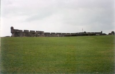
This Spanish fort, begun in 1672, stood
firm against English attacks and helped
Spain to hold Florida for many years.
During the American Revolution it was a
British stronghold. Later it became a
U.S. Military Prison. — — Map (db m127652) HM
Coquina in these Walls (English)
Special to the architecture of Government House and St. Augustine's defenses, churches, and residences is coquina, a rare native shell stone formed over a long period of geological time and quarried since . . . — — Map (db m127486) HM
The event that brought the civil rights movement in St. Augustine to international attention was the arrest of Mary Parkman Peabody (1891-1981), the 72-year old mother of the Governor of Massachusetts, for trying to be served in a racially . . . — — Map (db m7610) HM
Markland, the Anderson family home, has been a local landmark since 1843. Dr. Andrew Anderson, a prominent civic leader, laid the foundations of the coquina shellstone house in 1839 just before his death in a yellow fever epidemic. The original . . . — — Map (db m77212) HM
Home of Rev. Goldie M. Eubanks, Senior, his wife Hattie and nine children. Humbled by Family and Fatherhood, Leadership and Christian Fellowship, and driven by a cry from within his inner soul to make this world a better place, this self-styled . . . — — Map (db m7080) HM
Mary McLeod Bethune Home
has been designated a
National
Historic Landmark
This site possesses national significance in commemorating the history of the United States of America
1975
National Park Service
United . . . — — Map (db m192160) HM
Ponce de Leon Inlet Lighthouse Has Been Designated A National Historic Landmark This site possesses national significance in commemorating the history of the United States of America 1998 National Park Service United States Department of . . . — — Map (db m34434) HM
For over 100 years Etowah Indian Mounds were the Tumlin Mounds. In 1832 Col. Lewis Tumlin came to Cass County (Bartow) and drew the land lot that contained the mounds. Col. Tumlin served as county sheriff from 1834 to 1840. As young soldiers, Gen. . . . — — Map (db m13471) HM
The history of Roman Catholicism in Macon dates to a visit in 1829 by Bishop John England of the Diocese of Charleston and the subsequent migration of Irish Catholic families in the 1830s. In 1841 Macon's Catholics received their first pastor, . . . — — Map (db m22189) HM
This church, the oldest congregation in lower Bryan County, was certified by the Presbytery of Georgia in 1830. Its founders included rice planters on Bryan Neck, among them Thomas Savage Clay, Richard James Arnold and George Washington McAllister. . . . — — Map (db m18648) HM
Granted 1739 to William Stephens
Secretary
Colony of Georgia
1737 - 1740
President
1743 - 1751
Here in 1779 under
Count d'Estaing the
French landed to join
the Americans under
General Lincoln in
the Siege Of Savannah . . . — — Map (db m9149) HM
In 1757, during the administration of royal Governor Henry Ellis, a line of earthwork defenses, including a palisade, was erected around Savannah. Immediately west of this marker was located Bethesda Gate, one of the six entrances into the town. . . . — — Map (db m5356) HM
Entered on the National Register
of Historic Places
June 7, 1974
Federal Building
U.S. Courthouse
Wright Square Postal Station
Savannah, Georgia
Jeremiah O'Rourke
Architect 1899
This Property Significantly Contributes . . . — — Map (db m19824) HM
The house adjacent to this building was the home of Juliette Gordon Low at the time she founded Girl Scouting in the United States, March 12, 1912. Formerly the carriage-house and stable of the Low mansion, this building became that year the first . . . — — Map (db m5583) HM
On this site in 1852 stood the Excelsior Bottle Works operated by John Ryan for the manufacture of soda water and other carbonated beverages. Ryan's soda, in colorful bottles embossed with his name and location, was known throughout Georgia. His . . . — — Map (db m14495) HM
Johnson Square is named for Governor Robert Johnson of South Carolina who befriended the colonists when Georgia was first settled. It was laid out by Oglethorpe and by Colonel William Bull in 1733, and was the first of Savannah's squares. In early . . . — — Map (db m5494) HM
Madison Square was laid out in 1839 and is named for the fourth President of the United States. Around the Square stand notable examples of Greek Revival, Gothic, and Romanesque architecture characteristic of nineteenth century Savannah.
To the . . . — — Map (db m6377) HM
The Savannah Cotton Exchange building was completed in 1887 during the era when Savannah ranked first as a cotton seaport on the Atlantic and second in the world. In its heyday as a cotton port over two million bales a year moved through Savannah. . . . — — Map (db m4904) HM
A fine example of Greek Revival style, this building (completed in 1840 from the plans of Charles B. Cluskey, a well-known Georgia architect) shows the distinguished trend of Savannah architecture during the first half of the 19th century. The . . . — — Map (db m5628) HM
Owens-Thomas House has been designated a National Historic Landmark. This site possesses national significance in commemorating the history of the United States of America. — — Map (db m19632) HM
This theatre is the oldest in active use
in the United States.
Built by the eminent architect Jay
Opened Dec. 4, 1818 with the Comedy
"Soldier's Daughter"
and a Farce
"Raising The Wind"
Within these walls have played
the greatest . . . — — Map (db m15135) HM
1834 1919
This tablet commemorates
The "John Randolph"
the first iron vessel seen in
American waters
Riveted together and launched here in 1834,
the plates having been made by John Laird
of Birkenhead, England, and . . . — — Map (db m81866) HM
1819 1919
This tablet
commemorates the centenary of
The "Savannah"
The first steamship to cross the ocean
The idea of this enterprise originiated with
William Scarborough
and his associates
citizens of Savannah
and . . . — — Map (db m8301) HM
The United States Customhouse stands on historic ground. In a house on this site, James Edward Oglethorpe, founder of the colony of Georgia, lived for a time, and in 1736 John Wesley preached his first sermon at Savannah in a building which stood on . . . — — Map (db m5441) HM
This Square, which was laid out in 1733, was originally named for John Percival, Earl of Egmont, who played a large part in founding the Colony of Georgia. Its name was changed around 1763 to Wright Square in honor of James Wright, Royal Governor of . . . — — Map (db m6378) HM
In the 1840s, William Brown Hodgson (1801-1871) conceived the idea of setting aside ten acres of wooded land at this site for development of Savannah's first recreational park. It was named for former Georgia Governor John Forsyth (1780-1841). . . . — — Map (db m6092) HM
The Cockspur Island Lighthouse, located in front of you was built in 1856. Six years later it was a silent witness to the Battle of Fort Pulaski. On April 10-11, 1862, the lighthouse was located midway between Union forces here on Tybee Island and . . . — — Map (db m19678) HM
After the repeal of the anti-slavery provision in the Charter of the Colony of Georgia on 1749, an act permitting the importation of slaves ordered the erection of a Lazaretto (Quarantine Station) on Tybee Island. Not until 1767 were 104 acres . . . — — Map (db m12953) HM
Launched in 1994. the international and inter-regional project The Routes of Enslaved Peoples: Resistance, Liberty, Heritage addresses the history of the slave trade and slavery through the prism of intercultural dialogue, a culture of peace and . . . — — Map (db m210668) HM
The Kennesaw Chapter United Daughters of the Confederacy was organized July 29, 1898, in the parlors of the Kennesaw House on the second floor corner nearest the railroad station. Mrs. R. L. Nesbitt was elected the first president. There were forty . . . — — Map (db m1665) HM
1889- Sunday School and cottage prayer meetings begun
1890- Church organized and admitted to Annual Conference; George Strickland elected steward; Service held in schoolhouse
1894- Services held in Presbyterian Church
1907- Baptist . . . — — Map (db m18520) HM
The highway leading south is a remnant of
the Old Sunbury Road, one of the leading
vehicular thoroughfares of post-Revolutionary
Georgia. It was laid out in the early 1790's
from Greensboro via Sparta and Swainsboro to
the Town of Sunbury, . . . — — Map (db m18621) HM
has been designated a
National Historic Landmark This site possesses national significance in commemorating the history of the United States of America May 5th 1977 National Park Service United States Department of the Interior
[bottom . . . — — Map (db m6675) HM
At the heart of any luxury resort or vacation retreat is sumptuous lodging. When the Jekyll Island Club incorporated in 1885, they knew that the success of the Club depended on a splendid but simple elegant Clubhouse. The Dubignon farmhouse . . . — — Map (db m17262) HM
There is very little photo documentation of
exactly what the Boathouse looked like during
the Club era. Club members rarely would have
been found in this area, It was typically used
by year-round employees.
The only visible evidence of . . . — — Map (db m115065) HM
Born in England Came to Georgia in 1736 Died at Savannah in 1748
These are the remains of Horton's tabby house. Major Horton of Oglethorpe's Regiment, the first English resident of Jekyll Island, erected on the north end of Jekyll a . . . — — Map (db m17577) HM
In 1736, on this historic site, Fort Frederica was constructed by the early settlers of the Colony of Georgia under General James Edward Oglethorpe. It was the strongest fortification built by Great Britain on American soil and its purpose was to . . . — — Map (db m18909) HM
This remnant is all
that time has spared of the
citadel of the town of Frederica
built by
General Oglethorpe
A.D. 1736
As an outpost against
The Spanish in Florida — — Map (db m18919) HM
" This Frederica is a very strange place; it
was once a town - the town, the metropolis of
the island."
Francis Anne Kemble
Visitor to Frederica
1839 Here, in unknown graves more than two centuries old,
lie many of the early . . . — — Map (db m18907) HM
"There are barracks in the town on
the north side, ninety feet square, built of tappy,
covered by cypress shingles; and a handsome
tower over the gateway...."
London Magazine
October 23, 1747 At the time of the Spanish attack in . . . — — Map (db m18917) HM
In 1804, Scottish-born plantation owner
John Couper sold four acres of land for $1 to the
new United States government to build the first
St. Simons Light Station. James Gould was hired
to design and build the lighthouse . . . — — Map (db m13463) HM
Surely the most important aspect of
the lighthouse to the mariner is the light
that emanates from the tower. The tall, white
beacon also serves as a day-mark. The light,
a 1,000 watt electric bulb, is reflected by a
fixed 3rd Order . . . — — Map (db m13464) HM
The historic Blair line between the State of Georgia and the Cherokee Nation crossed this highway at this point. This line was surveyed by James Blair in the early 1800’s. It ran from the forks of the Soque and Chattahoochee rivers in a direct . . . — — Map (db m43670) HM
The handsome gazebo was given in loving memory of Mr. and Mrs. J. L. Hand and placed in the Gardens in January, 1972. Constructed of longleaf pine, it was originally the belvedere atop the now demolished J. L. Hand home in Pelham, Georgia, the . . . — — Map (db m70847) HM
The city of Millen began about 1835 at a site 200 yds. N.of this marker as the road side inn of Robert Hendricks Gray. In Nov., 1851 the Wayneborough and Augusta Rail Road was extended to meet the line laid though here in 1839 by the Central Rail . . . — — Map (db m13151) HM
This fountain
was originally in the lobby
of the Estelle Hotel.
The hotel was constructed in 1912
and was located on
Gray Street in Millen, Georgia.
Through the generosity
of several local citizens, the
Jenkins County Development . . . — — Map (db m13340) HM
Organized in 1754 by the descendants
of an English Colony which came first
to Massachusetts 1630
to Connecticut 1635
to South Carolina 1695
and to Georgia 1752
Built on the same spot as the church
which was burned by the British in . . . — — Map (db m8999) HM
On the banks of Carnochan Creek, a short distance East of here, are the ruins of a famous Sugar Mill and Rum Distillery operated early in the 19th century.
These buildings, constructed of tabby by William Carnochan on his huge sugar plantation . . . — — Map (db m11382) HM
Near this point the Darien & Western Railroad
reached its terminus in 1895 after six years
of construction. Trains arrived daily at
Columbus Square then turned around for a
return trip to Tattnall County. The D&W
later became the Georgia Coast . . . — — Map (db m11172) HM
This ancient stone fortification,
885 feet in length, and the land on the crest
of this mountain, 2832 feet above sea level,
was given to the State of Georgia for the
establishment of Fort Mountain State Park
by
Ivan Allen
public spirited . . . — — Map (db m11572) HM
From the 1840's, this building stood among others of its type at this historic downtown intersection. Known traditionally as "Kinfolks' Corner," the area was the meeting place for generations of citizens from Columbus and neighboring Alabama . . . — — Map (db m101317) HM
Here, from 1862 to 1866, Joel Chandler Harris, author of "Uncle Remus", lived and worked as a printer's apprentice on what was probably the only newspaper ever printed on a Southern plantation, "The Countryman," a weekly newspaper edited and . . . — — Map (db m25355) HM
Liberty Hall
Has been designated a
National historic Landmark
This site possesses National significance in commemorating the history of the United States of America
1983
National Park Service
United States Department of the Interior — — Map (db m46025) HM
The name is derived from the Cherokee word ltse’yi (New Green Place) or (Place of Fresh Green, from ltse’hi (green or unripe vegetation), and yi, the locative. It occurs in several places in the old Cherokee country, variously spelled Echia, Echoee, . . . — — Map (db m32706) HM
This trail cuts across Kaloko-Honokohau National Historical Park, passing sites that represent many of the values for which this park was created, such as a malama ka aina, caring for the land. This was a place where Hawaiian families lived, values . . . — — Map (db m72001) HM
Kaloko-Honokohau National Historical Park celebrates the indigenous people of Hawaii. It penetrates deep into Hawaiian antiquity by preserving evidence of a thousand years of society. It links the touched with the heartfelt, transcending the . . . — — Map (db m71999) HM
Honokohau Settlement has been designated a Registered National Historic Landmark under the provisions of the Historic Sites Act of August 21, 1935. This site possesses exceptional value in commemorating and illustrating the history of the United . . . — — Map (db m4248) HM
This projection of land, more properly known by an older name, Kumukea Point, is a significant landmark of coastal Kekaha. The surface 'a'ā lava that covers this area is the result of the historic Ka'ūpūlehu Flow of 1801, which was . . . — — Map (db m110507) HM
South Point Complex has been designated a Registered National Historic Landmark under the provisions of the Historical Sites act of August 21st 1935. This site possesses exceptional value in commemorating and illustrating the history of United . . . — — Map (db m2314) HM
The row of hewn stone along the inner side of the road is a remnant of one wall of a water-course which is said to have been made by the MENEHUNES (Hawaiian dwarves or Brownies)
The stones were brought from Mokihana
There is an old . . . — — Map (db m27646) HM
Commonly called ʻĪao Needle, the traditional Hawaiian name for this 2,250 foot high peak is Kūka‘emoku. This peak is known as the phallic stone of Kanaloa, Hawaiian god of the ocean.
During periods of warfare, the peak was . . . — — Map (db m31540) HM
This reproduction of the Liberty Bell was presented to the people of Idaho by direction of The Honorable John W. Snyder Secretary of the Treasury
As the inspirational symbol of the United States Savings Bonds Independence . . . — — Map (db m128542) HM
Surrounded by high Rocky and very ragged looking mountains -- this valley we take the liberty to call Pleasant Valley, as it is a very good and pleasant for camping. -- Leander V. Loomis, circa 1850, describing the Circle Creek Basin. . . . — — Map (db m123961) HM
Up toward Camas Prairie, a road goes by Castle Rock and other eroded granite outcrops that were landmarks on Goodale's Cutoff, an Oregon Trail route that came this way.
Emigrants generally had not seen large granite rock formations of this . . . — — Map (db m110143) HM
On June 1, 1871, Frederick Post made a deal with Andrew Seltice -- a prominent Coeur d'Alene Indian leader -- to obtain more than 200 acres of Spokane River land to start a mill here. They recorded this cession of land on a prominent rock . . . — — Map (db m122126) HM
Captain Clark, after viewing the Continental Divide on August 22, 1805, remarked, “… we set out early passed a small creek on the right at 1 mile and the points of four mountains verry steep, high, and rockey. The assent of three was so steep . . . — — Map (db m109666) HM
Sixty million years ago, you wouldn't have recognized this place. There were no high mountains, no deep canyons. Streams meandered through a landscape of broad valleys and low hills that may have resembled Kentucky's Cumberland Valley.
The rocks, . . . — — Map (db m109669) HM
(There are five historical panels in this kiosk:)
Idaho's Emigrant Trails
Westward-bound emigrants entered Idaho after crossing Thomas Fork Valley. They soon encountered the climb and descent of Big Hill, witnessed . . . — — Map (db m124037) HM
Made by Trent Groothuis with help from Landon Hoehn & Brandi Millikan Year made: Spring/Summer 2020 Application submitted to Guinness World Records in June of 2020. Waiting to hear back in late Summer of 2020 to see if it meets the criteria for: . . . — — Map (db m229789) HM
This building is a significant early 20th-century industrial building built for one of Chicago's best-known manufacturers. Founded and headquartered in the city for many years, the Florsheim Shoe Company was one of the nation's leading shoe . . . — — Map (db m94316) HM
This Illinois - Indiana state boundary marker is one of the oldest landmarks in the Chicagoland area. It was constructed in 1838 under the direction of the United States Surveyor General to commemorate the establishment of the common boundary . . . — — Map (db m237902) HM
Designed by the architect of the Old Chicago Water Tower and predating it by five years, the Rosehill Cemetery Entrance is a rare Midwestern example of castellated Gothic architecture. Many prominent Chicagoans are buried here in plots marked by . . . — — Map (db m94331) HM
Featuring streetscapes of handsome mansions, apartment buildings, and institutional and commercial buildings from the 1880s through the 1930s, the District is one of the best-preserved portions of Chicago's extensive park boulevards system. — — Map (db m234590) HM
Featuring streetscapes of handsome mansions, apartment buildings, and institutional and commercial buildings from the 1880s through the 1930s, the District is one of the best-preserved portions of Chicago's extensive park boulevards system. — — Map (db m234591) HM
Featuring streetscapes of handsome mansions, apartment buildings, and institutional and commercial buildings from the 1880s through the 1930s, the District is one of the best-preserved portions of Chicago's extensive park boulevards system. — — Map (db m234592) HM
Featuring streetscapes of handsome mansions, apartment buildings, and institutional and commercial buildings from the 1880s through the 1930s, the District is one of the best-preserved portions of Chicago's extensive park boulevards system. — — Map (db m234593) HM
Featuring streetscapes of handsome mansions, apartment buildings, and institutional and commercial buildings from the 1880s through the 1930s, the District is one of the best-preserved portions of Chicago's extensive park boulevards system. — — Map (db m234594) HM
Built as speculative housing by John Gauler, this pair of wood-and-stucco residences is a rare example of a "twin" Prairie School design. Their architect is internationally recognized for his distinctive designs and for his early contributions to . . . — — Map (db m68556) HM
Known as the widow Clarke's house, this is Chicago's oldest building and its only surviving example of the Greek Revival style fashionable in the early 1800s. — — Map (db m69587) HM
A rare survivor of the stately mansions built on the Near South Side prior to the Great Chicago Fire of 1871, this also ranks as one of the city's best examples of Second Empire architecture. Built by banker Calvin Wheeler, it was remodeled in the . . . — — Map (db m69591) HM
Designed as a "model home," this Queen Anne-style house was built for Irving Park land developer Charles N. Loucks. It is a fine example of "pattern book architecture," building designs sold through the mail--a popular method used to keep pace with . . . — — Map (db m66329) HM
Settled in the 1850s by German immigrants, this area was virtually destroyed by the Fire of 1871. Most of these wood cottages and brick and stone townhouses date to the last decades of the 19th century. After World War II, this area became the focus . . . — — Map (db m47626) HM
Built as the headquarters of one of the leading varnish manufacturers in the United States, this building is a rare Chicago example of Dutch Renaissance Revival-style architecture, marked by distinctive stepped gables. It was designed by Henry . . . — — Map (db m234669) HM
One of the last of Wright's small urban houses, the Bach House combines elements of the Prairie Style with a compact plan well suited for an interior lot. The inward orientation of the house ensures the privacy of its residents and reflects Wright's . . . — — Map (db m59980) HM
This rare surviving example of Victorian Gothic design is also one of the city's best late-19th century apartment buildings. Because early luxury apartments were viewed with skepticism, this building was designed to look like a series of four . . . — — Map (db m66612) HM
In this its centennial year the Chicago Water Tower has been designated the first American Water Landmark “because of its significance in the development of Chicago’s water resources and its symbolic identity with the spirit of . . . — — Map (db m47575) HM
Finely detailed with tapestry brick and carved stone ornament, this Arts & Crafts-influenced facade is an excellent example of the type of designs for which this architectural firm was noted. "Towertown," as the area surrounding the Chicago Water . . . — — Map (db m66729) HM
This water tower, completed in 1869, marks establishment of Chicago’s second water works. Although most other buildings of pumping system were burned it stands as a principal memorial of 1871’s great fire.
Erected by
Chicago’s Charter . . . — — Map (db m47576) HM
Tribune Tower
John Mead Howells and
Raymond Hood, architects
1925
This design was the result of an international competition for ‘the most beautiful office building in the world,” held in 1922 by the Chicago Tribune. The . . . — — Map (db m106357) HM
The extraordinary engineering talent of Dankmar Adler and the architectural genius of Louis Sullivan created this building to reflect the cultural maturity of Chicago. Combining hotel and office space with a splendid theater, the Auditorium was a . . . — — Map (db m34975) HM
An outstanding example of Modern French style of Beaux-Arts Classical architecture. As one of the city's earliest luxury hotels, it became the "Hotel of Presidents," serving as host to a dozen U.S. Presidents, including Woodrow Wilson, Franklin D. . . . — — Map (db m94409) HM
According to popular legend, the architects chose this building’s dark green and gold colors based on a gold-foiled champagne bottle seen at an office holiday party. Whether true of not, the building is one of the most-distinctive features on . . . — — Map (db m51698) HM
1646 entries matched your criteria. Entries 401 through 500 are listed above. ⊲ Previous 100 — Next 100 ⊳