Prominent local businessman William Pollman contracted to have the Baker Loan and Trust Building built in 1910, after a major fire destroyed another building on the site, along with two buildings to the south.
The building was designed by . . . — — Map (db m108043) HM
Basche-Sage Hardware Co. was one of Baker City’s largest firms for more than 100 years. The company began when Peter Basche purchased a Baker City tin shop in 1876. In 1888, Basche merged with the Sage and Grace hardware store. Stores were opened in . . . — — Map (db m108084) HM
The Bishop Building stands as a testament to the strength and durability of volcanic tuff, which was used to construct many of Baker City’s major buildings during the first decade of the 1900s. A fire gutted the building in 1940, but it remained . . . — — Map (db m108079) HM
The central two-story portion of their building was constructed in 1910. In the 1940s, single-story wings of reinforced concrete were added to both sides of the original structure.
In its early years, the building housed the Chas. I. Flynn and . . . — — Map (db m108102) HM
When Baker City reigned as the “Queen City of the Inland Empire,” the Geiser Grand Hotel was a jewel in her crown. Built in 1889, the hotel soon earned a reputation for offering the finest accommodations between Seattle and Salt Lake . . . — — Map (db m108065) HM
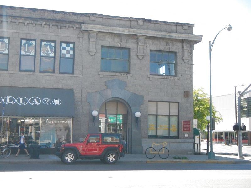
This building was one of Baker City’s first masonry structures when constructed about 1879. Solomon’s One Price Clothing House originally occupied the first floor of the north half of the building. By the 1990s, footware had been sold in the . . . — — Map (db m108211) HM
In October 1940 Gwilliam Brothers Bakery celebrated the business’s new building with a grand opening. Designed for high-volume bakery operations, the brick structure had a delivery truck garage in the rear and a large central oven set on a concrete . . . — — Map (db m108161) HM
Haskell was one of Baker City’s leading real estate developers of the late 1800s and early 1900s. He also engaged in many other pursuits.
He was born in 1850 in Ohio. At age 18, he went to Montana to become a miner. He later mined in Nevada, . . . — — Map (db m108064) HM
The lot which this building occupies was first the location of a wood frame structure housing the McCord Brothers blacksmith shop. In 1867, Dr. J.M. Boyd and John W. Wisdom leased the structure to open Baker City’s first drug store. Wisdom continued . . . — — Map (db m108041) HM
John Jett’s stonemason’s skills are manifest in the inscription carved at the roof level of his building - “J.H. Jett Marble Works, 1901.”
The Jett Building was the first in Baker City of volcanic tuff construction. Ten commercial or . . . — — Map (db m108206) HM
This site was the location of Baker City’s first brick hotel, the Cosmopolitan. The Rev. P. DeRoo, a Catholic priest who aquired (sic) extensive real estate interests, had the two-story building built in 1875. The hotel also served as the city’s . . . — — Map (db m108063) HM
Mike Hoff, a “tonsorial artist” (barber) in Baker City in the 1890s, built this building for his business. After a few years, however, Hoff went into partnership with Valentine Bildner to open a saloon in the building.
During the . . . — — Map (db m108060) HM
The Lynndale Building was constructed about 1890. The northernmost of the three first-floor bays was occupied by a saloon from the building's earliest days. The establishment first was named Henry the Fourth, then The Club. Later it became the . . . — — Map (db m108077) HM
The Mann Block, built in 1890, originally housed one of the many saloons located in this block during Baker City’s early, rowdy years. Like most of the establishments, the saloon operated on the first floor, with a bawdy house and gambling rooms . . . — — Map (db m108052) HM
This building was the location in the 1920s of the Lew Brothers Tire Co., which later moved to Bridge Street. After the tire company relocated, the building was purchased by Glenn Miller, owner of Miller’s Lunch in the adjacent building to the east. . . . — — Map (db m108097) HM
The Mint-Fox Building was constructed as two adjoining structures, the south half in 1888, the north in 1889. The buildings were erected by A.A. Houston, a local builder. Houston first rented the south building to two miners, Lorenzo Durkee and . . . — — Map (db m108061) HM
The Old Post Office building served as Baker City’s post office for 58 years, from completion of construction in 1910 until 1968, when the Post Office relocated to a new Federal Building a block to the south. The building also housed offices of the . . . — — Map (db m108042) HM
Baker City at the beginning of the 20th Century was the hub for a vast area of commerce, including mining, agriculture and forest products. Merchandise flowed into the city for distribution to dozens of smaller communities. Likewise, business . . . — — Map (db m108194) HM
William Shoemaker, a partner in a Baker City wholesale grocery and grain business, built this building in 1906. Before moving to Baker City, Shoemaker had been in business at Rock Creek, a small community in north Baker Valley. He built and operated . . . — — Map (db m108103) HM
In 1900, after a fire had destroyed a former wood frame hall, the Baker City Masonic Lodge erected a new brick temple.
The lodge hall occupied the second floor. The first floor originally was leased to the E.P. Voruz & Co. Home Furnishing Store . . . — — Map (db m108081) HM
Hand-cranked telephones first rang in Baker City in 1889. Not until 1898, however, did a company succeed in establishing 24-hour, central exchange service. When inaugurated, the system had 40 subscribers and one operator on duty.
The first . . . — — Map (db m108195) HM
This property, which consists of parts of two adjacent structures built in the 1880s, was the location of many Baker City businesses over the years. One of the first was Basche-Sage Hardware Co., which was to grow into one of the Northwest’s largest . . . — — Map (db m108039) HM
A fire that started in a billiard hall destroyed all the structures on this block in 1886. Several property owners chose to rebuild, and four adjoining brick buildings were constructed the following year. This building was constructed for Messrs. . . . — — Map (db m108050) HM
A committee of civic-minded Baker City residents began meeting in 1911 to organize a fund-raising campaign to build a Young Men’s Christian Association building. The committee soon had secured pledges of more than $30,000.
Plans for the . . . — — Map (db m108098) HM
The Corvallis City Hall was located on the southeast corner of Fourth and Madison Streets from 1892 to 1956. This grand brick and stone building with the imposing belltower housed the City Council Chambers, and in addition, provided much of the . . . — — Map (db m112916) HM
Mechanical Hall
This structure was built in 1899 to replace the original Mechanical Hall that burned to the ground on September 27, 1898. That fire threw the school year into chaos, since the building had housed the entire engineering program . . . — — Map (db m112864) HM
The L.G. Kline Building was built in 1889 for Lewis G. Kline after his successful career as a dry goods merchant in Corvallis.
Kline, a Polish immigrant, came to Corvallis with his wife, Adaline, a Russian immigrant, in 1864. The Klines and . . . — — Map (db m112915) HM
The Opera House was built on this site in 1870. It was a wooden building with a porch and covered entrance which faced on Fourth Street. The residents of Corvallis raised the money by subscription and donated their labor to build it. Inside there . . . — — Map (db m112917) HM
Philomath College was chartered November 1865, as the United Brethren School for Oregon, Washington, Idaho, Montana and California. The name combines two Greek words meaning love of learning. The building’s center structure was completed in . . . — — Map (db m122509) HM
dedicated September 28, 1937 by
Franklin D. Roosevelt
President of the United States
as a monument to the skill and faithful performance of workers on the rolls of the Works Progress Administration — — Map (db m112336) HM
On this site was an early firehall. Current structure was built as City Hall housing city offices, Police Dept., and the jail, all of which remained until the mid 40s. Oregon City Beauty School occupied main floor and basement for 22 years. Jail . . . — — Map (db m8747) HM
Built by Ed Johnson as a full service barber shop with 4 chairs and bathing facilities. Basement still has massive brick boiler for hot water originally fired by sawdust from local mill. Converted to restaurant in 1986. — — Map (db m8746) HM
Little is known about the first ten years after Horace and Jane Baker arrived in the 1846 Barlow Trail wagon train, and the construction of this cabin. Perhaps, like most pioneers they lived out of their wagon or tents the first winter. Most then . . . — — Map (db m114233) HM
Built in 1903, this building was important to area social life, serving as Wilsonville's first “community center.”
Meetings were held in a lodge hall that occupied the second floor. Area residents would also flock to the upstairs . . . — — Map (db m127203) HM
The Tauchman House overlooks the site of one of the Willamette River's first ferry operations, started in 1847 by Daniel Boone's grandson, Col. Alphonso Boone.
In the early days, the ferry boat transported passengers, wagons and livestock . . . — — Map (db m114278) HM
Built in 1905, The Cottage Hotel is one of the many buildings constructed during the time that the Oregon Electric Railway ran through Wilsonville. The hotel’s business was directly dependent on the railroad’s passenger service. A boardwalk ran from . . . — — Map (db m127206) HM
Built by Capt. Hiram Brown who came to Astoria area in 1848.
Original Portion of house built in Adairville (East Astoria), was barged downriver about 1865 to Tenth St. and rolled to present location without cracking wallpaper or breaking a . . . — — Map (db m114258) HM
This lighthouse, officially the Coquille River Lighthouse, stands today as a reminder of a past era when safe shipping depended on a lightkeeper and his light.
From within the stuccoed brick walls of the adjoining 47 foot tower was a fixed, . . . — — Map (db m113914) HM
Gold Beach Ranger Station constructed 1936–37 placed on the National Register of Historic Places April 8, 1986 The nine original buildings on this site were designed by W.I. Turner and constructed by Civilian Conservation Corps . . . — — Map (db m113206) HM
"Klondike Kate" (Kitty Rockwell) was also known as the "Queen of the Yukon" during the Klondike Gold Rush and came to Bend in 1914. She made a small fortune in the Yukon as the region's leading singer and dancer but fell in love with Alex Pantages, . . . — — Map (db m157837) HM
A.J. Tucker came to Bend in 1916 with $180.00 in his pocket. His first work in Bend was building boats and guiding hunting parties from the eastern United States.
Tucker soon set his sights on building, and went on to create several of Bend's . . . — — Map (db m157707) HM
In 1905, the Aune brothers opened a livery stable and feed store on Bond Street and soon expanded it sot that by 1908, their large barn occupied one-half of the block on the east side of the street. The Aune brothers specialized in providing heavy . . . — — Map (db m157556) HM
Frontier towns had a long way to go before achieving the fire fighting capabilities of more established communities and fires were an ever-present threat; firefighters had their hands full just getting to the scene. In 1918, Tom Carlon took over as . . . — — Map (db m157911) HM
Partners Floyd Dement and George Childs started a hardware business in 1912 and relocated to this building in 1918. The two worked together until 1935 when they had a falling out and dissolved their partnership. Neither one ventured too far, . . . — — Map (db m157560) HM
The Capitol Theatre was built as the "Carmody Theatre" in 1914 by Dennis Carmody, who placed a "C" on the back of each seat. B.A. "Dutch" Stover bought the theatre in the 192-s and to avoid purchasing new seats, changed the name of the theatre to . . . — — Map (db m157914) HM
Built by A.C. Lucas in 1904 at the corner of Wall Street and Newport Avenue, the Colonial Inn began life as the Pilot Butte Inn. It was move north of its original site in 1916 to make room for a new, larger Inn and was re-named the "Colonial Inn." . . . — — Map (db m157890) HM
For ladies traveling alone, the Cozy Hotel was the only respectable hotel in town. In those days, The Bend Bulletin printed the guest list of the three "higher class" hotels in town; the Cozy was among them. With its twenty-foot ceilings in . . . — — Map (db m157562) HM
William P. Downing arrived in Bend in 1902, traveling from Bemidji, Minnesota. He got the idea of selling lunches to millworkers, and parlayed the operation into a restaurant on Bond Street. Following the American dream of expansion, he set his . . . — — Map (db m157558) HM
Eddie Williamson was Bend's first major auto dealer. He arrived in Bend with his family as youngster in 1916. When he was still young, his family moved to Eugene, but Eddie stayed behind and learned the automobile business. After owning several . . . — — Map (db m157913) HM
The Goodwillie-Allen-Rademacher House, built in 1904, is one of the oldest Craftsman Bungalow style homes in Oregon, and is the last remaining house from that era on the east side of Mirror Pond. This house was officially listed in the National . . . — — Map (db m157653) HM
On This Site
stood Oregon's
Historic
Pilot Butte Inn
1917 - 1973
This gate was one quaint feature of a Bavarian-style hotel described by author Irvin Cobb as "the finest little hotel in America." It was a popular stopping place . . . — — Map (db m157891) HM
This site marks the home of Kathleen "Klondike Kate" Rockwell, about whom the book "The Life & Legend of Kitty Rockwell, Queen of the Yukon" was written. Much of that legend was made here in Central Oregon, where she took up a homestead in 1914. . . . — — Map (db m157838) HM
Nicholas Paul Smith's hardware store was a welcome sight in Bend because up until then supplies has to be brought in from Shaniko by stagecoach. Quick to spot a trend, Smith was the first to sell gasoline to the increasing number of automobile . . . — — Map (db m157652) HM
The facade styling of this building was ambitious for the time and it helped to popularize the unique brick used as the building material. The bricks were made of clay for the Bend Brickyard west of town and fire white sand from the Ice Caves south . . . — — Map (db m157651) HM
Hugh O'Kane, an illegal immigrant from Ireland, built the magnificent O'Kane Building. Regarded as the finest example of the Chicago Mercantile Style in Bend, it is still the largest commercial structure in downtown Bend.
O'Kane's role, as a . . . — — Map (db m157557) HM
This is the site of the Pilot Butte Inn, which was known far and wide as an excellent small hotel. Built by Philips Brooks of the Brooks Mill Family, the Inn was the focal point for community activities for many years. A massive lava rock fireplace, . . . — — Map (db m157947) HM
In 1936, partners Maren Gribskov and Eleanor Bechen were looking to expand their restaurant operation and build their own facility in the English Tavern style. They found the perfect location overlooking the Deschutes River. The named for the large . . . — — Map (db m157944) HM
Although named for A.M. Pringle, it was Maurice Cashman who purchased the half-finished building and who is most associated with it. Cashman turned the building into a premier retail space that housed several stores. Al Eriksen bought the building . . . — — Map (db m157942) HM
Evan A. Sather opened this two-story mercantile business and called it the Pine Tree Store because of a pine tree that grew through the front sidewalk. The upstairs was known a Sather Hall and became a popular gathering place for civic and social . . . — — Map (db m157625) HM
The original Tower Theatre was built in 1940 in about three months by two shifts of workers employed by local contractor, Fred Van Matre. The building was dominated by the large "Tower" sign that rose 40 feet above the building to a height of 78 . . . — — Map (db m157624) HM
The railroad brought the outside world to Bend's doorstep, and the builders of what was then the Taggert Hotel knew exactly how to capitalize on it. Located just one block from the depot, the hotel was a modern, fireproof structure with electricity . . . — — Map (db m157946) HM
Built in 1925 by the Leithausers, an early Sisters family. The structure served as a general store until 1950, when a new store was built two lots to the West. Over the years, the building has been used as a barber shop, variety store, yarn mill and . . . — — Map (db m158083) HM
The original structure on this site was owned by the Aitken family and called the Sisters Drug Store. It also housed the town post office. The upstairs was used by the Forest Service to store records. It was destroyed by the fire of 1923. Shortly . . . — — Map (db m158082) HM
Originally the first lighthouse in the Oregon Territory. Was built in 1857 near the mouth of the river.
It was undermined and destroyed by flood in Feb. 1864.
Rebuilt here in 1891 and completed in 1894.
It shines a guiding light to all . . . — — Map (db m113915) HM
Has Been Designated a
National Historic Landmark
This property possesses national significance
in commemorating the history of the
United States of America
Kam Wah Chung Company Building is the best and earliest known . . . — — Map (db m112884) HM
Leslie and Truman Butler commissioned well-known Portland architect A.E. Doyle to design a bank of the Butler Banking Company, the business they founded in 1900. The Egyptian style building was completed in September 1924, and the grand opening . . . — — Map (db m112295) HM
Constructed in 1920 by local contractor L.C. Baldwin, the new City Hall was formally dedicated in February 1921 by Mayor E.L. Scobee. The building housed the city offices and council chambers on the main floor, and the fire and police statins on the . . . — — Map (db m112240) HM
The Hood River Masonic Lodge No. 105 A.F. & A. M. was chartered in 1892 and incorporated in 1896. Five years after the Lodge incorporated, the Masons erected a new lodge hall. Named after benefactor Andrew H. Tieman, the hall was dedicated on . . . — — Map (db m112236) HM
Constructed in 1911, the OWR & N Co. Railroad Depot served Hood River's thriving fruit, timber, and tourist industries. The Craftsman style building which was larger than most other stations replaced the original 1882 Queen Anne style depot on the . . . — — Map (db m112302) HM
Constructed in 1909 by Samuel and Laurence Blowers, the building originally housed a hardware store and "modern playhouse" on the first floor and offices on the second floor. Laurence Blowers was one of Hood River's first mayors and was appointed . . . — — Map (db m112234) HM
The Mt. Hood Hotel Annex, constructed in 1912-13, was built as an annex to the original wooden hotel which stood to the north. The first floor housed commercial businesses and the second story had apartments and additional hotel rooms. In 1926, the . . . — — Map (db m112232) HM
The oldest 2-story brick building in Central Point, the Rostel building was initially built in 1889 by John C. Kurth, cornetist and music teacher and J.W. Miller, a Medford wagon builder. The failure of an anticipated railroad-associated economic . . . — — Map (db m148944) HM
It was in early November 1852, when 33-year-old Peter Britt arrived in Jacksonville pushing a two-wheeled cart full of photographic equipment. He selected a home site on this very hillside, with its magnificent view, to build a small log cabin for . . . — — Map (db m112900) HM
Waverly Cottage, also known as the Shone-Charley House, was constructed in 1895 by Joe Shone in the Queen Anne/Eastlake Style. Shone was born in England in 1865, and arrived in Medford in 1895 with a wife and two children. Designed by architect W. . . . — — Map (db m129549) HM
On April 12, 1915 Jefferson County purchased a jail cell unit from E.T. Barnum Iron Works of Detroit Michigan. It consisted of a steel grating cage with two cells with a front prisoner's corridor. This unit was shipped by rail to the temporary newly . . . — — Map (db m112869) HM
One of the oldest Post Offices still standing in operation in what would have been the State of Jefferson if Japan had not attacked Pearl Harbor on Dec. 7th 1941.
This Post Office was established in what was called Slate Creek. It was established . . . — — Map (db m112513) HM
Between 1846 and 1856 the Applegate Trail through Josephine County became a major travel corridor for settles, miners, freighters and those trekking between Oregon and California. Where the well-traveled route crossed the valley of Wolf Creek, a . . . — — Map (db m114479) HM
Established as a premiere apartment building,
the Marion opened its doors in 1928. The property is listed in Salem, Oregon with the state historical society. It was designed by a San Francisco based architect, and built by a contractor also from . . . — — Map (db m100263) HM
This building was erected as a residence in 1927 by then property owner Earl Whitlock. Mr. Whitlock, who moved to Klamath Falls in 1905, was a local mortician and the Klamath County Coroner from 1909-1932. H.E. Roskamp was the general contractor, . . . — — Map (db m100262) HM
Built in 1905, this Queen Anne style house was constructed by J.N. Watson and Cornelia Bernard Knox Watson as their home. Cornelia Knox was a well known photographer of the Lakeview scene.
The house changed hands several times after 1919 and was . . . — — Map (db m161943) HM
July 31, 1919 – Contract awarded by the Catholic Church board to A.G. McComb to construct a hospital. Constructed of stone from a quarry near Alturas, CA.
Oct. 1920 – Hospital in use with local managers.
1935 – Sold to a . . . — — Map (db m150594) HM
Constructed about 1913 by pioneer cattleman W.D. Heryford as a family residence. It was maintained in Heryford occupancy until the late nineteen sixties, when it passed into other ownership. — — Map (db m150593) HM
1926 - Building constructed of
handmade concrete blocks by
Ike Kent as a family residence.
1940-1960 - Utilized as medical and
dental offices.
1971 - Purchased by Lake County
together with adjoining property
for future museum purposes. . . . — — Map (db m112554) HM
This observation point has been provided to facilitate public enjoyment of the unusual and interesting combination of historical and geological features nearby. The development was planned and supervised by the Willamette National Forest and . . . — — Map (db m114229) HM
(The following two of four interpretive displays located in this park highlight Eugene Skinner):(First Display)
Eugene and Mary Skinner emigrated in 1845 to California, and then moved north to settle temporarily in Polk . . . — — Map (db m116805) HM
This picturesque building was the home of the city's first doctor. The home’s one story back part was built prior to 1872 and was pulled by horses from the nearby community of Lancaster, about 2 miles northeast on Highway 99E. The two-story section . . . — — Map (db m119470) HM
Yaquina Head's light is 81’2" (25 m) above the ground and 162' (49 m) above mean sea level; the top of the tower is 10' (3 m) higher still.
Higher is better
On America's rugged west coast, keeping lights low enough to be . . . — — Map (db m112413) HM
In the late 19th and early 20th centuries, three lighthouse keepers lived together in a small, isolated community at Yaquina Head. Two married keepers lived with their families, and one bachelor keeper lived alone.
The keepers worked hard tending . . . — — Map (db m177192) HM
Columbia River Lightship No. 50: Est. 1892 • No. 604 • withdrawn from duty, 1979
Point Adams: 1875-1899 • Razed 1912
Columbia River Lights: Desdemona Sands: 1902 - Late 40's • Warrior Rock: 1888 to Present (Near St. Helens) • . . . — — Map (db m177186) HM
Then and Now
(top left): From 1896 to 1906 the U.S. Lifesaving Service had quarters at south beach and launched their oar-powered rescue boats through the surf.
(bottom left): From 1906 to 1915 a boat house stood where the . . . — — Map (db m177148) HM
Yaquina Bay Light — Oregon's shortest-lived lighthouse: Why?
In 1873, a first order light was to have been constructed on Cape Foulweather, eight miles to the north. However, with difficulties in landing, and without road transport to the . . . — — Map (db m177188) HM
The Moyer House was built in 1881, in Italian Villa style, by J.M. Moyer, an early pioneer of Linn County. Donated in 1962 by the Hill Family Foundation to the Linn County Historical Society — — Map (db m175907) HM
These Corinthian column segments originally were part of those that graced the west and east entrance porticos of Oregon's first state house. The cornerstone for the original Capitol was laid October 8, 1873. The building was partially . . . — — Map (db m113717) HM
Founded in 1840 by Methodist missionaries,
Became territorial capital in 1852,
An incorporated city in 1857,
Permanent capital of Oregon in 1864.
W. D. Pugh designed this city hall. Under construction in 1893.Marion County Centennial . . . — — Map (db m63966) HM
145 entries matched your criteria. The first 100 are listed above. The final 45 ⊳