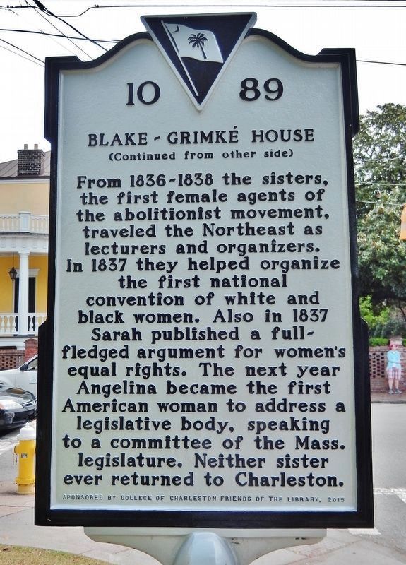
(side 1) This Charleston double house was built before 1789 by William Blake, a planter and descendant of former Proprietary Governor Joseph Blake. By 1803 Mary Smith Grimké, descendant of Landgrave Thomas Smith, and Judge John F. Grimké, a . . . — — Map (db m133687) HM
Founded 1818 by the Reverend Morris Brown
Closed by State Law 1834. Reopened By The Reverend R.H. Cain 1865
Present Edifice Built By The Reverend L.R. Nichols 1891
Redecoration By The Reverend F.R. Veal 1949
The Right Reverend F.M. Reid, . . . — — Map (db m219129) HM
Bicentennal
Historical Marker
Emanuel African Methodist Episcopal Church
Charleston, South Carolina
Commemorating the unique ministry of South Carolina born bishops, elected in the first century of the
Connection- . . . — — Map (db m52010) HM
The oldest African Methodist Episcopal (A.M.E.) church in the south, Emanuel A.M.E. Church was organized as
Hampstead Free African church in 1818 by Rev. Morris Brown. After seceding from the Methodist Church,
Charlestonians organized three . . . — — Map (db m51900) HM
The land now known as Liberty Square was once a place of arrival for survivors of the largest forced migration in world history. Gadsden's Wharf was the primary wharf for slave ships arriving in Charleston for 25 years, up until the banning of slave . . . — — Map (db m134227) HM
The National Register
of Historic Places
South Carolina
Department of Archives
And History
Charleston
Old E. Historic District
Harleston Boags Funeral Home
(Lower Plaque)
Harleston - Boags Funeral Home . . . — — Map (db m51484) HM
Philip Simmons is the most distinguished of Charleston ironworkers. Born on Daniel Island, Simmons began his eighty year career as a blacksmith at the age of thirteen under the apprenticeship of formerly enslaved Peter Simmons (no relation). Over . . . — — Map (db m134229) HM
Rice, Rattlesnakes, and Rainwater is a sculptural collection that explores the connections between Charleston's natural environment and its rich African-American history. The project consists of tabby (oyster-shell and concrete) houses and barrels . . . — — Map (db m135492) HM
Septima Poinsette Clark was born in Charleston, South Carolina in 1898, the daughter of Victoria Anderson of Haiti and Peter Poinsette, who grew up enslaved on the plantation of Joel Roberts Poinsette. Clark earned a teacher's certificate from The . . . — — Map (db m134228) HM
Native Charlestonian and daughter of a former lowcountry slave, Mrs. Septima Clark was a leader of the Civil Rights Movement. A graduate of Avery Normal Institute, Clark's first job was teaching African-American children on Johns Island. Her . . . — — Map (db m64797) HM
November 18, 1866 Bishop Patrick N. Lynch purchased a Jewish synagogue at 34 Wentworth Street and its adjacent property to establish a church for African American Catholics and approximately two years later he dedicated St. Peter's Catholic Church. . . . — — Map (db m31846) HM
1822 Organized as a place of worship for those
could not afford to rent pews in existing churches.
1824 Church built on Guingard St. as the first "free"
Church of the Episcopal Church in the United States. . . . — — Map (db m170910) HM
35 Calhoun Street was built in 1852 and occupied by Irish immigrants.
It was purchased by Willis Johnson, Sr. in 1939.
His sons, Frank and Henry built 35½ Calhoun with their own hands to complete
carpentry apprenticeships.
The houses . . . — — Map (db m53259) HM
35 Calhoun Street, was constructed in 1852
by Irish immigrants and purchased in 1939 by Willis
Johnson, Sr., who was born a free man at Drayton
Hall Plantation, West Ashley. 35 Calhoun Street and
35-1/2 are two-story wood framed . . . — — Map (db m171105) HM
Calvary Church was founded in 1847 to establish a special church for slaves in the Charleston community. Father Paul Trapier held services in March 1848 for the congregation in the basement of St. Philip's parsonage and in mid-July services were . . . — — Map (db m50924) HM
This church, located on Beaufain Street for 91 years, was organized in 1847 to give free blacks and slaves in
antebellum Charleston a separate Episcopal congregation of their own. The Rev. Paul Trapier was its first minister,
and the church . . . — — Map (db m50686) HM
Cannon Street Hospital Cannon Street Hospital, established here in 1897, served the African-American community of Charleston until 1959. Officially the Hospital and Training School for Nurses, it occupied a three-story brick building . . . — — Map (db m46344) HM
Celebrating over 130 years of providing a safe place for community residents to gather, play and learn.
What is now the Cannon Street Y was organized under the leadership of Harry W. Thomas in 1866. It was established using the name Charleston . . . — — Map (db m81291) HM
(Left panel)
Born in Luzerne County Pennsylvania - Son of Runaway Slaves - Grew up in Springfield, Pennsylvania and was
privately tutored and mentored by a Presbyterian minister who was active in the anti-slavery movement.
Educated . . . — — Map (db m52037) HM
The Parsonage“The Parsonage,” the home of Rev. James B. Middleton (1839-1918), stood here at 5 Short Court (now President’s Place) until 1916. Middleton and his siblings, born slaves, were taught to read and write by their father, . . . — — Map (db m39449) HM
This two and a half story house was built circa 1856 by Stephen S. Lloyd. Constructed in the form of a
Charleston single house, the basement level is brick, laid in American bond. The upper stories are of
wood with Greek Revival and Italianate . . . — — Map (db m81288) HM
Robert Smalls was born into slavery on April 5, 1839, in Beaufort, South Carolina. In 1851, he was sent to work in Charleston to earn money for his owner. At the age of 23, he was a crewman on the steamer Planter, an armed transport in . . . — — Map (db m94744) HM
Established in 1785 under the leadership
of Bishop Francis Asbury, the first Methodist
Society in Charleston purchased a lot in
Cumberland Street and erected a church
here in 1786. Long known as the Blue Meeting
House because of its color and . . . — — Map (db m47974) HM
Charleston was one of the largest slave trading cities in the U.S. In the 1800s, the area around the Old Exchange Building was one of the most common sites of downtown slave auctions. Along with real estate and other personal property, thousands of . . . — — Map (db m176650) HM
Theodore D. Wagner, an executive with the leading mercantile firm John Fraser & Co., constructed the building soon after purchasing the property in 1866. At the time, much of the surrounding community was damaged from Union shelling during the Civil . . . — — Map (db m187615) HM
Slave Rebellion Organizer
Born Circa 1767 - July 2, 1822
(front)
Denmark Vesey, previously named Telemaque, was born either in Africa or on the Caribbean island of St. Thomas. At the age of 14, he was purchased by the slave . . . — — Map (db m205440) HM
(front)
Hampton Park was once home to the Washington Race Course and Jockey Club. In 1864 this site became an outdoor prison for Union soldiers. Before Charleston fell in Feb. 1865, more than 250 prisoners died and were buried in mass . . . — — Map (db m205351) HM
Based on the English practice of housing the poor, the first act to establish a work house came locally in 1736. The first building, doubing as a public hospital, opened in 1738 at the southwest corner of Magazine and Mazyck (now Logan) streets. By . . . — — Map (db m206020) HM
In 1912, Julius P.L.Fielding established a funeral business on the northeastern corner of King and Queen Streets. In 1928, Julius acquired 122 Logan Street, a three-story Georgian style structure built in the 1700s with 12-inch thick exterior walls . . . — — Map (db m51443) HM
In 1891 the Reverend Daniel J. Jenkins established a home and school for poor, black orphans and for children of poor, distressed and disabled parents. It was his desire "to train the minds and hands of young, black boys and girls so that they could . . . — — Map (db m48701) HM
(front)
Jonathan Jasper Wright (1840-1885), the first African American in the U.S. to sit as a justice on a state supreme court, practiced law here from 1877 until his death in 1885. Wright, a native of Pa., was educated at Lancasterian . . . — — Map (db m206018) HM
(side 1) Septima Poinsette Clark, who Martin Luther King Jr. called "the Mother of the Movement," was a nationally influential Civil Rights activist. She was born at 105 Wentworth St. on May 3, 1898 to Peter Poinsette, a former slave, and . . . — — Map (db m133641) HM
(side 1)
This site once belonged to Hunter's Volunteers, an African American militia est. on James Island by 1877. Part of the S.C. National Guard, the unit kept an enlistment of 30-40 men tasked with helping preserve civil order. Most . . . — — Map (db m219423) HM
(Front text) This church, built in 1797 in the meeting-house form, was dedicated in 1798 and completed
in 1809. It is the oldest Methodist church standing in Charleston. Originally at the corner of Pitt and Calhoun
Streets, Bethel . . . — — Map (db m49375) HM
Old Bethel United Methodist Church, the third oldest church building surviving in Charleston, had its beginnings on February 14, 1797 as Bethel Methodist Episcopal Church. Bethel was constructed in the gabled meeting house style with white . . . — — Map (db m50297) HM
This present day garden design differs substantially from that which existed during the occupation of the property by the Russell Family and their slaves (1808-1857). In 1819 the Russell garden was described by an English visitor: ...called on the . . . — — Map (db m73186) HM
In January 1868 delegates met to rewrite the S.C. Constitution. They convened at the Charleston Club House, which once stood near here. Before the Civil War the Club House was reserved for Charleston's planter elite, but a majority of the delegates . . . — — Map (db m115228) HM
This three and one half story stuccoed masonry Adamesque single house with a two tiered piazza was constructed between September of 1811 and June of 1812 by George Keenan, a grocery merchant. The house was purchased in 1814 by Dr. Vincent Le . . . — — Map (db m47588) HM
This three-story stuccoed brick house was built sometime between 1778, the year of the great fire, and 1788. It stands on part of Lot 7 of the “Grand Modell” within the walled city of Charles Town and was the birthplace of Robert Tradd, who, . . . — — Map (db m187613) HM
The rear work yard of the Nathaniel Russell House was adjacent to the line of dependencies noted on this plat of the property from 1870.
The dependencies included the extant kitchen and laundry buildings that was at the center of most domestic . . . — — Map (db m73183) HM
Early on May 13, 1862, Robert Smalls, an enslaved harbor pilot aboard the Planter, seized the 149-ft.
Confederate transport from a wharf just east of here. He and six enslaved crewmen took the vessel before dawn
when its captain, . . . — — Map (db m62069) HM
U.S. Courthouse and Post Office (side 1)
This Renaissance Revival building, opened in 1896, is notable for its association with U.S. District Judge J. Waties Waring (1880-1968). Waring, a Charleston native who served here 1942 to 1952, . . . — — Map (db m133659) HM
Indentured servants and enslaved Africans were the backbone of the new colony, and their labor ensured its survival. Hundreds arrived in the years after 1670, and the new settlement must have included some sort of housing for this labor force. In . . . — — Map (db m67891) HM
The ruins of the Horry family home symbolize the Southern plantation system. Founded on this soil by the first colonists, the system flourished for generations, but ultimately crumbled. When the Lords Proprietors set up the colony, they copied the . . . — — Map (db m67878) HM
The ruins of the Horry family home symbolize the Southern plantation system. Founded on this soil by the first colonists, the system flourished for generations, but ultimately crumbled. When the Lords Proprietors set up the colony, they copied the . . . — — Map (db m67899) HM
In the clearing before you – although no visible signs remain – a row of six slave cabins may have stood. Written records reveal little about the slaves’ lives, but all plantations demanded hard field labor. Perhaps this row of small . . . — — Map (db m67903) HM
The town of Maryville, chartered in 1886, included the site of the original English settlement in S.C. and the plantation owned by the Lords Proprietors 1670-99. When the old plantation was subdivided into lots and sold to local blacks in the 1880s, . . . — — Map (db m16283) HM
Founded as a private school for elementary students in 1894 by Rev. John Dart at the corner of Bogard and Krake Streets, Charleston Normal and Industrial School was approved to become a public school for "colored" children in 1910 and opened at the . . . — — Map (db m39754) HM
(Front text)
This school, founded in 1910, was the first public high school for African-Americans in Charleston. It succeeded the Charleston Normal & Industrial School, a private school at Bogard & Kracke Streets, which had been founded . . . — — Map (db m39621) HM
Harmon Field (side 1)
Harmon Field, established in 1927, was one of many parks across the country created with support from the Harmon Foundation, a national philanthropic organization. Though dedicated to the "Recreation of All," state . . . — — Map (db m133635) HM
Camp of Wild's "African Brigade," 1863 - 1864. Folly Island was occupied by Union troops April 1863-February 1865. Gen. Edward A. Wild's "African Brigade" camped nearby from November 1863 to February 1864. The two regiments in Wild's brigade . . . — — Map (db m47153) HM
The Progressive Club, built in 1962-63, was a store and community center for Johns Island and other Sea Islands until it was badly damaged by Hurricane Hugo in 1989. The club had been founded in 1948 by civil rights activist Esau Jenkins . . . — — Map (db m95337) HM
Lincolnville School
Lincolnville School, the first public school for black students in this community, stood here from 1924 to 1953. Built at a cost of $6,100, it was one of more than 5000 schools in the South funded in part by the Julius . . . — — Map (db m223811) HM
Marker is on the farmhouse porch at north entrance):
Charles Pinckney National Historic Site honors Charles Pinckney honors Charles Pinckney of South Carolina, one of the drafters and signers of the Constitution of the United States. . . . — — Map (db m30544) HM
Edmund Jenkins Edmund Jenkins, a veteran of World War I, was the first elected black Town Marshal in Mount Pleasant, and served the Town from 1920-1927. He died December 26, 1930. His gravestone is directly to the left of this marker. The . . . — — Map (db m38036) HM
(Front text) This church, founded during Reconstruction, has been at the same site since 1890. The first sanctuary serving this congregation was located on Hibben Street and built on a lot leased by the Town of Mount Pleasant in 1877. After . . . — — Map (db m39427) HM
Side A At this site in 1881, Abby Munro, a Quaker from Philadelphia, established a home for orphans, neglected, and destitute children. Funds to purchase and operate the home were solicited locally and from friends in the North. It was . . . — — Map (db m38045) HM
Side A This community, settled along Horlbeck Creek in the 1870s by freedmen, was named after the Phillips Plantation. Former slaves of the Laurel Hill, Parker Island, and Boone Hall Plantations purchased the land in ten acre parcels and . . . — — Map (db m38049) HM
Riverside Beach Riverside Beach, developed by the Cooper River Bridge Company, opened in 1930 as the first black beach in the area. It was sold to the County in 1941. The site featured a dance pavilion, boardwalk, bath house, playground and ball . . . — — Map (db m38262) HM
In 1868, John Scanlon, a freedman, purchased 614 acres of the former Remley Plantation at auction for $6,100. He then founded the Charleston Land Company to provide land ownership to freed slaves. The tract was subdivided into a planned community . . . — — Map (db m38053) HM
Enslaved Africans once lived and labored at Snee Farm. This site is a remnant of a slave community that extended south, beyond today’s park boundary. The structures that once stood here were built of wood with post-in-ground foundations. Outlined . . . — — Map (db m67729) HM
Marker is off pathway, south of farmhouse:]
The Pinckney family owned Snee Farm from 1754 to 1817. Charles Pinckney inherited the property from his father in 1782. Snee Farm was one of Charles Pinckney’s seven plantations. At 715 acres it . . . — — Map (db m30804) HM
Enslaved Africans and their Gullah Geechee descendants lived and work on Snee Farm plantation from the 1700s to 1865. Before the Civil War, agricultural use shifted from rice and corn and other staples. Cotton appeared in the final decades of the . . . — — Map (db m224196) HM
Coil baskets of native sweetgrass and pine needles sewn with strips of palmetto leaf have been displayed for sale on stands along Highway 17 near Mount Pleasant since the 1930s. This craft, handed down in certain families since the 1700s, originally . . . — — Map (db m39038) HM
(Front): The Whilden House Elias Whilden, planter and mayor (1857-1858), built his home c. 1840. Five sons fought for the Confederacy, including John Marshall Whilden. John was Captain of the Citadel cadets who fired on the steamer, . . . — — Map (db m84068) HM
(side 1)
The Charleston Station was built in 1956 by the Atlantic Coast Line (ACL). ACL hoped the new station would attract customers, particularly tourists traveling on its Florida-bound trains. In 1967, ACL merged with Seaboard Air . . . — — Map (db m224508) HM
(side 1)
Embankments and ditches dating from the early 18th century are still visible here and show the elaborate layout of rice fields that were part of Windsor Hill and Woodlands plantations. Before the American Revolution, . . . — — Map (db m224505) HM
(Front text) Since 1937 this has been the campus of the Jenkins Orphanage, established in Charleston in 1891 by Rev. Daniel Joseph Jenkins (1862-1937). Jenkins, a Baptist minister, founded this orphanage for African American children with . . . — — Map (db m39336) HM
Liberty Hill, established in 1871, is the oldest community in what is now North Charleston. In 1864 Paul and Harriet Trescot, "free persons of color" living in Charleston, owned 112 acres here. They sold land to Ishmael Grant, Aaron Middleton, and . . . — — Map (db m39035) HM
Union Heights (side 1)This Community, subdivided into lots in 1919, was named for the nearby union station of three railroads. It had been part of Belmont Plantation from the colonial period to the mid-19th century and became an . . . — — Map (db m133628) HM
The Stono Rebellion, the largest slave insurrection in British North America, began nearby on September 9, 1739. About 20 Africans raided a store near Wallace Creek, a branch of the Stono River. Taking guns and other weapons, they killed two . . . — — Map (db m14855) HM
The Civil War Battle of Sol-Legare Island
July 16, 1863
In Honor of The Massachusetts 54th Regiment
During the Civil War (1861-1865) Sol-Legare Island
was the site of several camps, artillery positions
and battles. On this date, one . . . — — Map (db m30330) HM
[Marker Front]:
In this cemetery are the remains of some of Sullivan's Island's original Islanders, people of predominantly African American descent whose history parallels that of the Island.
Buried here are Carpenters, Cooks, . . . — — Map (db m19117) HM
A place where...Africans were brought to this country under extreme conditions of human bondage and degradation. Tens of thousands of captives arrived on Sullivan's Island from the West African shores between 1700 and 1775. Those who remained in . . . — — Map (db m19123) HM
Dr. Norris was born in Kingstree, S.C. to George and Arnette Norris.
Upon his arrival to Gaffney in 1914, he was one of the first Black Physicians to serve the community.
Dr. Norris served as President of the Piedmont Section of the . . . — — Map (db m247033) HM
Dunton Chapel Methodist Church can trace its origins to 1870 when Rev. J.R. Rosemond began preaching in the home of Milton Hardy. The church was built c. 1878, but has undergone many renovations, including being brick veneered in 1937. Originally . . . — — Map (db m196183) HM
Granard Graded and High School
This is the original location of Granard Graded and High School, also known as Granard Street School. It was built here between 1905 and 1914 and included the first black high school in Gaffney. The first high . . . — — Map (db m23967) HM
Glymph Memorial Garden is named in memory of Mr. Glymph who was born in Newberry, SC to George and Minnie Glymph. He was married to Dollie Ruff, and to their union, seven children were born. In 1920, Mr. Glymph moved his family to Gaffney and opened . . . — — Map (db m247030) HM
This African American church, the first in what is now Cherokee County, was most likely built between 1880 and 1890. It served the Whig Hill, Asbury, and Thickety communities of what was Union County before Cherokee County was created in 1897. . . . — — Map (db m19724) HM
In memory of
Burrel Hemphill
killed by
Union Soldiers
Feb. 1865
although a slave
he gave his life
rather than betray
a trust
He was a member of Hopewell — — Map (db m81337) HM
This institute grew out of an 1866 school for freedmen; it became Brainerd Institute in 1868 when the Board of Missions of the Presbyterian Church in New York appointed Rev. Samuel Loomis to help establish churches and schools among the blacks near . . . — — Map (db m14280) HM
St. Paul Baptist Church at HalsellvilleThis congregation, originally known as St. Paul Colored Baptist Church, was formally organized by 1884 on nearby Goings Road. The church moved to this location in 1901. Members acquired the land for . . . — — Map (db m246066) HM
Organized in 1881, this Negro Presbyterian (USA) school was founded by the Rev. J.P. Crawford with support from Mrs. C.E. Coulter from whom it received its name. The Rev. G.W. Long was academy president from 1908 until 1943, and Coulter offered . . . — — Map (db m18197) HM
John Birks "Dizzy" Gillespie was born in a house on this site on Oct. 21, 1917. His family lived here until they moved to Philadelphia in 1935. A founder of modern jazz, Gillespie was an innovative trumpeter and bandleader known for his bent . . . — — Map (db m28273) HM
[Front]
This church, formally organized in 1867, had its origins in Cheraw Baptist Church, founded in 1837. Shortly after the Civil War 285 black members there received permission to organize a separate church. Rev. Wisdom London, the first . . . — — Map (db m28271) HM
(Front text)
This church was founded about 1869 by Mary Scott “Aunt Mary” Harvin, and held its first services in a nearby brush arbor. In 1881 church trustees purchased a one-half acre lot here from Dr. J.G. Dinkins for . . . — — Map (db m51850) HM
(side 1)
Manning Training School has origins in the early 20th century with the Slater Fund helped finance Clarendon County Training School. This facility provided both education for black students and advanced training for African . . . — — Map (db m224599) HM
(Side 1)
Pearson Family Homesite
This farm was home to the family of Levi Pearson (1894-1970), who with his brother, Hammett Pearson, joined other African American parents in Davis Station and Jordan protesting Clarendon Co. . . . — — Map (db m199865) HM
Black institute built soon after school district purchased the land in 1933. School closed in 1953 with 5 teachers/ 159 students. Now a community center. — — Map (db m24158) HM
Liberty Hill ChurchIn 1867, five years after the Emancipation Proclamation, Thomas and Margaret Briggs gave four acres of land to this African Methodist Episcopal church. The present building, completed in 1905, has been brick veneered. Meetings . . . — — Map (db m24058) HM
"Together let us sweetly live" Distinguished Followers of Justice Briggs VS. Elliott Rev. Joseph A. Delaine; Mr. Hammett Pearson; Mr. Levi Pearson; Mr. Harry Briggs; Mr. Joseph Lemon; Pioneers in the School Desegregation Case; Historical plaintiffs . . . — — Map (db m52315) HM
(Side 1)
Briggs Family House
On November 11, 1949, local African American families came to this house to sign a petition demanding equal resources in Summerton's racially segregated schools. Believing the homes isolated location . . . — — Map (db m199859) HM
Mr. Harry and Eliza Briggs, a family of strong faith, were one of the first families to sign the petition. Meetings were held in their homes as well as St Mark AME, and Liberty Hill AME. These gatherings were held in secrecy to find twenty parents . . . — — Map (db m233255) HM
Mr. Levi Pearson, Sr. was a farmer and a humble man of strong faith and integrity, who believed in fairness. He initiated the fight to improve educational opportunities in Clarendon County in 1947 by asking Clarendon School District 26 to provide . . . — — Map (db m233256) HM
Described as courageous, fearless, confident, faithful, committed, humble and a man of integrity. The Rev. Joseph Armstrong De Laine was a pastor, principal and a great community leader who was the primary impetus behind the Clarendon County . . . — — Map (db m233254) HM
(Side 1)
Scott’s Branch School
Previously located at Taw Caw Baptist Church outside Summerton and at a site on 1st St., Scott's Branch School moved here 1937-38. The first school at this site was a white, ten room, frame building . . . — — Map (db m199855) HM
(Side 1)
In 1885, sixty-five former members of Liberty Hill A.M.E. Church. (3 mi. SE) organized this congregation to have a church closer to their homes. They first met in a small frame building that fronted Main Street. In 1905, members . . . — — Map (db m199851) HM
In 1885 this black baptist church bought the building here, said built about 1860, from white Taw Caw church,now Summerton. Building additions have been made over the years. — — Map (db m24131) HM
In tribute to all those who, casting away the shackles of servitude and the humiliation of bondage, accepted the sweet yoke of Christ and the light burden of his teachings in the Holy Catholic Church founded by Jesus upon Simon Peter the Apostle, . . . — — Map (db m7885) HM
500 entries matched your criteria. Entries 101 through 200 are listed above. ⊲ Previous 100 — Next 100 ⊳