After the Civil War, in the Red Oak area of Charlotte County, many freed slaves were welcomed to worship at Antioch Baptist Church, a traditionally white church. The Antioch congregation helped raise money to build Salem Baptist Church in . . . — — Map (db m30999) HM
After the Civil War, in the Red Oak area of Charlotte County, many freed slaves were welcomed to worship at Antioch Baptist Church, a traditionally white church. The Antioch congregation helped raise money to build Salem Baptist Church in . . . — — Map (db m182464) HM
Roosevelt Brown, Jr. (1932-2004) was born In
Charlottesville and played football at Jefferson High
School, the City’s only African-American High
School. Following a stellar career he attended
Morgan State University where he was named to
the . . . — — Map (db m30546) HM
Welcome to Historic Charlottesville
Charlottesville's rich historic legacy creates the City's unique sense of place and represent one of its primary economic and cultural asset. The City's character-defining historic resources include the . . . — — Map (db m170659) HM
Benjamin Ellis Tonsler (1854-1917) grew up enslaved by the Burnley family of Albemarle County. As a youth, he attended the Freedmen's School. Encouraged by his teachers, he attended and graduated from Hampton Institute in 1874, where he met his . . . — — Map (db m170142) HM
In 1962, Johnson Elementary School became the third Charlottesville public school to desegregate due to a lawsuit brought by the local chapter of the National Association for the Advancement of Colored People. Initially, to avoid court-ordered . . . — — Map (db m170144) HM
The Foster family kept their ancestors close. Sheltered on a portion of their 2 1/8-acre plot purchased in 1833 by free black Catherine Foster, this burial ground still contains several dozen graves.
Rediscovered in 1993, the Foster cemetery . . . — — Map (db m81599) HM
Traces of those who came before are all around us. This spot, for example, holds clues to the life of Catherine Foster, a free black seamstress and laundress, who purchased 2⅛-acres here, in 1833, for herself and her family.
As this . . . — — Map (db m81593) HM
At this place, on the site of Catherine Foster's home, this "shadow catcher" links the visible with the unseen even as it pulls the eyes upward to the sky. It creates a shadowy, gridlike outline of the house that once stood at this location. . . . — — Map (db m81598) HM
The University of Virginia, established in 1819 for white men only, rejected the application of Gregory Swanson (1924-1992) to its graduate school of law in 1950 because he was black. Swanson, a lawyer from Danville, filed suit with the support of . . . — — Map (db m198386) HM
Lynching in America. Thousands of African Americans were the victims of lynching and racial violence in the United States between 1877 and 1950. During this era, racial terror lynching of African Americans emerged as a stunning form of . . . — — Map (db m166184) HM
Lane High School. French Jackson, Donald Martin, John Martin.
Venable Elementary School. Charles E. Alexander, Raymond Dixon, Regina Dixon, Maurice Henry, Marvin Townsend, William Townsend, Sandra Wicks, Roland T. Woodfolk, Ronald E. . . . — — Map (db m64024) HM
The Daughters of Zion Cemetery was established in 1873 by a benevolent organization of African American women known as the Daughters of Zion, who purchased an approximate two-acre plot for African American burials located across from the segregated . . . — — Map (db m189586) HM
Jackson P. Burley High School is named in memory of Jackson Price Burley, a distinguished educator, church worker, and community leader. The school opened in September 1951 with twenty-six teachers, a principal, assistant principal, secretary, . . . — — Map (db m246902) HM
With reverence and steadfast hearts, we honor the memory of our beloved Burley High School and Mr. Jackson P. Burley. Minds were molded and shaped by the dedicated administrators, teachers and staff who guided us. The legacy of this grand . . . — — Map (db m246956) HM
The City of Charlottesville and Albemarle County opened Jackson P. Burley High School in Sept. 1951 to serve nearly 550 African American students. The 26-classroom building reflected an effort to provide "separate but equal" facilities in an era . . . — — Map (db m246901) HM
In 1951, Patterson, New Jersey native, Coach Robert "Bob" Smith, was tagged to build a sports program for Jackson P. Burley High School; a new negro high school run jointly by Charlottesville City and Albemarle County. Smith used his . . . — — Map (db m246900) HM
Washington, DC native, Walter “Rock” Greene, began his coaching career in 1957 as an assistant football and basketball coach under legendary Coach “Bob” Smith. Coach Greene became head coach to the Burley Bears basketball team in 1960. That year . . . — — Map (db m65229) HM
The Charlottesville African Church
congregation was organized in 1864. Four years later it bought the Delevan building, built in 1828 by Gen. John H. Cocke, and at one time used as a temperance hotel for University of Virginia students. It became . . . — — Map (db m8824) HM
The oldest part of the building known as Inge's Store, at 333 West Main Street, was constructed in 1820 and is one of the oldest buildings remaining on the Three Notch'd Road between downtown Charlottesville and the University. It is an example . . . — — Map (db m246925) HM
The name Jefferson School has a long association with African American education in Charlottesville.
It was first used in the 1860s in a Freedmen's Bureau school and then for a public grade school by 1894. Jefferson High School opened here in 1926 . . . — — Map (db m19834) HM
The origin of Mount Zion Baptist Church is traced back to the period after the Civil War. Although the founding fathers had roots in a white Baptist Church, in 1867 they began meeting independently from house to house. Soon thereafter . . . — — Map (db m246923) HM
Poverty and prejudice shaped the lives of African Americans in Charlottesville. In the 1920s African Americans made up 28 percent of the town's population but owned only 6.5 percent of its real estate. Many lived crowded together in very small . . . — — Map (db m170153) HM
The legacy of the Holt House endures beyond the life time of Charles B. Holt. Asalie Minor Preston (c. 1904-1962), a schoolteacher in Albemarle County's "colored" schools, married Holt's stepson and lived here after Charles B. Holt died in 1950. In . . . — — Map (db m170146) HM
African American Charles B. Holt owned a carpentry
business in Charlottesville’s Vinegar Hill neighborhood. The son of former slaves, Holt built this
Arts and Crafts-style house in 1925-1926, during
the era of segregation when blacks were . . . — — Map (db m30541) HM
Though he owned his home, Holt still had to contend with society's prejudice and unfairness. In 1929 Charlottesville adopted its first zoning ordinance. The city forbade business and industry from encroaching on residential neighborhoods, but did . . . — — Map (db m170156) HM
Charles B. Holt, the man who built this "Rock House" was born in 1872 in Alamance County, North Carolina. Holt's father and mother, Charles and Arena; his brother, George; and his sisters Rachel, Jane, and Margaret had all lived as slaves. In 1863, . . . — — Map (db m170159) HM
By 1900 the young Charles B. Holt had left his father's farm and moved to Charlottesville. Holt's skills and determination as a carpenter, builder, and entrepreneur helped him save enough money to buy land and build his home. — — Map (db m170163) HM
Holt built his bungalow in the Arts and Crafts style. This popular style connected the house with its natural site. The stone walls of the house and at the edges of the property united house and garden harmoniously. A covered porch strengthened . . . — — Map (db m170148) HM
The Holt House is an inspiration to people facing social prejudice and legal inequity. Charles B. Holt (1872-1950), born to former slaves in North Carolina, triumphed against the odds and achieved an American dream: home ownership. Holt's house is a . . . — — Map (db m170154) HM
Venable Elementary School.
Charles E. Alexander, Raymond Dixon, Regina Dixon, Maurice Henry, Marvin Townsend, William Townsend, Sandra Wicks, Roland T. Woodfolk, Ronald E. Woodfolk.
Lane High School.
French Jackson, Donald Martin, John . . . — — Map (db m65187) HM
After the abolition of slavery, African Americans still confronted racial prejudice. Schools, churches, transportation, parks, and other public spaces became segregated by practice and by law. In 1919 Paul Goodloe McIntire (1860-1952), a merchant . . . — — Map (db m170149) HM
You are standing on land once inhabited by the Monacan Indians and bison. While much of the landscape has changed, the Rivanna River still runs through, connecting past to present.
1733. The property first came into European hands in a . . . — — Map (db m172972) HM
In this vicinity, in 1775, was the southern end of a causeway, with bridges, by which the swamp and stream were crossed. Here William Woodford's Virginia riflemen defended the passage. When Lord Dunmore's British regulars attempted to cross the . . . — — Map (db m29926) HM
Justin Holland was a 19th-century pioneer African American of the classical guitar, community leader, and abolitionist. Born in Norfolk County about 1819, he left for Massachusetts in 1833. There he took music lessons and learned to play the guitar. . . . — — Map (db m76794) HM
James Edward Owens and Grace Catherine Melvin Owens, the college-educated children of formerly enslaved people, built this Queen Anne-style house ca. 1915. Their son Hugo Armstrong Owens, dentist and civil rights activist, was born here in 1916. . . . — — Map (db m211946) HM
This is the Deep Creek Lock of the Dismal Swamp Canal, the northern end of the waterway linking the North Carolina sounds with Hampton Roads and the Chesapeake Bay. Deep Creek village evolved on the canal to serve workers, boatmen, and the . . . — — Map (db m165286) HM
This memorial is the first and only memorial of its kind in the Commonwealth of Virginia dedicated to honor Afro-Union patriot heroes. It is located in the northeast section of the Sgt. March Corprew Family Memorial Cemetery.
Sgt. March . . . — — Map (db m211252) HM
His courage “amid a shower of bullets” helped achieve victory at the Battle of Great Bridge.
Private William (Billy) Flora was a free black from the Portsmouth area and a member of the Norfolk County Militia who served as a . . . — — Map (db m54952) HM
“…to reduce this colony to a proper sense of their duty…to His Majesty’s crown and dignity…”
On November 15, 1775, the day after his success in routing the rebels at Kemp’s Landing, Lord Dunmore issued a proclamation declaring . . . — — Map (db m54942) HM
Thirteen African American veterans of the Civil War are interred nearby at the Cuffeytown Historic Cemetery. They served in the 5th, 10th, and 36th United States Colored Troops infantry regiments organized in 1863 and 1864, after the Emancipation . . . — — Map (db m48917) HM
Across the canal lies the US Fish & Wildlife Service's Great Dismal Swamp National Wildlife Refuge.
The Great Dismal Swamp was once a vast ecosystem that covered as much as one million acres of southeastern Virginia and northeastern . . . — — Map (db m114525) HM
Nearby were the homes of three Afro-Virginians who served in the United States Colored Troops (USCT) during the Civil War. Sgt. March Corprew, Co. I, 2nd USCT Cavalry, and his brother Pvt. Daniel Corprew, Co. D, 1st USCT Cavalry, lived on a . . . — — Map (db m48918) HM
After African American patrons campaigned for a new high school, the Chesterfield County School Board opened the consolidated George Washington Carver High School here in 1948. Carver, which replaced the old Hickory Hill and Daniel Webster Davis . . . — — Map (db m149856) HM
(preface) Early in 1864, Union Gen. Ulysses S. Grant, commander of all Federal armies, ordered advances throughout the Confederacy in the spring. On May 5, Union Gen. Benjamin F. Butler landed his Army of the James on Bermuda Hundred . . . — — Map (db m164324) HM
Like its pre-war economy, much of the southern war effort relied on slave labor. When Richmond became the capital for the newly formed Confederacy, both freedmen and slaves were used to maintain railroads, build fortifications, and perform other . . . — — Map (db m109390) HM
Thousands of African-American troops served in the Army of the James under the official designation of United States Colored Troops (USCT).
Maj. Gen. Benjamin F. Butler was a strong proponent of the use of African-American troops and had more . . . — — Map (db m180820) HM
"The Rocks" became a popular place for students to meet down on the Appomattox River. The group seen here is from the "Normal Class" of 1913. The term "normal" referred to teacher training programs. The "collegiate institute" included training in . . . — — Map (db m149617) HM
Lynchburg native Amaza Lee Meredith was one of the nation's few African American female architects during the mid-20th century. Her self-designed residence, Azurest South (1939), is a rare Virginia example of a mature International Style building. . . . — — Map (db m130078) HM
Frederick Francoz Simms was born to Frederick H. and America T. Ayer Simms on May 8, 1884 in New Orleans Parish. A graduate of Southern University and Agricultural and Mechanical College, commonly known today as Southern University in Baton . . . — — Map (db m149605) HM
Project Overview: In 1907, the trustees of what is now Virginia State University voted to build a new President's residence at a cost of $3,300. Named for the school's first principal, James Storum, Storum Hall is the University's oldest . . . — — Map (db m149622) HM
Project Overview: Vawter Hall was named for Captain Charles E. Vawter, a life-long educator and Chairman of the board of the Virginia Normal and Industrial Institute Board of Trustees from 1902 until his death in 1905. Constructed in 1908, it . . . — — Map (db m149619) HM
The Virginia State Normal School, now Virginia State University, purchased a two-acre tract with a mill building from John Stearns for the sum of $35,000 in 1922. The mill was used for silk dying and weaving and was one of many water powered mills . . . — — Map (db m149612) HM
Simms Hall was used to educate tradesmen. This is the only remaining structure from the building. It is believed to be a demonstration of the art of masonry. — — Map (db m149610) HM
Virginia State University was founded on March 6, 1882, when the legislature passed a bill to charter the Virginia Normal and Collegiate Institute. The bill was sponsored by Delegate Alfred W. Harris, a Black attorney whose offices were in . . . — — Map (db m149618) HM
Virginia State University was chartered by the Virginia legislature in 1882 as the Virginia Normal and Collegiate Institute. Delegate Alfred W. Harris, an African-American attorney in Petersburg, championed the charter and supported it . . . — — Map (db m26005) HM
Virginia State University was chartered by the Virginia legislature in 1882 as the Virginia Normal and Collegiate Institute. Delegate Alfred W. Harris, an African American attorney in Petersburg, championed the charter and supported it . . . — — Map (db m180147) HM
The Virginia Normal and Collegiate Institute was chartered on 6 Mar. 1882. The Readjuster Party was instrumental in supporting a state institution of higher education in Virginia for African Americans with some unusual features to the institute's . . . — — Map (db m26007) HM
First African Baptist Church of Coalfield, which stood about a mile southeast of here, opened a school for African Americans in 1866. After a fire in 1877, the congregation moved here and renamed itself First Baptist Church in Midlothian. Church . . . — — Map (db m180215) HM
Early History of the Grove Shaft
1836-61
The Grove Shaft plunged 625 feet and took workmen three years to dig. The Wooldridges employed 150 men and boys. Twenty-five mules stabled underground pulled coal carts on an underground railroad. . . . — — Map (db m31570) HM
The Mid-Lothian African Church
Near the Grove Shaft, 54 free blacks, slaves and six white males at the Mid-Lothian Coal Mining Company started the Mid-Lothian African Church on February 8, 1846. Assisted by the company the 60 member . . . — — Map (db m31571) HM
Coal Mining Chronology in Chesterfield
1835 Mid-Lothian Coal Mining Company is chartered.
1836 The Company organizes with 3,000 shares valued at $100 each with 1,000 shares being sold to raise $100,000 capital. The Wooldridge family . . . — — Map (db m31572) HM
Bethlehem Baptist Church, first known as Cox's Meeting House and then Spring Creek Church, was formally organized several miles northwest of here in 1790. Founding pastor Benjamin Watkins served for 41 years. African Americans constituted a . . . — — Map (db m170046) HM
On 26 Feb. 1921, Delta Omega became the first graduate chapter of Alpha Kappa Alpha Sorority Inc. chartered on the East Coast, the fourth graduate chapter in the U.S., and the first Greek-letter organization at Virginia Normal and Industrial . . . — — Map (db m224396) HM
Clarke County is proud to be home to two historic driving tours. They include all four of our historically designated towns and villages. Combined with the National Register Historic Districts of which they are part, they make up over 38 percent . . . — — Map (db m157718) HM
To improve the lives of former slaves, Ellen McCormick, widow of Edward McCormick of Clermont, established this African American community of 31 one-acre lots early in the 1870s. The lots, laid out on either side of the 16-foot-wide street that . . . — — Map (db m1805) HM
Early in the 1870's African Americans established Josephine City, a community originally composed of 31 one-acre lots lining a 16-foot-wide street. Twenty-four former slaves and free blacks purchased the lots at $100 an acre from Ellen McCormick, . . . — — Map (db m85942) HM
Much of Clarke County was literally built by enslaved Africans. The 1840 census revealed 55 percent of the County's population was "colored". Those men, women, and children, whose forebearers came as property came as property of the first . . . — — Map (db m157720) HM
This 16-square-mile scenic landscape illustrates the changing patterns of rural life since the 1730s as shown in its plantations, farms, mills, churches, and African American communities. The first settlers came from various places, including New . . . — — Map (db m5595) HM
Lucy Slowe, educator, was born in Berryville.
In 1908, while attending Howard University,
she became a founding member of Alpha Kappa
Alpha Sorority, the first Greek letter organization
for African American women, and was elected
its first . . . — — Map (db m104725) HM
In 1882, the former slaves and free colored people of this community built the Josephine City School to provide their children with a grade school education. Under the leadership of Rev. Edward Johnson, a new building was completed in 1930 to . . . — — Map (db m5513) HM
This 30-square-mile scenic landscape illustrates the evolution of a unique rural community. Unlike the rest of the Shenandoah Valley, where mostly Scots-Irish and German immigrants settled on small farms, Virginia Tidewater gentry occupied most of . . . — — Map (db m1848) HM
The area to the south was the center of commerce in the early 1900’s. It was here that retail shops, repair shops, hardware stores, restaurants, hotels and services flourished. In this era, blacks owned and operated nearly half the businesses in the . . . — — Map (db m8637) HM
The Eckington School was built in 1895 as
a frame, one-room school for African American
students from the nearby communities of
Eckington and Poplar Ridge. The school
building is typical of the ungraded schools of
the 19th century that had all . . . — — Map (db m59522) HM
This area of Downtown Culpeper is historically known as "Sugar Bottom," home to many of Culpeper's black Americans around 1900. Former residents refer to this enclave as a friendly neighborhood, where everybody knew everybody, the church was the . . . — — Map (db m170189) HM
Madden's Tavern is located south of this site and was completed circa 1852. Willis Madden, a free black man, owned and operated the log structure. Madden also built a general store, a blacksmith and wheelwright shop, and drover's rest on the . . . — — Map (db m185515) HM
On May 8, 1864, following the Battle of the Wilderness, troopers of the 9th Virginia Cavalry scouted through this region and captured several United States Colored Troops (USCTs) near Madden's Tavern. Private Byrd C. Willis of the 9th recalled, . . . — — Map (db m185516) HM
George Washington Carver Regional High School was founded in 1948 to serve the educational needs of black students in Culpeper, Madison, Orange, and Rappahannock counties. Secondary schools for blacks in those counties were either nonexistent or . . . — — Map (db m4455) HM
John Preston "Pete" Hill, Negro League baseball player and manager, was born nearby on 12 Oct., probably 1882, and likely to formerly enslaved parents. Banned from whites-only major leagues, Hill became a star outfielder for African American teams, . . . — — Map (db m170707) HM
Founded in 1782, Stevensburg sits at the important intersection of the Old Carolina Road and Kirtley Road - the intersection where you now stand. The community is named for General Edward Stevens, a local Revolutionary War leader and state . . . — — Map (db m152625) HM
Before the creation of independent African American churches throughout Virginia, the enslaved often attended church with their owners. Laws regulating African American gatherings and worship became increasingly strict in the 1830s following "Nat . . . — — Map (db m152626) HM
Parents in the Cartersville area of Cumberland County met in 1909 to discuss the need for a centralized high school to replace the one-room schools serving white children in the area at that time. The county Superintendent of Schools led the . . . — — Map (db m31609) HM
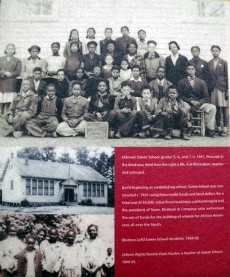
Julius Rosenwald, a former president of Sears, Roebuck & Co., continued the efforts made by numerous philanthropists to bring education to African Americans in the South. During the early 1900s, funding for schools was scarce; the South had half . . . — — Map (db m21159) HM
Jackson Davis, an educational reformer and amateur photographer, was born in Cumberland County, VA, to William Anderson and Sally Wyatt (Guy) Davis on September 25, 1882. He attended the public schools of Richmond, VA, and received his B.A. . . . — — Map (db m21150) HM
Jackson Davis, an educational reformer and amateur photographer, was born in Cumberland County, VA, to William Anderson and Sally Wyatt (Guy) Davis on September 25, 1882. He attended the public schools of Richmond, VA, and received his BA . . . — — Map (db m171696) HM
The Rev. Reuben T. Coleman, enslaved at birth, became an entrepreneur after the Civil War. About 1.5 miles north of here he established Lucyville, named for his daughter, which in the 1890s featured a bank, post office, newspaper, and mineral . . . — — Map (db m247281) HM
James F. Lipscomb was born a free black on 4 December 1830 in Cumberland County. He worked first as a farm laborer, then as a carriage driver in Richmond. In 1867 he returned to Cumberland County, where he accumulated more than 500 acres of land. . . . — — Map (db m30244) HM
Samuel P. Bolling was born enslaved in Cumberland County and became a skilled mechanic. After the Civil War he purchased several lots in Farmville, where he established a successful brickyard by 1874. He later acquired more than 1,000 acres in . . . — — Map (db m238093) HM
In the spring of 1963 local African American ministers and other leaders organized the Danville Movement to combat widespread racial segregation and discrimination. On 10 June, two demonstrations occurred. Police clubbed and fire-hosed the marchers, . . . — — Map (db m66038) HM
Caswell County, North Carolina, was established in 1777 and named for Richard Caswell, the state's first governor. It is located on the northern border of North Carolina adjoining Danville, Virginia.
Attractions
Caswell County Civic . . . — — Map (db m171900) HM
First State Bank, one of the few banks in Virginia owned by African Americans, opened on 8 Sept. 1919 as the Savings Bank of Danville. By issuing loans to individuals, businesses, and churches, the bank fostered the black community's vitality during . . . — — Map (db m171809) HM
The Holbrook-Ross Historic District, named for two major streets, is significant as the first neighborhood in Danville for African American professionals. Lawyers, ministers, dentists and physicians, as well as, business owners, insurance agents, . . . — — Map (db m66044) HM
The Loyal Street Baptist Church congregation, which was organized between 1865 and 1866 on Old Hospital-Dance Hill by former slaves, built its church here in 1870. Worship continued at this site until 1924 when the congregation moved to Holbrook . . . — — Map (db m66036) HM
Born near here in Dinwiddie County in 1818, Elizabeth Hobbs Keckley, or Keckly, was a
dressmaker and abolitionist. She lived as a slave in Virginia and North Carolina but
eventually bought her freedom in 1855. By 1860 she had relocated to . . . — — Map (db m79076) HM
British Lt. Gen. Charles Cornwallis ordered cavalry commander Lt. Col. Banastre Tarleton to raid Southside Virginia in the summer of 1781. Tarleton left Surry County before turning back. His objective was to destroy stores of ammunition, clothing, . . . — — Map (db m180009) HM
Dinwiddie Normal Industrial School, the first African American high school built in the county during the segregation era, stood three miles southeast. When the building burned in 1953, plans were already in progress to construct a modern facility . . . — — Map (db m79077) HM
Prior to the Civil War, Dinwiddie County was home to several private academies for those who could afford to pay for their education. While it was mostly affluent males who were educated, Pegram’s Academy, Female Academy, Girard Heartwell . . . — — Map (db m26834) HM
1625 entries matched your criteria. Entries 301 through 400 are listed above. ⊲ Previous 100 — Next 100 ⊳