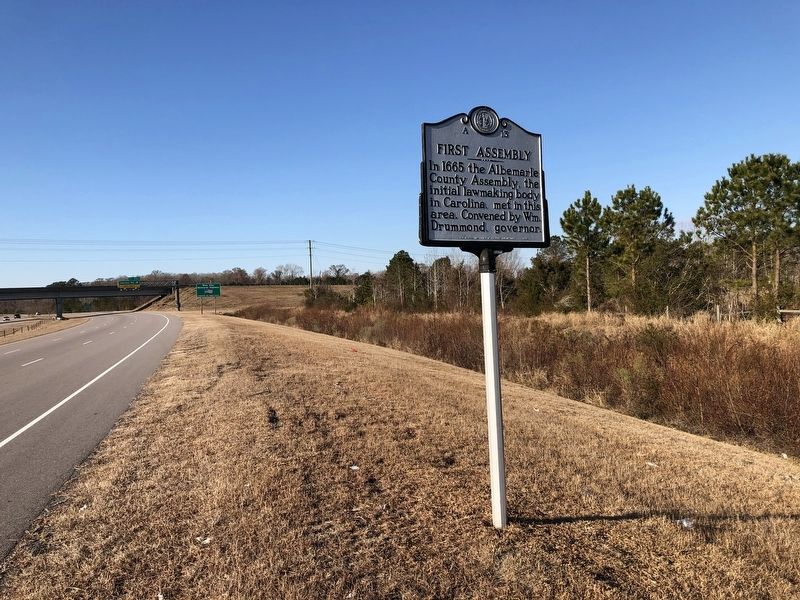
On Old Okisko Road (U.S. 17) 0.1 miles north of Oskisko Road (County Road 1140), on the right when traveling south.
In 1665 the Albemarle County Assembly, the initial lawmaking body in Carolina, met in this area. Convened by Wm. Drummond, governor. — — Map (db m165284) HM
On East Main Street at North Elliot Street, on the right when traveling west on East Main Street.
Fifth Courthouse in County; second on this site. Replaced wooden building erected about 1799 and burned during Federal occupation of the City, 1862. Records dating from about 1700 were saved by Arthur Jones and hidden in a barn until end of war. — — Map (db m56775) HM
On U.S. 117 close to Business U.S. 117, on the right when traveling north.
Named by Barbadian explorers, 1663. Home of Gov. George Burrington and Samuel Strudwick, colonial official. The house stood ¾ miles east. — — Map (db m30203) HM
On U.S. 117 just south of Interstate 40, on the left when traveling south.
U.S. Senator, 1795–1801; member, U.S. House, in First Congress, 1790–91. Opposed ratification of U.S. Constitution, 1788, 1789. Lived near here. — — Map (db m28613) HM
On North Main Street at West Morehead Street, on the left when traveling north on North Main Street.
1888 - 1908: Practiced Law in Person County
1896 - 1908: U.S. House of Representatives Fifth Congressional District
1909 - 1913: Governor, State of North Carolina — — Map (db m171745) HM
On South Main Street just south of Court Street, on the right when traveling south.
The current courthouse structure, circa 1932, is the third courthouse built on this site. The original land conveyance occurred in 1792 and consisted of 6 acres donated to Person County by Dempsey Moore, "in consideration of the good-will of the . . . — — Map (db m218123) HM
On Boston Road (U.S. 501) 0.6 miles north of Old U.S. 501, on the right when traveling north.
Two worthy servants of God. Leading educators, benefactors, and distinguished citizens of Person County for more than half century.
Mr. Beam born in Cleveland County, graduated at Wake Forest College. Founder of Bethel Hill Institute 1888. . . . — — Map (db m171740) HM
On Oxford Road (U.S. 158) at Surf Mount Tizrah Road (County Road 1717), on the right when traveling east on Oxford Road.
Founder, 1870, of Webb School, since 1886 in Bell Buckle, Tenn. Confederate soldier, U.S. Senator, 1913. Born 1842, one mile S. — — Map (db m218135) HM
Baty Hall was a faithful and dedicated public official, having served the citizens of Polk County and the city of Saluda in a stately manner.
He served as chairman of Polk County board of commissioners from December 3, 1956 to December 3, 1968, and . . . — — Map (db m44681) HM
On Worth Street west of North Cox Street, on the right when traveling west.
Randolph County was formed in 1779, and its government met at the lost town of Johnstonville in New Market Township from 1786 to 1792. After residents petitioned for a more convenient location “in the most central part” of the county, the state . . . — — Map (db m234004) HM
On Red Fox Road, 0.1 miles south of Welborn Road (North Carolina Road 1564), on the right when traveling south.
Built circa 1780 by Jeduthan Harper,
signer of Halifax Resolves (April 12, 1776);
Lt. Col., Chatham County Minute Men;
appointed by N.C. Provincial Congress to
supervise cannon ball manufacturing for
the American Revolution; later Clerk . . . — — Map (db m239083) HM
On South Lee Street at East Franklin Street, on the right when traveling north on South Lee Street.
From 1889 Richmond
County court house once
standing one block north.
Restored in honor of those
who serve and have served
Richmond County
in court house offices
and the judicial center. — — Map (db m244630) HM
On Fayetteville Road at Goodwin Avenue, East 24th, and North Cedar Streets, on the left when traveling south on Fayetteville Road.
Founder of Lumberton, captain in Revolution, later brigadier general; member of legislature, conventions of 1788, ’89. Plantation was here. — — Map (db m102264) HM
On West Railroad Street west of North Odum Street, on the left when traveling west.
Sponsored legislation in 1885 establishing public schools for Indians of Robeson County. In 1887 he introduced legislation to establish Croatan Normal School — now Pembroke State University. — — Map (db m102253) HM
On State Highway 704 at Smothers Road, on the left when traveling east on State Highway 704.
Presidential nominee, 1860, United States Senator from Illinois, was married to Martha Martin, 1847, in house standing 2 miles N.E. — — Map (db m62989) HM
On South Scales Street at Settle Street, on the right when traveling south on South Scales Street.
Governor, 1851-54, U.S. Senator, Congressman, member of peace conference, 1861, and of state conventions, 1861, 1875. Home stands 2 blocks E. — — Map (db m211442) HM
On State Highway 152, 0.1 miles east of Meredith Lane, on the right when traveling east.
Introduced bill, 1885, for industrial school, now N.C. State University. Speaker of House, 1889: prison reformer. Taught at academy here. — — Map (db m237131) HM
On West Innes Street just north of South Main Street (U.S. 29/70), on the left when traveling west.
Friendless, penniless, and above, he took his own life, and died at the age of eighty — this man who had shaken the Republic from center to circumference and who at a critical period had held and filled the center of the stage. . . . — — Map (db m175792) HM
On East Innes Street just east of South Main Street (U.S. 29/70), on the right when traveling east.
John Willis Ellis was born November 20, 1820, in the area of Rowan County which later became a part of the new county of Davidson. In 1842 he opened his law office at No. 2 Cowan's Row, located in this block. Early in his career he won a seat in . . . — — Map (db m175778) HM
On W Innes Street at S Ellis Street, on the left when traveling west on W Innes Street.
United States Senator, 1903-30, a leading supporter of Wilson’s war policies, Speaker of the House of Representatives. His home is here. — — Map (db m34286) HM
On South Church Street just south of West Fisher Street, on the right when traveling south.
Dug in the mid-1700s, it was last used by the A.H. Boyden family in the early 1900s. The well was the source of water for those who resided on this property, notably the familes of Adlai Osborne, Archibald Henderson, and Spruce Macay, along with his . . . — — Map (db m175784) HM
On Depot Street at North Main Street (North Carolina Road 1006), on the right when traveling south on Depot Street.
Some history records that President Abraham Lincoln was born in a
one-room cabin in Kentucky. However, N.C. research historians and
generational stories hold that Lincoln was born on Puzzle Creek, near
Bostic, North Carolina, and that his father . . . — — Map (db m240784) HM
This park is dedicated to Barbara T. Meliski who served on Chimney Rock Village Council as Mayor Pro Temp from the date of incorporation in July 1991 until 2005, and as Mayor from 2005 until her retirement from office in November 2015. A passionate . . . — — Map (db m92054) HM
On East Main Street at North Wall Street, on the left when traveling east on East Main Street.
Lieut. colonel militia, member Provincial Congress, 1775, legislature, conventions 1788, 1789. This town named for him. Home was nearby. — — Map (db m114364) HM
On Hobbtown Highway (U.S. 701) at Cedar Point Road (State Highway 1845), on the right when traveling north on Hobbtown Highway.
Congressman from N.C., 1811-16; Senator from Alabama for 29 years. Vice-President of the United States, 1853. Born six miles east. — — Map (db m79994) HM
On Business U.S. 74 at Rocky Ford Roud, on the right when traveling east on U.S. 74Business . Reported permanently removed.
Begun 1785. Congressman James Stewart gave land. J. C. McLaurin, who founded Laurinburg, and many Scots buried here. Two miles southwest. — — Map (db m56172) HM
On East Main Street at North Second Street, on the right when traveling west on East Main Street.
By 1843, this corner of the old town square contained the county's first log jail, whipping post, and stocks. In 1893, Stanly County's second courthouse (pictured), a tall, two-story, Victorian-style building, was constructed on this site. Even . . . — — Map (db m245426) HM
On Main Street (State Highway 89) at Courthouse Circle, on the left when traveling east on Main Street.
Governor of Alabama, 1829-1831. Served in U.S. House and Senate. Official of Mississippi and Alabama Territories. Born near here, 1785. — — Map (db m34435) HM
On West Oak Street just west of North Main Street, on the left when traveling west.
L.H. Jones was a leader and educator in Surry County for over 45 years. He served as the only principal of J.J. Jones High School during its 30-year existence between 1936 and 1966. The school was named after his father who worked as a teacher and . . . — — Map (db m185333) HM
Chief of Oconaluftee Cherokee. He advocated temperance and opposed removal of his people from their homeland. Lived in this vicinity. — — Map (db m12694) HM
Nature forged the Great Smokies, but the hands of the Civilian Conservation Corps (CCC) helped shape the national park we know today. During the 1930s, enrollment peaked as 4,300 men worked here, building roads, campgrounds, trails, and buildings. . . . — — Map (db m99065) HM
On East Jefferson Street at North Beasley Street, on the right when traveling west on East Jefferson Street.
Governor, 1917-21, first in state nominated by a Democratic primary. N.C. Attorney General, state legislator. Birthplace was 50 ft. north. — — Map (db m42550) HM
On North Carolina Route 39 just north of Stagecoach Road (County Road 1329), on the left when traveling north.
Eighteenth century town, named for John Williams, judge, state legislator, congressman, who lived nearby. Old St. John's Church is here. — — Map (db m221987) HM
On East North Street at N Blount Street, on the right when traveling west on East North Street.
Henry Clay, on a visit to this city, wrote the famous Raleigh Letter, April 17, 1844, opposing the annexation of Texas. Many authorities believe that this statement cost him the presidential election of 1844. According to tradition Clay wrote the . . . — — Map (db m63175) HM
Official residence, N.C. governors, it was completed 1891 on Burke Square using prison labor. Architects, A.G. Bauer & Samuel Sloan. — — Map (db m32553) HM
On South McDowell Street south of West Hargett Street, on the left when traveling north. Reported permanently removed.
Editor, author, public official
Son of
Josephus Daniels and Mary Cleaves Seabrook
Born in Washington, N.C.
May 18, 1862
Married to Addie Worth Bagley of Raleigh
May 2, 1888
Died in Raleigh, N.C.
January 15, 1948 . . . — — Map (db m217457) HM
On Church Hill Road (U.S. 158) at Church Hill Road (North Carolina Highway 1335), on the right when traveling west on Church Hill Road.
Governor, 1814-1817; state legislator and attorney general; U.S. Charge d'Affaires to Central America. Lived three miles north. — — Map (db m222553) HM
On South Main Street (U.S. 401) at Cousin Lucy's Lane, on the right when traveling south on South Main Street.
Member Continental Congress, United States Senator, 1789-1795, U.S. Indian Agent to the Creek Nation, 1796-1816. Home was 5½ mi. S.W. — — Map (db m222561) HM
On Mt Tabor Road at Arnold Hill Road, on the right when traveling west on Mt Tabor Road.
Colonial home of Daniel Davenport, farmer, surveyor, and first Senator from Washingtyon County. He served in the Revolutionary War. Homestead 3 miles -> — — Map (db m57044) HM
The State Legislature approved our town charter in 1889, and it allowed for
regulation of the sale of beer and wine. Our first Mayor, Joe Clark (who was
known to enjoy a drink), allowed Thornton Ingle to open a tavern, and the good
times began, . . . — — Map (db m229065) HM