After filtering for Wisconsin, 214 entries match your criteria. Entries 101 through 200 are listed.⊲ Previous 100 — The final 14 ⊳
Education Topic
By Paul F, January 5, 2011
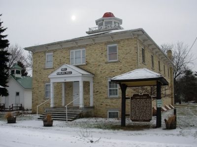
Albion Academy Marker
| 101 ► Wisconsin, Dane County, Town of Albion — 95 — Albion Academy — |
| On Campus Lane, 0.1 miles west of Edgerton Road (Wisconsin Highway 106), on the left when traveling west. | |||
| 102 ► Wisconsin, Dane County, Town of Albion — Sheepskin School — 1865 to 1959 — |
| On Campus Lane north of Edgerton Road, on the left when traveling north. | |||
| 103 ► Wisconsin, Dane County, Town of Burke — Token Creek Sedge Meadow Trail — |
| On Token Creek Lane, on the right when traveling north. | |||
| 104 ► Wisconsin, Dodge County, Beaver Dam — 109 — Wayland Hall — |
| On North University Avenue at Park Avenue, on the right when traveling north on North University Avenue. | |||
| 105 ► Wisconsin, Dodge County, Mayville — 98 — The Mayville White Limestone School Building — |
| On North Main Street at Buchanan Street, on the right when traveling south on North Main Street. | |||
| 106 ► Wisconsin, Dodge County, Watertown — Northwestern College — |
| On North Fourth Street at Lincoln Street, on the right when traveling south on North Fourth Street. | |||
| 107 ► Wisconsin, Door County, Egg Harbor — Site of Carlsville School District No. 3 — 1868 Marks the First Carlsville School — |
| On Wisconsin Route 42 at County Route I, on the right when traveling north on State Route 42. | |||
| 108 ► Wisconsin, Door County, Ellison Bay — 590 — The Clearing — |
| On Garrett Bay Road. | |||
| 109 ► Wisconsin, Door County, Ephraim — Gibraltar District School No. 2 — National Register of Historic Places — |
| On Moravia Street north of Church Street, on the right. | |||
| 110 ► Wisconsin, Door County, Sister Bay — Old Schoolhouse No. 2 — |
| On Bay Shore Drive (Wisconsin Route 42) at Gateway Drive, on the right when traveling north on Bay Shore Drive. | |||
| 111 ► Wisconsin, Douglas County, Superior — 320 — The University of Wisconsin-Superior — |
| On Catlin Avenue, 0.1 miles south of Belknap Street (U.S. 2), on the right when traveling south. | |||
| 112 ► Wisconsin, Dunn County, Menomonie — Bell Monument — |
| 113 ► Wisconsin, Dunn County, Menomonie — Gateway to the Historic Corridor — |
| On East Main Street (State Highway 29), on the right when traveling east. | |||
| 114 ► Wisconsin, Eau Claire County, Eau Claire — Eau Claire Public Library — City of Eau Claire Landmark Commission — |
| On South Farwell Street north of East Grand Avenue, on the right when traveling north. | |||
| 115 ► Wisconsin, Eau Claire County, Eau Claire — Swift-Wing Home — 1233 Graham Avenue — City of Eau Claire Landmark Commission — |
| On Graham Avenue south of Washington Street, on the left when traveling south. | |||
| 116 ► Wisconsin, Fond du Lac County, Ripon — 184 — Ripon College — |
| On Ransom Street north of West Blossom Street, on the right when traveling south. | |||
| 117 ► Wisconsin, Grant County, Bagley — Curtis Memorial Scientific Area — John Thomas Curtis — 1913-1961 — |
| On State Park Lane, on the right when traveling north. | |||
| 118 ► Wisconsin, Grant County, Platteville — 276 — First State Normal School — |
| On Main Street at Elm Street, on the right when traveling west on Main Street. | |||
| 119 ► Wisconsin, Grant County, Platteville — Major John Roundtree House — |
| Near Rountree Avenue just south of East Pine Street (State Highway 81), on the right when traveling south. | |||
| 120 ► Wisconsin, Grant County, Platteville — Ullrich Hall — |
| Near University Plaza (West Pine Street), 0.1 miles west of South Hickory Street. | |||
| 121 ► Wisconsin, Grant County, Platteville — Vietnam War Memorial — University of Wisconsin-Platteville — |
| Near West Pine Street just west of South Hickory Street. | |||
| 122 ► Wisconsin, Grant County, Platteville — World's Largest M — Symbol of the College of Engineering — |
| On West Mound Road at County Route B, on the right when traveling north on West Mound Road. | |||
| 123 ► Wisconsin, Grant County, Platteville, Downtown — Platteville Carnegie Library — |
| On Market Street just east of North Chestnut Street (State Highway 81), on the left when traveling east. | |||
| 124 ► Wisconsin, Iowa County, Mineral Point — 433 — Laurence F. Graber — "Mister Alfalfa" — |
| On Fair Street, on the left when traveling west. | |||
| 125 ► Wisconsin, Iron County, Montreal — George W. Sullivan — Teacher — |
| On Wisconsin Avenue (State Highway 77) at Plant Street, on the right when traveling west on Wisconsin Avenue. | |||
| 126 ► Wisconsin, Jefferson County, Watertown — 74 — First Kindergarten — |
| Near Charles Street at Sunset Drive. | |||
| 127 ► Wisconsin, Kenosha County, Kenosha — 22 — Charles Durkee Mansion — 1861 — |
| On 3rd Avenue at 65th Street, on the left when traveling south on 3rd Avenue. | |||
| 128 ► Wisconsin, Kenosha County, Kenosha — Colonel Michael Frank — Father of Wisconsin Public Schools — |
| 129 ► Wisconsin, Kenosha County, Kenosha — 110 — Gilbert M. Simmons Memorial Library — |
| Near 59th Place. | |||
| 130 ► Wisconsin, Kenosha County, Kenosha — 249 — Kemper Hall — |
| Near 3rd Avenue, 0.1 miles south of 65th Street. | |||
| 131 ► Wisconsin, Kenosha County, Kenosha — Site of the First Free School — |
| On 11th Avenue at 58th Street, on the left when traveling south on 11th Avenue. | |||
| 132 ► Wisconsin, Kewaunee County, Algoma — Door-Kewaunee County College / Henry Diefenbach Sculptures — |
| On Fremont Street west of Fourth Street (Wisconsin Highway 42), on the left when traveling west. | |||
| 133 ► Wisconsin, La Crosse County, Holmen — Half Way Creek Parsonage Site — |
| On Knudson Road, 0.4 miles north of County Route D, on the right when traveling north. | |||
| 134 ► Wisconsin, La Crosse County, Holmen — 235 — Luther College — |
| On County Highway D, 0.1 miles west of Knudson Road, on the left when traveling east. | |||
| 135 ► Wisconsin, La Crosse County, La Crosse — "Get into the game!" — |
| On Cass Street at 16th Street South, on the right when traveling east on Cass Street. | |||
| 136 ► Wisconsin, La Crosse County, La Crosse — 9 — 11th and Cameron — La Crosse Heritage Tour — |
| On 11th Street South at Cameron Avenue, on the right when traveling north on 11th Street South. | |||
| 137 ► Wisconsin, La Crosse County, La Crosse — 11 — 15th and Madison — La Crosse Heritage Tour — |
| On Madison Street at 15th Street South, on the right when traveling west on Madison Street. | |||
| 138 ► Wisconsin, La Crosse County, La Crosse — 13 — 16th and State — La Crosse Heritage Tour — |
| On State Street at 16th Street North, on the right when traveling west on State Street. | |||
| 139 ► Wisconsin, La Crosse County, La Crosse — 7 — 9th and Ferry — La Crosse Heritage Tour — |
| On Ferry Street at 9th Street South, on the right when traveling east on Ferry Street. | |||
| 140 ► Wisconsin, Lafayette County, Benton — Dominican Sisters Gravesite — |
| Near Main Street (State Highway 11) at County Highway J. | |||
| 141 ► Wisconsin, Lafayette County, Benton — 150 — Father Samuel Mazzuchelli — |
| On State Highway 11, 0.3 miles west of Ridge Avenue, on the right when traveling west. | |||
| 142 ► Wisconsin, Lincoln County, Merrill — 107 — T.B. Scott Free Library — |
| On West 1st Street (State Highway 64) west of North Polk Street, on the right when traveling west. | |||
| 143 ► Wisconsin, Manitowoc County, Manitowoc — A Century of Service: Manitowoc Public Library 1900-2000 — |
| On Quay Street at South Eighth Street (U.S. 10), on the right when traveling east on Quay Street. | |||
| 144 ► Wisconsin, Manitowoc County, Manitowoc — 369 — Manitowoc and the Car Ferries / S.S. Badger — |
| Near Lakeview Drive (U.S. 10), on the left when traveling east. | |||
| 145 ► Wisconsin, Manitowoc County, Saint Nazianz — 442 — George Washington School — |
| On West Main Street (County Road C) at South 1st Avenue, on the right when traveling west on West Main Street. | |||
| 146 ► Wisconsin, Manitowoc County, Two Rivers — Hamilton School — Two Rivers Central Park Historic District — |
| On East Park Street at 18th Street, on the left when traveling south on East Park Street. | |||
| 147 ► Wisconsin, Manitowoc County, Two Rivers — St. Luke School — |
| On Jefferson Street at 18th Street, on the right when traveling south on Jefferson Street. | |||
| 148 ► Wisconsin, Manitowoc County, Valders — 176 — Thorstein Veblen — (1857 – 1929) — |
| On North Liberty Street (County Highway J) 0.1 miles north of North Calumet Street (U.S. 151), on the left when traveling north. | |||
| 149 ► Wisconsin, Marathon County, Wausau — 180 — First Teachers Training School in Wisconsin — 1899 • 1943 — |
| On West Stewart Avenue (State Highway 52) at South 8th Avenue, on the right when traveling east on West Stewart Avenue. | |||
| 150 ► Wisconsin, Marathon County, Wausau — 75 — Pioneer Rehabilitation Center — Wisconsin Registered Landmark — |
| On 3rd Street north of Scott Street, on the left when traveling north. | |||
| 151 ► Wisconsin, Marinette County, Coleman — 477 — Lena Road Schoolhouse — |
| On U.S. 141 north of County Highway M. | |||
| 152 ► Wisconsin, Marinette County, Wagner — 464 — McAllister State Graded School — |
| On County Highway JJ, 0.3 miles east of Peterson Road, on the right when traveling east. | |||
| 153 ► Wisconsin, Marquette County, Endeavor — Walter March Ellis — |
| On North Church Street (County Highway CX) south of North River Road, on the right when traveling north. | |||
| 154 ► Wisconsin, Milwaukee County, Brown Deer — Little White Schoolhouse — 1884-1922 — |
| On W Green Brook Dr, 0.2 miles north of W. Brown Deer Rd., on the right when traveling west. | |||
| 155 ► Wisconsin, Milwaukee County, Greendale — 196 — Boyhood Home of Jeremiah Curtin — (1835-1906) — |
| On West Grange Avenue, 0.5 miles west of South 76th Street, on the right when traveling east. | |||
| 156 ► Wisconsin, Milwaukee County, Milwaukee, Downer Woods — 206 — Carl Sandburg Hall — |
| On Maryland Avenue, 0.2 miles East Hartford Avenue, on the right when traveling north. | |||
| 157 ► Wisconsin, Milwaukee County, Milwaukee, Downer Woods — 147 — Milwaukee-Downer College — |
| On East Hartford Ave at North Downer Avenue on East Hartford Ave. | |||
| 158 ► Wisconsin, Milwaukee County, Milwaukee, Downer Woods — Milwaukee-Downer College Buildings — |
| On East Hartford Avenue at North Downer Avenue, on the right when traveling west on East Hartford Avenue. | |||
| 159 ► Wisconsin, Milwaukee County, Milwaukee, Downer Woods — 308 — The University of Wisconsin-Milwaukee — |
| On North Downer Avenue, 0.1 miles East Kenwood Blvd, on the right when traveling south. | |||
| 160 ► Wisconsin, Milwaukee County, Milwaukee, East Town — Brig. Gen. Rufus King’s Home — |
| On East Mason Street at North Van Buren Street, on the right when traveling west on East Mason Street. | |||
| 161 ► Wisconsin, Milwaukee County, Milwaukee, Haymarket — Golda Meir 1898 - 1978 — Prime Minister of Israel 1969 -1974 — |
| On N. Martin Luther King Dr at West Galena Street on N. Martin Luther King Dr. | |||
| 162 ► Wisconsin, Milwaukee County, Milwaukee, Historic Water Tower — 186 — Saint Mary's School of Nursing — formerly Saint Mary's Training School for Nurses — 1894-1969 — |
| On N. Terrace Avenue, on the left when traveling north. | |||
| 163 ► Wisconsin, Milwaukee County, Milwaukee, Westown — Bo Ryan — |
| On Vel R. Phillips Ave., on the right when traveling south. | |||
| 164 ► Wisconsin, Milwaukee County, Milwaukee, Westown — George Thompson — |
| On North 4th Street, on the right when traveling south. | |||
| 165 ► Wisconsin, Milwaukee County, Milwaukee, Westown — 254 — MacArthur Square — |
| Near James Lovell Street, 0.2 miles north of Wells. | |||
| 166 ► Wisconsin, Milwaukee County, Shorewood — 367 — Shorewood High School — |
| On East Capitol Drive at North Oakland Avenue, on the right when traveling east on East Capitol Drive. | |||
| 167 ► Wisconsin, Milwaukee County, West Allis — 100 — Old Honey Creek School Site — |
| On West National Avenue at South 84th Street, on the right when traveling east on West National Avenue. | |||
| 168 ► Wisconsin, Oconto County, Oconto — 579 — Farnsworth Public Library — |
| On Main Street, on the left when traveling east. | |||
| 169 ► Wisconsin, Oneida County, Woodruff — 595 — World’s Largest Penny — |
| On 3rd Avenue at Hemlock Street, on the right when traveling west on 3rd Avenue. | |||
| 170 ► Wisconsin, Outagamie County, Appleton — 87 — Lawrence University — |
| On East College Avenue near North Union Street, on the right when traveling east. | |||
| 171 ► Wisconsin, Outagamie County, Appleton — 554 — The Merging of Milwaukee-Downer and Lawrence Colleges — |
| On East College Avenue at South Meade Street, on the right when traveling east on East College Avenue. | |||
| 172 ► Wisconsin, Outagamie County, Center Valley — Center Valley Grade School — |
| On Hample Road at Center Valley Road, on the left when traveling north on Hample Road. | |||
| 173 ► Wisconsin, Ozaukee County, Mequon — 9 — Trinity School Woodshed — |
| Near Church Place, 0.1 miles south of Freistadt Road, on the right when traveling south. | |||
| 174 ► Wisconsin, Ozaukee County, Port Washington — 557 — Leland Stanford — (1824-1893) — |
| On E. Main St., on the right when traveling west. | |||
| 175 ► Wisconsin, Ozaukee County, Port Washington — The History of Knellsville, WI — |
| 176 ► Wisconsin, Ozaukee County, Port Washington — Wisconsin Street School Bell — |
| On Washington Street at North Wisconsin Street, on the left when traveling north on Washington Street. | |||
| 177 ► Wisconsin, Ozaukee County, Waubeka — 62 — Robert Cooley Homestead — |
| On County Route A west of Park Avenue, on the right when traveling west. | |||
| 178 ► Wisconsin, Pierce County, Prescott — History of Clock Towers in Prescott — |
| Near Broad Street (State Highway 35) just south of U.S. 10, on the right when traveling south. | |||
| 179 ► Wisconsin, Polk County, Luck — 94 — First Danish Seminary — |
| On 170th Street, 0.2 miles south of County Route N, on the right when traveling north. | |||
| 180 ► Wisconsin, Portage County, Stevens Point — 49 — First Public Building — |
| On Clark Street (State Highway 66) east of Third Street, on the left when traveling east. | |||
| 181 ► Wisconsin, Racine County, Racine — 376 — 1888 Bohemian School House — |
| On State Highway 31 at Five Mile Road on State Highway 31. | |||
| 182 ► Wisconsin, Racine County, Yorkville — 565 — Yorkville #4 School — |
| On Old Yorkville Road at 63rd Road, on the right when traveling west on Old Yorkville Road. | |||
| 183 ► Wisconsin, Rock County, Beloit — 158 — Beloit College — |
| Near College Street at Chapin Street, on the left when traveling north. | |||
| 184 ► Wisconsin, Rock County, Milton — 582 — Milton College 1844–1982 / Milton College Historic District — |
| On East High Street east of Rogers Street, on the left when traveling east. | |||
| 185 ► Wisconsin, Sauk County, Rock Springs — Van Hise Rock — |
| On North River Street (State Highway 136) 0.8 miles north of Broadway (State Highway 154), on the right when traveling north. | |||
| 186 ► Wisconsin, Sauk County, Rock Springs — 413 — Van Hise Rock — |
| On North River Street (State Highway 136) 0.8 miles north of Broadway (State Highway 154), on the right when traveling north. | |||
| 187 ► Wisconsin, Sauk County, Sauk City — 226 — August W. Derleth — |
| On Water Street at Hemlock Street, on the left when traveling south on Water Street. | |||
| 188 ► Wisconsin, Shawano County, Wittenberg — Bethany Indian Mission & School |
| On West Grand Avenue (County Highway Q) 0.1 miles west of South Webb Street, on the right when traveling west. Reported missing. | |||
| 189 ► Wisconsin, St. Croix County, New Richmond — Camp Nine School — New Richmond Heritage Center Pioneer Village — |
| Near Heritage Drive at Tierney Drive. | |||
| 190 ► Wisconsin, St. Croix County, River Falls — 165 — Edgar Wilson Nye — 1850 – 1896 — |
| On State Highway 65, 0.1 miles south of Town Hall Road (County Highway J), on the left when traveling north. | |||
| 191 ► Wisconsin, Trempealeau County, Galesville — 531 — Gale College Historic District — |
| On College Avenue west of South Twelfth Street, on the left when traveling west. | |||
| 192 ► Wisconsin, Trempealeau County, Osseo — Welcome to Osseo! — |
| On 7th Street just east of U.S. 53, on the right when traveling east. | |||
| 193 ► Wisconsin, Vilas County, Lac du Flambeau — Government Boarding School Boys Dormitory — |
| On Old Abe Road (State Highway 47) 0.5 miles west of County Route D. | |||
| 194 ► Wisconsin, Walworth County, Delavan — 166 — Wisconsin's First School for the Deaf — |
| On West Walworth Avenue (State Highway 11) at Beloit Street (County Route X), on the right when traveling west on West Walworth Avenue. | |||
| 195 ► Wisconsin, Walworth County, Lake Geneva — The Lake Geneva Seminary — (For Young Ladies) — |
| On Baker Street east of Wrigley Drive, on the right when traveling west. | |||
| 196 ► Wisconsin, Walworth County, Lake Geneva — 175 — Wisconsin's First 4-H Club — |
| On County Route BB, 0.5 miles west of Hillside Road, on the right when traveling east. | |||
| 197 ► Wisconsin, Waukesha County, Brookfield — 02-05 — Woodside One-Room School Bell — |
| Near Pilgrim Parkway, 0.2 miles north of West Bluemound Road, on the right when traveling south. | |||
| 198 ► Wisconsin, Waukesha County, Delafield — 05-03 — Lapham Peak — |
| Near County Road C, 1 mile south of Interstate 94, on the right when traveling north. | |||
| 199 ► Wisconsin, Waukesha County, Delafield — 497 — Northwestern Military and Naval Academy — |
| Near St. John's Road at Farrand Street. | |||
| 200 ► Wisconsin, Waukesha County, Delafield — 244 — St. John's Military Academy — |
| Near St. John's Road at Farrand Street. | |||
214 entries matched your criteria. Entries 101 through 200 are listed above. ⊲ Previous 100 — The final 14 ⊳