Near Hillen Road, 0.2 miles south of East Cold Spring Lane, on the right when traveling north.
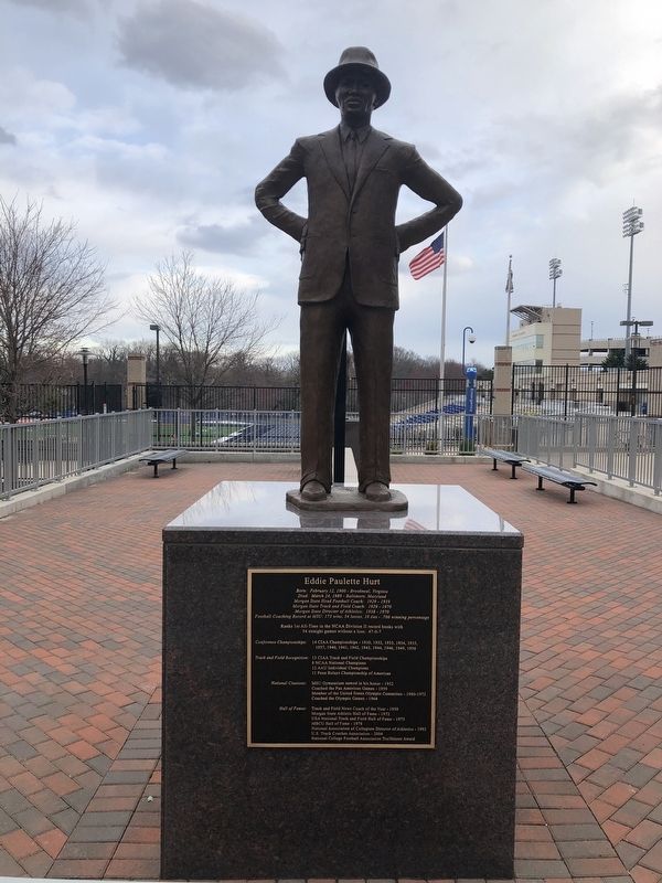
Born: February 12, 1900 - Brookneal, Virginia
Died: March 24, 1989 - Baltimore, Maryland
Morgan State Head Football Coach: 1929 - 1959
Morgan State Track and Field Coach: 1929 - 1970
Morgan State Director of Athletics: 1958 - 1970 . . . — — Map (db m145931) HM
Near Hillen Road (Maryland Route 41) 0.1 miles south of East Cold Spring Lane, on the right when traveling north.
Founded at Morgan State College
October 12, 1962
"We've come this far by faith"
The International Membership of Groove Phi Groove Social Fellowship, Inc.®
National Presidents
Lenwood W. Harris, Jr. 1969/1970-1971 . . . — — Map (db m145929) HM
Near Hillen Road (Maryland Route 41) just south of Morgan State Campus Road, on the right when traveling north.
Holmes Hall (1949)
The building was named in honor of Dr. Dwight Oliver Wendell Holmes, the sixth President of Morgan College (1937-48). Dr. Holmes successfully guided the destinies of the College during a critical period in our nation's history, . . . — — Map (db m145927) HM
Near Hillen Road (Maryland Route 41) 0.1 miles south of East Cold Spring Lane, on the right when traveling north.
Founded at
Morgan State College
(University)
on
September 19, 1963
Motto
"Building a Tradition
Not
Resting Upon One"
The
Founding
Principles
of
Iota Phi Theta
Fraternity, Inc.
Leadership
Scholarship . . . — — Map (db m145930) HM
On Perring Parkway (Maryland Route 41) at Hillenwood Road, on the right when traveling east on Perring Parkway.
Welcome to Morgan State University
For over 140 years, Morgan State University has been an important part of the higher education system in Baltimore City, the State of Maryland, and the nation. Throughout its history, Morgan has served the . . . — — Map (db m145933) HM
Near Perring Parkway (Maryland Route 41) at Hartsdale Road, on the right when traveling east.
Stevens graduated from Morgan State University in 1988 with a degree in telecommunications. But instead of pursuing a career in reporting on newsmakers she became one in a big way.
While at Morgan State University, Stevens was a world class . . . — — Map (db m145924) HM
Near Perring Parkway (Route 41) at Hartsdale Road, on the right when traveling east.
A 1973 graduate of Morgan State University, Rhoden worked as the school's assistant sports information director while still a student. After graduating, he joined Ebony magazine as an associate editor in 1974. Four years later Rhoden became a . . . — — Map (db m145925) HM
In the early 1950s, the 900 block of Tyson Street made national news for its dramatic transformation from a dilapidated street of falling down houses to a street framed by quaint pastel-colored homes. In 1948, City inspectors had condemned Tyson . . . — — Map (db m102864) HM
Across Howard Street, Johns Hopkins University opened in 1876 as America’s first research university. The University attracted and trained some of the best minds of the 19th century: philosophers Josiah Royce and Charles Sanders Pierce; physician . . . — — Map (db m102805) HM
The Eubie Blake National Jazz Institute and Cultural Center, founded in 1981 was a rich history which started over 25 years ago when the organization began as a Model Cities Arts Program. The estate of James Hubert Blake, better known as . . . — — Map (db m102810) HM
On West Monument Street at Park Avenue, on the left when traveling east on West Monument Street.
This site and these buildings were presented to the Maryland Historical Society as a memorial to my husband H. Irvine Keyser of Baltimore. Obit May 7, 1916. A member of the Society 1873 to 1916. — — Map (db m2527) HM
On West Mount Vernon Place, on the right when traveling east.
Built in 1850, Hackerman House, formerly the Thomas-Jencks-Gladding Mansion, was given to the City of Baltimore by Willard and Lillian Hackerman in 1984 and conveyed to the Walters Art Museum by the Honorable William Donald Schaefer in 1985. . . . — — Map (db m6019) HM
On West Monument Street at Park Avenue on West Monument Street.
The Maryland Historical Society (MdHS) is the state's oldest continuously operating cultural institution. Founded in 1844, it was first located in the Athenaeum at St. Paul and Saratoga Streets. In 1919 it moved to its current location on W. . . . — — Map (db m10249) HM
On West Franklin Street (U.S. 40) at North Charles Street, on the right when traveling west on West Franklin Street.
In 1817, when Baltimore Town boasted 60,000 inhabitants and Mount Vernon Place was still a forest, a group of leading citizens met in the home of Henry Payson "to form a religious society and build a church for Christians who are Unitarian and . . . — — Map (db m7168) HM
On West Madison Street at Cathedral Street, on the right when traveling west on West Madison Street.
The Morison is a pre-Civil War freestanding mansion constructed in 1852 as a private residence for Nathaniel Holmes Morison (1815-1890). In 1867, Morison became provost of the Peabody Institute. George Peabody, a Baltimore dry goods merchant . . . — — Map (db m183386) HM
On Monument Street at N. Charles Street, on the right when traveling east on Monument Street.
Established in 1857 by the philanthropist George Peabody, The Peabody Conservatory of Music was the first institution in America for the education of professional musicians. The list of those who have taught or studied here reads like a “Who’s . . . — — Map (db m2411) HM
On Mount Vernon Place, on the right when traveling east.
Philanthropist George Peabody founded the Institute in 1857 as a cultural center for the city's residents. In addition to establishing the first academy of music in America, the Institute originally comprised a public library, a lecture series, and . . . — — Map (db m7950) HM
On East Mount Vernon Place at N. Charles Street, on the right when traveling east on East Mount Vernon Place.
In 1857, George Peabody’s founding letter dedicated the Peabody Institute to the citizens of Baltimore in appreciation for their “kindness and hospitality.” The Massachusetts-born philanthropist eventually moved to London where he built . . . — — Map (db m2410) HM
Near Smith Avenue west of Greely Road, on the right when traveling west.
In 1853, the Reverend Elias Heiner and George Gelbach, Jr. purchased several hundred acres called "Edwards and Wills Valleys and Hills" in Mt. Washington to establish a female college and German Reformed church.
Reverend Heiner and architect . . . — — Map (db m212274) HM
The Woman’s College of Baltimore was founded in 1884, when Reverend John Franklin Goucher, pastor of the Methodist Episcopal Church, and his wife, Mary C. Fisher, offered land and $150,000 to establish a college for women.
The first class of . . . — — Map (db m102849) HM
On East Baltimore Street just west of North Belnord Avenue, on the right when traveling west.
See the world not as you want it to be, but as it is, and then fix it.
Dedicated to Ed Rutkowski, Visionary and Founder of Patterson Park Public Charter School in recognition of a lifetime of love and service for . . . — — Map (db m212977) HM
On Amity Street, 0.1 miles north of Fayatte Street, on the right when traveling north. Reported permanently removed.
“The little house in the lowly street with the lovely name.” This was how Edgar Allan Poe described 203 Amity Street, where he lived from 1832 to 1835 with his grandmother, aunt, and cousin Virginia, whom he married in 1836.
While living . . . — — Map (db m2506) HM
Near North Paca Street (Maryland Route 129) at George Street, on the left when traveling north.
Drawing of historic seminary chapel by Maximilian Godefroy, c. 1806
The historic chapel of St. Mary's Seminary & University (est. 1791) was built by the Sulpician Fathers and dedicated in 1808. It was designed by Maximilian Godefroy and is . . . — — Map (db m220047) HM
On North Paca Street (Route 129) just north of George Street, on the left when traveling north.
Existing Buildings
① St. Mary's Chapel - 1808
② Mother Seton House - 1808
③ Spiritual Center - 1898 (Former Convent of the Sisters of Divine Providence)
④ Visitors Center - 2009
Buildings . . . — — Map (db m220046) HM
Near North Paca Street (Maryland Route 129) north of George Street.
Here, at the One Mile Tavern, in 1791, the Fathers of St. Sulpice (Paris, France) founded St. Mary's, the first Roman Catholic Seminary in the United States. Maryland was then a center of Catholic activity, with Baltimore having been selected at . . . — — Map (db m7186) HM
On George Street, on the right when traveling west.
At this site, 610 George Street, under the leadership of foundress, Mother Mary Lange, four women took vows of consecrated chastity, evangelical poverty, and religious obedience. Thus began the Oblate Sisters of Providence, the first Congregation of . . . — — Map (db m5559) HM
Near West Hamburg Street, on the right when traveling west.
Solo Gibbs Park was created in 1979 when 1-395 was built. The 1869 Sachse Bird's Eye View Illustrated Map shows the once larger neighborhood where, since the late 1700s a free African American community lived, worked and worshipped along side . . . — — Map (db m6356) HM
Near Eutaw Street south of West Camden Street, on the right when traveling south.
For more than three decades, Len Johnston has served in the Orioles' player development department as a scout, coach, manager, camp coordinator and more. Joined the organization in 1976 as manager at Class A Miami, having already played, . . . — — Map (db m247413) HM
On South Greene Street (Maryland Route 295) near West Lombard Street, on the right when traveling south.
On this site in 1823 the faculty of the University of Maryland College of Medicine erected the Baltimore Infirmary, the first teaching hospital associated with a degree-granting school of medicine and the original residency program in medical . . . — — Map (db m10006) HM
On Lombard Street at Greene Street, on the right when traveling west on Lombard Street.
Davidge Hall, constructed in 1812, is named for the first dean of the University of Maryland School of Medicine, Dr. John B. Davidge. Noted for its unique classical appearance, it is the oldest building in the country used continuously for medical . . . — — Map (db m15057) HM
On West Baltimore Street, on the left when traveling east.
Baltimore College of Dental Surgery, first dental college in the world chartered by the General Assembly of Maryland March 6, 1840. Founders were Horace H. Hayden, M.D., D.D.S. and Chap A. Harris M.D., D.D.S. The Assembly stipulated by Act of . . . — — Map (db m2530) HM
1737-1809 Elizabeth McDonogh 1746-1808 Parents of John McDonogh Founder McDonogh School for Boys Restored by The McDonogh Alumni Association 1949 — — Map (db m6631) HM
Baltimoreans associated the name McDonogh with a well-known private school founded in 1873. Buried here are the parents of the school's founder, Irish natives John (1734-1809) and Elizabeth McDonogh (1747-1808).
John McDonogh, a brickmaker, . . . — — Map (db m6633) HM
On Pennsylvania Avenue at McMechen Street on Pennsylvania Avenue.
Although the Pennsylvania Avenue of the 1920s was Baltimore’s premier shopping district for African Americans, many of the businesses that served them were owned by whites who refused to hire African Americans from the neighborhood.
In 1933, . . . — — Map (db m168767) HM
PS 103 is listed in the National Register of Historic Places as part of the Old West Baltimore National Register Historic District. It is one of the attractions along the Pennsylvania Avenue Heritage Trail scheduled to open in 2008 by the Baltimore . . . — — Map (db m101955) HM
On Division Street, on the left when traveling north.
"Why, of all the multitudinous groups of people in this country, do you have to single out Negroes and give them separate treatment?" Thurgood Marshall reproached the Supreme Court with this and other questions in the landmark civil rights case . . . — — Map (db m6636) HM
On Bloomsbury Avenue south of Bloomingdale Avenue, on the left when traveling north.
On September 10, 1935, Black students Lucille Scott and Margaret Williams were denied admittance to Catonsville High School. NAACP attorney Thurgood Marshall filed suit. Although they lost the case, Maryland's Court of Appeals . . . — — Map (db m128246) HM
On Academic Row, on the left when traveling north.
Named in honor of George and Betsy Sherman, in recognition of their sustained generosity and deep commitment to making a difference through education. Their philanthropy in the Baltimore community has helped serve at-risk children and families, and . . . — — Map (db m145235) HM
On Hilltop Circle, on the right when traveling north.
Named in honor of Baltimore's legendary civic leader and his wife, Sondheim Hall and the Janet and Walter Sondheim Public Affairs Scholars Program affirm UMBC's connections to Baltimore and the university's mission to integrate research, teaching . . . — — Map (db m145236) HM
Near Academic Row, on the right when traveling north.
Named in honor of Robert and Jane Meyerhoff, whose commitment to nurturing the potential of others launched the Meyerhoff Scholarship program at UMBC and established the University as a leader in achieving both excellence and diversity. Their . . . — — Map (db m145233) HM
The furnace owners constructed a town composed of tenant and boarding houses, forge Stock house, spring houses, and company store (now the Oregon Grille Restaurant 2007) to support furnace operations and to house 200 residents.
Tenant . . . — — Map (db m219134) HM
This tablet placed here by the citizens of Dundalk in greatful appreciation to the Bethlehem Steel Company for making this building available as a Community Public Library — — Map (db m101205) HM
On Freeland Road north of Railroad Avenue, on the left when traveling north.
Freeland, Maryland is the last of the small rural villages in Northern Baltimore County that flourished along the route of the Northern Central Railroad during the late 1800's and early 1900's. It is located just 1-1/2 miles south of the . . . — — Map (db m131332) HM
On Cradock Lane, 0.5 miles Reisterstown Road (Route 140), on the left when traveling north.
Named for free school of Trentham, Staffordshire, England, where Reverend Thomas Craddock had taught. When he married High Sheriff John Risteau’s daughter, this estate was her dowry. They built a house in 1746 and in 1747 he opened a boy’s boarding . . . — — Map (db m2069) HM
On Butler Road (Maryland Route 128) at Waugh Avenue, on the left on Butler Road.
Founded in 1868 for the purpose of promoting the cause of morality and religion by holding camp meetings under the auspices of the Methodist Episcopal Church.
Incorporated 1871 and reincorporated 1884 under present name of the Emory Grove . . . — — Map (db m2066) HM
On Hilltop Circle, 0.1 miles east of Commons Drive, on the right when traveling east.
"Baltimore Farm Where They Raise — Good, Honest Citizens",
"Just outside the pretty little village of Arbutus, about seven miles from Baltimore, there is a farm whose principle product for 60 years has been men. It is a beautiful farm, too, . . . — — Map (db m145239) HM
On Falls Road (Maryland Route 25) near Entrance to St. Paul’s School, on the left when traveling north.
Built by Charles Carroll of Carrollton for his daughter, Mary Caton. Site of the first Maryland Hunt Cup and Grand National Races.
Owned successively by John Cockey, Charles Carroll, George Brown, Captain Isaac Emerson and Saint Paul's School . . . — — Map (db m2273) HM
On Front Street at Morris Street, on the right when traveling south on Front Street.
Lutherville, named for Martin Luther, was founded, 1852, by Dr. John G. Morris, a Lutheran clergyman, as the location of Lutherville Female Seminary. The planned village, centering around the Lutheran Church and Seminary, was surveyed into 118 lots . . . — — Map (db m2298) HM
On Strawberry Point Road, 0.8 miles east of Wilson Point Road, on the right when traveling north.
⬥ Last served with VC-8, Roosevelt Roads NAS, Puerto Rico as an "aggressor" aircraft in support of "Top Gun" training.
⬥ The A-4 series aircraft served in Vietnam. This TA-4J model is the advanced training version of the basic . . . — — Map (db m189857) HM
On Strawberry Point Road, 0.8 miles east of Wilson Point Road, on the right when traveling north.
• Early USAF Jet Trainer
• Built by the Lockheed Co.
• Donated by the U.S. Army Aug. 1994
• Last Flown by the New York Air National Guard
• Characteristics:
On Strawberry Point Road, 0.8 miles east of Wilson Point Road, on the right when traveling north.
★ Training platform for Navy/Marine Corps pilots
★ Built by Raytheon Aircraft Company (Formerly Beech Aircraft)
★ Date deployed: Operational, 1977
★ Donated by: U.S. Navy, June 2013
★ Speed: 322 MPH
★ . . . — — Map (db m189819) HM
On Orems Road at Glider Drive, on the right when traveling west on Orems Road.
Located near the corner of Orems Road and Glider Drive; adjacent to the West side of the Orems Methodist Church Cemetery. Built for the education of local students from Stemmers Run and Middle River. Originally a one-room log school house. . . . — — Map (db m141242) HM
On Oella Avenue just north of Frederick Road (Maryland Route 144), on the left when traveling south.
The Trolley Trail runs on the track bed built for the #9 Route that connected Ellicott City to Catonsville and Baltimore. Many used the line to get to work or shop in Baltimore. "I could tell by the color whether to board the front or the . . . — — Map (db m144720) HM
On Reisterstown Road at Academy Lane on Reisterstown Road.
Oldest Episcopal Boarding School for girls in the United States. Mrs. Ann Van Bibber Neilson gave three acres of land at this location and $10,000 to found and academy for girls. The academy became the Diocesan School for the Episcopal Diocese of . . . — — Map (db m65292) HM
On Cockey’s Mill Road at Reisterstown Road (Route 140), on the left on Cockey’s Mill Road.
Franklin Academy founded January 10, 1820 by an Act of the General Assembly of Maryland. On January 25, 1849 became a public school. Was Reisterstown High School from 1874–1896. Became Franklin High School in 1897. — — Map (db m2062) HM
On Sparks Road, 0.6 miles east of York Road (Maryland Route 45), on the right when traveling east.
In 1835, the Baltimore and Susquehanna Railroad constructed a track through Baltimore County which included a siding and switch near a large tract of land owned by the Sparks family. Railroad officials gave the name Sparks to the switch and soon . . . — — Map (db m95687) HM
Near Goucher Road, 0.6 miles Dulaney Valley Road (Maryland Route 146), on the left when traveling east.
This springhouse was built in the eighteenth century and was part of the Epsom estate. It is the oldest known building on Goucher's campus. The first restoration was completed in 1979 in memory of Walter M. Morris, professor of religion from . . . — — Map (db m144055) HM
On Goucher Road just east of Dulaney Valley Road (Maryland Route 146), on the left when traveling west.
Honoring
William Westley Guth
Fourth President of Goucher College
1913 - 1929
Through his foresight this
land was purchased in 1921
— — Map (db m144058) HM
Near Goucher Road, 0.6 miles east of Dulaney Valley Road (Maryland Route 146), in the median.
Fern Karesh Hurst, Class of 1968, came to Goucher College from Charleston, South Carolina. She graduated with a degree in political science and received a master's degree in city planning from the University of Pennsylvania. An advocate for Goucher . . . — — Map (db m144052) HM
Near University Avenue, 0.1 miles south of Towsontown Boulevard West, on the right when traveling south.
The Towson University Student Government Association and the University's Department of Veterans Services recognize the service of its students in the United States Armed Forces and remember those who have made the ultimate sacrifice. — — Map (db m174860) WM
On York Rd at York Rd & Chesapeake Ave, on the right when traveling south on York Rd.
Founded in 1936 by the Woman's Club of Towson, the Towson Library began as a volunteer organization operating out of the home of the first librarian, Mary Osborne Odell. Under her direction for the next 16 years, it grew rapidly. in 1948 the . . . — — Map (db m224805) HM
During the War of 1812, an armory was built near the intersection of Dulaney Valley and Joppa Roads. It was soon abandoned. In the 1830's, Henry Chew built a house on this site and decorated the lawn with a cannon from the deserted armory. The house . . . — — Map (db m57136) HM
Carver High School was one of the three schools built simultaneously in 1939 by Baltimore County to educate colored students in grades 8 through 12. Previously, those students were sent to Baltimore city for high school. The Carver School replaced a . . . — — Map (db m226653) HM
Faculty & students campaigned for women’s suffrage, hosted suffrage seekers & marched in Washington DC 1913. Students picketed White House 1917. — — Map (db m145894) HM
On Broomes Island Road (Maryland Route 264) 0.4 miles south of Solomons Island Road (Maryland Route 2 / 4), on the left when traveling south.
Port Republic School No. 7, built about 1870 and closed in 1932. One teacher usually taught seven grades. Children walked to school from as far as three miles away. In the 59 similar schools throughout Calvert County, enrollment averaged about 30. . . . — — Map (db m3442) HM
Near Broomes Island Road (Maryland Route 264) 0.4 miles south of Solomons Island Road (Maryland Route 2), on the left when traveling south.
Port Republic School #7 was built on this site around 1870 and remained in continuous use until it was closed in 1932. This school is from a time when free public education for all was a new concept in post-Civil War America.
This schoolhouse . . . — — Map (db m66097) HM
On Dares Beach Road (Maryland Route 402) 1.2 miles east of Maryland 2/4, on the left when traveling east.
Oldest standing one-room schoolhouse for
African American students in Calvert County.
Offered education for grades 1-7 in the
Wallville community. Illustrates the
segregated educational facilities of the late
19th and early 20th centuries. . . . — — Map (db m54367) HM
On Duke Street, 0.1 miles east of Solomons Island Road (Maryland Route 2/4), on the left when traveling east.
The west wing of this library was built in 1903 on Main Street as the County’s first bank. In 1913, it was replaced, moved and became the County’s first library; 1916 County’s first Boy Scoot Troop met there; 1921 it was County’s first high school; . . . — — Map (db m3454) HM
On Dares Beach Road (Maryland Route 402) east of Solomons Island Road (Maryland Route 2), on the right when traveling east.
The first public high school for African Americans in Calvert County was opened in 1938 and served until desegregation in 1966. Named for William Sampson Brooks (1865–1934). Born in Calvert County, Rev. Brooks was an advocate of education, . . . — — Map (db m29522) HM
On Charles Street just east of Williams Street, on the right when traveling east.
Built in 1924 by Clarence Davis as a general store operated by Gus, Sam and Hyman Becker; later converted to a laundromat. Acquired by CBL in 2000. — — Map (db m138618) HM
Near Solomons Island Road South (Maryland Route 2) just south of Thomas Johnson Road, on the left when traveling north.
Stats
Like all Chesapeake skipjacks, the Dee of St. Mary's has a shallow draft to negotiate the waters along the shorelines and a wide bottom for stability. She is constructed mostly of white oak and spruce pine.
On Farren Avenue, 0.1 miles south of Charles Street (Maryland Route 2), on the right when traveling south.
Founded by R.V. Truitt, 1925. Sponsored by Maryland Conservation Department since 1931, in cooperation with Carnegie Institution, Johns Hopkins and Maryland universities, Goucher, St. John's, Washington, and Western Maryland colleges "to afford a . . . — — Map (db m3456) HM
On Williams Street just south of Charles Street, on the right when traveling south.
Built in 1980 and dedicated in 1992 to honor Dr. Romeo Mansueti (1923-1964), a former CBL fishery scientist, naturalist, and biological illustrator.
This building is home to CBL's administrative offices. Housed within are the . . . — — Map (db m138619) HM
On Charles Street west of Farren Avenue, on the left when traveling west.
Built in 1954. After acquisition by CBL in 1991, it was named after the Solomons Episcopal Rectory and Parish House formerly occupying the site part of which had been used by CBL founder Dr. R. V. Truitt as a research laboratory. . . . — — Map (db m138620) HM
On Charles Street just east of Williams Street, on the left when traveling east.
Built in the early 1890s as a general store and ice cream parlor run by Thomas and Bertie Saunders. In the 1930s it became a gathering place for local watermen. Acquired by CBL in 1994. — — Map (db m138617) HM
Near Solomons Island Road South (Maryland Route 2) south of Thomas Johnson Road, on the left when traveling south.
This flagpole is reputedly made from the mast of the sailing brogan James Aubrey. The mast was removed when the vessel was converted to power and used to transport students to the Solomons School from 1925 to 1935. The Solomons School is now . . . — — Map (db m138611) HM
On St. Leonard Road (Maryland Route 765) 0.1 miles south of Calvert Beach Road, on the right when traveling south.
The Honorable Thomas Parran (1860-1955)
Thomas Parran, the St. Leonard citizen who played a key role in the construction of the St. Leonard Polling House, was born on February 12, 1860, on the Chestnut Hill Farm (see map) in St. Leonard . . . — — Map (db m181801) HM
On Solomons Island Road (Maryland Route 2) at Pushaw Station Road, on the right when traveling north on Solomons Island Road.
During the period of racially segregated education, elementary school teacher Brown enlisted the N.A.A.C.P. and attorney Thurgood Marshall to challenge the inequity of separate salary scales for public school teachers based on race. Her case was . . . — — Map (db m5573) HM
On South 2nd Street south of Franklin Street (Maryland Route 404), on the left when traveling north.
This property has been
placed on the
National Register
of Historic Places
by the United States
Department of the Interior
[Additional plaque nearby:]
This 1883 schoolhouse and the colonial garden was owned by the Woman's . . . — — Map (db m137766) HM
On Maryland Route 404 at Maryland Route 328, on the right when traveling west on State Route 404.
Neck or Tuckahoe Neck Meeting House was built in 1802 by members of the Society of Friends who had been Nicholites, a sect that originated in Caroline County. The building was used as a house of worship and as a Friends School until 1897. The . . . — — Map (db m5075) HM
On West Belle Road at Cow Barn Road, on the left when traveling west on West Belle Road.
In 1896, Ridgely emerged from a village into the dignity of a town. It was incorporated as such with the following first town commissioners: Mr. Sylvester Smith; Mr. T.W. Jones, Dr. F.P. Herr; Mr. T.L. Day; and Mr. J.T. Saulsbury.
The entire . . . — — Map (db m205470) HM
On Keysville Bruceville Road when traveling south.
Francis Scott Key
Author of
The Star Spangled Banner
Gave This Ground
For Church And
School Purposes
In 1823
Erected by
The P.O.S. of A. Of Maryland
June 10, 1916 — — Map (db m80086) HM
On Henryton Road at Henryton Center Road a.k.a.Henryton Hospital Road on Henryton Road.
In 1925, two years after the Maryland Tuberculosis Sanatorium opened in Henryton, a training school for nurses was established for black students in order to help manage the increasing patient population. The program was revised in 1945 to meet . . . — — Map (db m96080) HM
On South Main Street (Maryland Route 808) south of Center Street, on the right when traveling south.
This building was originally the home of the Mt. Airy Savings Bank, which was taken over by the Commercial Bank of Maryland from Frederick in 1916. Since then, it has been home of a number of other businesses and institutions including: . . . — — Map (db m199368) HM
On South Main Street (Maryland Route 808) just south of Center Street, on the left when traveling north.
Mount Airy was first settled along what is now Ridgeville Boulevard. With the construction of the Old National Pike (Route 40) in the 1730s, Ridgeville became a rest stop and overnight lodging for travelers on the road. In 1831 the Baltimore and . . . — — Map (db m199372) HM
On South Main Street (Maryland Route 808), on the left when traveling south on South Main Street.
The Flat Iron Building, also called the Pryor Building was built by Mr. William E.T. Smith in March and April of 1903. The building was constructed to replace the frame building used as a harness shop, which was destroyed in the catastrophic . . . — — Map (db m199413) HM
Dedicated to the pupils and teachers who learned within these four walls. 1904 - 1939 Restoration dedicated on September 15, 2006 With appreciation to the organizations and individuals whose generous donations of time, expertise and revenues led . . . — — Map (db m50194) HM
On Main Street, 0.1 miles south of Union Bridge Road, on the right when traveling south.
Elmer A. Wolfe High School was built just east of this site in 1931. The building was demolished in 1996 and replaced by the present Elmer A. Wolfe Elementary School. — — Map (db m91315) HM
On Hersh Avenue at West Main Street, on the right when traveling north on Hersh Avenue.
Carroll Hall - 1873
President's House - 1889
Levine Hall - 1891
Baker Chapel - 1895
Alumni Hall - 1896
Ward Memorial Arch - 1898
Designated Historical Places
on the
National Register
U.S. Department of the . . . — — Map (db m147270) HM
Near South Center Street north of Gist Road, on the right when traveling south.
Landon C. Burns was born in 1897 in Virginia. He graduated from the University of Maryland with a B.S. Degree in Agriculture Education and later earned an M.S. Degree in Rural Sociology. The man who was often called "Mr. Carroll County" was . . . — — Map (db m114412) HM
622 entries matched your criteria. Entries 201 through 300 are listed above. ⊲ Previous 100 — Next 100 ⊳