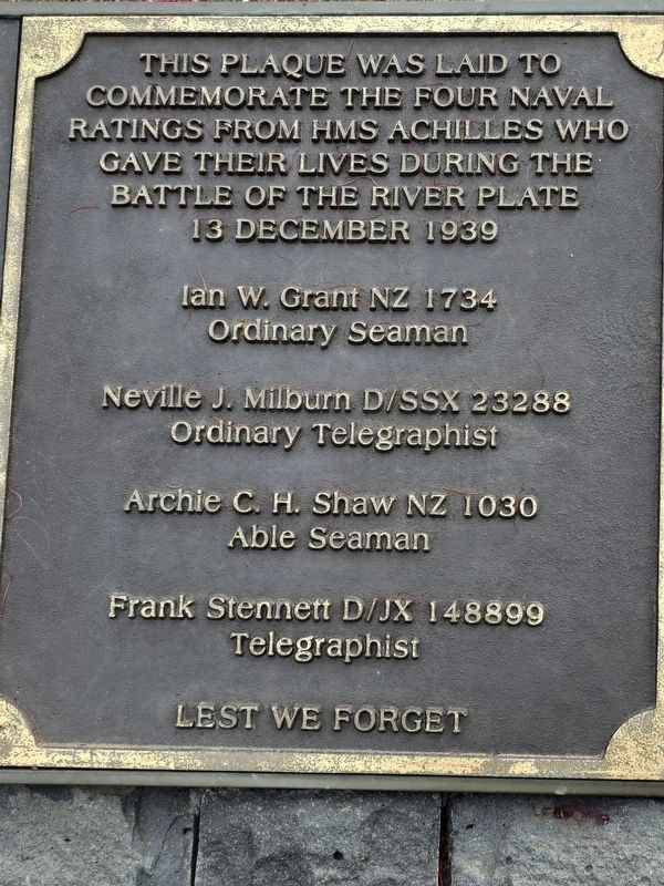
This reserve is dedicated to commemorate the gallant performance of H.M.S. Achilles and the bravery of her captain, officers and ship's company in the victorious naval battle fought in the South Atlantic off the River Plate on December 13th, 1939. . . . — — Map (db m291282) HM
A Stripped Classical British design, the building is a rare example of the commercial architecture of Basil Hooper who was better known for his Arts and Crafts houses. — — Map (db m222509) HM
Built - 1912 Auckland Harbour Board
Restored - 1988 Challenge Properties Ltd.
Officially opened 5 November 1988 by His Excellency the Governor-General
the Most Reverend Sir Paul Reeves, GGMG, GGVO — — Map (db m222467) HM
The General Building is one of the best preserved Chicago-style high rises in Auckland and is an excellent example of early 'modern' American architecture in New Zealand. — — Map (db m222901) HM
Lord Freyberg V.C., G.C.M.G., K.C.B., K.B.E., D.S.O.
1889 – 1963
Commander of the Second New Zealand Division 1939 – 1945
Governor-General of New Zealand 1946 – 1952
This memorial has been donated by returned servicemen to the citizens of . . . — — Map (db m223831) HM
In 1860 a brick courthouse was built on the corner of High and Chancery Streets. It was used as Auckland City Council offices from 1881-1887 and later a dental hospital. Adjacent to the court was a brick police station built in 1864 and used until . . . — — Map (db m222525) HM
Erected by the members of the N.Z. Battery R.A. In memory of their comrades Lieutenant Geo. Leece, Corporal Herbert A. Edwards, Bombardier John Mays, Driver John Beck, Gunners Joseph Brown, Frederick Forbes, Arthur W. Kendall, and Driver Thomas . . . — — Map (db m222474) WM
This elegant 'stripped classical' building, with a Portland stone facing, was built between 1926 and 1927 for the Dilworth Trust to provide income for philanthropic work. It was reputedly the secret control headquarters for the Battle of Guadalcanal . . . — — Map (db m222482) HM
New Zealands most famous aviatrix
The first person to fly solo from England to New Zealand. She left England on October 5th and landed here in Mangere 11 days later on October 16th 1936.
"I was destined to be a wanderer. I . . . — — Map (db m289655) HM
Nau mai, haere mai ki Maungawhau, ko Maungawhau tetahi o nga Tüpuna Maunga o Tamaki Makaurau
A warm welcome to Maungawhau, an ancestral mountain of Auckland
Maungawhau Pa
Maungawhau was historically one of . . . — — Map (db m291276) HM
Maungawhau is a wähi tapu, a sacred place of great historic and spiritual
significance to Nga Mana Whenua o Tamaki Makaurau (Maori tribes of
Auckland). From around 1200AD Maungawhau was one of the largest pa
(fortified settlements) in the . . . — — Map (db m292715) HM
The sailing vessel most identified with Auckland was the scow, a flat bottomed vessel with a lifting centerboard enabling easy beaching. Based on a North American Great Lakes design, they carried every sort of cargo, but mainly logs, cattle, sand . . . — — Map (db m222462) HM
Side 1: To commemorate the valor of King's Sergt Fred W. Wylie of Galatea Rotorua Fourth N.Z. Contingent.
Side 2: Erected by the public and rifle volunteers of Rotorua
Side 3: He recaptured unaided a 15-pr gun, taking . . . — — Map (db m296248) WM
This historic area was gifted by the original Māori owners of the land, Ngāti Whakaue, in 1880 ‘hei ōranga mo ngā iwi katoa o te ao - for the benefit of the people of the world’.
The carefully laid out gardens you are . . . — — Map (db m289856) HM
The tōtara carvings that greet you as you enter the Government Gardens were presented by the people of Ngati Whakaue to commemorate their original gift of this land in 1880 hei oranga mo nga iwi katoa o te ao for the benefit of the people of . . . — — Map (db m296260) HM
The wooden arches that grace the entrance to the Government
Gardens once spanned the intersection of Fenton and Hinemoa
Streets. Designed to represent the royal crown, they were erected
in 1901 to honour the visit of the Duke and Duchess of . . . — — Map (db m291701) HM
Built in 1907, the original pagoda-roofed tennis pavilion was
sited near the Malfroy Geysers. The pavilion was moved to its
present site during the 1920s, and extended over time. A terracotta
roof was added during the 1950s, and replaced in . . . — — Map (db m291704) HM
Assisted by the Rt Rev F A Bennett L.th bishop of Aotearoa commemorates the noble spirit and generosity of the chiefs and members of Ngāti Whakaue Tribe of Ohinemutu who in 1880 in meetings assembled laid the . . . — — Map (db m296253) HM
This monument commemorates Fred Wylie, a young soldier from
Galatea who fought in the Boer War with the Fourth New Zealand
Contingent. Son of the first store keeper in Rotorua, Joseph
Wylie, and a member of a unit known as the 'Rough Riders,' . . . — — Map (db m289909) HM
When rheumatism-wracked Father Mahoney soaked in his
hand-excavated pool in 1878 he would never have dreamed
his miraculous cure would put Rotorua on the map.
Priest water was touted as.an effective cure for a range of
complaints . . . — — Map (db m291863) HM
This geothermal reserve was given its widely recognised English name upon the visit of the famous Irish playwright George Bernard Shaw in the early 1900's. On this visit he determined that this area must be the gateway to Hell in which his . . . — — Map (db m296256) HM
Named Wariaod in honour of an illustrious ancestor, this building was erected by the Tuhourangi tribes, to mark in grateful recognition The close of the first hundred years Of British trusteeship and protection. Guaranteed to the Maori race by . . . — — Map (db m290613) HM
The word känapanapa means gleaming and glistening, reflecting the beautiful green colour of these waters. This sacred lake was traditionally used to prepare tūpāpaku (deceased individuals) for burial, as the waters . . . — — Map (db m295654) HM
He mea whakatu kê tenei whare karakia i Tarawera, he maunga, ahua 23km ki te uru o Whakarewarewa. I te 10 o Hune i te tau 1886, ka hú a Tarawera, i whakangaromia nga papakainga, me nga ripa takawai rongonui, ara ko Otükapuarangi me Te . . . — — Map (db m296323) HM
IPENZ recognises this engineering work as an
important part of N.Z.'s engineering heritage. Erected to supply the railway workshops, the water tower is one of the world's first structures in reinforced concrete.
Owner: The NZ Railways . . . — — Map (db m290101) HM
A violent and destructive earthquake shook greater Christchurch on 22 February 2011. The lives of 185 people were lost, and many were seriously injured. This was one of thousands of earthquakes experienced in the region, starting on 4 September . . . — — Map (db m291656) HM
The Arthur's Pass Chapel, dedicated in 1956, was designed by Paul Pascoe, a notable Christchurch architect, whose twin brother John was a famous mountaineer. The building's simple form recalls a mountaineer's tent, a Maori meeting house and a . . . — — Map (db m291999) HM
Steam locomotives hauled goods trains between Christchurch and Arthur's Pass until 1968 when diesel locomotives replaced them. The steam locomotives had to
be turned at Arthur's Pass for the return journey because they could not haul trains in . . . — — Map (db m292007) HM
This tower was erected to house the clock and chimes that were removed from the post office building in 1943 as an earthquake precaution. The funds were raised by public subscription from Taihape and district.
All materials and labour used in the . . . — — Map (db m223240) HM
Te ha o taku maunga, ko taku manawa
The breath of my mountain is my heart.
This reflects the spiritual nature of the Koha Tapu of Te Heuheu Tukino IV when he gifted the peak of Tongariro, Ngauruhoe and Ruapehu in 1887. . . . — — Map (db m289977) HM
Built of local bluestone and Oamaru stone, this building was designed by W.B. Armson and it was erected in 1883 by James Gore, who was mayor of Dunedin at the time. — — Map (db m291331) HM
This cross was given to the city by the Christian churches of Dunedin to mark the birth of the Christian faith 2000 years ago to remind future generations of their Christian heritage, and to recall the arrival here of the first Christian settlers. — — Map (db m291311) HM
Dunedin's period of prosperity
began with the discovery of gold
in Gabriel's Gully in 1861 and
led to the construction of many
beautiful large buildings that now
form the backbone of the city's heritage fabric.
Much of the first generation . . . — — Map (db m291318) HM
Erected by the People of Otago, in the year 1863, to the Memory of Captain William Cargill, the founder of this settlement and the first Superintendent of the Province. He arrived with the first party of Settlers on the 23rd day of March, 1848, . . . — — Map (db m291319) HM
Dunedin's first permanent Court House and Prison
were built on a narrow shelf of reclaimed land at the
foot of Bell Hill in 1859.
At that time the harbour ran up to the base of the
Jail building.
The Court House and Prison were part of . . . — — Map (db m291313) HM
This area became known as ‘The Exchange’ due to the presence of a
landmark Victorian building housing the Dunedin Stock Exchange. Once
the hub of the city, the Mason and Wales designed Exchange building was
originally intended as a post office . . . — — Map (db m290795) HM
THIS STONE JAIL is the only surviving part of the
barracks and prison buildings that occupied this flat
area cut out of the rock in the 1880's.
At that time the Russians had begun to build their first naval
base at Vladivostock for a . . . — — Map (db m291335) HM
A branch of the Bank of New Zealand was first
opened in Arrowtown on 1st October 1867, Mr. H. H. Holmden
being the first manager. The building on this site in which the bank first conducted its business was replaced
by the present stone building, . . . — — Map (db m290534) HM
Physical and emotional challenges extended beyond the search for gold. After Guangdong's near tropical climate, the newcomers would have been shocked by by Otago's brutally cold winters and made anxious by local hostility towards them.
A . . . — — Map (db m184767) HM
When asked to join the Paterson family on their voyage to a life in New Zealand, Bessie's sister Louise (wary of the sailing conditions)
demanded she be allowed space for cured meats, preserves, two cows and a goat. The cows would provide the . . . — — Map (db m290530) HM
Above the Woolshed was the storage loft for hay. The ground here outside the opening above had been built up to form a solid ramp allowing carts to back up to the stables and load the hay directly into the hayloft. Still a great workout for whoever . . . — — Map (db m290526) HM
In 1918 Australia was in the throes of two
equally problematic bans - alcohol consumption
and manure exporting. Facing a crippling
manure shortage, traders halted sales to their
kiwi neighbours. So, William began stockpiling
his own. New . . . — — Map (db m290474) HM
Planted 1867 - The First of the Avenue
The two-year-old Mary Cotter, after whom this nearby sycamore tree is named, lived with her early gold-mining family in a house on this corner section of the reserve known from the 1860s until the 1930s . . . — — Map (db m290532) HM
From the late 1860s to the 1880s this was one of many camps and settlements established by Chinese gold seekers in Otago-Southland. By the turn of the century, however, most had been abandoned, their simple dwellings left to decay. Today the . . . — — Map (db m184758) HM
Moa are thought to have become extinct 200 years ago.
For millions of years they were the largest living animal in
New Zealand and the tallest bird in the world.
There were 11 species of which the one depicted here, Dinornis
Giganteus, was . . . — — Map (db m290423) HM
This pass, the Crown Range Summit, at 1076 metres above sea level, is the highest sealed road in New Zealand.
In February 1860, W.G. Rees and P. Von Tunzelman were the first Europeans to cross the pass, searching for sheep pasture and . . . — — Map (db m290535) HM
In June 1886 the first Police House, a lock-up and
stable were built on this site (photo right, taken
c.1890). Larrikinisim and drunkenness were the most
common police issues reported in 1893.
This stone building was the stable and likely . . . — — Map (db m290349) HM
South West New Zealand is one of the great wilderness areas of the Southern Hemisphere. It is an area where snow-capped mountains, rivers of ice, deep lakes, unbroken forests and tussock grasslands produce a landscape of exceptional beauty. In this . . . — — Map (db m185281) HM
Dumont d'Urville in the corvette
"Astrolabe" anchored in this
roadstead 16 to 22 January 1827 Here he determined latitude and longitude and named landmarks — — Map (db m249701) HM
IPENZ recognises that this steam powered floating crane is an important part of New Zealand’s engineering heritage.
This floating crane was built in Scotland in 1926 and sailed under its own power with crane erected, to New Zealand. This is . . . — — Map (db m223354) HM
Tōna Hōnore a Richard John Seddon
Ko Richard Seddon tētahi o ngā pirimia o Aotearoa i mōhio whānuitia.
He tangata nunui, he aumangea, he awe nui tōna i te ao tōrangapū.
No . . . — — Map (db m291862) HM
During the busy shipping era of the gold rushes, Cape Foulwind had no lighthouse. It was much later that a timber lighthouse was built. First lit in 1876, its beacon guided vessels to the Buller for half a century before being replaced by the . . . — — Map (db m184821) HM
For hundreds of years Karamea Estuary has been a home, a source of food and materials, and a link to the outside world. Early Māori used the estuary as a summer camp along the pounamu (greenstone) trading route from AD 1500. Large shell middens . . . — — Map (db m184838) HM
In 1864 Gold was discovered here in the Grey District,
Westland. The goldrush brought 29,000 diggers by ship
and across the mountain passes to Te Wai Pounamu
(the place of Greenstone).
Many never made it.
Floods and shipwrecks were . . . — — Map (db m290235) HM
This monument was unveiled by Mayor Tony Kokshoorn, supported by the Chair, Francois Tumahai of Te Runanga o Ngati Waewae & Ngati Mahaki on 21st May 2010, to mark the 150th anniversary of the purchase of Westland.
Purchase of Westland: . . . — — Map (db m290236) HM
The timber-framed, weatherboard-clad building now known as Donovan's Store was built during the time of the first West Coast gold rush in the 1860s. Trading initially as the Club Hotel, it survives as the oldest building of its kind on the West . . . — — Map (db m184814) HM
Gone but not forgotten. Don't let rowi become just a memory.
The statue in front of you is a moa - these giant birds once
roamed New Zealand. Moa were easy to hunt and excellent to eat.
Unfortunately, this meant that they were . . . — — Map (db m290330) HM
1878
18,000 years ago the Franz Josef Glacier / Ka Roimata o Hine Hukatere extended 10km past the current coastline — meaning the spot where you are now standing was once covered by ice hundreds of metres thick! Evidence of this is dotted . . . — — Map (db m185280) HM
This is a powerful place where land meets sea, where nature's forces collide creating landforms shaped by ice, river and ocean. The Tasman's heaving surf continues to mould beaches and dunes, constantly wrestling with river mouths and tossing their . . . — — Map (db m185655) HM