On State Highway 78, 0.4 miles south of County Route Y, on the left when traveling south.
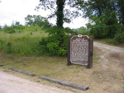
On July 21, 1832, during a persistent rainstorm, the 65-year old Sac Indian leader, Black Hawk, led 60 of his Sac and Fox and Kickapoo warriors in a holding action against 700 United States militia at this location. The conflict, known as the . . . — — Map (db m32301) HM
The origin of the East Park neighborhood begins in 1879, when local residents formed the Stoughton Fair Association. They built a racetrack, a grandstand and held the first Stoughton Fair here that same year. This venture was short-lived. By 1890, . . . — — Map (db m185570) HM
On East Main Street (U.S. 51) west of South 5th Street, on the right when traveling east.
This district is a collection of Victorian and early 20th-century commercial buildings, largely built between 1860 and 1910. Once southern Dane County's mercantile center, the district provided extensive retail and professional services. Extending . . . — — Map (db m22708) HM
On Williams Drive, 0.3 miles north of River Drive, on the left when traveling north.
Wisconsin's most famous political leader and greatest statesman. Born on a farm in Primrose Township, Dane County, he was the first native son and first University of Wisconsin graduate to become Wisconsin Governor. He rose from Dane County . . . — — Map (db m207173) HM
On East Main Street (State Highway 19) at Vine Street on East Main Street.
This world-renowned artist was born in the Town of Sun Prairie on November 15, 1887. She was the second of seven children born to Francis and Ida O'Keeffe. Georgia grew up on the family farm south of the city of Sun Prairie. As a child, she received . . . — — Map (db m22692) HM
On Campus Lane, 0.1 miles west of Edgerton Road (Wisconsin Highway 106), on the left when traveling west.
Albion Academy and Normal Institute, chartered in 1853 and opened in 1854, on land donated by Jesse Saunders, was founded and operated by Northwestern Seventh Day Baptist Association until 1894; by Peter Hendrickson, former Beloit College professor, . . . — — Map (db m40436) HM
On Front Street (Business U.S. 151) west of North Center Street (State Highway 33), on the right when traveling west.
Frederick Douglass was a former runaway slave who was a leading orator and author of the abolitionist movement. He is regarded as one of the most influential Americans of the nineteenth century. On October 20, 1856, Douglass came to Beaver . . . — — Map (db m22986) HM
On Spring Street (State Highway 33) 0.1 miles south of Cordelia Street, on the right when traveling south.
This was the hometown of famed jazz trumpeter and band leader, Bunny Berigan. As a child he played in the Fox Lake Juvenile Band directed by his grandfather, John C. Schlitzberg.
In his early teens, he began his professional career with the . . . — — Map (db m22989) HM
On Lincoln Drive west of South Mill Street, on the left when traveling west.
Tall and lanky, Wisconsin native Adrian "Addie" Joss became one of baseball's greatest pitchers, praised for his terrific speed and accurate control. Born in nearby Woodland on April 12, 1880, his family moved here to Juneau in 1886, where he played . . . — — Map (db m22978) HM
Near U.S. 41, 2 miles north of Wisconsin Highway 28.
More than 330,000 Wisconsin residents, including 9,000 women, served in the armed forces between December 7, 1941, and the surrender of Japan on September 2, 1945. They participated in every theater of war and in virtually every major campaign, from . . . — — Map (db m37976) HM
On North River Street north of Mill Street, on the left when traveling north.
On July 11, 1972, three women joined the ranks of the Lowell Volunteer Fire Department, setting a precedent for official recognition of women firefighters in Wisconsin. The Lowell women firefighters were conferred all the voting rights and . . . — — Map (db m22941) HM
On North Main Street (State Highway 28 & 67) 0.5 miles north of Horicon Street, on the right when traveling north.
Mayville was founded in 1845 by Alvin and William Foster and Chester and S.P. May. Iron ore was discovered by these men approximately four miles south of Mayville. A quantity of the ore was taken to the nearest iron smelter in Mishawaka, Indiana, in . . . — — Map (db m36919) HM
On Schuyler Street (Wisconsin Route 67) north of East Milwaukee Street, on the right when traveling north.
The Old Village Hall was constructed in phases from 1914 to 1922 with the financial support of the community. It was built from local hand-cast concrete block and originally contained the village offices, the fire department, jail cells, and a . . . — — Map (db m165536) HM
On South Milwaukee Street (State Highway 175) 0.1 miles north of Bonduel Street, on the right when traveling north.
Born in 1793, Solomon Juneau, a French Canadian agent for the American Fur Company and founder of the City of Milwaukee, established one of his outlying trading posts in this vicinity along the east branch of the Rock River in the early 1830s. He . . . — — Map (db m36920) HM
On South Watertown Street (Business State Highway 26) at Lincoln Street, on the right when traveling north on South Watertown Street.
In 1875 the Wisconsin Legislature offered a prize of $10,000 to the citizen of this state who could produce a machine "which shall be a cheap and practical substitute for the use of horses and other animals on the highway and farm." Such machine was . . . — — Map (db m55383) HM
On State Highway 49, 2.7 miles east of County Highway I, on the left when traveling east.
Horicon Marsh, an area of 31,653 acres, was scoured out by the Wisconsin glacier, at least 10,000 years ago. Gradually the upper Rock River made deposits which slowed its current and spread its waters over the marshland. The Marsh became a haunt of . . . — — Map (db m23090) HM
The Belgian immigrants who settled in this region, beginning in the 1850s, built many churches and roadside chapels, reflecting the value of their Catholic faith. Brussels and its surrounding communities form the largest Belgian settlement in North . . . — — Map (db m175533) HM
The Clearing is a not-for-profit school for adults, offering classes in the arts, humanities and natural sciences. It was founded by Jens Jensen, renowned landscape architect and conservationist. Born in Denmark in 1860, Jensen immigrated to the . . . — — Map (db m165535) HM
On Main Street (State Highway 42) east of Spruce Street, on the right when traveling east.
The Alexander Noble House was built in 1875 on land purchased from Asa Thorp, the founder of the Village of Fish Creek. This Greek Revival Style-influenced residence is the Village's oldest existing dwelling still in its original location. Born in . . . — — Map (db m105232) HM
On North Cave Point Drive south of Wisconsin Highway 57, on the left when traveling south.
Also known as “The Little White Church by the Lake,” the Jacksonport United Methodist Church was completed in 1892. Its simple design is attributed to George Bagnall Sr., one of the original builders. Alex Halstead, Harry Wilson Sr. and . . . — — Map (db m12114) HM
On Wisconsin Route 57 at Lakeside Lane, on the right when traveling north on State Route 57.
French trader Médard Chouart des Groseilliers spent the winter of 1654–55 in Jacksonport, at the time a Potawatomi/Ottawa village known as Mechigan that was home to more than 3,000. Upon his return to Quebec, Groseilliers reported on the . . . — — Map (db m147221) HM
On County Route V, 0.2 miles west of County Road A, on the right when traveling west.
The Reverend W. R. Gardner founded the Episcopal Church of the Holy Nativity in 1882 to serve the Canadian Anglicans who had relocated to the area after the Civil War to cut and haul timber. Services were held once a month at the village . . . — — Map (db m59212) HM
Near County Road T at Wendt Lane, on the right when traveling north.
On January 18, 1889, Zion Evangelical Lutheran Church was formally incorporated. The congregation consisted mostly of German Lutheran immigrants from the district of Saxon-Weimar-Eisenach who settled in the Jacksonport area. That spring the newly . . . — — Map (db m67017) HM
On County Road DK east of County Road N, on the left when traveling east.
Wisconsin's and the nation's largest Belgian American settlement is located in portions of Brown, Kewaunee and Door counties adjacent to the waters of Green Bay. Walloon-speaking Belgians settled the region in the 1850s and still constitute a high . . . — — Map (db m12141) HM
Near Bay Shore Drive (County Highway B) 0.4 miles north of Bay Shore Heights Drive, on the left when traveling north.
John Leathem and Thomas Smith established this dolomite quarry at the mouth of Sturgeon Bay in 1893. Though they produced dimension stone for building harbors around Lake Michigan, Leathem and Smith's quarry became a major operation by capitalizing . . . — — Map (db m39345) HM
On State Highway 42 near Maple Heights Circle (unmarked private farm road).
In 1858 Joseph Zettel, a native of Switzerland, acquired the farm directly south of this Station and established the first commercial orchard on the Door Peninsula. The high yields and quality of his fruit aroused the interest of Emmett S. Goff of . . . — — Map (db m5190) HM
On U.S. 2 at Ranger Road, on the right when traveling east on U.S. 2.
The Brule River flows in the former channel of a larger river which once flowed in the opposite direction and drained melting ice from glacial lake Duluth. The receding glacier created Lake Superior and also carved the valley now occupied by the . . . — — Map (db m58502) HM
On County Route B at County Route F, on the right when traveling west on County Route B.
Here, in 1903, Dr. W.B. Hopkins, Cumberland, opened the first tuberculosis sanatorium in Wisconsin. He built an office and three one-story frame buildings with screen sides – the men’s ward, the women’s ward and a dining hall.
Hopkins . . . — — Map (db m72193) HM
On Main Street east of County Highway D, on the left when traveling east.
It was here that Major Richard I. Bong was born, received his education, and grew to manhood. After attending Superior State College where he received his first pilot training, he joined the U.S. Army Air Corps on May 29, 1941. Assigned to the New . . . — — Map (db m72259) HM
Near Business U.S. 53, 0.2 miles north of U.S. 53, on the right when traveling north.
The Brule and St. Croix rivers provide the natural water highway between Lake Superior and the Upper Mississippi. Daniel Greysolon, Sieur du Lhut, in 1680 was the first white man to use this passage.
Traveling from Prairie du Chien in 1766, . . . — — Map (db m43476) HM
On East 1st Street, 0.2 miles west of 37th Avenue East, on the right when traveling west.
These docks, the largest in the world, consist of three structures of concrete and steel. The longest dock is 2244 feet long, 80 feet high, and contains 374 individual pockets which can hold 100,000 long tons of ore, or 7 average trains of 205 cars . . . — — Map (db m147249) HM
Near East 2nd Street (U.S. 2 / 53) 0.4 miles east of 57th Avenue East (County Highway E), on the right when traveling east.
Over millions of years, the forces of nature have given Northwest Wisconsin some of the finest scenery in the world. The most striking feature is Lake Superior, largest freshwater lake in the world and the "Gitche Gumee" of Henry Wadsworth . . . — — Map (db m43390) HM
On Harbor View Parkway/East Second Street (U.S. 53).
The Sioux uprising in Minnesota during the Summer of 1862, culminating in the New Ulm Massacre, caused great alarm in Superior. A Committee of Safety was chosen, a Home Guard organized, and a stockade built on the bay shore here. An inventory of all . . . — — Map (db m33950) HM
The Great Lakes whaleback fleet was the revolutionary result of Capt. Alexander McDougall's attempts to improve conventional ship design. Between 1888 and 1898, 43 whalebacks were launched and became forerunners of the bulk fleet on the Great Lakes . . . — — Map (db m201029) HM
On May 31, 1928, President Calvin Coolidge accepted former Senator Irvine Lenroot's invitation to spend the summer in the Superior area. Henry Clay Pierce had offered Cedar Island Lodge, part of a 4,000 acre Brule River estate, to serve as living . . . — — Map (db m52127) HM
Near Wisconsin Point Road, 3.4 miles north of Moccasin Mike Road.
The Superior Entry is the only natural opening through the longest fresh water sandbar in the world. Sand deposits from the lake and the rivers created the bar forming the harbor about 3000 years ago.
The Entry, as first charted in 1861, was . . . — — Map (db m43395) HM
On Catlin Avenue, 0.1 miles south of Belknap Street (U.S. 2), on the right when traveling south.
Authorized by the legislature in 1893, the University of Wisconsin-Superior opened its doors in 1896 as the state's seventh Normal School to train teachers, drawing most of its students from ten northern Wisconsin counties. The original building, . . . — — Map (db m43388) HM
On East 2nd Street west of Marina Drive, on the right when traveling west.
Wisconsin's shipyards made a significant contribution to Allied victory in World War II, setting national records for rapid and cost-effective production. Wisconsin shipyards built tugs, cargo vessels of various types, corvettes, frigates, and . . . — — Map (db m223799) HM
Near State Highway 25, 0.4 miles north of Flick Road (County Highway Y), on the left when traveling south.
On this site during the Civil War Caroline Augusta Woodhouse, known throughout the world as "Caddie Woodlawn," experienced the excitement of growing up in pioneer Wisconsin. Her tomboy adventures with her two red-headed brothers, and her fearless . . . — — Map (db m31194) HM
Near Interstate 94 at milepost 43, on the right when traveling east.
Here and northeast of here lies the vast Chippewa Valley. At the start of lumbering in Wisconsin it held one-sixth of the nation’s white pine. Surveyors estimated the total pine stand in the state at 136 billion board feet of prime lumber. Lumbermen . . . — — Map (db m2059) HM
Near North 5th Avenue / Evergreen Cemetery Road,, 0.4 miles north of Northeast 13th Street and Shorewood Drive, on the left.
Up the hill on the left lies patriot Dr. Stephen Tainter, born October 13, 1760, in Westborough, Massachusetts. He first enlisted in December 1776, at the age of sixteen, as a drummer with Captain Kimball's company in Colonel Sparhawk's . . . — — Map (db m21255) HM
Near North 5th Avenue / Evergreen Cemetery Road,, 0.6 miles north of Northeast 13th Street and Shorewood Drive.
Evergreen Cemetery
In 1873, local lumber company Knapp, Stout & Company, Co. provided fifty-two acres to establish a proper burial site. They hired landscape architects, William Merchant Richardson French and Horace Shaler Cleveland, to . . . — — Map (db m88546) HM
On East Main Street (State Highway 29) at 2nd Street East, on the left when traveling east on East Main Street.
Erected to the memory of Mabel Tainter, daughter of lumberman Andrew L. Tainter and his wife Bertha, and given to area citizens on July 3, 1890, the Memorial reflects advanced American architectural, social, educational and religious thought of the . . . — — Map (db m9854) HM
Near Interstate 94 at milepost 43, on the right when traveling west.
The outbreak of war in Europe in August 1914 did not involve the United States directly. Americans expected to remain neutral in the struggle between Great Britain, France, Russia and Italy against Germany and its allies. The desire for neutrality . . . — — Map (db m2167) HM
On County Highway V, 0.2 miles west of State Highway 27, on the left when traveling west.
Water-powered grist mills ground the wheat that dominated Wisconsin’s Civil War-era economy. Built in 1864, this mill was one of several serving area farmers. After wheat production moved westward, owners adapted the building to mill flour and grind . . . — — Map (db m21228) HM
On State Highway 85, 0.5 miles west of State Highway 37, on the right when traveling west.
Dominating the vicinity, the Silver Mine Ski Jump is 351 feet above the Chippewa River and is considered one of the largest ski jumps in the country. Built by the Eau Claire Ski Club in 1969, this jump replaces another built in 1887, at the nearby . . . — — Map (db m21231) HM
Near County Route Ggg, 0.1 miles south of County Route SS.
This scientific area preserved in natural condition for future generations is symbolic of the spirit of Haskell Noyes of Milwaukee (1886-1948) - one of Wisconsin's foremost conservationists. Leader of citizen action for outdoor programs featuring . . . — — Map (db m143242) HM
Near County Highway TC, 2.2 miles east of State Highway 49, on the left when traveling east.
The Raube Road Site is one of Wisconsin's few remaining intact Old Military Road segments from the state's territorial period. Located on farmland purchased by Albert and Martha Raube in 1911, this 123-foot-long Military Road segment was part of the . . . — — Map (db m36007) HM
Near West Rolling Meadows Drive, 0.1 miles east of South Military Road.
This site marks the Fond du Lac County Farm Cemetery. The Farm, no longer extant, was founded in 1856 to assist indigent and mentally ill county residents. The cemetery, about 65' x 295' in size, was also known as the Courthouse Burial Grounds. . . . — — Map (db m73387) HM
Near County Road K, 0.7 miles south of U.S. 151, on the left when traveling south.
The home of James Duane Doty, oldest residence in Fond du Lac County, was built in 1839. Doty served as Federal Judge, Congressman, Governor of the Territory of Wisconsin and Superintendent of Indian Affairs. He was Governor of Utah when he died. . . . — — Map (db m38487) HM
On South Military Road at West 2nd Street, on the right when traveling north on South Military Road.
The Military Road, built in 1835, became the first highway to cross the state. Congress appropriated $5,000 to connect the St. Lawrence and Mississippi River basins.
The troops at Fort Crawford constructed the road from Prairie du Chien to . . . — — Map (db m46182) HM
On South Main Street, 0.1 miles south of Court Street, on the right when traveling south.
This monument honoring local Civil War soldiers resulted from the nationalist sentiment following the war. In 1894 local artist and Fond du Lac resident Mark Harrison bequeathed $500 to erect a monument in what is now Veterans Park.
On June 7, . . . — — Map (db m120322) HM
On East 2nd Avenue east of South Portland Street, on the right when traveling east.
Near this site on May 19, 1934, the Wisconsin Progressive Party was formally organized. The Party was the result of a movement begun forty years before on the principle that the will of the people should be the law of the land. The legislation it . . . — — Map (db m3648) HM
On County Highway W at County Highway Q, on the right when traveling south on County Highway W.
Father Caspar Rehrl
A priest, missionary, teacher, founder of churches and schools, and organizer of parishes, Father Rehrl was born in Salzburg, Austria, in 1809. He became a missionary to North America, arriving in the new diocese of . . . — — Map (db m3293) HM
On 1074 W Fond Du Lac St, Ripon, on the right when traveling north on 1074 W Fond Du Lac St, Ripon.
In 1852 Alvan Earle Bovay of Ripon met with Horace Greeley in New York and advocated dissolution of the Whig Party and formation of a new party to fuse together anti-slavery elements. At the same time he suggested the name "Republican" because he . . . — — Map (db m230206) HM
On West Fond du Lac Street (State Highway 23 / 49) at Union Street on West Fond du Lac Street.
A national leader of the woman suffrage movement, Carrie Chapman Catt was born in Ripon, Wisconsin, in 1859 and spent most of her life as a tireless crusader for women’s rights. A gifted organizer, political strategist and public speaker, Catt . . . — — Map (db m4331) HM
On Union Street at Park Street, on the right when traveling south on Union Street.
The Long House is one of the few visible remains of the pioneer settlement of Ceresco. Founded in 1844 and named for Ceres, the Roman Goddess of Agriculture, Ceresco was the home of the Wisconsin Phalanx, an experiment in communal living according . . . — — Map (db m4330) HM
On Ransom Street north of West Blossom Street, on the right when traveling south.
Incorporated January 29, 1851. The first College building, East Hall, was staked out that spring by Ripon city founders David Mapes and Alvan Bovay. Chartered as Brockway College, it was renamed Ripon College in 1864 and graduated its first class, . . . — — Map (db m3596) HM
On Kiekhaefer Parkway east of U.S. 151, on the left when traveling east.
Born in New York in 1827, Edward S. Bragg was admitted to the bar in 1848 and moved to Fond du Lac in 1850, where he practiced law and played an active role in politics. When the Civil War broke out in 1861, Bragg joined other "War Democrats" in . . . — — Map (db m4118) HM
Sugarbush Hill which you see across the valley is one of the highest points in the northern highland geological province. This province, which includes some 15,000 square miles in northern Wisconsin, is underlain by the crystalline rock on an . . . — — Map (db m33686) HM
On State Highway 32, 0.1 miles south of Starks Settlement Road, on the left when traveling south.
In 1927 this tract of land was purchased for the Laona School Forest, the first in Wisconsin and the United States. It was dedicated April 22, 1928.
Motivated by the suggestion of Dean H.L. Russell, of the College of Agriculture, University of . . . — — Map (db m33539) HM
On State Highway 55, 0.7 miles north of County Highway M.
This is the home of the Sokoagon Band of the Chippewa tribe. According to tradition handed down from one generation to the next, the first chief of the Band was Getshee Ki-ji-wa-be-she-shi, or the Great Marten.
Each summer the Sokoagon Band . . . — — Map (db m33479) HM
On U.S. 61 at Old 61, on the left when traveling south on U.S. 61.
"And they stood every man in his place round about the camp." Judges 7:21
One night in September 1898 two salesmen, John H. Nicholson and Samuel E. Hill, shared room 19 in the Central Hotel, Boscobel. They wondered if some organization could . . . — — Map (db m43533) HM
On East Front Street west of Fredrick Street, on the right when traveling west.
When Wisconsin Territory was established by Congress in 1836, more than a dozen communities eagerly sought to become the capital. Daniels, Denniston, and Company of New York offered this building free if Cassville were chosen. When the Legislature . . . — — Map (db m43565) HM
Cassville was named for Lewis B. Cass, governor of the Michigan Territory. The earliest mention of the present site was by Henry Schoolcraft in 1820. The settlement began in 1827 when a lead-smelting furnace and a government warehouse were . . . — — Map (db m246626) HM
On Lincoln Avenue (U.S. 18) 0 miles south of 6th Street, on the right when traveling south.
Fennimore's narrow gauge train, affectionately known as the "Dinky," operated from 1878 to 1926, far longer than most 3-foot gauge lines in Wisconsin. At a nearby depot, standard and narrow-gauge trains exchanged their passengers and freight. Trains . . . — — Map (db m23570) HM
On State Highway 80, on the right when traveling north.
Late in 1831, when Wisconsin was still in Michigan Territory, Lucius Lyon, U. S. Commissioner on the survey of the northern boundary of the State of Illinois, set a post and erected a mound of earth 6 feet square at the base and 6 feet high, at a . . . — — Map (db m246241) HM
On South Jefferson Street, 0 miles north of East Oak Street, on the right.
When Nelson Dewey left his parents' home at Hamilton, New York, at the age of 23, he traveled by stagecoach, steamer, sailing vessel, horse-back, and on foot to reach Wisconsin. The trip took five weeks, and Dewey arrived in Cassville in June of . . . — — Map (db m246434) HM
On Slabtown Road at Wisconsin Highway 35/81, on the right when traveling west on Slabtown Road.
In 1850, pioneer African-American families began arriving in this area when Charles and Caroline Shepard and Isaac and Sarah Shepard arrived from Fauquier County, Virginia. The Shepards came with William Horner, the great-nephew of their former . . . — — Map (db m23181) HM
On Maria Place just north of West Adams Street (State Highway 81), on the left when traveling north.
The Beebe-Johnson in Platteville, Wisconsin is listed in the National Register of Historic Places August 7, 1979 The State Historical Society of Wisconsin in association with the U.S. . . . — — Map (db m237970) HM
On Main Street at Elm Street, on the right when traveling west on Main Street.
Wisconsin's first college devoted wholly to training teachers, the Platteville Normal School, opened here on October 9, 1866, in Rountree Hall, which since 1853 has housed its predecessor, the Platteville Academy. The Academy (1842-1866) had . . . — — Map (db m33681) HM
One of Wisconsin's earliest mining communities, Potosi was settled in 1829 after lead ore was found near St. John Mine. Named for the silver mining town of "Potosi" in Bolivia, South America, the village began as three separate settlements and . . . — — Map (db m119347) HM
On English Settlement Road, 0.5 miles north of Dunphy Road, on the left when traveling north.
This cemetery marks the gravesites of Welsh families, who began settling here in 1845. They purchased land from the federal government for $1.25 per acre and began establishing farms, building homes, and forming a tight knit community. "The Yankees . . . — — Map (db m35401) HM
On 11th Street at 13th Avenue, on the left when traveling east on 11th Street.
Side A The First Methodist Episcopal congregation began building this church in 1869 to replace an earlier church built in 1843. The parsonage was completed in 1886 and the congregation dedicated the completed church in 1887.
The church . . . — — Map (db m35406) HM
On State Highway 69 at Lake Road (County Highway F), on the left when traveling south on State Highway 69.
Born in 1836 in Canton Berne, Switzerland, where he learned cheese making, Nickolaus Gerber immigrated to New York and founded that state's first Limburger cheese factory. After hearing reports of successful dairy cattle-raising in Green County, . . . — — Map (db m35473) HM
On 2nd Street at 4th Avenue, on the left when traveling north on 2nd Street.
Herbert Kubly, the grandson of Swiss immigrants, was born on the Kubly Family Farm in New Glarus. A noted author and playwright, Kubly's first book, American in Italy, won the National Book Award in 1956. Kubly also authored ten other books . . . — — Map (db m32127) HM
On Railroad Street at 5th Avenue, on the right when traveling north on Railroad Street.
In 1845 the Emigration Society of the Canton of Glarus, Switzerland, sent Nicholas Duerst and Fridolin Streiff to the United States to purchase land for a Swiss settlement. They were joined in August by 108 settlers who began their homesteads on . . . — — Map (db m5052) HM
On Postville Road, 0.7 miles north of County Highway H, on the right when traveling north.
This cemetery marks the gravesites of the pioneer settlers of York, Adams, and Primrose Townships, who began settling here in 1838. Many were from the New York state, for which York Township is named. Polly Crowel was the first to be buried here in . . . — — Map (db m120265) HM
On East Huron Street (State Highway 116) at North Church Street, on the left when traveling east on East Huron Street.
Before women achieved the right to vote, clubs often served as women's political and cultural forums. Foreseeing the political power of a statewide alliance of women, Lucy Smith Morris organized Wisconsin's women's clubs into one coalition in 1896. . . . — — Map (db m190492) HM
On Water Street at West Cumberland Street, on the left when traveling north on Water Street.
On these banks of the Upper Fox River June 7, 1673, explorers Marquette and Jolliet visited the Mascoutin Indian Tribe that lived here. For many years traders and missionaries camped here while visiting the Indians. In 1846 Nathan Strong, a . . . — — Map (db m20165) HM
On U.S. 14, 0.1 miles east of Dover Lane, on the left when traveling east.
Beginning in 1844, nearly 700 settlers were brought into this area by the British Temperance & Emigration Society, organized the previous year in Liverpool, England. By 1850 Dover boasted a hotel, post office, cooper, blacksmith, shoemaker, wagon . . . — — Map (db m6780) HM
On County Road Y, 0.1 miles east of Governor Dodge Road, on the right when traveling east.
Arriving in Dodgeville in 1827, Henry Dodge, later renowned as a Black Hawk War military leader, territorial governor and state senator, began his Wisconsin career as a miner. In circa 1830, Dodge established living quarters and a large two-furnace . . . — — Map (db m32450) HM
On Iowa Street (State Highway 23) at Chapel Street, on the right when traveling south on Iowa Street.
This is the oldest courthouse in Wisconsin. Construction started June 11, 1859. It was dedicated in 1861, enlarged in 1894 and again in 1927. In 1937 the Doric columns, pediment and cupola were restored exactly as the 1859 original. In 1969 the . . . — — Map (db m71717) HM
On County Highway Y at Canyon Park Road, on the right when traveling west on County Highway Y.
You are traveling the route of the Old Military Road, built in 1835-36, to connect Fort Crawford at Prairie du Chien and Fort Howard at Green Bay, via Fort Winnebago at "The Portage" between the Fox-Wisconsin rivers. The section from Prairie du . . . — — Map (db m36908) HM
On State Highway 23 at Irving Lane, on the left when traveling south on State Highway 23.
Fort Defiance was one of the last garrisoned stockade forts constructed in territorial Wisconsin. Located in the booming lead mining region, an area of early settlement, the fort was built by local settlers in 1832 when developing tensions over . . . — — Map (db m32043) HM
On Ridge Street (State Highway 39) at Madison Street, on the left when traveling south on Ridge Street.
In the 1820s, after hearing reports of abundant lead in the area, prospective miners with "lead fever" began pouring into southwestern Wisconsin. Finding ore just beneath the surface, miners set up "diggings" and soon established Mineral Point. It . . . — — Map (db m35335) HM
In 1887, Professor Laurence F. Graber was born on a nearby Mineral Point farm about three miles southwest of this location. In 1910, he began his career as an agronomy instructor at the University of Wisconsin - Madison and was given the . . . — — Map (db m71721) HM
On Shake Rag Street east of Wisconsin Highway 23, on the right when traveling east.
In the 1830’s, tin miners from Cornwall, England started coming to S. W. Wisconsin to work the newly discovered lead ore deposits. In certain localities they built their stone cottages similar to the ones of their homeland.
Shake Rag, the . . . — — Map (db m2968) HM
On Commerce Street at Fountain Street, on the left when traveling north on Commerce Street.
In June, 1832, an alarm spread throughout the mining region that Black Hawk and his band were on the march north from Illinois. Hastily built stockades were erected throughout the lead region. Fort Jackson was built on this site using vertically . . . — — Map (db m32065) HM
On High Street at South Vine Street, on the right when traveling west on High Street.
On July 4, 1836, here in Mineral Point, Col. Henry Dodge took the oath of office to become the first Governor of the newly-created Territory of Wisconsin. This Territory, previously attached to Michigan, embraced the vast and important area of what . . . — — Map (db m35336) HM
On U.S. 14, 0.2 miles east of Helena Road, on the right when traveling east.
Frank Lloyd Wright, Wisconsin-born, world-renowned architect, lived and worked in Wyoming Valley, 6 miles southwest of here, at Taliesin, his home and school for apprentices. In the practice of "organic" or natural architecture, he sought to blend . . . — — Map (db m19276) HM
Near County Highway C east of State Highway 23, on the right when traveling east.
In this vicinity, during the Black Hawk War of 1832, General Henry Atkinson and approximately 1,000 soldiers crossed the Wisconsin River in pursuit of Sac Indian leader Black Hawk and his followers. On July 26th, at the old abandoned Village of . . . — — Map (db m19150) HM
Near County Highway C, 2 miles west of U.S. 14, on the right when traveling west.
Twenty years before Wisconsin became a state, the discovery of vast lead deposits brought a population boom to this area.
Green Bay merchant Daniel Whitney organized the Wisconsin Shot Company to build a shot tower on this site. T.B. Shaunce . . . — — Map (db m35334) HM
The Gogebic Iron Range, which may be seen to the south of here, extends 80 miles from Lake Namekagon, Wisconsin to Lake Gogebic (Chippewa for “place of diving”) in Michigan. Prior to the discovery of iron ore the area was relatively uninhabited as . . . — — Map (db m210258) HM
Near U.S. 51 south of West Groveland Drive (U.S. 2), on the right when traveling south.
Although iron mining in Wisconsin had its beginnings in Sauk, Dodge and Jackson counties in the southern part of the state in the 1850’s, discoveries of vast new deposits shifted the focus to northern Wisconsin in 1880. The major iron mining area . . . — — Map (db m30849) HM
On State Highway 121, 0.1 miles west of State Highway 95, on the left when traveling west.
This large, isolated hill is a famous site where prehistoric Indians gathered to quarry a particularly attractive quartzite for the manufacture of chipped stone tools. Several aboriginal quarries are scattered along the rimrock of this mound. . . . — — Map (db m3195) HM
Near Interstate 94 at milepost 121, on the right when traveling west.
White pine trees were growing here when Columbus made his voyage to America. In 1819 the first attempts to saw lumber were unsuccessful, but in 1839 Jacob Spaulding founded Black River Falls by erecting the first permanent sawmill and settlement on . . . — — Map (db m3322) HM
Near Interstate 94 at milepost 121, on the right when traveling west.
Wisconsin Vietnam veterans provided leadership for the establishment of a memorial dedicated to the men and women of the state who served in America's 20th century conflicts. In 1985, the Wisconsin Vietnam Veterans Memorial Project acquired . . . — — Map (db m3309) HM
600 entries matched your criteria. Entries 101 through 200 are listed above. ⊲ Previous 100 — Next 100 ⊳