On West Worthington Road (County Highway S28), on the right when traveling east. Reported missing.
In 1774, Spain opened an overland route from Sonora to California but it was closed by Yuma Indians in 1781. In 1822, Mexico attempted to reopen this route. Lt. Romualdo Pacheco and soldiers built an adobe fort at this site in 1825-26, the only . . . — — Map (db m50589) HM
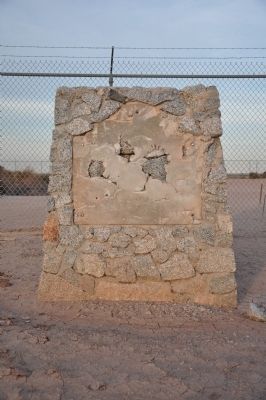
Bert Vaughn of Jacumba built the stone tower in 1922-23 to commemorate the pioneers and road and railroad builders who opened the area. In the 1930s W.T. Ratcliffe carved the stone animal figures which lurk in the rocks surrounding the tower, . . . — — Map (db m149171) HM
From 1862-70, Peter Larkin and Joe Stancliff used a stone house about a mile north of here as a store from which ox teams pulled wagons up a 30% grade. The San Diego and Fort Yuma Turnpike Co. used the site as a toll road station until 1876. The . . . — — Map (db m50232) HM
On Quechan Drive, on the right when traveling south.
Originally called Camp Calhoun, the site was first used as a U.S. Military Post in 1849. A fire destroyed the original buildings. By 1855 the barracks had been rebuilt. Called Camp Yuma in 1852 it became Fort Yuma after reconstruction. Transferred . . . — — Map (db m149168) HM
On Interstate 186, 0.2 miles south of Interstate 8, on the left when traveling south.
Alarcon's mission was to provide supplies for Francisco Coronado's expedition in search of the fabled Seven Cities of Cibola. The Spaniards led by Hernando De Alarcon ascended the Colorado River by boat from the Gulf of California past this point, . . . — — Map (db m88572) HM
On Picacho Road, on the right when traveling north.
Opened by placer miners after 1852, the gold mines expanded into hard rock quarrying by 1872. Picacho employed 700 miners at its peak from 1895 to 1900. Mill accidents, low ore quality, and the loss of cheap river transport with the building of . . . — — Map (db m50584) HM
On Grays Well Road, on the right when traveling east.
This unique plank road seven miles long was the only means early motorists had for crossing the treacherous Imperial Sand Dunes. The eight by twelve foot sections were moved with a team of horses whenever the shifting sands covered portions of the . . . — — Map (db m50682) HM
On Quechan Drive, 0.1 miles north of Quechan Road, on the left when traveling north.
In October 1780, Father Francisco Garces and companions began Mission La Purisima Concepcion. The mission/pueblo site was inadequately supported, colinists ignored Indian rights, usurped the best lands and destroyed Indian crops. Completely . . . — — Map (db m46896) HM
On West Mehring Road, 0.1 miles west of Imperial Road, on the right when traveling west.
To protect the Anza Trail where it forded the Colorado River, the Spanish founded a pueblo and mission nearby on January 7, 1781. Threatened with the loss of their land, the Quechans (Yumas) attacked this strategic settlement on July 17, 1781. The . . . — — Map (db m29057) HM
On Gold Rock Ranch Road at Walker Way on Gold Rock Ranch Road.
Pete Walters of Ogilby discovered the first gold vien at Gold Rock on January 6, 1884. From his little Mary claim began a gold camp which reached its peak development between 1893 and 1899 as Hedges, with 3200 residents. Nearly closed, 1900-10, it . . . — — Map (db m50581) HM
On California Route 168 at East Bishop Creek Road, on the left when traveling west on State Route 168.
On April 6, 1862, a battle took place around this site between newly arrived citizens of the Owens River Valley and the Paiute and Shoshone Indians, original inhabitants of the land. The reason for this battle is lost in obscurity, but brave men on . . . — — Map (db m628) HM
In 1883 the Carson & Colorado Railroad was built between Mound House (Near Carson City, Nevada) through Laws to Keeler, California, a distance of 300 miles. Laws Station was named in honor of Mr. R.J. Laws, Assistant Superintendent of the . . . — — Map (db m10333) HM
On California Route 190 at Badwater Road, on the right when traveling west on State Route 190.
Through this natural gateway the Death Valley Forty-Niners, more than one hundred emigrants from the middle west, seeking a shortcut to gold fields of central California, entered Death Valley in
December, 1849. All suffered from thirst and . . . — — Map (db m167508) HM
On California Route 190 at Cottonwood Canyon Road, on the right when traveling east on State Route 190.
In 1926 H.W. Eichbaum obtained a franchise for a toll road from Darwin Falls to Stovepipe Wells, the first maintained road into the valley from the west. It changed the area from mining to tourism and brought about the creation of Death Valley . . . — — Map (db m149164) HM
On California Route 190 at Borax Mill Road, on the left when traveling north on State Route 190.
On the marsh near this point borax was discovered in 1881 by Aaron Winters who later sold his holdings to W. T. Coleman of San Francisco. In 1882 Coleman built the Harmony Borax Works and commissioned his superintendent J. W. S. Perry to design . . . — — Map (db m158971) HM
On Stovepipe Wells Road, 0.8 miles west of Scotty's Castle Road, on the right when traveling west.
This waterhole, only one in the sand dune area of Death Valley, was at the junction of two Indian trails. During the bonanza days of Rhyolite and Skidoo it was the only known water source on the cross-valley road. When sand obscured the spot, a . . . — — Map (db m94591) HM
Near this monument, Jayhawker group of Death Valley Forty-Niners, gold seekers from middle west, who entered Death Valley in 1849 seeking short route to mines of Central California, burned their wagons, dried the meat of some oxen and, with . . . — — Map (db m89481) HM
On Highway 395, on the right when traveling south.
In the early part of the World War II, 110,000 persons of Japanese ancestry were interned in relocation centers by Executive Order No. 9066, issued on February 19, 1942.
Manzanar, the first of ten such concentration camps, was bounded by . . . — — Map (db m122703) HM WM
On Market Street at Webster Street, on the right when traveling west on Market Street.
“But if ever you come beyond the borders as far as the town that lies in a hill dimple at the foot of Kearsarge, never leave it until you have knocked on the door of the brown house under the willow-tree at the end of the village street, and there . . . — — Map (db m2955) HM
On Highway 395 south of Bush Street, on the right when traveling south.
One hundred thirty feet west of this site, Charles Putnam built the first cabin of permanent habitation in what is now Inyo County in August 1861. The building served as a home, trading post, hospital, and “fort” for early settlers, as well as a . . . — — Map (db m2957) HM
Near California Route 136, 9.6 miles east of U.S. 395, on the right when traveling east.
The Owens Lake Silver-Lead Furnace and Mill was built here by Col. Sherman Stevens in 1869 and used until March 1874. James Brady assumed its operation in 1870 for the Silver-Lead Company and built the town of Swansea. During the next few years the . . . — — Map (db m72576) HM
On Trona Wildrose Road just north of Valley Wells Road, on the right when traveling north.
In this area, several groups of midwestern emigrants, who had escaped from hazards and privations in Death Valley in 1849, sought to secure water from Searles Lake. When they discovered its salty nature, they turned northward and westward in . . . — — Map (db m93441) HM
On West Columbus Street at Isla Verde Street, on the right when traveling west on West Columbus Street.
Near this spot stood the last home of Elisha Stevens, noted American pathfinder and scout. Born in Georgia April 5, 1804, he learned blacksmithing during his youth. Drifting west he became a trapper on the Upper Missouri for more than two decades. . . . — — Map (db m231869) HM
Near R Street north of 19th Street. Reported missing.
Near this site stood the home of Alexis Godey, frontiersman and scout, who lived here from 1883 until his death on January 19, 1889. Born in St. Louis, Missouri in 1818, he acted as guide for John C. Frémont's expedition through the Kern area in . . . — — Map (db m51676) HM
This spring was on the old Indian Horsethief Trail and later (1834) Joe Walker Trail. The famished Manly-Jayhawk Death Valley parties (1849-50) were revived here after coming from Indian Wells through Last Chance Canyon. This was also a station on . . . — — Map (db m117039) HM
On Evans Road (State Highway 155), on the left when traveling west.
Kern County’s oldest residence. Built before Civil War by Thomas Fitzgerald as trading post at junction of two Indian trails. Present Greenhorn Road follows east – west trail (later McFarlane Toll Road) to Kern River mining districts. Town named . . . — — Map (db m25032) HM
On Isabella Walker Pass Road (State Highway 178 at milepost 88), on the right when traveling west. Reported missing.
In 1834 explorer Joseph R. Walker passed this junction of Indian trails after discovering nearby Walker Pass. Death Valley 49er parties here diverged west and south after their escape from Death Valley enroute to the California gold fields. Later . . . — — Map (db m207791) HM
On Aerospace Highway (State Highway 14 at milepost 62.6), on the right when traveling south.
Indian water hole on Joseph R. Walker trail of 1834 where Manly-Jayhawker parties of 1849 found their first water after five days of travel from Argus Range. During 1860's was site of stage and freight station from Los Angeles to Coso and Cerro . . . — — Map (db m50243) HM
On California Route 178, on the left when traveling east.
Near this spot at the confluence of the north and south forks of the Kern River the Theodore Talbot Party of Captain John C. Fremont’s third expedition to the West camped for several weeks during December 1845 and January 1846. The river was named . . . — — Map (db m25092) HM
This military post was established by the United States Army on June 24, 1854, to suppress stock rustling and for the protection of Indians in the San Joaquin Valley. As regimental headquarters of the First Dragoons, Fort Tejón was an important . . . — — Map (db m117523) HM
On David Road at North Wheeler Ridge Road, on the right when traveling east on David Road.
Six miles east of this point was the site of the Butterfield Stage Line station Sinks of Tejón. Operating through present Kern County during 1858-61, this famous line ran from St. Louis, Missouri to San Francisco until the outbreak of the Civil War. — — Map (db m144943) HM
On California Route 14 north of Nadeau Street, on the right when traveling north.
Just west of this point was the Southern Pacific terminus for the Twenty-Mule-Team Borax wagons that operated between Death Valley and Mojave from 1884 to 1889. The route ran from the Harmony Borax Mining Company works, later acquired by the . . . — — Map (db m123891) HM
In 1896 Eugene Garlock constructed a stamp mill near this spot for the crushing of gold ore from the Yellow Aster Mine on Rand Mountain. Known originally as Cow Wells, by prospectors and freighters during the 1880’s and early 1890’s, the town of . . . — — Map (db m51672) HM
On Butte Avenue at Highland Avenue on Butte Avenue.
The Yellow Aster, or Rand Mine, was discovered in April, 1895 by Singleton Burcham and Mooers. The town of Randsburg quickly developed followed by the supply town of Johannesburg in 1896. Both names were adopted from the profusion of minerals . . . — — Map (db m50461) HM
On Shafter Avenue north of Merced Avenue, on the right when traveling south.
The Shafter Cotton Research Station, established here in 1922 by the U.S. Department of Agriculture, developed the "Acala" varieties which were exceptionally well suited to the San Joaquin Valley. The quality of the acala cottons and the marketing . . . — — Map (db m52055) HM
On Vultee Street at East Lerdo Highway on Vultee Street.
This plaque at Shafter Airport commemorates the world's first man-powered flight to complete the Kremer Circuit, August 23, 1977. The circuit, a figure eight around two pylons one-half mile apart, was completed in six minutes, twenty-two seconds. . . . — — Map (db m131044) HM
On Old Town Road at Woodford Tehachapi Road, on the right when traveling north on Old Town Road.
The oldest settlement in Tehachapi Valley, known as 'Old Town,' was established here during the 1860s. It was long an important station on the road between Southern California and the San Joaquin Valley. The community began to decline when residents . . . — — Map (db m139964) HM
Near Basalt Road, 1 mile south of Tranquility Road.
In the Kawaiisu language, tomo-kahni means winter village. The site's location between the coast and desert allowed the site occupants to hold an important place for trade between these areas and the southern Central Valley. The sacred rock art . . . — — Map (db m92889) HM
On Bakersfield-Glennville Road, 6.5 miles south of California Route 155, on the right when traveling south.
One and one-half miles north of this point stood the Mountain House Station on the route of the Butterfield Stage. Operating through present Kern County during 1858-1861, this famous line ran from St. Louis, Missouri to San Francisco until the . . . — — Map (db m168616) HM
On 14th Avenue, 0.2 miles north of Elder Avenue, on the right when traveling north.
Here on May 11, 1880, during a dispute over land titles between settlers and railroad, a fight broke out during which seven men lost lives -- two deputy U.S. Marshals and five ranchers. Legal struggle over titles finally compromised. — — Map (db m154063) HM
On 19½ Avenue (State Highway 41) at Lacy Boulevard when traveling south on 19½ Avenue.
This restored adobe, second oldest in San Joaquin Valley, built by Daniel Rhoades, who came to California in 1846 by overland caravan. Rhoades and his brother, John, among organizers of the first expedition to rescue the Donner party at Donner Lake. . . . — — Map (db m66412) HM
On State Highway 29, 6 miles north of Middletown, on the right when traveling north.
Oldest building in Lake County. Erected of stone in 1853-4 by Robert Sterling, whose wife was first white woman in Coyote Valley. Rebuilt in 1894. Headquarters of the Guenoc Land Grant and the first store in the valley. — — Map (db m16127) HM
On Main Street, 0.1 miles east of California Route 29, on the left when traveling east.
Built in 1876 at the height of the quicksilver mining boom, the Lower Lake stone jail was a response to rapid town growth and the urgent need for civil order. Stephen Nicolai, one of the first stone masons in Lower Lake, built the jail from local . . . — — Map (db m8509) HM
On State Highway 26 at Hill Street, on the left when traveling north on State Highway 26.
The Old Bull Trail Road ran from Napa Valley to Middletown. It was built by volunteers in the 1850’s. A number of grades were 35 percent. It was an official road in 1861 and abandoned in 1868. St. Helena Toll Road also ran from same points. Was . . . — — Map (db m171749) HM
On Highway 20 at Reclamation Road, on the right when traveling south on Highway 20.
One-fourth mile west is the island called Bo-no-po-ti (Old Island), now Bloody Island. It was a place for native gatherings until May 15, 1850. On that date, a regiment of the 1st Dragoons of the U.S. Cavalry, commanded by Capt. Nathaniel Lyon and . . . — — Map (db m171748) HM
Peter Lassen opened the Lassen Emigrant Trail in 1848 when he led a 12-wagon emigrant train from Missouri to California. The route, which passed near this place, was extensively traveled during the years 1848-53 by emigrants seeking gold, adventure, . . . — — Map (db m10264) HM
On State Highway 395, on the left when traveling south.
This route was first used in 1852 by emigrants to Northern California seeking to avoid the hardships of the Lassen Trail. It crossed the desert from the Humbolt River in Nevada, passed this point, and proceeded over the mountains to the town of . . . — — Map (db m10269) HM
Near North Street, on the right when traveling north.
This meadow, now a city park, was a welcome stopping place on the Noble Emigrant Trail, pioneered by William H. Nobles in 1851 and first used in 1852. Here, emigrants en route to the Northern California mines were able to rest, refresh their stocks, . . . — — Map (db m10268) HM
Through this draw passed many covered wagons and gold seekers enroute to California over the Lassen Trail during 1848-1851. Approaching this location from the north, the trail passed what is now Bogard Ranger Station. Proceeding southward to Big . . . — — Map (db m22027) HM
On Santa Rosa Avenue at Alameda Street, on the right when traveling north on Santa Rosa Avenue.
The 135 Deodar Cedar trees were planted in 1885 by the Woodbury Family, the founders of Altadena. First organized by F.C. Nash in 1920, the "Mile of Christmas Trees" has been strung with 10,000 lights each holiday season through the efforts of . . . — — Map (db m143798) HM
On Saint Catherine Way north of Crescent Avenue, on the right when traveling north.
The Tuna Club of Avalon marks the birthplace of modern big game sportfishing. In 1898, led by Dr. Charles Frederick Holder, the club's founding members adopted the rules of conduct stressing conservationist ethics and sporting behavior. Today, their . . . — — Map (db m49678) HM
Near East Don Julian Road, on the right when traveling north.
Home of pioneer William Workman. Workman and co-owner John Rowland developed the 48,790-acre La Puenta Rancho. Workman and co-leader Rowland organized the first wagon train of permanent eastern settlers which arrived in Southern California on . . . — — Map (db m50981) HM
"El Campo Santo," this region's earliest known private family cemetery, was established in 1850 by William Workman. The miniature Classic Grecian mausoleum was built in 1919 by grandson Walter P. Temple. Included in this cemetery are the remains of . . . — — Map (db m50983) HM
On South Alameda Street, on the right when traveling north.
[The arch way leading to the grounds is flanked by two markers:]
Right Marker:
Domínguez Ranch House
Central portion built in 1826 by Manuel Domínguez.
Rancho San Pedro
Ten square leagues granted, . . . — — Map (db m64857) HM
On Wilmington Avenue north of Curtiss Street, on the right when traveling north.
About one half mile southeast of this spot, on Dominguez Hill in historic Rancho San Pedro, the first Air Meet in the United States was held during January 10-20, 1910. Subsequently, this area has evolved into one of the world's leading . . . — — Map (db m50979) HM
Near Willowbrook Avenue north of Myrrh Street, on the right when traveling south.
The original house of two rooms was built in 1869 by A.R. Loomis. Other rooms were added by successive occupants. It was marked as the "Oldest House in Compton" in 1955; purchased by the city June 11, 1957; and removed from 209 South Acacia Street . . . — — Map (db m50977) HM
Near Santa Anita Avenue south of Valley Boulevard, on the right when traveling south.
El Monte, on the bank of the San Gabriel River, played a significant part in California's early pioneer history. It was first an encampment on the Old Spanish Trail, an extension of the trail from Missouri to Santa Fe. By the 1850's some began . . . — — Map (db m162663) HM
On 119th Street west of Kornblum Avenue, on the right when traveling west.
It was here in the home of parents Murry and Audree that Brian, Dennis, and Carl Wilson grew to manhood and developed their musical skills. During Labor Day weekend 1961, they, with cousin Mike Love and friend Al Jardine, gathered here to record a . . . — — Map (db m59320) HM
On Lancaster Boulevard west of Beech Avenue, on the right when traveling west.
This buiding, erected by the Gilroy family in 1876, this building was purchased in 1902 by George T. Webber, who operated it as the Western Hotel. The Lancaster Chamber of Commerce was organized in its dining room. Between 1905 and 1913, . . . — — Map (db m53028) HM
Created in 1932 for the rowing events of the Xth Olympiad, the Stadium was the first manmade rowing course in the United States. Its width allowed four teams to race abreast, eliminating additional heats and allowing oarsmen to enter the finals at . . . — — Map (db m247818) HM
Near North Virginia Road north of East San Antonio Road.
The 27,000-acre Rancho was once part of an 18th-century Spanish land grant to soldier Manuel Nieto. The Monterey-style adobe was constructed in 1844 and served the Temple and Bixby families as headquarters for large-scale cattle and sheep ranching . . . — — Map (db m50988) HM
Dedicated to the firemen of the Los Angeles Fire Department - past, present and future - who, since 1871, by their courage and faithful devotion to duty have protected the lives and property of the citizens of Los Angeles from the ravages of fire. — — Map (db m51301) HM
On North Main Street north of Temple Street, on the right when traveling north.
Near this spot stood the Bella Union Hotel, long a social and political center. Here, on October 7, 1858, the first Butterfield Overland Mail stage from the East arrived 21 days after leaving St. Louis. Warren Hall was the driver, and Waterman . . . — — Map (db m59812) HM
Near 7th Street east of Hill Street, on the left when traveling east.
This was the site of Saint Vincent's College from 1868 to 1887. The college, now Loyola University, was founded by the Vincentian Fathers in 1865 and was the first institution of higher learning in Southern California. — — Map (db m121001) HM
On Elysian Park Drive at North Broadway, on the left when traveling north on Elysian Park Drive.
Spanish colonization of California began in 1769 with the expedition of Don Gaspar de Portolá from Mexico. With Captain Don Fernando Rivera y Moncada, Lieutenant Don Pedro Fages, Sgt. José Francisco Ortega, and Fathers Juan Crespí and Francisco . . . — — Map (db m115177) HM
Near Pacific Coast Highway (State Highway 1 at milepost 375), on the right when traveling south.
In 1893 the Southern Pacific Railroad Company completed its 4,720-foot wharf which served as a deep water port for the Los Angeles area. After San Pedro became Los Angeles' official harbor in 1897, shipping activity at Port Los Angeles declined. . . . — — Map (db m50984) HM
On Foothill Boulevard at Vaughn Street, on the right when traveling west on Foothill Boulevard.
Originally part of the San Fernando Mission lands, this ranch was purchased by David Wark Griffith, revered pioneer of silent motion pictures, in 1912. It provided the locale for many western thrillers, including "Custer's Last Stand", and was the . . . — — Map (db m122861) HM
On 5th Street just west of Harbor Boulevard, on the right when traveling west. Reported missing.
In 1923 the Marine Transport Industrial Workers Union 510, a branch of the Industrial Workers of the World (IWW), called a strike that immobilized 90 ships here in San Pedro. The Union protested low wages, bad working conditions, and imprisonment of . . . — — Map (db m157331) HM
On Sampson Way north of East 22nd Street, on the right when traveling north.
In 1852 German immigrant Augustus W. Timms obtained Sepulveda's Landing on the mudflats near here. He built a wharf, added a warehouse, corral and other facilities to service shipping and running of stages to Los Angeles. Timms was a pioneer in the . . . — — Map (db m50976) HM
On Foothill Boulevard, 0.1 miles north of Balboa Boulevard, on the right when traveling north. Reported missing.
This is the terminus of the Los Angeles-Owens River Aqueduct, which brings water 338 miles from the eastern slopes of the Sierra Nevada to the City of Los Angeles. Begun in 1905, the great aqueduct was completed November 5, 1913. The Mono Craters . . . — — Map (db m164815) HM
On Sierra Highway, 0.7 miles north of Foothill Boulevard, on the right when traveling north. Reported missing.
[This site was designated California Historical Landmark No. 1006 on May 11, 1992.
There are three rock and concrete bases which had displayed four different markers. The markers are now missing. The following marker was never placed:] . . . — — Map (db m184724) HM
On Foothill Boulevard at Bledsoe Street, on the right when traveling east on Foothill Boulevard.
This Cemetery, earlier known as Morningside Cemetery, is the oldest non-sectarian cemetery in San Fernando Valley. It was used from the early 1800's until 1939. It was legally abandoned in 1959. In this same year Mrs. Nellis S. Noble donated the . . . — — Map (db m157885) HM
Near Cary Avenue north of East Opp Street, on the left when traveling north.
Established at Wilmington in 1862, Drum Barracks became the United States military headquarters for Southern California, Arizona, and New Mexico. A garrison and base for supplies, it was a terminus for camel pack trains operated by the army until . . . — — Map (db m85152) HM
Near Pacific Coast Highway (State Highway 1), on the right when traveling south.
Designed by Stiles O. Clements in 1929, this Spanish Colonial Revival home contains the best surviving examples of decorative ceramic tile produced by Malibu Potteries. During its short existence from 1926 to 1932, Malibu Potteries made an . . . — — Map (db m118362) HM
On Manhattan Beach Boulevard at North The Strand, on the right when traveling west on Manhattan Beach Boulevard.
Designed by City Engineer A.L. Harris, this pier was constructed by the City of Manhattan beach during the years 1917-1920. The roundhouse building was added a year later. Harris' innovative design featured a rounded end to the pier, which helped it . . . — — Map (db m114457) HM
On Mt Baldy Road (at milepost 2), 3 miles north of North Mountain Avenue, on the right when traveling north. Reported missing.
The first hydroelectric installation in California for long-distance transmission of alternating current at high voltage was built in 1892 on San Antonio Creek below this spot by the San Antonio Light and Power Company organized by Dr. Cyrus . . . — — Map (db m149504) HM
Near Westmoreland Place north of Arroyo Terrace, on the right when traveling south.
Built in 1908, the David B. Gamble House is a tribute to the genius of architects Charles Sumner Greene and Henry Mather Greene. Its design represents a unique California lifestyle and is a masterpiece of American craftsmanship. In 1966 it was made . . . — — Map (db m59811) HM
On North Los Robles Ave north of East Colorado Boulevard (U.S. 66), on the right when traveling north.
Grace Nicholson, a noted collector and authority on American Indian and Asian Art and artifacts, supervised the design of her combination gallery and museum which was completed in 1929. It has been called an outstanding example of 1920s revival . . . — — Map (db m59818) HM
On East Arrow Highway at North Orange Grove Avenue, on the right when traveling west on East Arrow Highway.
Completed about 1854 and restored in 1939, this was the family home of Don Ygnacio Palomares, who with Don Ricardo Vejar was granted Rancho San José in 1837 by Governor Juan B. Alvarado. — — Map (db m128910) HM
On San Francisquito Canyon Road, 9 miles north of Copper Hill Road, on the right when traveling north.
The 185-foot concrete St. Francis Dam, part of the Los Angeles aqueduct system, stood 1½ miles north of this site. On March 12, 1928, the 185-foot high concrete dam collapsed just before midnight, sending 12½ billion gallons of water roaring down . . . — — Map (db m143722) HM
On Lang Station Road, 0.2 miles south of Soledad Canyon Road, on the right when traveling south.
On September 5, 1876, Charles Crocker, President of the Southern Pacific Company, drove a gold spike here to complete his company's San Joaquin Valley Line, the first rail connection of Los Angeles with San Francisco and Transcontinental lines. — — Map (db m122365) HM
Near Sierra Highway, 0.2 miles south of Newhall Avenue, on the right when traveling south.
This site was the location of a combination store, post office, telegraph office, tavern, and stage depot accommodating travelers during the Kern River gold rush in the early 1850s. A regular stop for Butterfield and other early California stage . . . — — Map (db m154273) HM
On Sierra Highway, 0.2 miles north of Placerita Canyon Road, on the right when traveling south.
In Placeritas Canyon, March 1842, Francisco Lopez y Arballo, while gathering wild onions from around an old oak, discovered gold particles clinging to the roots of the bulbs. It is estimated that $80,000 in gold was discovered as a result of this . . . — — Map (db m154258) HM
On Lyons Avenue just east of Interstate 5, on the right when traveling east.
In Placeritas Canyon, March 1842, Francisco Lopez y Arballo, while gathering wild onions from around an old oak, discovered gold particles clinging to the roots of the bulbs. It is estimated that $80,000 in gold was discovered as a result of this . . . — — Map (db m154260) HM
Near Placerita Canyon Road, 1.5 miles east of the Antelope Valley Freeway (California Route 14).
Francisco Lopez made California’s first authenticated gold discovery on March 9, 1842. While gathering wild onions near an oak tree in Placerita Canyon he found gold particles clinging to the roots of the bulbs. The San Fernando placers and nearby . . . — — Map (db m154261) HM
On Lyons Avenue east of Interstate 5, on the right when traveling east.
In 1875 the Star Oil Company, one of the predecessors of the Standard Oil Company of California, drilled its first Pico Canyon well, which yielded about one hundred barrels per day. The discovery resulted in the erection of the first commercial oil . . . — — Map (db m145418) HM
Near Pico Canyon Road, 3 miles west of Interstate 5.
Mentryville, named after Charles Alexander Mentry, who drilled California's first successful commercial oil well in 1876, was one of the first oil towns in the state. Mentry's restored home, barn and Felton School remain on the site where the . . . — — Map (db m165661) HM
On The Old Road just north of Rye Canyon Road, on the right when traveling south.
In Placeritas Canyon, March 1842, Francisco Lopez y Arballo, while gathering wild onions from around an old oak, discovered gold particles clinging to the roots of the bulbs. It is estimated that $80,000 in gold was discovered as a result of this . . . — — Map (db m154259) HM
On The Old Road east of Henry Mayo Drive, on the right when traveling south.
Approximately one-half mile south of this point was the adobe headquarters of Rancho San Francisco, originally built about 1804 as a granary of Mission San Fernando. The rancho was granted to Antonio de Valle in 1839. Here, in January 1850, William . . . — — Map (db m30667) HM
On Bluff Road north of Washington Boulevard, on the right when traveling north.
Near this site, on January 3, 1847, was fought the Battle of the Rio San Gabriel between American forces commanded by Capt. Robert F. Stockton, U.S. Navy Commander-in-Chief, Brig. Gen. Stephen W. Kearney, U.S. Army, and Californians commanded by . . . — — Map (db m218759) HM
On Whittier Boulevard (California Route 72) west of Pioneer Boulevard, on the right when traveling east.
Following the Mexican War, Pío Pico, last Mexican governor, acquired 9,000-acre Rancho Paso de Bartolo and built here an adobe home that was destroyed by the floods of 1883-1884. His second adobe casa, now known as Pío Pico Mansion, represents a . . . — — Map (db m50933) HM
On East Whittier Boulevard, on the right when traveling south. Reported missing.
The March 11, 1889 Act of the California Legislature authorized the establishment of a school for juvenile offenders. Dedication and laying of cornerstone was done by Governor R.W. Waterman on February 12, 1890. Officially opened as "Whittier State . . . — — Map (db m162164) HM
Dating prior to the 1860s, the Wassama Roundhouse was reconstructed in 1985 on the location of the previous four houses. In 1903, the third roundhouse was built using portions of the center pole from the two earlier houses. The Roundhouse served as . . . — — Map (db m46774) HM
The home of "Lord" Charlie Snowden Fairfax, pioneer and political leader of the 1850's, served California as an assemblyman (1853), Speaker of the Assembly (1854), and Clerk of the State Supreme Court (1856). Fairfax, a descendent of Scottish barons . . . — — Map (db m143401) HM
Near East Sir Francis Drake Boulevard east of Larkspur Landing Circle.
The Remillard Brick Company, of which the Green Brae Brick Kiln is the only surviving structure, was by 1900 the largest brickmaking firm on the Pacific Coast. The kiln is one of the few remaining examples of the Hoffman type kiln in the U.S. and . . . — — Map (db m63983) HM
On East Blithedale Avenue at Tower Drive, on the right when traveling west on East Blithedale Avenue.
Two miles west is the old saw mill, from which the city of Mill Valley acquired its name. It was constructed in the 1830's by John Reed, grantee of the Rancho Corte De Madera Del Presidio. The creek waters furnished the motive power for the mill, . . . — — Map (db m91858) HM
Near West Blithedale Avenue near Throckmorton Avenue, on the right when traveling east.
The Outdoor Art Club was designed in 1904 by Bernard Maybeck; internationally known American architect. Particularly notable for its unusual roof truss system, the building exemplifies Maybeck's creative use of natural materials. The Club, founded . . . — — Map (db m143402) HM
The Civic Center Complex was designed by Frank Lloyd Wright (1869-1959) near the end of his long career. The Administration Building was completed in 1962 and the Hall of Justice in 1970. They are the only government buildings designed by the . . . — — Map (db m32748) HM
On St. Vincents Drive near Highway 101, in the median.
In 1853, Timothy Murphy, Irish born pioneer of Marin County, gave 317 acres of land to Archbishop Alemany for educational purposes. Here the Sister of Charity in 1855 founded a school now called St. Vincent's School for Boys. It has been maintained . . . — — Map (db m143404) HM
On North San Pedro Road near Biscayne Drive, on the left when traveling east.
There are two markers on this monument
One of the earliest, largest and most productive Chinese fishing villages in California, China Camp was in operation by 1870. The Chinese immigrants and their descendants introduced the use of . . . — — Map (db m143403) HM
600 entries matched your criteria. Entries 101 through 200 are listed above. ⊲ Previous 100 — Next 100 ⊳