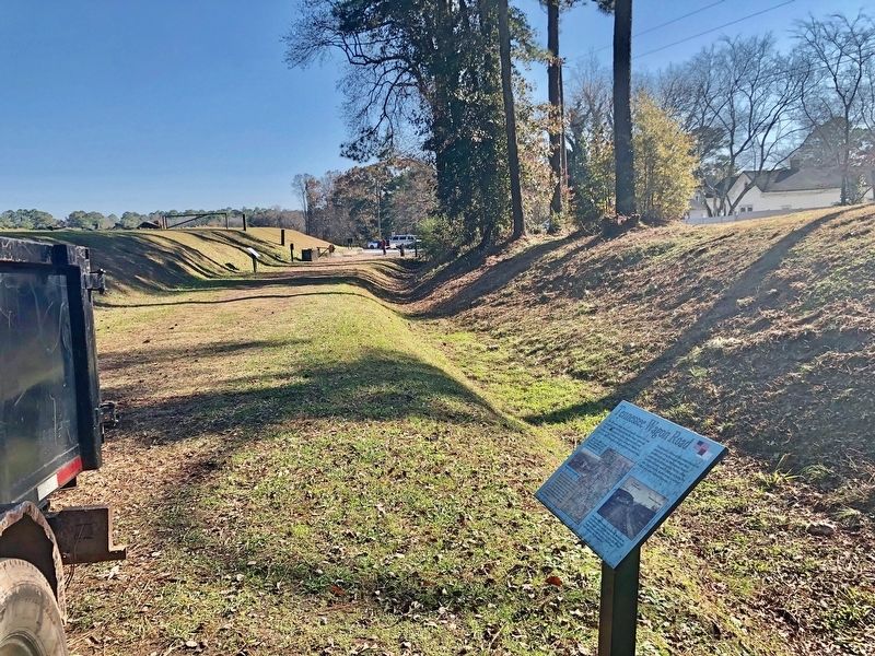
Near Old Allatoona Road SE, 2.9 miles east of Interstate 75, on the left when traveling south.
The Tennessee Wagon Road was a heavily traveled route that
passed through the Allatoona Mountain Range. It traversed
north to Chattanooga and south to Sandtown, which was
located on the Chattahoochee River just west of Atlanta. As it
ran south . . . — — Map (db m143025) HM
Near Old Alltatoona Road SE, 0.4 miles north of Allatoona Landing Road SE, on the right when traveling north.
The Allatoona Mountain range is the southernmost spur of the Appalachian Mountains. Years before the war, Lieutenant William T. Sherman spent time surveying this area for the U.S. Army; therefore, he understood the formidable military defense . . . — — Map (db m87374) HM
Near Old Allatoona Road SE, 0.4 miles Allatoona Landing Road SE, on the right when traveling north.
Allatoona Pass is the site of a significant and bloody Civil War battle that took place after the fall of Atlanta in September 1864. With no city to defend, the Confederate Army retreated from Atlanta and began a new tactic of attacking Federal . . . — — Map (db m87341) HM
Near Old Alltatoona Road SE, 0.4 miles north of Allatoona Landing Road SE, on the right when traveling north.
At this approximate location stood the Crow's Nest, a sixty-foot tall Georgia Pine surmounted by a signal platform. Before and after the battle, information to General Sherman was sent by signal flag communication from this platform to signal . . . — — Map (db m87378) HM
Near Old Alltatoona Road SE, 0.4 miles north of Allatoona Landing Road SE, on the right when traveling north.
The immediate level, directly below the top, is a berm or shoulder excavated to prevent earth from falling into the cut and blocking the tracks and corresponds to the top of the rock strata. Beyond this berm, the Western and Atlantic Railroad . . . — — Map (db m87372) HM
Near Old Alltatoona Road SE, 0.4 miles north of Allatoona Landing Road SE, on the right when traveling north.
The eastern redoubt was constructed with six-foot tall earth parapets and a six-foot deep ditch surrounding the fort on all sides. Gun embrasures allowed cannon to be fired at the enemy from this defensive position. Under the command of . . . — — Map (db m87377) HM
On Old Alltatoona Road SE, 0.4 miles north of Allatoona Landing Road SE, on the right when traveling north.
At this point, a crude wooden bridge spanned the cut about 90 feet above the railroad tracks. It was constructed by felling two pine trees across the cut, planking over them and adding a handrail. During the battle, Private Edwin R. Fullington . . . — — Map (db m87380) HM
Near Old Allatoona Road SE, 0.4 miles north of Allatoona Landing Road SE, on the right when traveling north.
This battlefield, along with its memorial ground, is dedicated to the Union and Confederate forces that fought here on October 5, 1864. During the battle, units representing five Union states and six Confederate states were present. Most of the . . . — — Map (db m87346) HM
Near Old Allatoona Road SE, 0.4 miles north of Allatoona Landing Road SE, on the right when traveling north.
Chartered by the State of Georgia in 1837, workmen completed the Western & Atlantic Railroad in 1850 over a winding 137-mile route from Atlanta, Georgia, to Chattanooga, Tennessee. At Allatoona, massive quantities of earth and stone were removed . . . — — Map (db m87344) HM
Near Old Allatoona Road SE, 0.4 miles north of Allatoona Landing Road SE, on the right.
In 1866, George N. Barnard photographed Allatoona looking north from approximately the same location as this marker. The Western & Atlantic Railroad from Atlanta to Chattanooga penetrated the Allatoona Mountain range at this point through a 175 . . . — — Map (db m87338) HM
Near Old Allatoona Road SE, 0.4 miles Allatoona Landing Road SE, on the right when traveling north.
The Georgia State Parks and Historic Sites, Redtop Mountain State Park, the U.S. Army Corps of Engineers, the Friends of Georgia State Parks and Historic Sites, and the Etowah Valley Historical Society welcome you to Allatoona Pass Battlefield. . . . — — Map (db m87340) HM
On Cassville Road (Georgia Route 293) 0.1 miles south of Goodyear Avenue, on the right when traveling south.
Johnston’s forces [CS] retreated southward from Cassville along this road, to Allatoona Mountains, south of the Etowah, May 20, 1864. They were immediately followed by Schofield’s 23d Corps, [US] which encamped in this vicinity. While here, troops . . . — — Map (db m21679) HM
Near Old Allatoona Road Southeast, 1.5 miles east of Interstate 75, on the left when traveling east.
“For the noble dead the army mourns. A nation mourns for the living. Honor and respect will await them wherever they shall be known as faithful soldiers who have for their dearest rights so often gone through the fires of battle and the baptism . . . — — Map (db m240090) HM WM
On South Tennessee Street (Georgia Route 293) 0 miles north of Brook Drive, on the right when traveling north.
Lawyer, U.S. Attorney for District of Georgia, 1869-70; U.S. Attorney General, 1870-71. Born Portsmouth, N.H., February 23, 1821; died in Cartersville, Georgia, December 21, 1880; buried Oak Hill Cemetery. Served as Confederate soldier in Georgia . . . — — Map (db m60385) HM
Near West Main Street (Georgia Route 113) 0.1 miles west of South Public Square, on the right when traveling west.
Lawyer, U.S. Attorney for District of Georgia, 1869-70; U.S. Attorney General, 1870-71. Born Portsmouth, N.H., February 23, 1821; died in Cartersville, Georgia, December 21, 1880; buried Oak Hill Cemetery.
Served as Confederate soldier in Georgia . . . — — Map (db m190656) HM
On South Tennessee Street (Georgia Route 293) 0.1 miles north of Brook Drive, on the right when traveling north.
Amos Tappan Akerman, born in Portsmouth, New Hampshire, graduated from Dartmouth College and moved south. While tutoring the children of US Senator and former US Attorney General John Macpherson Berrien in Savannah, Akerman studied law and became an . . . — — Map (db m171181) HM
Near West Main Street (Georgia Route 113) west of South Public Square, on the right when traveling west.
Asa G. Candler, founder of the Coca-Cola Company, moved from Carroll County, Georgia to Cartersville and served as an apprentice to learn the apothecary profession. He studied under Dr. John Best and Dr. William Kirkpatrick between 1870 and 1873 on . . . — — Map (db m190704) HM
On West Cherokee Avenue at North Erwin Street, on the right when traveling west on West Cherokee Avenue.
Originally Cass, Bartow County was created by Act of Dec. 3, 1832 from Cherokee County. The name was changed Dec. 6, 1861 to honor Gen. Francis S. Bartow (1816-1861), Confederate political leader and soldier, who fell mortally wounded at the First . . . — — Map (db m40585) HM
Near Unnamed road, 1 mile south of Georgia Route 20 Spur.
After the fall of Atlanta, hoping Sherman would follow, Hood moved his Confederate army north, sending French’s Division to fill the railroad cut at Allatoona, and burn the railroad bridge over the Etowah River, to hamper Sherman’s movement. . . . — — Map (db m21843) HM
Near West Main Street (Georgia Route 113) west of South Public Square, on the right when traveling west.
Lawyer, journalist, humorist. Born Lawrenceville, Georgia, June 15, 1826; died Cartersville, Georgia, [August] 24, 1903.
Major in Confederate Army, former Mayor of Rome, Georgia. Writing career started in 1861 under pen name “Bill Arp". A . . . — — Map (db m190672) HM
Near West Main Street (Georgia Route 113) west of South Public Square, on the right when traveling west.
Lawyer; Justice, Georgia Court of Appeals; Chief Justice, Supreme Court of Georgia.
Born September 25, 1946. First African American Lawyer to practice law in Cartersville, Bartow County: and to serve as President of Bartow County Bar Association. . . . — — Map (db m190660) HM
Near West Main Street (Georgia Route 113) west of South Public Square, on the right when traveling west.
Author. Born Elbert County, Georgia, May 17, 1869; died Atlanta, Georgia, February 7, 1935; buried at "In the Valley", Bartow County, Georgia.
Wrote 28 novels, including "Circuit Rider's Wife," upon which the move "I'd Climb the Highest Mountain" . . . — — Map (db m190666) HM
On Georgia Route 293 at Old River Road, on the right when traveling north on State Route 293.
Four miles east, in the gorge of the Etowah River, are the picturesque ruins of the once flourishing town of Etowah, developed by Mark Cooper around his iron furnace and rolling mill. The furnace was built in 1844, following one built in 1837 on . . . — — Map (db m56315) HM
On Indian Mound Road, 0.8 miles east of Douthit Ferry Road, on the left when traveling south.
For over 100 years Etowah Indian Mounds were the Tumlin Mounds. In 1832 Col. Lewis Tumlin came to Cass County (Bartow) and drew the land lot that contained the mounds. Col. Tumlin served as county sheriff from 1834 to 1840. As young soldiers, Gen. . . . — — Map (db m13471) HM
The Confederacy sought iron and munitions eagerly, which quickly brought prosperity to Etowah. Patriotic key workers, though exempt from army duty, enlisted, and loss of their skill hampered production.
Mark Cooper sold the works in 1862. In the . . . — — Map (db m56318) HM
On Rockmart Highway (Georgia Route 113) 0.4 miles east of Dallas Highway SW (Georgia Route 61), on the right when traveling west.
On this site from 1844-1879 stood the plantation of Maj. John Sharpe Rowland and Frances Lewis Rowland. The plantation comprised some 2,500 acres. Rowland’s Ferry was located just northeast of here at the mouth of Pettit’s Creek. The Rowlands also . . . — — Map (db m68747) HM
Near West Main Street (Georgia Route 113) west of South Public Square, on the right when traveling west.
Planter, land speculator, entrepreneur. Born South Carolina, November 24, 1780; died Milledgeville, Georgia, July 2, 1861.
Never lived in Cartersville, Georgia, but it is named in his honor. He has been cited as the richest landowner and . . . — — Map (db m190661) HM
On Joe Frank Harris Parkway (U.S. 41) at Old River Road, on the right when traveling north on Joe Frank Harris Parkway.
Atop the hill to the east was a fort that protected the river bridge, part of the rail line which enabled Sherman to supply his army during the Atlanta Campaign. The rail line has been moved downstream, but piers in the river mark the site of the . . . — — Map (db m10894) HM
On Tennessee Road (U.S. 411) at Old Tennessee Road, on the right when traveling north on Tennessee Road.
Dr. William H. Felton and his wife, Rebecca Latimer, lived from 1853 until 1905 in the house east of this marker.
A physician, minister and noted orator, Dr. Felton was the leader of the Independent Revolt from the State Democratic Party in . . . — — Map (db m13483) HM
Near West Main Street (Georgia Route 113) west of South Public Square, on the right when traveling west.
Lawyer, legislator, soldier. Born Savannah, Georgia, September 6, 1816; died Manassas Battlefield, Virginia, July 21, 1861; buried Laurel Grove Cemetery, Savannah, Georgia.
Served two terms in State Legislature and one term in State Senate, from . . . — — Map (db m190659) HM
On Georgia Route 293, 0.1 miles north of Old River Road, on the right when traveling north.
This site was donated by Arnold Milner, owner of a farm on the Etowah River, to be used for a church and cemetery for his family and friends. Friendship Presbyterian Church held its first services here on February 26, 1843. The church met here until . . . — — Map (db m56367) HM
On West Main Street (Georgia Route 113) at Friendship Plaza, on the right when traveling west on West Main Street.
The nearby marble shaft has the unique distinction of having been erected by a debtor in honor of his creditors. Losses during the panic of 1857 forced Mark A. Cooper, proprietor of the Etowah Iron Works, to offer this property for sale to satisfy a . . . — — Map (db m11627) HM
Near West Main Street (Georgia Route 113) west of South Public Square, on the right when traveling west.
Lawyer, politician, soldier, planter, humanitarian. Born Habersham County, Georgia, June 28, 1824; died Cass Station, Georgia, May 22, 1884. Captain in Mexican War. Georgia Legislator, 1849. Delegate to Georgia Secession Convention, 1861. Voted not . . . — — Map (db m190698) HM
On South Public Square, 0.1 miles south of West Cherokee Avenue, on the right.
In Memory & In Honor
of Those Who Serve And Protect Our Great Country
This memorial given by Frank Perkins, Cartersville Monument Co & Steve Owen, Owen Funeral Home
9-11-2003 — — Map (db m65822) WM
Near West Main Street (Georgia Route 113) west of South Public Square, on the right when traveling west.
Legislator, Georgia Governor.
Born February 16, 1936, Atco, Bartow County, Georgia. Elected member of Georgia House of Representatives from several counties, including Bartow County for 18 years, serving as Chairman of the Appropriations . . . — — Map (db m190667) HM
On West Cherokee Avenue, 0.1 miles west of South Bartow Street, on the right when traveling east.
Sam P. Jones was born October 16, 1847, in Oak Bowery, Alabama; he moved to Cartersville with his parents in 1856. After his admission to the Georgia Bar in 1868 he married Laura McElwain. In 1872 he was licensed as a Methodist Minister. His . . . — — Map (db m21695) HM
Near West Main Street (Georgia Route 113) west of South Public Square, on the right when traveling west.
Thoroughbred Horse Racing Hall of Fame Trainer. Two Kentucky Derby Winners. Born February 27, 1901, Argentina, died December 16, 1991, buried Oak Hill Cemetery. Inducted into Hall of Fame, November 9, 1980, by Thoroughbred Club of America at . . . — — Map (db m190670) HM
Near Old Allatoona Road Southeast, 1.5 miles east of Interstate 75, on the left when traveling east.
Here loyal men fell defending the United States and Freedom
October 5, 1864
The price of victory was 86 killed, 243 wounded, 48 missing
Illinois Volunteer Infantry Regiments 7th 9th 12th 50th 57th 93rd — — Map (db m240084) HM WM
Near Old Allatoona Road SE, 2 miles east of Interstate 75, on the left when traveling east.
The "Star Fort" was constructed of 6-foot high earthworks or parapets, with a 6-foot deep trench completely surrounding the fort. The earthen walls were topped with interlacing railroad ties forming a multi-pointed star, giving the fort its . . . — — Map (db m77959) HM
Initiated in Cartersville Lodge No. 63 on June 2, 1891, passed on June 30, & raised on
Aug. 4, 1891. Was W.M. 1893, 1894, 1899 & 1901. Jr. Grand Warden of the Grand Lodge of GA in 1897 & 1898. Judge of Cartersville City Court, President of City . . . — — Map (db m53015) HM
Near West Main Street (Route 113) west of South Public Square, on the right when traveling west.
Teacher, Missionary to China. Born December 12, 1840, Abermarle County, Virginia. Died December 24, 1912 en route from China at Kobe, Japan, buried Crewe, Virginia. Moved here in 1871 to open Cartersville Female Seminary, which she and Anna C. . . . — — Map (db m190671) HM
Near West Main Street (Georgia Route 113) west of South Public Square, on the right when traveling west.
Soldier, politician. Born Spartanburg, South Carolina, November 15, 1836; died New York City, July 6, 1896; buried Oak Hill Cemetery. Resigned from West Point, Class of 1861 to join Confederate Army, roommate of General George Armstrong Custer. Was . . . — — Map (db m190703) HM
Near West Main Street (Georgia Route 113) west of South Public Square, on the right when traveling west.
Lawyer, politician, businessman. Born Hancock County, Georgia, April 20, 1800. Died Bartow County, Georgia, March 17, 1885. Buried in Oak Hill Cemetery.
Major in U.S. Army during Seminole Wars in 1836. State legislator from Putnam County, . . . — — Map (db m190662) HM
On Old River Road, 2.5 miles east of Joe Frank Harris Parkway (U.S. 41), on the left when traveling north.
These ruins of an old iron furnace built by Moses Stroup are all that remain of Cooper's Iron Works, developed by Mark Anthony Cooper, pioneer industrialist, politician, and farmer. Cooper was born in 1800 near Powelton, Ga. Graduating from S.C. . . . — — Map (db m56319) HM
On Euharlee Road at Milam Bridge Road, on the right when traveling east on Euharlee Road.
The covered structure over the Etowah here, was burned by Jackson's [CS] Cav. May 21, 1864, the day after Johnston´s [CS] passage of the river at State R.R. Bridge. May 23rd, the 2 pontoon bridges intended for the passage of Schofield's 23d A.C. . . . — — Map (db m13840) HM
Near Old Allatoona Road Southeast, 1.5 miles east of Interstate 75, on the left when traveling east.
In tribute to the officers and men of the Fourth Regiment Minnesota Volunteer Infantry, Lt. Col. John E. Tourtellotte, commanding. Who held their ground on October 5, 1864. 11 killed. 33 wounded. — — Map (db m240083) HM WM
Near Old Allatoona Road Southeast, 1.5 miles east of Interstate 75, on the left when traveling east.
Honor to those men who fought here on Oct. 5 1864.
4th Reg. Col. Thomas N. Adaire
7th Reg. Capt. J.D. Harris
35th Reg. Col. William S. Barry
36th Reg. Col. William Witherspoon
39th Reg. Col. P.J. Durr
46th Reg. Col. William H. . . . — — Map (db m240088) HM WM
Near Old Allatoona Road Southeast, 1.5 miles east of Interstate 75, on the left when traveling east.
On this field of honor Missouri soldiers of Cockrell's elite brigade fought and died for southern independence. October 5, 1864. 91 killed. C.S.A. — — Map (db m240087) HM WM
Near Old Allatoona Road Southeast, 1.5 miles east of Interstate 75, on the left when traveling east.
In honor of the brave men of the North Carolina 29th and 39th Infantry Regiments who fought and died here in defense of their families, homes, country and for southern independence. — — Map (db m240089) HM WM
Near Old Allatoona Road Southeast, 1.5 miles Interstate 75, on the left when traveling east.
The 5th Ohio Cavalry served throughout the Atlanta Campaign. Acting as the eyes of the Union forces, elements of the 5th Ohio were posted to Allatoona on picket and communication duty where they fought in the Battle of Allatoona Pass on October . . . — — Map (db m240081) HM WM
Near North Erwin Street, 0.1 miles east of Cassville Road (Georgia Route 293).
PMB Young was born in Spartanburg, S.C., on November 15, 1836. His parents were Dr. Robert Maxwell and Elizabeth Caroline (Jones) Young. The Young family came to Georgia in 1839. He graduated from Georgia Military Institute at Marietta in 1856; . . . — — Map (db m21680) HM
On North Public Square, 0 miles north of West Main Street (Georgia Route 61), on the right when traveling north.
Killed in Action - 9 November 1967 - Republic of Vietnam
PFC Gentry was a crew member of an M113 Armored Personnel Carrier assigned to B Troop, 1st Squadron, 1st Cavalry, of the Americal Division in the Republic of Vietnam. While engaged in an . . . — — Map (db m67110) WM
On Rockmart Highway (Georgia Route 113) 0.1 miles west of Kincannon Road SW, on the right when traveling west.
Geary's (2d) Div., 20th A.C. [US], having crossed the Etowah, May 23, drove Ross' cavalry [CS] beyond the creek, May 24, 1864. This covered the march of
the rest of the corps S. to Burnt Hickory P.O., in which Geary's troops joined - being relieved . . . — — Map (db m13946) HM
Near West Main Street (Georgia Route 113) west of South Public Square, on the right when traveling west.
Journalist, politician. Born Decatur, Georgia, June 10, 1835; died Atlanta, Georgia, January 24, 1930; buried Oak Hill Cemetery.
While husband, William H. Felton, served in U.S. Congress, 1875-81, she served as advisor and political strategist. . . . — — Map (db m190663) HM
Near Old Allatoona Road, 2 miles east of Interstate 75, on the left when traveling east.
Some 200 yards behind this marker was an earthen redoubt that protected the Federal defenses and the Star Fort. The redoubt was commanded by Colonel Richard Rowett and manned by the 39th Iowa, 7th Illinois, five companies of the 93rd Illinois . . . — — Map (db m78099) HM
On Simpson Circle NE at Harvey Knight Road NE, on the right when traveling north on Simpson Circle NE.
On this site from 1844–1872 stood the most exclusive resort in Georgia. In 1843 Maj. John Sharpe Rowland and his wife Frances Machen Lewis Rowland purchased 2,400 acres and built a health resort which included such amenities as a ten pin . . . — — Map (db m70986) HM
Near West Main Street (Georgia Route 113) west of South Public Square, on the right when traveling west.
Professional baseball player. Born 1913; died 1970, Cartersville, Georgia; buried Sunset Memory Gardens.
Began his career at Atco, Georgia, playing in the textile semi-pro league. Drafted by the Detroit Tigers, he played in the major leagues for . . . — — Map (db m190700) HM
Near West Main Street (Georgia Route 113) west of South Public Square, on the right when traveling west.
Evangelist, Methodist Minister. Born Oak Bowery, Alabama, October 15, 1847; died Oklahoma, October 15, 1906; buried Oak Hill Cemetery.
Having failed as an alcoholic lawyer, promised his dying father to stop drinking. Found religion and became the . . . — — Map (db m190668) HM
On West Main Street at School Street, on the right when traveling west on West Main Street.
For 20 years, thousands came annually to this site, attracted by the magnetic personality and forceful eloquence of Sam Jones, renowned Evangelist and Christian crusader.
Here he built, in 1886, at his own expense, a large open-air structure, . . . — — Map (db m40571) HM
Near West Main Street (Georgia Route 113) west of South Public Square, on the right when traveling west.
On April 12, 1862, Union spies led by James Andrews hijacked the locomotive General in Kennesaw, GA. The raiders ran north in hopes of burning bridges, ripping up rails, and cutting telegraph wires on the Georgia owned W&A RR. The plan would prevent . . . — — Map (db m190652) HM
On West Main Street (Georgia Route 113) at Friendship Plaza, on the right when traveling west on West Main Street.
Side 1 This monument is erected by Mark A. Cooper, Proprietor at Etowah, as a Grateful tribute to the Friendship and Liberality of those whose names are hereon inscribed, which prompted them to aid him in the prosecution and development of the . . . — — Map (db m11630) HM
Near West Main Street (Georgia Route 113) west of South Public Square, on the right when traveling west.
Lawyer, minister, politician. Born Elbert County, Georgia, October 9, 1811. Died Cartersville, Georgia, December 17, 1877; buried Cassville Cemetery.
Opened law office in Cassville, Georgia in 1836, argued first case before Georgia Supreme Court . . . — — Map (db m190658) HM
Near West Main Street (Georgia Route 113) west of South Public Square, on the right when traveling west.
Doctor, minister, politician. Born Lexington, Georgia, June 19, 1823; died Cartersville, Georgia, September 24, 1909; buried Oak Hill Cemetery.
U.S. Congressman, 1875-1881. Leader of Independent party movement, advocate of reform of prison system . . . — — Map (db m190665) HM
Near West Main Street (Georgia Route 113) west of South Public Square, on the right when traveling west.
Lawyer, planter, politician. Born Savannah, Georgia, January 1, 1809: died Savannah, December 20, 1865, buried Laurel Grove Cemetery, Savannah, Georgia.
Served in U.S. Congress, 1843-45. Appointed in 1845 by President James K. Polk charge d' . . . — — Map (db m190673) HM
Near Old Allatoona Road Southeast, 1.5 miles east of Interstate 75, on the left when traveling east.
On 5 October 1864, brave men from Wisconsin defended the star fort and the neighboring rations depot from repeated Confederate attacks. Although the garrison was heavily outnumbered, they tenaciously held the fort.
Their courage saved the . . . — — Map (db m240082) HM WM
On Cassville Road NW, on the right when traveling south.
1. On May 19, 1864, Confederate General Joseph E. Johnston tricked Union General William T. Sherman into dividing his forces at Adairsville and sending the XXIII corps under John M. Schofield across the Gravelly Plateau to Cassville. 2. Johnston . . . — — Map (db m13484) HM
On Cassville Road NW (Old Route 41), on the right when traveling south.
National Historic Site Atlanta Campaign Cassville On May 19, 1864, Johnston, entrenched on the ridge east of this marker, planned to give battle but Sherman threatened his flank and his corps commanders objected to the position. He therefore . . . — — Map (db m12368) HM
On Joe Frank Harris Parkway (U.S. 41) at Willow Lane NW, on the right when traveling north on Joe Frank Harris Parkway.
Gen. Joseph E. Johnston’s forces [CS], reaching Cassville May 18, 1864 from Resaca, 30 m. N., took positions on ridge W. of the town & prepared to
withstand the advancing Federals. May 19th: Pursuant to this intention, Hood's corps [CS] moved N. . . . — — Map (db m13940) HM
On Cassville-White Road at Shinall Gaines Road NW, on the right when traveling east on Cassville-White Road.
In this cemetery are buried about 300 unknown Confederate soldiers who died of wounds or disease in the several Confederate hospitals located in Cassville. These hospitals operated from late 1861 until May 18, 1864, then moved south out of the path . . . — — Map (db m13978) HM
On Mac Johnson Road at Alisha Circle, in the median on Mac Johnson Road.
The three corps of Gen. Joseph E. Johnston’s Army [CS] were withdrawn from N. & W. of Cassville to this ridge, E. & S. of the town.
Hardee was posted astride the R.R. near Cass Station on the S.; Polk centered here & Hood’s line skirted the . . . — — Map (db m30561) HM
Near Chunn Facin Road NW at Shinall Gaines Road, on the right when traveling east.
Front:
Dedicated to the
memory of
our Southern heroes
by the Ladies
Memorial Association
of Cassville
AD 1878.
Right:
Is it death to fall for
Freedom's Cause.
Left:
Rest in peace our own
Southern . . . — — Map (db m87331) WM
On Mac Johnson Road NW, 0.4 miles north of Joe Frank Harris Parkway (U.S. 41), on the left when traveling north.
The William Neal McKelvey residence - 1864. A Council of War held here May 19, discussed the advisability of holding the position E. & S. of Cassville by the Confederate army. Present were: Gen. Joseph E. Johnston; Lt. Gen. Polk; Lt. Gen. John B. . . . — — Map (db m15457) HM
Near Cassville-White Road at Shinall Gaines Road NW.
Gen. William Tatum Wofford (June 28, 1824 - May 22, 1884), Cav. Capt. in the Mexican War, Col. and Brig. Gen. in the Confederate Army, is buried here. After Fredericksburg he succeeded to the command of Gen. Thomas R. R. Cobb, who was mortally . . . — — Map (db m30569) HM
On Joe Frank Harris Parkway (U.S. 41) at Cassville Road, on the right when traveling north on Joe Frank Harris Parkway.
May 19, 1864: Butterfield's (3d) Div., 20th A.C. [US], moving S.E., from McDow's, left the road here & marched to the Hawkins Price house, enroute to
Kingston. The 1st & 2nd Divs. [US], on roads W., had the same objective - an erratic move by . . . — — Map (db m13929) HM
Near Mac Johnson Rd. NW, on the left when traveling north.
Here the night of May 19, 1864, the Confederate Generals Joe Johnston, Leonidas Polk and John B. Hood, held a conference, the results of which caused the Confederates to abandon Cassville and to move south of the Etowah. Although Johnston intended . . . — — Map (db m15454) HM
On Joe Frank Harris Parkway (U.S. 41) 0.1 miles south of Willow Lane, on the right when traveling south.
Noble Hill Rosenwald School, now known as Noble Hill-Wheeler Memorial Center, built in 1923 as the first standard school for Black children in Bartow County School System. The school closed in 1955 when all schools for Black Children in Bartow . . . — — Map (db m13456) HM
On Joe Frank Harris Parkway (U.S. 41) at Willow Lane NW, on the right when traveling north on Joe Frank Harris Parkway.
May 19, 1864: Skirmishers of Polk's A.C. [CS] withdrew from this ridge E. to Cassville when pressed back by Butterfield's (3d) Div., 20th A.C. [US], from the Hawkins Price house. Battery C, 1st Ohio Lt. Art., supported by 73d Ohio, 19th Mich. & . . . — — Map (db m13941) HM
On Fire Tower Road at Gaddis Road, on the right when traveling east on Fire Tower Road. Reported missing.
On Chapman Hill; a school for boys established Jan. 1854. A large three-story brick bldg. flanked by two-story wings. Burned 1856; rebuilt 1857, destroyed by
Federal forces Oct. 12, 1864. This, & the Methodist Female College 3/4 mi. N.E., were the . . . — — Map (db m13942) HM
On Cassville Road NW, on the left when traveling south.
County seat Cass County 1832-1861. First decision Supreme Court of Georgia, 1846. Name changed to Manassas 1861. Town burned by Sherman 1864 and never rebuilt. — — Map (db m12359) HM
On Cassville Road NW (Old Route 41), on the left when traveling south.
In this valley was once situated the proud town of Cassville, begun in July 1833, as the seat of justice for Cass County and soon the center of trade and travel in the region recently comprising the Cherokee Nation. Both the county and town where . . . — — Map (db m12371) HM
On Old Allatoona Road at Allatoona Landing Road, on the left when traveling south on Old Allatoona Road.
Lt. Gen. John B. Hood, Army of Tenn. [CS], while enroute N. from Palmetto, Ga., sent Lt. Gen. A.P. Stewart's Corps to destroy the State R.R. from Big Shanty to the Etowah River. Stewart seized Big Shanty and Acworth on the 3d, and French's Div. was . . . — — Map (db m13935) HM
On Main Street (Georgia Route 293) at Gaston Westbrook Avenue, on the left when traveling north on Main Street.
Named for Joseph Emerson Brown, Gov. of Ga., 1857-1865, U.S. Senator, 1880-1891. Known as Stegall's Station prior to 1889; site of the Bartow Iron Works. May 20, 1864: Gen. Joseph E. Johnston's forces camped here after retreating from Cassville and . . . — — Map (db m10907) HM
On North Main Street SE (Georgia Route 293) at Sandtown Road SE, on the right when traveling west on North Main Street SE.
On Allatoona Creek in this vicinity, a Federal block-house, guarding State R.R. bridge, was garrisoned by Companies E, F, and I, of the 18th Wisconsin Regt. Oct. 5, 1864, while retreating from Allatoona, 2 mi. N., French’s Div. of Stewart’s A.C. . . . — — Map (db m105104) HM
On Covered Bridge Road SW, 0.1 miles west of Covered Bridge-Stilesboro Road SW, on the right when traveling west.
In 1886 the county contracted with Washington W. King, son of freed slave and noted bridge builder Horace King, and Jonathan H. Burke for the construction of this 138-foot bridge. It was adjacent to a mill owned by Daniel Lowry, of which the . . . — — Map (db m8478) HM
On Hall Station Road, 0.1 miles south of Old Hall Station Road, on the right when traveling south.
May 18, 1864. Howard’s 4th Corps leading, & two divs. of Palmer’s 14th [US], moved from Adairsville on this direct road to Kingston. They were halted just outside of Adairsville to await the support of the 15th A. C. of McPherson’s Army of the . . . — — Map (db m40581) HM
On East Railroad Street at Shaw Street, on the left when traveling west on East Railroad Street.
First Decoration, or Memorial Day, was observed in Kingston in late April of 1865, and has been a continuous observance here since that day, the only such record held by any community in this Nation. The first Memorial, or Decoration Day, was . . . — — Map (db m13976) HM
On Kingston Highway (Georgia Route 293) at Martin Circle, on the left when traveling west on Kingston Highway.
May 18, 1864. Lt. Gen. Wm. J. Hardee's A. C. marched from Adairsville on the road parallel to the State R.R. -- turning E. on this rd. to join Polk's & Hood's corps [CS] at Cassville, which had moved on the direct Adairsville - Cassville road. . . . — — Map (db m13962) HM
On Law Road, 1.2 miles north of Kingston Highway (Georgia Route 293), on the left when traveling north.
2.5 mi. N.E. is the antebellum house of Col. Hawkins F. Price; State Senator 1857-1865; Mem. Ga. Secession Convention. A landmark of military operations near Cassville, where both Gen. Daniel Butterfield & Gen. Hooker (20th A.C.) [US] had . . . — — Map (db m13497) HM
On West Main Street at Johnson Street, on the left when traveling east on West Main Street.
Maj. Gen. W.T. Sherman's Headquarters
May 19-23, 1864
Sherman [US] occupied the Hargis house for three days of reorganization of forces in the campaign that ended at Atlanta.
Assuming the Johnston's army [CS] had moved, from Adairsville, . . . — — Map (db m13965) HM
On West Main Street at Elliott Street, on the right when traveling east on West Main Street.
The original church, with another name and at another location, was built in 1845, rebuilt in Kingston in 1854, and dedicated by Rev. Lovick Pierce, a leading preacher of the nation and father of Bishop George F. Pierce. The only church remaining . . . — — Map (db m13537) HM
On Main Street at Park Street, on the right when traveling west on Main Street.
For thousands of years prior to trains and civilization, Native Americans — mainly Cherokees — thrived in the area now known as Kingston. The Cherokees survived by living off the land, faming and trading. Saltpeter, an ingredient in . . . — — Map (db m171170) HM
On Cemetery Street south of Johnson Street, on the right when traveling north.
(Front)
This memorial marks the grave of Melvinia “Mattie” Shields McGruder.
She was born a slave in South Carolina in 1844. At age 8 she was brought to the Shields farm near what is now Rex, Clayton County Georgia, in the . . . — — Map (db m171159) HM
On Park Street, 0.1 miles north of Main Street, on the right when traveling north.
Dedicated in 2007, the Kingston Veterans Monument, vision in 1999 by Mrs. Nellie Margaret Harris Applin, stands in honor of the lives of four hundred brave men and women whom served their country with valor, honor and dignity. This memorial resulted . . . — — Map (db m110317) HM
7023 entries matched your criteria. Entries 301 through 400 are listed above. ⊲ Previous 100 — Next 100 ⊳