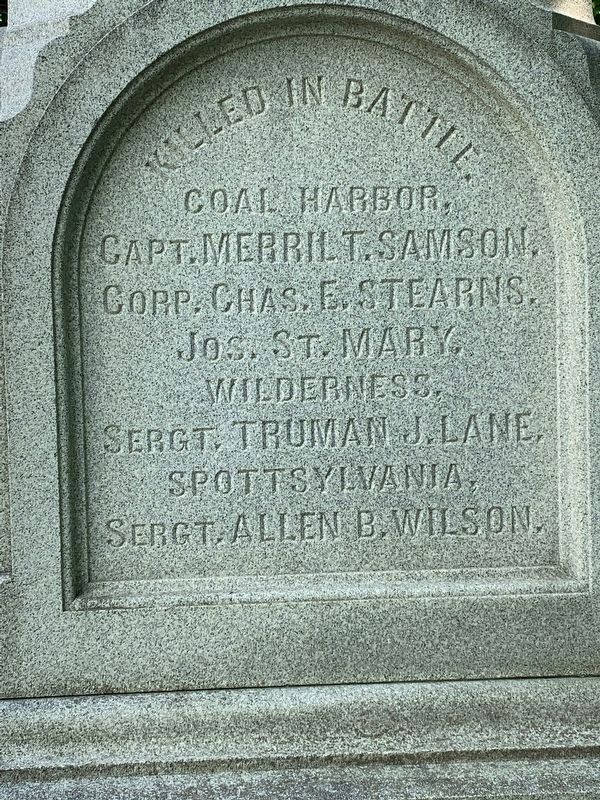
On Vermont Route 30 at Fisher Street, on the right when traveling south on Vermont Route 30.
South Side inscription:
Died in Hospital:
Sergt. Romeo R. Peck
Nelson Baxter
Loyal Darling
Adams H. Potter
Emerson Mayo Ja's E. Fenton
Hung by Guerillas
Alva K. Barlow
North and West side inscriptions . . . — — Map (db m136370) WM
On Seth Warner Memorial Highway, on the right when traveling north.
William Slade was one of Vermont’s great public servants and an ardent abolitionist. Born when Vermont was an independent republic, he died just before the Civil War.
A graduate of Middlebury College admitted to the bar in 1810, Slade was a . . . — — Map (db m135841) HM
Near Main Street (State Highway 30) 0.1 miles south of Seymour Street, on the right when traveling south.
Vermont is crossed by a complete system of ancient major routes from the Lake Champlain Valley to the Connecticut River Valley leading eventually to the sea. Paths were first made by migrating herds of animals searching for salt, and later by . . . — — Map (db m294650) HM
On Court Street (U.S. 7) at Creek Road, on the right when traveling south on Court Street.
Born in Middlebury on October 4, 1887, Ray Lyle Fisher grew up on farms along Otter Creek and Creek Road. Ray starred in baseball and football at Middlebury High School and Middlebury College before joining the New York Yankees in 1910. He pitched . . . — — Map (db m294651) HM
On North Pleasant Street (U.S. 7) at Main Street, on the right when traveling north on North Pleasant Street.
In this house, the home of
Samuel Miller, Esq. September 30, 1798 Timothy Dwight, President of Yale College, counseled with Gamaliel Painter and other citizens of Middlebury concerning the founding of Middlebury College. This conference led . . . — — Map (db m294653) HM
Near North Pleasant Street (U.S. 7) north of High Street, on the right when traveling north.
Today
Mountain bikers, hikers, runners, and nature lovers enjoy the approximately 132 acres and five miles of trails that weave through Chipman Hill. The Middlebury Area Land Trust's Trail Around Middlebury (TAM) passes over the hill and is . . . — — Map (db m273339) HM
On Seymour Street at North Pleasant Street (U.S. 7), on the left when traveling west on Seymour Street.
The Congregational Church, shown here in a photograph from the 1870s, has long held pride of place in
downtown Middlebury. Construction of the church began in 1806 and was completed three years later at a cost
of $9,000. Designed by Lavius . . . — — Map (db m273543) HM
Near Court Square (Route 7) west of Washington Street, on the right when traveling south.
From 1796 to 1814 Court Square was the site of the first Addison County Courthouse, which also served as the seat of the Vermont Legislature (1800, 1806), and home of Middlebury’s first female academy (1800). Here in June 1804 a New York . . . — — Map (db m294654) HM
On South Main Street (Vermont Route 30) 0.1 miles north of Porter Field Road, on the right when traveling north.
Emma Hart came to Middlebury in 1807 to take charge of the Female Academy. After her marriage to Dr. John Willard, the town’s first physician, she gave the earliest collegiate instruction for women in America at a Seminary in her home, during the . . . — — Map (db m294655) HM
On Court Square (U.S. 7) at South Pleasant Street, on the left when traveling west on Court Square.
On July 13-14, 1843, in the Addison County Courthouse, Frederick Douglass and other prominent abolitionists of the New England Anti-Slavery Society launched their six-month 100 Conventions tour to generate anti-slavery sentiment in Vermont, New . . . — — Map (db m273540) HM
On Merchants Row at Main Street ( Route 30), on the right when traveling west on Merchants Row.
Prior to 2020, standing here at
Merchants Row looking north, you
would have seen the railroad trench
constructed in 1849 for the Rutland
and Burlington Railroad. This trench
cut through the western portion
of the Village Green, creating . . . — — Map (db m273538) HM
On Maple Street near Printers Alley, on the right when traveling east.
If you could dig down where you're standing, you would find marble. You can see chunks of it along the banks of the Otter Creek, where the first marble quarries in Middlebury were located. By the time the Marble Works was in operation, smaller . . . — — Map (db m273560) HM
On Main Street 0.1 miles south of Mill Street, on the right when traveling south.
John Deere learned the blacksmith trade here as an apprentice in the shop of Capt. Benjamin Lawrence from 1821 to 1825. The shop was located below this spot on Mill Street, in what is known as "Frog Hollow". In 1836 Deere removed to Grand Detour, . . . — — Map (db m294657) HM
On Main Street (Vermont Route 30) north of Merchants Row, on the left when traveling north.
Lazarus Park was created in 2021
as part of the Middlebury Bridge
& Rail Project through a unique
partnership between the Town
of Middlebury, the National Bank
of Middlebury, the Marble Works
Partnership, and the Vermont
Agency of . . . — — Map (db m273547) HM
Near Mill Street just west of Park Street, on the right when traveling west.
The Marble Works Memorial Bridge was constructed and generously donated by the Marble Works Partnership to the citizens of the town of Middlebury for their use and enjoyment.
The bridge is dedicated to the memory of the mechanics of Middlebury . . . — — Map (db m273636) HM
On Maple Street west of Printers Alley, on the right when traveling west.
The Marble Works Memorial Bridge was constructed and generously donated by the Marble Works Partnership to the citizens of the town of Middlebury for their use and enjoyment.
The bridge is dedicated to the memory of the mechanics of Middlebury . . . — — Map (db m273637) HM
On Main Street (Vermont Route 30) at Seymour Street, on the right when traveling south on Main Street.
Built in 1816-1817
by Horito Seymour L.L.D.
(1778-1857) as his residence
Given February 9, 1938 by his great
granddaughter Jessica Stewart Swift
and great grandson Philip Battell Stewart
for the use and benefit of the
people of the . . . — — Map (db m273545) HM
On Maple Street west of Printers Alley, on the right when traveling east.
Otter Creek flows north for 112 miles, from Peru, Vermont, to Lake Champlain in Ferrisburgh. For thousands of years, it provided fresh water, food and transportation for the native Abenaki, who ate its fish and farmed on its shores. French trappers . . . — — Map (db m273585) HM
On Maple Street at Printers Alley, on the left when traveling west on Maple Street.
Mill Street, on the opposite bank, has run through Frog Hollow since the early days, but the "hollows" were not created until tons of beautiful gray-veined white marble were quarried from here. Starting in 1802—long before the Marble Works were . . . — — Map (db m273573) HM
Near Court Street (U.S. 7) at Court Square, on the left when traveling west.
Middlebury
In The
1861—Civil War—1865
Joseph Alexander • Henry W. Bennett • Merrill Bentley
Bertrand W. Billings • John Brunelle • Michael Burke
John Caffrey • Roderick A. Champlin • Olney A. Comstock . . . — — Map (db m294659) WM
On Maple Street at Printers Alley, on the right when traveling east on Maple Street.
If you were standing here in the 1800s, you would be deafened by the noise and surprised by the activity as burly workers and pious mill girls made their livings on the banks of Otter Creek. Middlebury Falls provided the waterpower to make the new . . . — — Map (db m273581) HM
On Maple Street west of Printers Alley, on the right when traveling west.
The Brandon Italian Marble Company became the largest firm in Middlebury, employing 175 men by 1904. In 1910 just over half of the workers were born in America, while the rest were Italian, French Canadian, Irish, Hungarian, Swedish and Russian. . . . — — Map (db m273558) HM
On Main Street (Vermont Route 30) north of Merchants Row, on the left when traveling south.
The Middlebury Village Green was
established around 1790 on land
donated by village co-founder,
Gamaliel Painter. In 1849, the
construction of the Rutland and
Burlington Railroad through Middlebury
resulted in the truncation of the
Village . . . — — Map (db m273434) HM
On North Pleasant Street (U.S. 7) at Main Street, on the right when traveling north on North Pleasant Street.
In this house, the home of Samuel Miller, Esq., Timothy Dwight, president of Yale College, counseled with Gamaliel Painter and other citizens of Middlebury concerning the founding of Middlebury College.
This conference led to the granting of . . . — — Map (db m294660) HM
On Main Street (Route 30) at College Street, on the right when traveling south on Main Street.
(Plaque)
The bench is presented by the
MHS/MUHS Alumni Association in 2016
to sit and remember
Site of Middlebury High School
Educating students
1911 to 1957
(panel next to the marker)
Middlebury High School (MHS), . . . — — Map (db m273425) HM
On Maple Street at Printers Alley, on the right when traveling east on Maple Street.
Middlebury Falls was a great source of power, but it was also an impediment to transportation, preventing the movement of goods and customers. The first Middlebury settlers could only cross the Creek on "Hop" Johnson's ferry. In 1787, mill owner . . . — — Map (db m273564) HM
Near Vermont Route 125 east of Old Chapel Road, on the left when traveling west.
Made possible through the generosity of David G. Storrs '81 in honor of Seth Storrs, a founder of both the town of Middlebury and its college. Storrs gave the land on which stand Painter Hall, Old Chapel and Starr Hall - "Old Stone Row" - as well . . . — — Map (db m246607) HM
On Court Street (U.S. 7) near Washington Street, in the median.
In 1792, the Vermont Legislature ensured Middlebury’s future prominence by choosing it as the site for Addison County courts. Three courthouses have been built in this area. The original clapboard courthouse shown on the right in the photograph, . . . — — Map (db m294661) HM
On Main Street at Merchants Row, on the left when traveling south on Main Street.
Built from the Ashes
Middlebury's Main Street has been the commercial center of the town since its founding, but its character has changed many times, largely due to that great public enemy of the era-fire. In the first half of the 19th . . . — — Map (db m294662) HM
On Main Street (Vermont Route 30) at Printers Alley, on the right when traveling south on Main Street.
Commemorating the pivotal role of
Robert J. Duclos in the acquisition
and renovation of this historic
Middlebury landmark and his 54
years of outstanding service as
cashier and president of the
National Bank of Middlebury upon
his retirement . . . — — Map (db m273891) HM
On Cross Street at Main Street ( Route 30), on the right when traveling west on Cross Street.
The Shire Town
Middlebury was chartered in 1761 as one of New Hampshire Governor Benning Wentworth’s land grants. The first settlers claimed land in the town in 1766, but were forced back to southern New England during the Revolutionary War. . . . — — Map (db m294664) HM
On Vermont Route 125 west of North Branch Road, on the right when traveling east.
This iron furnace or "bloomery" was built in 1831. The mill operated three forges and produced about three tons of wrought iron per day. During the Civil War years (1861-1865) the mill produced over 2,100 tons of iron. When it closed in 1890 this . . . — — Map (db m274134) HM
On Mill Street west of Route 30, on the right when traveling west.
For 3 Centuries The Middlebury Falls Powered A Bustling Mill District
First Came Waterwheels...
A waterwheel is a machine for extracting power directly from the flow of water. Waterwheels
have been in use for centuries. The most . . . — — Map (db m246606) HM
On Weybridge Road at Quaker Village Road, on the right when traveling north on Weybridge Road.
Charity Bryant (1777-1851) and Sylvia Drake (1784-
1868) met in 1807 in Weybridge, where they lived
and were accepted as a couple. They had a
cottage on Hagar farm. joined the local
church and charities, and ran a tailoring business.
Charity's . . . — — Map (db m305701) HM
On Weybridge Road (Vermont Route 23) south of Thompson Hill Road, on the left when traveling south.
(south side) Weybridge was chartered by N.H. in 1761 and settled in 1775 by Thomas Sandford, David Stow, Justus Sturdevant & Claudius Britell.
Nov. 8, 1778, a party of British Torries & Indians destroyed their houses and effects & . . . — — Map (db m262501) HM WM
On Weybridge Road (Vermont Route 23) at James Road, on the right when traveling south on Weybridge Road.
Born at Amherst, Mass., Silas Wright came to Weybridge as an infant and grew up here. Graduated from Middlebury College in 1815, he studied Law at Sandy Hill, N.Y.; began Law practice at Canton, N.Y. in 1819, and entered politics there. A Brigadier . . . — — Map (db m77967) HM
The U.S. Government established a Morgan horse breeding program in 1905 at the University of Vermont to study and refine the Morgan horse as a superior cavalry mount. That program moved here in 1907 when Joseph Battell donated this farm to the U.S. . . . — — Map (db m77965) HM
On Theodore Roosevelt Highway (U.S. 2), on the right when traveling east.
1917 World War I 1918
Bemis Carl •
Buik David •
Gregory Frank •
Guyette Arlie •
Larned Charles •
Larned Daniel •
Latullipe Louis •
May George •
Morgan Ralph •
Sweeney Wesley •
Tomlinson Edward •
Thompson George •
Streeter Robert . . . — — Map (db m294503) HM
On Vermont Route 2, on the left when traveling east.
“Footpath in the Wilderness” extends length of state. This 261 – mile hiker’s trail, built by the Green Mountain club during the years 1910-29, extends along the mountain summits from the Mass. State line to the Canadian border. Convenient shelters . . . — — Map (db m151129) HM
Near Church Street 0.1 miles north of College Street, on the right when traveling south.
This may be one of the oldest buildings surviving on
Church Street, possibly built in the 1820s and hidden
behind a modern façade applied in the 1980s. Here,
the famous jewelry firm of Pangorn and Brinsmaid was
formed in 1832. Brinsmaid, who . . . — — Map (db m117838) HM
On Saint Paul Street at King Street, on the left when traveling north on Saint Paul Street.
This distinctive building is probably a c.1925 remodeling of an early 19th-century, Federal Style building. Throughout the 19th century, the building was a private residence, and by the turn of the century, it was run as a boarding house. In . . . — — Map (db m246220) HM
Near Park Street (Vermont Route 127) at Sherman Street, on the right when traveling south.
On June 24, 1861, the first Vermont soldiers who enlisted for service in the Civil War for three years left Burlington for Washington by rail. Four days earlier, the 866 officers and men from across the state had been mustered into the Union Army . . . — — Map (db m75584) HM
Arahmi
"A place where I would like to be," from the language of the people of the
dawn who lived in harmony in this area for 10,000 or more years, the real
discoverers and explorers of Vermont.
This building was rebuilt from the spirit of . . . — — Map (db m118593) HM
Here in June 1813, a Vermonter, Lieut. Churchill, and men built a parapet and set up a battery. On Aug. 3 a British gunboat and 2 sloops, 1½ miles offshore, began a cannonade. This attack was repulsed in 20 minutes by the American Battery and . . . — — Map (db m75582) HM
On College Street at St. Paul Street, on the right when traveling east on College Street.
Erected by Stannard Womans Relief Corps in memory of our soldier and sailor dead 1861-1865. In honor of the brave men who victoriously defended the Union on land and sea during the war of the great rebellion. — — Map (db m89144) WM
On College Street west of Lake Street, on the right when traveling west.
Burlington Waterfront Park and Promenade
A Joint Effort Between the Citizens of Burlington, State of
Vermont, and the Central Vermont Railroad
This park was built by the City of Burlington Parks and Recreation Department, on property . . . — — Map (db m258613) HM
Near Park Street at Sherman Street, on the left when traveling north.
Between June of 1812 and June of 1815, Burlington’s War of 1812 military cantonment stood in this vicinity. Its structures included a guardhouse, stables, barracks, carpenters’ and blacksmiths’ shops, a large general hospital, officers quarters, . . . — — Map (db m200487) HM
On St. Paul Street north of Main Street (U.S. 2), on the right when traveling north.
In this park on July 22, 1863, Vermont's only ethnic Civil War unit was welcomed home from the battle of Gettysburg. Lonergan commanded Co. A, 13th VT Regiment - the Irish Company - and he received the Medal of Honor for gallantry in the battle. . . . — — Map (db m88639) HM
On College Street at Lake Street, on the right when traveling west on College Street.
In July 1609, Samuel de Champlain became the first European to set eyes on Lake Champlain. Three hundred years later, in July of 1909, communities around Lake Champlain celebrated the tercentenial of Champlain's expedition. Burlington marked the . . . — — Map (db m91649) HM
On Church Street south of College Street, on the right when traveling south.
This Beaux Arts-style building, with its symmetrical marble facades, prominent cornices, sculptural ancient Greek and Roman details, and arched windows and doors, was designed by famed Boston architects Harper & West at the request of the . . . — — Map (db m93055) HM
On Main Street (U.S. 2) at Church Street, on the right when traveling west on Main Street.
Had you stood at this location in the early 1800s, you would have had to lift your skirt off the dirt lane to step up onto the plank sidewalk or guard your hat from the danger of low wooden canopies. Pedestrians competed with horse and carriage on . . . — — Map (db m23579) HM
Near Main Street (U.S. 2) east of St. Paul Street when traveling west.
In 1797, a city planned grid system was laid out for Burlington, incorporating the few transportation routes that existed, including King, Pearl, Church and Battery Streets. At the city’s center, space was reserved for a park (now City Hall Park) . . . — — Map (db m23580) HM
On Penny Lane at Lake Street when traveling east on Penny Lane.
Electricity first came to Burlington in 1885 and was
supplied by a private generating facility on the
Winooski River. In 1905 the Burlington Electric
Department built the first municipal electric plant.
By the 1950s. more power was needed to . . . — — Map (db m290052) HM
On Main Street at Church Street, on the right when traveling west on Main Street.
This impressive Italianate-style commercial building with a massive five-foot tall cast iron cornice was historically known as the Exchange Block. Designed by local builder William Townsend, the building was intended to stylistically complement the . . . — — Map (db m209095) HM
On Cherry Street at St. Paul Street, on the right when traveling west on Cherry Street.
Imagine yourself back in time...
As you walk up the steps into the Cathedral of the Immaculate Conception you are awed by the Gothic building's vaulted ceilings, soaring stained glass windows, marble altars, gilded tabernacles and . . . — — Map (db m200489) HM
On Lake Street 0.2 miles north of College Street, on the left when traveling north.
First International
Ice Hockey Game
In February 1886 the Burlington Coasting Club hosted a week-long Carnival of Winter Sports. In addition to parades and concerts, activities included coasting (bobsledding), ice skating, and snowshoe races. . . . — — Map (db m151137) HM
On St. Paul Street at College Street, on the right when traveling north on St. Paul Street.
In 1983, a group of lesbian feminists began planning for the first Vermont Pride march to be held in Burlington and invited the gay male community to join. At the time, public celebration of pride in Vermont was controversial. Vermonters attended . . . — — Map (db m276668) HM
On Church Street at College Street, on the right when traveling north on Church Street.
Howard Bank Building
1902 ---------
This granite-faced brick building, designed and built
by Hiram Salls, is a fine example of Renaissance Revival
Classicism. Constructed for the Howard National Bank
it replaced a smaller, c.1867 bank . . . — — Map (db m118014) HM
On Battery Street at Cherry Street, on the right when traveling south on Battery Street.
Beginning in the early 1900s, the area directly to the east housed numerous emigrants. Many moved here from Italy with hopes to build better lives. Some worked in the lumber mills and railroad yards that bordered the lake. In the process, they . . . — — Map (db m75562) HM
On Church Street at Pearl Street, on the left when traveling north on Church Street.
The corner stone of the Masonic Temple was laid in an elaborate ceremony on October 20, 1897. The building was constructed for approximately $80,000 and was designed by John McArthur Harris of Wilson Brothers and Company, an architectural and . . . — — Map (db m200484) HM
Near Park Street at Sherman Street, on the left when traveling north.
"Burlington, a city of beauty, energy and hospitality" - Francis Cain, June 2017
Francis J. Cain served as Mayor of Burlington for three terms from 1965-1971.
"Mayor Cain is an honest and realistic executive who perhaps has accomplished more . . . — — Map (db m200488) HM
On Battery Street at Cherry Street, on the right when traveling north on Battery Street.
Imagine yourself back in time...
As you enter the corner grocery store, your senses are captivated by the aroma of the Italian cheeses- the provolone hanging from the
ceiling, the freshly grated Romano,
the feta and the gorgonzola. . . . — — Map (db m118736) HM
On College Street at Lake Street, on the right when traveling west on College Street.
During July 2009, the City of Burlington staged a 13-day International Waterfront Festival to celebrate the 400th anniversary of Samuel de Champlain's bold expedition into the lake that today bears his name. The festival included artists, diplomats, . . . — — Map (db m91614) HM
Near Park Street south of Sherman Street, on the right when traveling south.
The Revolutionary War (1775-1783) was our nation's fight for independence from Great Britain to establish a new country with a government based on equality, justice, and humanity. Patriots from all corners of what would become the State of . . . — — Map (db m261849) HM WM
Original home of Ben & Jerry's Ice Cream Founded May 5, 1978 Placed in commemoration of their Tenth Anniversary Celebration June 4, 1988 — — Map (db m89108) HM
Near Park Street at Pearl Street, on the left when traveling north.
Brevet Major General U.S. Vols.
1837-1892
First Lieut. Co. C 1st Vermont Cavalry Oct. 14 1861
Captain Co. C Nov. 18 1861
Major Dec. 30 1862
Colonel July 2 1864
Brevet Brigadier General U.S. Vols. Feb. 22 1865
Brevet Major General U.S. . . . — — Map (db m75579) HM WM
Near Colchester Avenue 0.3 miles east of East Avenue.
The mortal remains of Ethan Allen, Vermont leader, fighter, writer and philosopher, lie in this cemetery beneath the marble statue, but his spirit is in Vermont now. — — Map (db m51646) HM
On University Road 0.1 miles south of Colchester Avenue, on the right when traveling north.
Named to commemorate the 100th anniversary of the University of Vermont’s first graduating class, Centennial Field has been the home of UVM athletics since 1906. The three ballparks that have stood on this site have hosted semi-professional and . . . — — Map (db m307277) HM
On Main Street (U.S. 2) at St. Paul Street, on the right when traveling east on Main Street.
Presidents Monroe, Van Buren, Pierce, Grant, Generals Scott, Wool, Hampton, Henry Clay, and other famous famous people entertained here. — — Map (db m302022) HM
On North Avenue at Ethan Allen Parkway, on the right when traveling north on North Avenue.
Putting behind him the martial deeds of a hero, Ethan came here in 1787 to till the soil as a peaceful farmer. On Feb. 12, 1789, he died here after a trip across the ice to South Hero. Memorial Tower was built on Indian Rock, traditional Algonquin . . . — — Map (db m75585) HM
A century ago, most of this area was rural, but people were beginning to build houses here. William Van Patten owned many acres of land locally, and he wanted a park in this new neighborhood. He got on his old horse, Mattie, and let her find easy . . . — — Map (db m89149) HM
In 1808, the Federal government, reacting to unfair British policies, passed an Embargo Act, forbidding trade with Great Britain. The Champlain Valley relied on trade with British Canada and the Act was unpopular and significant smuggling . . . — — Map (db m98393) HM
On Riverside Avenue (U.S. 2) at Intervale Road, on the right when traveling west on Riverside Avenue.
Located on the streetcar line between Burlington and Winooski, Athletic Park was the home of the University of Vermont's baseball and football teams and track-and-field events from 1887 until Centennial Field opened in 1906. It was also where . . . — — Map (db m75483) HM
On Sherman Street near Park Street, on the right when traveling east.
The Champlain Glass Company, established in 1827,
was the first manufacturing enterprise in Burlington.
The company, located between N. Champlain and
Park (Water) streets, produced and shipped window
glass locally and to the west by the Erie . . . — — Map (db m261847) HM
On Park Street at Sherman Street, on the left when traveling north on Park Street. Reported permanently removed.
Abenaki Legend holds that Odzihozo, the creator of the Champlain Valley, turned himself into a rock island, which can be seen through the bandshell window to your left, so that he might view the valley forever.
This statue honors Chief Grey . . . — — Map (db m290057) HM
On Pearl Street at Church Street, on the right when traveling east on Pearl Street.
In 1962 architecture student Bill Truex experienced the transformation of Stroget, Copenhagen's main shopping area from traffic-snarled nightmare to successful pedestrian mall. Seven years later, while on the Burlington Planning Commission, Truex . . . — — Map (db m89110) HM
On Pearl Street at Church Street, on the right when traveling west on Pearl Street.
Designed by noted architect Peter Banner of Boston, the Federal-style Meeting House was built in 1816 for the First Congregational Society (Unitarian) and is the oldest surviving place of worship in Burlington. Banner's design features a projecting . . . — — Map (db m97755) HM
Near Archibald Street east of North Willard Street (U.S. 2), on the left when traveling east.
In memory of
John Lonergan
a native of Ireland,
who having made
the United States
his adopted country,
defended it in the
Civil War, and at the
Battle of Gettysburg
with distinction as
Capt. Co. A, 13th VT Reg't.,
and was . . . — — Map (db m143257) HM WM
On North Prospect Street 0.2 miles south of Riverside Avenue (U.S. 2), on the right when traveling south.
Mary Fletcher, born in Jericho, Vt., moved here with her family at age 20. Following her father’s death, the family established Fletcher Free Library (1873). Mary Fletcher continued her parents’ benefactions. She founded Mary Fletcher Hospital . . . — — Map (db m75501) HM
On Pearl Street at Saint Paul Street, on the right when traveling west on Pearl Street.
Imagine yourself back in time...
If you were standing here in 1959, you would see a neighborhood that included
a Catholic Cathedral, grammar and high
schools and many small businesses such as gas stations, auto dealers and boat companies, . . . — — Map (db m118840) HM
On Archibald Street east of Intervale Avenue, on the left when traveling east.
Pate-King House. The Pate-King family lived here for 67 years, opening their home as a hotel and apartment. Cleta Pate (1874-1957) was born in the Philippines, where she married Buffalo Soldier William King. In 1910, the family moved to . . . — — Map (db m261846) HM
The battery of thirteen guns on this ground repulsed an attack of three British gunboats June 13 1813
It was the defense of Burlington and of the United States Army here encamped during the War of 1812 — — Map (db m75564) HM WM
"We consider it criminal in the sight of God and man, longer silently to submit to our indignities, or suffer them to be transmitted to posterity." Andrew Harris was one of the first African Americans to earn a college degree. The antislavery . . . — — Map (db m97754) HM
On Main Street at Church Street, on the right when traveling east on Main Street.
This building was the site of the former federal building in Burlington completed in 1910. The building and land were donated in 1974 to Chittenden County for renovation to a new county courthouse.
The building served as U.S. Army Reserve . . . — — Map (db m290055) HM
On Main Street at Church Street, on the right when traveling west on Main Street.
In 1962 architecture student Bill Truex experienced the transformation of Stroget, Copenhagen's main shopping area from traffic-snarled nightmare to successful pedestrian mall. Seven years later, while on the Burlington Planning Commission, Truex . . . — — Map (db m89112) HM
Perkins Pier was named for Dr. Charles N. Perkins, a Burlington
physician for over 50 years. Dr. Perkins was born in Burlington
on May 25. 1880, and died in Burlington on June 15. 1959. Dr.
Perkins was a general practitioner, spending his entire . . . — — Map (db m178344) HM
On South Willard Street (U.S. 7) at Main Street (U.S. 2), on the right when traveling north on South Willard Street.
General William Wells (1837-1892) In 1861 William Wells joined the First Vermont Cavalry as a Private and rose to the rank of Brevet Major-General. Promoted more times than any other Vermonter during the American Civil War, he participated in . . . — — Map (db m75549) HM
On College Street, on the left when traveling north.
George Dewey, Admiral of the Navy, U.S.N.
1837-1917
Born in Montpelier, Vermont, George Dewey graduated from the United States Naval Academy in 1858. Following service in the Civil War, he held several high-ranking administrative positions in the . . . — — Map (db m115266) HM WM
On Maple Street 0.1 miles west of South Willard Street (U.S. 7), on the right when traveling west.
On Oct. 4, 1905, at 2:30 p.m. in front of the bay window in the parlor of this house, Grace Goodhue married Calvin Coolidge of Plymouth Notch, VT. Calvin Coolidge became President of the United States and Grace served as First Lady from 1923-1929. . . . — — Map (db m75591) HM
On Summit Street at Main Street (U.S. 2), on the right when traveling south on Summit Street.
This property
Grasse Mount
has been placed on the
National Register
of Historic Places
by the United States
Department of the Interior — — Map (db m261852) HM
On Main Street at St Paul Street, on the left when traveling west on Main Street.
The Green Mountain Club was born at a meeting of Vermont hiking enthusiasts in the Van Ness House hotel, which stood on this site from 1870 until it burned in 1951. The club's mission is to "make the Vermont mountains play a larger part in the life . . . — — Map (db m200490) HM
218 entries matched your criteria. The first 100 are listed above. Next 100 ⊳