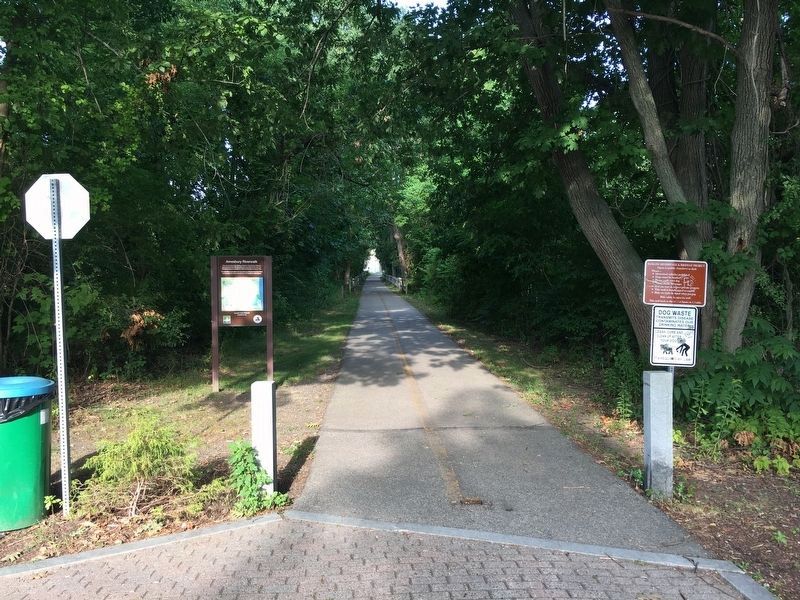
On Rocky Hill Road north of Macy Road (Massachusetts Route 110), on the left when traveling north.
This rail trail follows the Salisbury branch of the Eastern Railroad that connected the mills along the Powwow River to the main line. The branch started operation in 1848 and the last train rain in 1965.
The trail offers a peaceful multi-use . . . — — Map (db m205045) HM
Thomas Macy, first town clerk of Amesbury, erected this house prior to 1654. Persecuted for harboring Quakers he sold the house and fled to Nantucket, becoming the first white settler as related in Whittier's poem "The Exiles." — — Map (db m48772) HM
On Cabot Street (Massachusetts Route 1A) at Balch Street, on the right when traveling south on Cabot Street.
Built in 1638 by John Balch, who came over in 1623 with Captain Robert Gorges. The "Old Planters" received this land in exchange for their settlement at Salem. — — Map (db m47949) HM
On Rantoul Street (Massachusetts Route 1A) at Broadway, on the right when traveling south on Rantoul Street.
Korean War
1950 – 1953
Dedicated to Honor the Sacrifice of Our
Servicemen and Women of Beverly Who
Served and Those Who Gave Their Lives.
"For Those Who Have Had to Fight For It,
Life Has a Flavor the Protected
Will Never Know." . . . — — Map (db m36463) WM
On Rantoul Street (Massachusetts Route 1A) at Broadway, on the right when traveling south on Rantoul Street.
Vietnam War Memorial
The Citizens of Beverly Dedicate This
Memorial to All Her Men and Women Who
Served America in the Vietnam War. We
Honor the Courage and Sacrifice of Those
Who Fought and Died. We Remember Them
For Their Bravery and . . . — — Map (db m36462) HM
On Rantoul Street (Massachusetts Route 1A) at Broadway, on the right when traveling south on Rantoul Street.
World War I Memorial
Beverly Remembers With Pride
Her Sons and Daughters Who
Served Their Country in World War I.
The Glorious Ones Who Died Gave
Their Lives As a Sacrifice For
The Cause of peace. They Fought
For Us; For Us They Fell. . . . — — Map (db m36461) HM
On Rantoul Street (Massachusetts Route 1A) at Broadway, on the right when traveling south on Rantoul Street.
World War II Memorial
The Citizens of Beverly Dedicate
This Memorial To
All Beverly Men and Women
Who Served in America's
Armed Forces in World War II
Thus Becoming "Veterans".
Beverly Honors With Heartfelt
Love and Deep Sense Of . . . — — Map (db m36459) HM
On Cabot Street, on the right when traveling south.
Roger Conant was a prudent and religious man who led the old planters from Gloucester
to Salem in 1626, and held them together until the Bay Colony was founded. This house was
built on land given by him to his son Exercise Conant in 1666. — — Map (db m47357) HM
This house was built in 1694 by the Rev. John Hale, first minister of the first church in Beverly. A charge of witchcraft made against his wife convinced the minister of the folly and wickedness of the crusade and ended all witch-hunting in . . . — — Map (db m48760) HM
On Bay View Road 0.2 miles south of Neptune Street, on the right when traveling north.
[Bottom (larger) Marker]
Hospital Point Light was established in 1871 and marks the deep-water channel to Beverly, Salem, and Marblehead.
A smallpox hospital once stood on the hill to the rear, where there is also evidence of ramparts . . . — — Map (db m21441) HM
On Bay View Road 0.2 miles south of Neptune Street, on the right when traveling north.
Hospital Point Light was constructed and first lighted in 1872 to help guide vessels into Salem and Beverly Harbors. The original two-story keeper's house and oil house are still being used.
The name Hospital Point stems from a smallpox . . . — — Map (db m21429) HM
This hand-cut granite millstone is from
the tide-powered Friend's Mill. Before
burning in 1889, the mill and dam stood
on the Bass River, 200 yards south of
this spot, where Elliott Street is today.
The stone was recovered in 1903, . . . — — Map (db m263791) HM
The old planters, Roger
Conant, John Woodbery and
John Balch used this path
from their homesteads to the
cove at the head of Bass river. — — Map (db m47401) HM
On Hale Street near Bancroft Avenue, on the right when traveling north.
Beverly's first minister played a
major role during the Salem witchcraft trials of 1692. In this house he
penned the classic study of the Salem
trials -"A Modest Inquiry into the
Nature of Witchcraft" — — Map (db m162189) HM
On Cabot Street (Massachusetts Route 1A) at Roosevelt Avenue, on the right when traveling south on Cabot Street.
Roger Conant
Leader of the Old Planters
And Founder in 1626
Of Naumkeag (Salem)
Built His House Here in 1636
In the Southern Angle Of
A Two Hundred Acre Grant
He Lived Here Until His Death
November 19, 1679
Erected by the Roger . . . — — Map (db m36444) HM
On Rantoul Street (Massachusetts Route 1A) at Broadway, on the right when traveling south on Rantoul Street.
The Memorial Bell
The Very Generous Gift Of
Mr. Robert Hagopian of Hamilton
To be Used at Beverly Memorial Day
And Veterans' Day Observances
In This Park to Honor All Those
Who Sacrificed Their Lives
For Our Great Country
May God . . . — — Map (db m36458) HM
On Ingersoll St just north of Centre Street, on the right when traveling north.
In grateful memory of the following men of the town of Danvers, as well as those others whose memory is known but to God, who gave their lives and, through their sacrifice, begat us a nation.
Patrick Carroll d. Sept. 10, 1779
Samuel Cook Jr. . . . — — Map (db m309596) WM
On Water Street, on the left when traveling north.
From 1632-1754 a few farms and native American habitations dotted the woodlands among this land originally granted to pioneer settlers Gov. John Endecott and Rev. Samuel Skelton. On the road to Salem lay the farm of George Jacobs, Sr., a victim . . . — — Map (db m43938) HM
Near Forest Street at Glen Magna Road, on the right when traveling south.
Derby Summer House has been designated a registered National Historic Landmark under the provisions of the historic sites act of august 21, 1935. This site possesses exceptional value in commemorating or illustrating the history of the United . . . — — Map (db m269961) HM
Near Conant Street at Conant Street & High Street ( Route 35).
One of the most strategic and daring exploits of the patriot cause during the revolution. Part of the troops encamped in the Town of Danvers on the night of September 14, 1775 on their way to Newburyport where they embarked for the Kennebeck and . . . — — Map (db m48470) HM
Near Kirkbride Drive, on the left when traveling south.
Originally known as Hathorne Hill, a 257-foot glacial drumlin that was the
home of famous Salem Witch Trial judge John Hathorne, the land became
home of the Dodge Farm in the 1800's. However, its time as farm land was
short lived when the . . . — — Map (db m260600) HM
On High Street (Massachusetts Route 35) south of Park Street, on the right when traveling south.
Originally known as Porter's Burial
Ground, this land has been a cemetery
since the mid-18th century. Veterans of
the French & Indian War, Revolutionary
War, War of 1812, Civil War, and Spanish-
American War are among those interred
here. Two . . . — — Map (db m260599) HM
On Pine Street at Adams Street, on the left when traveling north on Pine Street.
In 1636 Francis Weston was granted this land upon which he laid out a farm. This property was purchased by Governor John Endicott in 1648, and in 1678 Francis and Rebecca Nurse moved here and built a house. In March, 1692, 71-year-old Rebecca was . . . — — Map (db m185940) HM
On Hobart Street at Forest Street, on the left when traveling west on Hobart Street.
Directly across from this site was located the original Salem Village Meeting House where civil and military meetings were held, and ministers including George Burroughs, Deodat Lawson, and Samuel Parris preached. The infamous 1692 witchcraft . . . — — Map (db m48726) HM
In 1681 the Salem village inhabitants built a home for their minister at this site. Ministers residing here were George Burroughs (1681-83), Accused in 1692 of being a witch and hanged; Deodat Lawson (1684-88), Author of the first volume about . . . — — Map (db m48720) HM
On Hobart Street at Forest Street, on the left when traveling west on Hobart Street.
In memory of those innocents who died during the Salem Village Witchcraft Hysteria of 1692 Back Monument: “I am an innocent person. I never had to do with witchcraft since I was born. I am a Gosple woman.” Martha Cory “The Lord above knows my . . . — — Map (db m48725) HM
On Centre Street at Holten Street, on the left when traveling south on Centre Street.
A fine example of chronological and architectural house development, this was the 1692 home of Sarah Holton, who gave damaging testimony against Rebecca Nurse during the witchcraft hysteria. Here during revolutionary period lived Samuel Holten . . . — — Map (db m17988) HM
On Water Street, on the left when traveling north.
Site of Israel Hutchinson's Home
—
Here were brought Danvers
Soldiers slain at the
battle of Lexington —
This memorial is a tribute to his
memory, from lineal decendants,
and the town of Danvers. —
1896
. . . — — Map (db m47197) HM
{Not all of the text on this marker can be transcribed.}
In February, 1681, the Salem village inhabitants voted, "We will build a house for the Ministry and provid convenient Land for that end. The Dementions of the House are as . . . — — Map (db m48721) HM
{Not all text on marker is transcribed here.}
In 1717 Rev. Peter Clark became minister at Salem Village. The 1681 parsonage was in poor condition, so that by the early 1730's Clark asked the inhabitants to come to a decision either to . . . — — Map (db m48722) HM
On Hobart Street at Centre Street, on the left when traveling west on Hobart Street.
To this church, rent by the witchcraft frenzy, came in 1697 the Reverend Joseph Green, aged twenty-two. He induced the mischief makers to confess, reconciled the factions, established the first public school, and became noted for his skill at . . . — — Map (db m48723) HM
On Kirkbride Drive, on the right when traveling east.
Situated on the crest of Hathorne Hill with breathtaking panoramic views extending to Boston eighteen miles to the south, this was the site of the Danvers State Hospital from 1878 until 1992.
The establishment of the “Danvers State Lunatic . . . — — Map (db m260626) HM
Near Water Street at Endecott Street. Reported missing.
One-eighth of a mile distant.
On a part of the 300 acres
granted to Governor John
Endecott, is the pear tree
planted by the Governor in
1632. This tree still bears
fruit. — — Map (db m46192) HM
Near Endicott Street at Hutchinson Drive, on the left when traveling west.
Growing on this site is the oldest
cultivated tree in America, planted ca. 1632
by John Endecott, first governor of the
Massachusetts Bay Colony. The “Endecott
Pear Tree” is a living link to the earliest
European settlers of our nation. . . . — — Map (db m260593) HM
On Kirkbride Drive, on the right when traveling east.
[Left panel, clockwise from top left]
• 1878 engraving of the newly constructed hospital.
• An enclosed sunporch added to the front of the brick exterior of the wings in 1921.
• An intricately designed flower garden laid out at the . . . — — Map (db m260613) HM
On Kirkbride Drive, on the right when traveling east.
[Left panel, clockwise from top left]
• Five hospital Trustees and administrative staff, including Dr. Julia K. Casey, stand on the steps of the Central Administrative Building this this 1880s formal photograph.
• A class of attentive . . . — — Map (db m260618) HM
On Maple Street near Central Ave, on the right when traveling north.
Called "Porter's Plain" after 17th century settler
John Porter, this level expanse of about one square
mile was sparsely inhabited into the mid-18th century.By the time of the American Revolution, patriot
Captain Jeremiah Page had settled here, . . . — — Map (db m38341) HM
On Centre Street, on the right when traveling west.
Defense was a prime necessity to the early settlers of Salem Village, and as early as 1671 the male inhabitants began meeting here for military drill. This preparation was heightened in 1675 during the King Philip War in which many villagers took . . . — — Map (db m17991) HM
Near Martin Street (Massachusetts Route 22) at Shepard Drive.
To the 186 loyal sons of Essex
1861 who fought for the Union. 1865
Erected through the efforts of W.R.C. No. 114.
Antietam • Wilderness • Cedar Creek
Appomattox • Ressaca • Port Hudson • Gettysburg
New Orleans • Mobile • Fort . . . — — Map (db m97211) WM
A free school for Chebacco
parish was opened in an
upper room of this house in
1695 by the appointed master,
Nathaniel Rust, Junior. The town
gave "Six acres of pasture land
for the benefit of the school
and one-quarter acre for
Mr. Rust's . . . — — Map (db m47496) HM
On Martin Street (Massachusetts Route 22) at Shephard Drive, on the left when traveling east on Martin Street.
In memory of Herbert Goodhue who died in the service of his country Born June 15, 1914 Died May 13, 1942 In the Philippine Islands Dedicated May 30 1949 — — Map (db m97209) WM
On John Wise Avenue (Massachusetts Route 133), on the right when traveling north.
Erected in 1701 by John Wise, pastor of the Chebacco parish of Ipswich, now Essex. Son of a laborer, Harvard graduate, army chaplain, protestant against taxation without representation and against the witchcraft delusion, defender of democracy in . . . — — Map (db m47955) HM
Sp4 Paul D. Knowlton HHC 4 Trans. Co June 2, 1947 Feb 24, 1968 PFC Robert E. Moore Com 7 Mar I Mar Div Feb 16 1948 Nov 2, 1967 To all who come to use these grounds, take a moment to remember two young boys that played on these very fields when their . . . — — Map (db m97214) WM
On Main Street (Massachusetts Route 133), on the left when traveling east.
Dedicated to the those men of Chebacco and Essex who by the skill of mind and hand within sight of this spot created nearly 4000 wooden vessels 1650-1982 — — Map (db m97208) HM
On Main Street (Massachusetts Route 133), on the right when traveling north.
In 1668 the town granted the
adjacent acre of land "To the
inhabitants of Ipswich for a yard
to build vessels and to employ
workmen for that end."
The shipbuilding industry has
continued uninterruptedly in
Essex since that date. — — Map (db m47495) HM
On John Wise Avenue (Massachusetts Route 133) at Old Essex Road, on the right when traveling north on John Wise Avenue.
From this spot, you look out to the Castle’s Neck River, a meandering seven-mile tributary that is part of the Great Marsh ecosystem. The Great Marsh is the largest salt marsh in New England and includes over 25,000 acres of spectacular coastal . . . — — Map (db m254136) HM
Near Rogers Street (Massachusetts Route 127) at Porter Street, on the right when traveling east.
From a large bark or packet ship 200 to 300 feet long, lost at sea. Salvaged by Captain Salvatore Zappa and crew of the fishing vessel Carol Ann in 1988. — — Map (db m193088) HM
On Middle Street at Washington Street, on the right when traveling east on Middle Street.
The eminent artist, Anna Vaughn Hyatt Huntington, had Gloucester roots and French ties. In 1910 when Huntington first entered a life-sized plaster of Joan of Arc into a Paris Salon competition, she found that some of the judges doubted that she . . . — — Map (db m245589) HM
On Western Avenue (Massachusetts Route 127) at Perkins Road, on the right when traveling north on Western Avenue.
Blynman Bridge
1907
In Honor Of
Richard Blynman
First Minister and Leading Citizen
Of Gloucester
Who in 1643 Dug This
Canal Uniting River and Bay
G.H.S. — — Map (db m36363) HM
Near Rogers Street (Massachusetts Route 127) east of Porter Street when traveling south.
Cape Ann lies on an outcropping composed of 450 million-year-old granite polished by glaciers. This particularly dense stone was prized for building monuments, forts, and piers. Blocks of Cape Ann granite were used to build Gloucester's Dale . . . — — Map (db m115434) HM
On this site in 1623
A company of fishermen and farmers from Dorchester England under the direction of Rev. John White founded the Massachusetts Bay Colony From that time the fisheries the oldest industry in the commonwealth has been . . . — — Map (db m85296) HM
Near Rogers Street (Massachusetts Route 127) at Hancock Street, on the right when traveling east.
The first man to sail single
handed from west to east
across the Atlantic Ocean.
A typical Banks dory decked
over, christened Centennial to
commemorate the first centennial
of the founding of the
United States, 1776 . . . — — Map (db m115475) HM
Near Rogers Street (Massachusetts Route 127) at Hancock Street, on the right when traveling east.
Citizen of Gloucester,
crossed the Atlantic twice,
alone, without any fingers
or toes and part of one foot
missing, all frozen in an
accident at sea.
On June 18, 1899, sailed from
Gloucester, Mass. To
Gloucester, England, on . . . — — Map (db m115478) HM
On Rogers Street (Massachusetts Route 127) west of Duncan Street, on the right when traveling east.
Charles Heberle (1862-1956) was sent at age 13 from Virginia to Essex, where for three years he was indentured to the Essex Tannery. Once free, he worked nearby for a dairy farmer, Caleb Cogswell.
Soon, Heberle chose waterfront over farm and . . . — — Map (db m115439) HM
On Yankee Division Highway (Massachusetts Route 128) at Washington Street ( Route 127), on the left when traveling north on Yankee Division Highway.
This Circle
Erected by The
Commonwealth
of
Massachusetts
1956
Is Dedicated to Honor
Chester H. Grant
1897 – 1954
A soldier and devoted citizen who faithfully served his community, state and nation in war and in peace.
A . . . — — Map (db m36316) HM
On Western Avenue (Massachusetts Route 127) at Middle Street, on the right when traveling north on Western Avenue.
In Honor of the Men Who Established Coast Guard Aviation
In May of 1925 On
Ten Pound Island in Gloucester Harbor
Home of the First Continuously Operating Coast Guard Air Station
Growth in Operations and Aircraft Size Forced a Move
To Salem . . . — — Map (db m36437) HM
On Harbor Loop south of Rogers Street ( Route 127), on the left when traveling south.
Born on Middle Street, business theorist and investor Roger Babson hired unemployed stone cutters to inscribe more than two-dozen boulders during the Depression. He hoped that words such as "industry," "initiative," and "integrity" would inspire . . . — — Map (db m115460) HM
On Eastern Point Boulevard 0.6 miles south of Fort Hill Avenue when traveling south.
This bell was used as the fog signal at Eastern Point Light House from June 1933 to Dec 1969.
Cast in Chelsea, MA. gold dust was sprinkled in the mold in order to obtain the right tone. — — Map (db m115484) HM
On Western Avenue (Massachusetts Route 127) at Babson Court, on the right when traveling north on Western Avenue.
For nearly four centuries the history of Gloucester has been the story of America's greatest fishing port. With this memorial we commemorate the lives and the legacy of those who died at sea while fishing.
The first settlers came from England . . . — — Map (db m156491) HM
On Western Avenue (Massachusetts Route 127) at Essex Avenue ( Route 133), on the right when traveling north on Western Avenue.
Gloucester Fisherman's Wives Memorial
Dedicated By The
Gloucester Fisherman's Wives Association
August 5, 2001
[ inscription around the base of the sculpture ]
The Wives, Mothers, Daughters and Sisters of Gloucester Fisherman . . . — — Map (db m36359) HM
On Western Avenue (Massachusetts Route 127) at Perkins Road, on the right when traveling north on Western Avenue.
[ bay side ]
In Memory Of
Korean Veterans
June 27 1950 – Jan 31 1955
Dedicated In 1980
By The Citizens Of
Gloucester
[ land side ]
In Memory Of
Vietnam Veterans
Aug 5 1964 – May 7 1975
Dedicated In . . . — — Map (db m36435) WM
On Prospect Street at Pleasant Street when traveling south on Prospect Street.
North facing, front side
G. Co. Eighth Regiment Massachusetts Infantry, U.S. Vols.
Reviewed by General Maximo Gomez
at Matanzas, Cuba, February 20, 1899
Gloucester's sons, one hundred strong
answered the nation's call to arms . . . — — Map (db m75261) WM
On Western Avenue (Route 127) at Essex Avenue ( Route 133), on the left when traveling north on Western Avenue.
[ inscribed around the base of the globe ]
We Fought For Freedom Around The World
[ plaque on central column ]
Gloucester
Remembers
1941 – World War II – 1945
The people of Gloucester proudly dedicate this . . . — — Map (db m36768) HM
On Eastern Avenue (Massachusetts Route 127) 0.5 miles south of Sheehan Terrace, on the right when traveling south.
James Babson
Farm
Granted by Special Town Act December 23, 1658
James and his mother Isabel were the first Babsons to reach America, arriving in 1632.
James' father died on shipboard while crossong.
-----------------
Town records show . . . — — Map (db m36302) HM
Near Western Avenue (Massachusetts Route 127) at Essex Avenue ( Route 133), on the right when traveling north.
[ upper plaque ]
In Memory of those who fought in the Revolutionary War with the Nathaniel Warner Company and those men and women who helped make this a free and independent nation.
Placed by the reactivated
Nathaniel Warner . . . — — Map (db m36354) HM
On Washington Street at Centennial Avenue, on the right when traveling north on Washington Street.
Welcome to Oak Grove Cemetery
The Oak Grove Cemetery was founded in 1854 by six local businessman: Benjamin Hough, Jr., Edward Babson, Epes Merchant, Frederick Norwood, Herman Davison, and Eben Stacy. The intention of the founders was to create a . . . — — Map (db m250792) HM
Here in 1630-31 a company from Plymouth, under Abraham Robinson, established a fishing station
and built curing stages. For nearly two centuries and a half Annisquam was a fishing and ship-building center. — — Map (db m48615) HM
Near Rogers Street (Massachusetts Route 127) at Hancock Street, on the right when traveling east.
Used by a 500 ton 3-masted sailing ship, 150 ft in length. Salvaged by Capt. Frank Santuccio of the Fishing Vessel Blue Waters on Nov. 22nd, 1963. — — Map (db m193089) HM
On Middle Street just west of School Street, on the right when traveling west.
Erected by Roger W. Babson in honor of his ancestor Reverend John Rogers burned at the stake February 4, 1555 in London for translating the Bible into English and preaching the Eighth Chapter of Deuteronomy. — — Map (db m243072) HM
Near Western Avenue (Massachusetts Route 127) at Essex Avenue ( Route 133), on the right when traveling north.
In memory of the soldiers and sailors and all others who rendered aid to the cause of American Independence during the Revolutionary War
Erected by Lucy Knox Chapter Daughters of the American Revolution of Gloucester
June 17, 1913 — — Map (db m36356) HM
On Washington Street (Route 127) at Hodgkins Street, on the left when traveling north on Washington Street.
[South Side of Marker]
Riverdale
Martyrs
In the War
Of the Rebellion.
1861-1865
[East Side of Marker]
Serg – Benj. H. Griffin, C. 23d Mass.
Addison Griffin, I. 23d Mass.
Abraham Day, Jr. G. 23d Mass. . . . — — Map (db m24020) HM
On Washington Street (Massachusetts Route 127) at Gee Avenue, on the right when traveling north on Washington Street.
[ front ]
Honor Roll
-----------
In Honor
Of Those
Who
Answered
Their
Country's
Call
[ plaque on back ]
Riverdale
Honors Her Sons and Daughters
Who Served
In World War II
Meyer Abrahams • Sidney Abrahams . . . — — Map (db m36441) HM
On Rogers Street (Massachusetts Route 127) at Parsons Street, on the right when traveling east on Rogers Street.
“There were no galleries in those days and no one ever expected to sell a picture, so you weren’t interested in making it. You were only interested in actually being a good artist… And, of course, you didn’t need as much money. I remember . . . — — Map (db m115465) HM
On Rogers Street (Massachusetts Route 127) at Porter Street, on the right when traveling east on Rogers Street.
“In Its heyday as a salt fish producer; Gorton's… kept dozens of wharves and acres of flake yards busy with the unloading, filleting, salting, drying, boning, cutting, grinding, smoking, boxing, packaging, and canning of the millions upon . . . — — Map (db m115459) HM
On Rocky Neck Avenue at East Main Street, on the right when traveling west on Rocky Neck Avenue.
In September, 1606, Samuel de Champlain landed at Rocky Neck in what is now Gloucester Harbor, to caulk his shallop, and made an accurate chart of the harbor which he called Le Beauport. — — Map (db m274809) HM
On Warren Street at Dale Avenue, on the right when traveling west on Warren Street.
Samuel Sawyer was a great Gloucester philanthropist. A very successful ship owner and merchant, Mr. Sawyer donated Gloucester's City Hall clock and bell. He bought up woodlots to preserve the 600-acre Ravenswood Park. He founded the City's first . . . — — Map (db m115426) HM
On Hough Avenue north of Western Avenue ( Route 127), on the right when traveling north.
On this site in 1623 the Dorchester Adventurers founded the nucleus of the Massachusetts Bay Colony, and fishing industry. Here Roger Conant averted bloodshed between two factions contending for a fishing stage, a notable example of arbitration in . . . — — Map (db m274831) HM
On Harbor Loop south of Rogers Street ( Route 127), on the right when traveling south.
"King of the Mackerel Killers"
Solomon Jacobs Landing & Park were named for Captain Solomon Jacobs, who fished in the early 1900s.
A native of Newfoundland, he was known as the "King of the Mackerel Killers" for his ability to land huge . . . — — Map (db m115472) HM
On Western Avenue (Massachusetts Route 127) at Essex Avenue ( Route 133), on the right when traveling north on Western Avenue.
Stacy Esplanade
Is the Result of a Wish Conceived By
His Parents and Fulfilled by Their Son
George O. Stacy
Keenly Alive to the Beauty Of
Gloucester Harbor
He Desired to Bring to Its Shores A
Corresponding Beauty
This Tablet is a . . . — — Map (db m36360) HM
Near Western Avenue (Massachusetts Route 127) at Essex Avenue ( Route 133), on the right when traveling north.
Oldest Defenses in the Mass. Bay Colony. Thrown up in 1625 by Capt. John Hewest. Occupied in King Philips War 1675 and in King Georges War 1743. Companies under Capt. John McCaw and Capt. John Lane stationed here during War for Independence . . . — — Map (db m36355) HM
On Western Avenue (Massachusetts Route 127) at Middle Street, on the right when traveling north on Western Avenue.
Before you stretches Ten Pound Island. In 1821 a lighthouse was built on the island to safely direct sailing ships into Gloucester Harbor. Some of America's greatest works of art were painted by Winslow Homer while staying at the keeper's house in . . . — — Map (db m36436) HM
On Washington Street (Massachusetts Route 127) at Brierwood Street, on the right when traveling north on Washington Street.
In Honor
Of Those Who Served
In World War II
From Ward Seven
These Our Dead From
Ward 7, WW II
Robert J. Hodgen A.F. • Robert W. Seppala A.F. • William Lee M.M. • John A. Filfalt M.M. • James M. Tarr M.M. • Roy M. Nickerson . . . — — Map (db m36440) HM
On 16 Fort Square near Commercial Street, on the right.
On August 8, 1775, the HMS Falcon, commanded by British Captain John Linzee, captured a schooner from Hispaniola bound for Salem. A second schooner sailing in company with the first made its escape into Gloucester Harbor. The
Falcon pursued it into . . . — — Map (db m266666) HM
On Bay Road (Alternate Massachusetts Route 1), on the right when traveling south.
On December 3, 1787, the first covered wagon to leave
Massachusetts for the west
set forth from this spot
arriving the next spring in
the northwest territory and
founding Marietta, Ohio. — — Map (db m47272) HM
On Country Road (Massachusetts Route 133) at Ward Street, on the right when traveling north on Country Road.
Among the founders and early
residents of Ipswich - 1630 -
were John Winthrop, Junior,
scientist and industrial pioneer; Nathaniel Ward, lawmaker
and wit; Richard Bellingham
and Richard Saltonstall, magistrates who defended popular
rights; . . . — — Map (db m47556) HM
On South Main Street west of County Street, on the left when traveling north.
The Alexander Knight House is a re-creation of an authentic early Ipswich timber frame house from 1567. It was built with traditional tools, materials and construction methods of the First Period (1625-1725). The plans for the house are based on . . . — — Map (db m253885) HM
On County Street north of Elm Street, on the right when traveling north.
The Lower Falls
Here at Falls Island and Sawmill Point stood some of Ipswich’s earliest mills, powered by the Lower Falls of the Ipswich River. A fulling mill built by John Whipple in 1673 was followed by hemp mills, grist mills, and saw . . . — — Map (db m254089) HM
The Brig Falconer was wrecked on Ipswich Beach December 17, 1847. Seventeen of the passengers and crew were lost. Twelve lie buried here in one common grave.
Thomas Shaw, and his wife • Julia Laskin • Margaret Hennesy • Howard Fling • Peter . . . — — Map (db m107994) HM
Gen. James Appleton born Feb 14, 1783 died Aug 25, 1863.
A Patriot, a Philanthropist and a Christian. He served his County, his Fellow men and his God by laboring for the emancipation of the American Slave. — — Map (db m107993) HM WM
On North Main Street south of Meetinghouse Green, on the right when traveling south.
In Memory of
Ipswich Soldiers and Sailors
of
the American Revolution
1775 1783
Placed by
Agawam Chapter
Daughters of the American Revolution.
1923 — — Map (db m253812) WM
On North Main Street at Meetinghouse Green, on the left when traveling north on North Main Street.
1871.
Erected by the Town of Ipswich in memory of her brave and lamented sons who gave their lives to their country in the war for union and liberty. 1861—1865
Our Patriot Dead.
Pierce L. Butler • J. W. Brown • C. P. Batchelder • . . . — — Map (db m253815) WM
On County Street at Elm Street, on the left when traveling north on County Street.
On this site stood a 1760's Georgian style house which was saved from demolition in 1963, reconstructed and exhibited within the walls of the Smithsonian Institution's National Museum of American History in Washington, D.C.
The "Ipswich . . . — — Map (db m253940) HM
378 entries matched your criteria. The first 100 are listed above. Next 100 ⊳