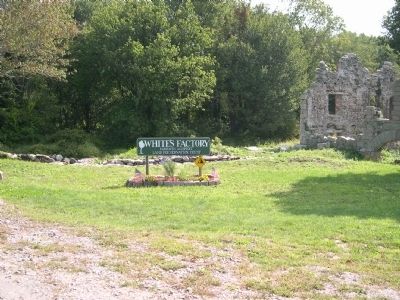
A mill dam was first built on this site in 1746. About 1799, William White, Sr. built a stone water-powered cotton mill for himself and three of his sons, Phineas, William and Benjamin. That mill, one of the earliest in the country, burned down . . . — — Map (db m16723) HM
Col. Lewis L. Millett, U.S. Army Medal of Honor, D.H.S. (Dartmouth High School) Class 1940, American Legion Post 307, Veterans of Foreign Wars Post 9059. — — Map (db m95016) WM
This memorial statue is dedicated to Medal of Honor recipient Private David Lewis Gifford Company B, 4th Regiment Massachusetts Volunteer Cavalry and all Dartmouth residents who served in the Civil War. 1861-1865. — — Map (db m95017) HM
Near Fort Street west of Beacon Street, on the right when traveling west.
In Memory of
Historian, Author, and Fire Chief
Donald R. Bernard
1932 - 1993
Who led Revolutionary and
Civil War Re-enactments on
this site. His efforts brought
awareness of the significant
role the area . . . — — Map (db m88205)
On Fort Street, on the right when traveling south.
Built for harbor defense in 1775. Destroyed by the British September 6th 1778. Later rebuilt and now the property of the town of Fairhaven. — — Map (db m52383) HM
On Fort Street west of Beacon Street, on the right when traveling west.
In May 1775, British General Gage, bottled up in Boston Harbor after the Battle of Concord and Lexington in 1775, sent the HMS Falcon to Martha's Vineyard and the Elizabeth Islands in search of food and supplies. Two of the . . . — — Map (db m86947) HM
On Fort Street west of Beacon Street, on the right when traveling west.
1775 - First naval encounter of American Revolution.
1778 - Captured and destroyed by the British.
1812 - Repelled British attempt at capture.
1861 - Manned by Federal troops in defense of this harbor. — — Map (db m88055) HM
On Fort Street west of Beacon Street, on the right when traveling west.
The fortress structures of Fort Phoenix remaining today are the parapet, built before the Civil War, and the gunpowder magazine, completed in 1865. The Civil War era officer's quarters and barracks were destroyed by fire in 1918.
The shape and . . . — — Map (db m88105) HM
On Fort Street west of Beacon Street, on the right when traveling west.
Erected in Memory of
Major Israel Fearing
the Ardent Patriot and
Accomplished Soldier
————
On the 7th day of September 1778
the British troops landed from
their ships in the bay for the . . . — — Map (db m88084) HM
Near Fort Street west of Beacon Street, on the right when traveling west.
Taken from the British at Nassau 1777, by Colonial ship of war Alfred - Placed on Fort Phoenix Recaptured by British and left on the fort spiked, and with trunions knocked off - Afterwards mounted in Union street for village defense. Placed here . . . — — Map (db m88106) HM
On Church Street east of Main Street, on the right when traveling east.
William Bradford
Marine Artist
1823-1892
Built his first studio in 1851 on this site.
The Fairhaven native achieved international fame
as a lecturer and an Arctic painter.
Queen Victoria commissioned Bradford . . . — — Map (db m86796) HM
On Western Fall River Expressway east of Water Street Connector, on the right when traveling west.
2017 - Initial talks to establish "Hortensia" - The Hydrangea Project
2018 - Established "Hortensia" The Hydrangia Project
2019 - June 25th proclaimed Hydrangea Day in City of Fall River, the Hydrangea officially . . . — — Map (db m312950) HM
Near Water Street west of Davol Street, on the right when traveling west.
16-inch guns were the US Navy's largest weapons during WWII. They were carried in groups of three on battleships like Massachusetts, and were housed in the enormous turrets that sheltered the crew and the projectiles
The gun's name . . . — — Map (db m313109) HM
Near Water Street west of Davol Street, on the right when traveling west.
Range: 10 miles
Rounds per minute: 15 (average)
Gun crew: 26 men
Lining the sides of Massachusetts are her 20 5-inch guns. Firing a 55-pound projectile, they could destroy marine surface targets . . . — — Map (db m313184) HM
Near Water Street west of Davol Street, on the right when traveling west.
Each 5-inch gun system consisted of a twin gun mount and two handling rooms below. Inside were the men, machinery, gunpowder, and projecticles required to fire a shot.
Rammer
The rammer pushed the projectile and powder case one . . . — — Map (db m313183) HM
On Western Fall River Expressway at Water Street Connector, on the right when traveling west on Western Fall River Expressway.
Matthew Chaloner Durfee (MCD) Borden (July 18, 1842 - May 27, 1912) was an American textile leader from Fall River who, in 1880 reorganized the failed American Print Works, established by Holder Borden in 1835, into the American Printing Company . . . — — Map (db m312924) HM
On Water Street, on the right when traveling west.
On the 11th of September 2001, at approximately 8:30 am, an attack began against several points in the United States. By 2:00 pm that day, both towers of the World Trade Center were destroyed. A fire was raging in a . . . — — Map (db m85866) HM WM
Near Water Street west of Davol Street, on the right when traveling west.
Explore below deck and discover the ship's workings. See her technology and what it took to make the battleship a tough warrior. Visit the engine room, the source of her power that propelled her through open ocean. Enter radio central, the main . . . — — Map (db m313103) HM
Near Water Street west of Davol Street, on the right when traveling west.
The battleship carried several smaller boats, such as this utility boat, two motor whale boats, and one boat just for the captain. They were used for duties like moving supplies and delivering mail, as well as taking sailors to ports and beaches . . . — — Map (db m313187) HM
Near Water Street west of Davol Street, on the right when traveling west.
Massachusetts was not always one color of gray. During wartime service, she carried a patterned paint scheme which used a few shades of gray and blue. After WWII she was painted a single color, which is how the ship is presented today. . . . — — Map (db m313204) HM
Near Water Street west of Davol Street, on the right when traveling west.
A battleship's crew is what gave the ship a spirit and a soul. Without them, she was nothing. They rallied for war, manned battle stations, and filled the ship with sound and energy. On this tour, see the places that wer epart of a sailor's daily . . . — — Map (db m313098) HM
On Western Fall River Expressway east of Water Street Connector, on the right when traveling west.
Gates of the City in Fall River is a replica of Portas de Cidade located in the municipality of Ponta Delgada, on the island of Sao Miguel (St. Michael), in the Azores, Portugal.
Portas de Cidade, are impressive arched gateways built in the . . . — — Map (db m312949) HM
On Weston Fall River Expressway east of Water Street Connector, on the right when traveling west.
Fall River Line (1847-1937) origins can be traced back to Colonel Richard Borden, a Fall River businessman who found his fortune in the iron and textile industries. He operated steamboats between Fall River and Providence as early as 1827. . . . — — Map (db m312947) HM
On Western Fall River Expressway at Water Street Connector, on the right when traveling west on Western Fall River Expressway.
From 1832-1860, Fall River, better known for cotton brokers than skippers, for looms than whale ships, sent 22 whalers down to the sea.
In November 1842, the Holder Borden, named for a descendent of Richard Borden and a leading manufacturer, . . . — — Map (db m312920) HM
Near Water Street west of Davol Street, on the right when traveling west.
The flag bags were storage bins for the brightly colored signal flags and pennants used to transmit messages ship to ship. From here, signalmen hoisted flags up to the yardarm to deliver a message. They had to be quick and accurate—flags in the . . . — — Map (db m313195) HM
On Water Street at Ponta Delgada Boulevard on Water Street.
These "gates" symbolize the friendship between two sister-cities
Fall River and Ponta Delgada
reaching across the Atlantic to share their cultures, their hopes and the dreams of their people.
July 22, 2006
Edward M. Lambert, Jr. . . . — — Map (db m312977) HM
Near Water Street west of Davol Street, on the right when traveling west.
Important information was passed to the officers and crew from this box, commonly known as the "1MC." An announcement might begin with a bugle or piped boatswain's call, each with its own set of melodies designed to pass information clearly and . . . — — Map (db m313199) HM
On North Main Street at brightman Street, on the right when traveling south on North Main Street.
Colonel Durfee was born in Fall Rive (then Freetown) April 27th, A.D. 1750, and died in Freetown, December 10th, A.D. 1841. He rendered distinguished service at the Battles of Long Island and White Plains, in New York, and at the Battle of Rhode . . . — — Map (db m244691) WM
Near Water Street west of Davol Street, on the right when traveling west.
Crossing over open ocean and powering onto beaches, these Landing Creaft Mechanized, or LCM, brought men and equipment to war. With a flat bottom and a ramp at the front, these vessels pulled up to the shoreline to unload. They delivered . . . — — Map (db m313075) HM
On Western Fall River Expressway east of Water Street Connector, on the right when traveling west.
Mechanics Mill is a historic, cotton, textile mill located at 1082 Davol Street in Fall River. The mill, constructed in 1868, from red brick in the Italianate style. A style derived from medieval Italian villas and farmhouses. . . . — — Map (db m312948) HM
Near Water Street west of Davol Street, on the right when traveling west.
The 20 millimeters were the last line of a battleship's air defense. With a kamikaze plane bearing down, these anti-aircraft guns wer enecessary for high-angle, close-range fire. Capable weapons, they were responsible for 48% of all downed . . . — — Map (db m313094) HM
On Ponta Delgada Boulevard east of Water Street, on the right when traveling south.
Em comemoração da visita de Sua Excelência o Presidente da República Portuguesa, Professor Doutor Anibal Cavaco Silva, às Portas da Cidade de Fall River, em 22 de Junho de 2007
To commemmorate the visit of His Excellency . . . — — Map (db m312976) HM
On Eastern Avenue at Pleasant Street, in the median on Eastern Avenue.
His explorations and scientific accomplishments dispelled the legend of the tenebrous sea, beaconed the ocean route to India and opened the gateway of the Atlantic to the American continent.
•
This monument in his honor marks the . . . — — Map (db m1617) HM
Near Water Street west of Davol Street, on the right when traveling west.
PT 617
Elco Boat, "Dragon Lady"
Built by the Elco Boat Company in Bayonne, New Jersey, PT 617 missed the opportunity to serve in WWII. It was sold as surplus and used as a diving platform in Florida . . . — — Map (db m313086) HM
Near Water Street west of Davol Street, on the right when traveling west.
Fast and furious WWII vessels
The daring PT boats gave invaluable support to the US Navy during World War II. Known as the "Mosquito Felet," their main mission was to attack enemy ships raning from small bargest to large destroyers. . . . — — Map (db m313082) HM
On County Street at Buckley Street, in the median on County Street.
Deposited on this spot during
the glacial period ages ago.
Unique in its tilting feature,
It is recognized as of great
historic and scientific interest.
Preserved by the public in the year 1930 — — Map (db m218829) HM
Near Water Street west of Davol Street, on the right when traveling west.
Used in military actions for ages, searchlights were used to locate night targets and to send coded signals. Morse code, a common language for wartime, could easily be sent by flashes of light. This was done by quickly opening and closing a . . . — — Map (db m313196) HM
Near Water Street east of Davol Street, on the right when traveling west.
The battlship's astounding firepower is the highlight of this tour. To discover it, head topside and climb up the outdoor decks of the ship. See the ship's manyguns and step inside the 16-inch and 5-inch gun mounts. Visit the places important to . . . — — Map (db m313096) HM
On Water Street west of Davol Street, on the right when traveling west.
Friends or Foes?
USS Fall River's peace-keeping duties provided sailors with a welcome respite from the drudgery of sea drills, as well as once-in-a-lifetime opportunity to sample the unique cultures of the Far East. Later, these . . . — — Map (db m313046) HM
Near Water Street west of Davol Street, on the right when traveling west.
A long-serving destroyer
A Gearing-class destroyer, USS Joseph P. Kennedy Jr. was built in Quincy, Massachusetts in 1945. She was an all-purpose ship: speedy, maneuverable, and adaptable to any task. Built in only eight . . . — — Map (db m313079) HM
Near Water Street west of Davol Street, on the right when traveling west.
A WWII fleet submarine
Built in Pennsylvania, commissioned in 1944 in New Hampshire and quickly ordered into World War II action, USS Lionfish entered Japanese waters on April 1, 1945. For five months, until the end of the . . . — — Map (db m313081) HM
Near Water Street west of Davol Street, in the median.
A WWII battleship packing firepower
"Big Mamie," as she was fondly known by the crew, has the distinct honor of firing the US Navy's first and last 16-inch shells in World War II. Built in Quincy, Massachusetts and commissioned in . . . — — Map (db m313077) HM
Near Water Street west of Davol Street, on the right when traveling west.
Length: 681 feet
That's almost the size of two football fields.
Displacement: 46,000 tons (Fully loaded)
Maximum Speed: 27 knots
Equivalent to 31 MPHHow many . . . — — Map (db m313090) HM
This 38,030 pound manganese-bronze propeller was manufactured at Philadelphia Navy Yard and was removed from Battleship Massachusetts during her 1998-1999 drydocking. It is one of four. When turning at 185 revolutions per minute, they propelled . . . — — Map (db m33075) HM
Near Water Street west of Davol Street, on the right when traveling west.
A floating city packed into a fighting machine, the battleship USS Massachusetts performed outstanding World War II wartime actions. She fought in two oceans, used her firepower to help defeat the enemy, and returnedh ome after the war . . . — — Map (db m313093) HM
On Water Street south of Anawan Street, on the right when traveling north.
Anchors (left)
Recovered from RMS Republic, a White Star Line vessel which sank 50 miles off Nantucket on January 24, 1909.
Republic collided with SS Florida in a major North Atlantic shipping lane and 270 feet of shark . . . — — Map (db m312978) HM
Near Water Street west of Davol Street, on the right when traveling west.
In a war that spanned years, many continents and the expanse of oceans, USS Massachusetts delivered constant and victorious fighting for the United States. On this tour, learn about the country's patriotic mindset and Massachusetts' . . . — — Map (db m313101) HM
Near Water Street west of Davol Street, on the right when traveling west.
World War II
The "Good" War
Seldom in the annnals of human combat has there been a stronger case made for war. With the globe still licking its wounds from the "War to End All Wars" and Great Depression, the Axis Powers . . . — — Map (db m313084) HM
On Borden Street at Second Street, on the right when traveling west on Borden Street.
Over thirty people contributed to the Through Our Eyes project by taking photographs of whatever struck them as important, interesting, or beautiful. All of the photographers have recently made Fall River their home and in 2018 were adult . . . — — Map (db m312917) HM
On Bradford Avenue at Broadway, on the right when traveling west on Bradford Avenue.
With the faith and courage of
their forefathers who made
possible the freedom of these
United States
The Boy Scouts of America
dedicate this copy of the
Statue of Liberty as a pledge
of everlasting fidelity and
and loyalty . . . — — Map (db m312919) HM
On North Water Street at Elm Street, on the left when traveling south on North Water Street.
This American Eagle adopted as the symbol of television station WTEV as its inaugural program, Jan. 1, 1963, reigned atop the Old New Bedford Post Office from 1891-1956. The eagle was named "Mr. Steadfast" in 1956 by J. Gordon Edge Jr., winner of a . . . — — Map (db m289245) HM
On Elm Street near North Water Street, on the right when traveling east.
Memorial
"Mr. Steadfast's Flag Plaza"
Dedicated to the Whalers, Fishermen, Merchant Marines, Coastguardsmen, Keepers of the Light Houses and Light Ships who called New Bedford their homeport and made the ultimate sacrifice at sea in service to . . . — — Map (db m289244) HM
On MacArthur Drive south of Elm Street, on the left when traveling south.
Docked across from you (when not at sea as a sail training and education vessel), Ernestina is one of the oldest wooden sailing vessels afloat. The ship is also one of the last surviving Gloucester fishing schooners, one of only two remaining . . . — — Map (db m86768) HM
On North 2nd Street at Elm Street, on the right when traveling north on North 2nd Street.
Threatened by demolition because it was in the path of the Route 18 extension, this Greek Revival style home was moved by WHALE to this once-vacant lot in 1979 and sold to owners who restored it. — — Map (db m107413) HM
On William Street at N 6th Street, on the right when traveling east on William Street.
In Memory of
Admiral Forrest P. Sherman, U.S.N.
Chief of Naval Operations 1949 – 1951
He learned to love the sea in New Bedford
Erected November 11, 1955
By Kiwanis and the Standard - Times — — Map (db m290022) HM WM
On William Street at N 2nd Street, on the right when traveling east on William Street.
This 550-ton brick and stone mansion was rescued by WHALE to prevent its demolition and moved to its present site during the blizzard of 1978. Designed in the Federal style, the residence is an outstanding example of New Bedford's prosperity during . . . — — Map (db m290003) HM
On North 2nd Street at Dover Street, on the right when traveling north on North 2nd Street.
By the mid-twentieth century, this magnificent granite home was completely enclosed by storefronts and being used as a warehouse. The Federal-style residence, the only waterfront mansion standing on its original foundation, was WHALE's first . . . — — Map (db m290035) HM
On North 2nd Street, on the left when traveling north.
A fine example of late 19th century commercial architecture, this warehouse was erected in front of the Andrew Robeson mansion and housed an auction business selling everything from antique furniture to ships. WHALE acquired the . . . — — Map (db m107415) HM
On MacArthur Drive south of Elm Street (Route 104), on the left when traveling south.
For many Cape Verde Islanders, the New bedford
wharf area was the first view of America. At the height
of immegration between 1900 and 1921, more than
a dozen packet boats ran between Cape Verde
and New Bedford, the main port of entry. Packet . . . — — Map (db m86766) HM
On Union Street near 1st Street, on the right when traveling west.
Paul Cuffe (1759-1817) was a sea captain, merchant, philanthropist, community leader, civil rights advocate and abolitionist. The son of an African father and Native American mother, Cuffe was born on the island of Cuttyhunk, off the coast of New . . . — — Map (db m77465) HM
On Union Street near 1st Street, on the right when traveling west.
Captain Paul Cuffe
Paul Cuffe (1759-1817) was a sea captain, merchant, philanthropist, community leader, civil rights advocate and abolitionist.
Here are some significant details about his life.
Westport, MA: site of the . . . — — Map (db m77468) HM
On Pleasant Street south of Union Street, on the left when traveling north.
London
Cuffe sought support in London from the African Institution - a group that was committed "to stimulating trade with Africa, without itself trading, to promote African education and improved farming methods, and to be a . . . — — Map (db m86901) HM
On North Water Street, on the right when traveling south.
The view down Centre Street has changed little over the years, and no street in New Bedford served the whaling industry longer. Little finery can be seen in the facades of these buildings, for this was a working waterfront, where utility overrode . . . — — Map (db m58182) HM
On William Street at Acushnet Avenue, on the right when traveling east on William Street.
Near this spot, in February 1863, a recruiting office opened to enlist men for the first black regiment authorized to fight for the Union cause. The men who volunteered here formed Company C of the 54th Regiment of Massachusetts.
If captured, . . . — — Map (db m84070) HM
On MacArthur Drive south of Elm Street, on the left when traveling south.
Text on the Bronze Plaque
Near this Site
was located the shipyard of
Colonel George Claghorn
Builder of U.S. Frigate Constitution
and Ship Rebecca the first whaler
to double Cape Horn.
His service in the . . . — — Map (db m86782) HM
On Front Street near Union Street, on the right when traveling north.
On this site in 1936, Cape Verdean and Portuguese dockworkers formed Locals 1413 and 1465 of the International Longshoremen’s Association (ILA). Prior to organizing, these dockworkers were chosen daily, based only on their physical ability, and had . . . — — Map (db m1614) HM
On Lieutenant Walter E. Fuller Memorial Parkway at Buttonwood Street, in the median on Lieutenant Walter E. Fuller Memorial Parkway.
Text on Front side of Monument:
Dedicated as a Tribute
to the
sturdy whalemen who early won fame
for New Bedford
and their successors who,
inheriting ideals and resourcefulness
gave to the city new prominence . . . — — Map (db m86677)
Near Rodney French Boulevard, on the right when traveling east.
In 1840, the Army Board of Engineers met in Boston to plan a defense for the Atlantic Coast. New Bedford was considered important because of its fine harbor and industrial base. Major R. Delafield, (considered the "Father of American Seacoast . . . — — Map (db m198211) HM
On Williams Street, on the right when traveling east.
Seeing Double
As you gaze across Water Street toward the eight-pillar institution, compare closely what you see in the photograph with what stands here today. Built in 1831, the building was designed by architect Russell Warren. For 61 years the . . . — — Map (db m58192) HM
On MacArthur Drive south of Elm Street, on the left when traveling south.
A one-industry whaling town before the Civil War, New Bedford became a one-industry textile town afterward. Cotton bales and coal, both bound for the city's new textile mills, began to replace oil casks on New Bedford wharves.
Oil casks . . . — — Map (db m86731) HM
On MacArthur Drive south of Elm Street, on the left when traveling south.
The boats you see in the harbor today are mostly commercial fishing vessels - primarily draggers and scallopers; the whaling barks of the past have long since vanished. By the 1930s, just as whaling faded and the textile industry fled to the . . . — — Map (db m86680) HM
On William Street at Acushnet Avenue, on the right when traveling east on William Street.
During the Civil War many of the black men who enlisted at a recruiting office near this spot were mustered into Company C of the 54th Regiment Massachusetts Volunteer Infantry. Among these recruits was New Bedford’s Sergeant William H. Carney. . . . — — Map (db m84071) HM
On William Street at N 6th Street on William Street.
New Bedford City Hall's Plaza is dedicated to the memory of New Bedford native Joseph Theodore (1917-2008), "The Flag Way". A twice-wounded World War II veteran who tirelessly promoted peace and respect for the stars and stripes, including . . . — — Map (db m290017) HM WM
On Pleasant Street, on the left when traveling north.
Born in Richmond, Virginia, in 1800, Lewis Temple established himself as a blacksmith on the New Bedford waterfront by 1836.
Temple manufactured his first toggle-iron in 1848. Its fastening power revolutionized the catching of whales. The . . . — — Map (db m1616) HM
On Purchase Street at William Street, on the left when traveling north on Purchase Street.
On this site the former meeting house of the First Congregational and Unitarian societies was erected - 1795-97
These buildings were converted into Liberty Hall - 1839
Original Liberty Hall burned and rebuilt - 1854
Merchant National . . . — — Map (db m290015) HM
On MacArthur Drive south of Elm Street, on the left when traveling south.
Text on Upper Front (East) Side of Memorial:
Lost Lightship Sailors Memorial
This Memorial created in Memory of
All Lightship Sailors lost in performance of duties
Inspired by Harold Flagg, LV 73 . . . — — Map (db m86786) HM
Making Room-During the days when New Bedford dominated the whaling trade, 10,000 seamen were required to sail the fleet. Pacific islanders, New England farm boys, Cape Verdeans, Portuguese from the Azores, Wampanoag Indians, and immigrants from . . . — — Map (db m77467) HM
On MacArthur Drive south of Elm Street, on the left when traveling south.
On the other side of the Bourne Counting House, the granite building in front of you, is Merrill's Wharf, completed in 1847. The wharf then was the longest in New Bedford port. Built by Edward Merrill for an expanding whaling fleet, this wharf . . . — — Map (db m86733) HM
This building possesses national significance in commemorating the history of the United States of America.
Nathan and Polly Johnson, prominent African American abolitionists, sheltered escaped slaves in this underground railroad "station." It . . . — — Map (db m97070) HM
On William Street, on the left when traveling east.
Has been designated a registered National Historic Landmark
Under the provisions of the historic sites act of August 21, 1935 this site possesses exceptional value in commemorating or illustrating the history of the United States — — Map (db m58196) HM
On William Street at North 2nd Street, on the left when traveling east on William Street.
In anticipation of the formation of the New Bedford Whaling National Historical Park, Fleet Bank donated this building to WHALE in 1995. WHALE then donated the building to the National Park Service in 2000 for use as a Visitors Center. — — Map (db m290180) HM
On Rodman Street at North Water Street on Rodman Street.
Candles were a major product of the early whaling industry. The pink stucco Rodman Candleworks building built around 1810, is one of two surviving candlewicks buildings in New Bedford. The process of making spermaceti candles was closely guarded . . . — — Map (db m261902) HM
On William Street at North Water Street, on the right when traveling east on William Street.
On this site stood the mansion of William Rotch, Jr., built c. 1790 and moved to Johnny Cake Hill in 1851, where it serves as the Mariner's Home. In time, this property passed to Peter J. Haste, a native of Greece, whose generosity made possible its . . . — — Map (db m289251) HM
On Johnny Cake Hill at Union Street on Johnny Cake Hill.
(Six panels are treated as one, presented left to right)
Paul Cuffee
Paul Cuffe was born in 1759 on the island of Cuttyhunk. He was the son of a Native American woman, Ruth Moses and an . . . — — Map (db m262078) HM
On Johnny Cake Hill south of Williams Street, on the left when traveling south.
In 1915, in the waning light of whaling's final decade, Emily Howland Bourne financed the construction of a museum building to honor her whaling merchant father, Jonathan Bourne, Jr. This marked the first steadfast effort to preserve New . . . — — Map (db m86657) HM
On Popes Island (U.S. 6) west of Middle Street, on the left when traveling west.
This Monument is Dedicated by the Government
of Portugal and the Prince Henry Society
of Massachusetts Inc., New Bedford Chapter
to All Immigrants who left their homeland
to come to a foreign shore and who built
The United States of . . . — — Map (db m288870) HM
On Rodman Street at North Water Street, on the left when traveling east on Rodman Street.
This former spermaceti candle factory was damaged by fire in the late 1960's. Abandoned and scheduled for demolition, the building was rescued by WHALE and the Architectural Conservation Trust and reopened in 1979. — — Map (db m289246) HM
(Marker on the left side of the door) “In the same New Bedford there stands a whaleman’s chapel and few are the moody fisherman, shortly bound for the Indian or Pacific Oceans who failed to make a Sunday visit to this spot.” Moby . . . — — Map (db m95382) HM
The outward appearance of the brick and brownstone building diagonally in front of you has changed little over the years. However, the signs identifying the ownership and use of the structure have changed repeatedly. It was originally built as a . . . — — Map (db m62358) HM
On Purchase Street at William Street, on the right when traveling north on Purchase Street.
In the late 1700s New Bedford's first Congregational Church (illustrated here) stood diagonally across the street at the corner of William and Purchase Streets. In 1838 the church became Liberty Hall. Its first floor was converted into shops and . . . — — Map (db m290013) HM
132 entries matched your criteria. The first 100 are listed above. The final 32 ⊳