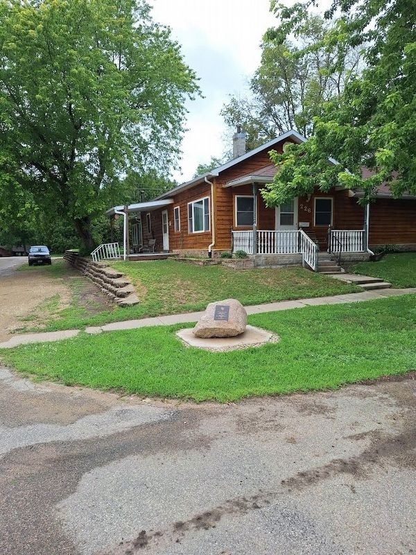
The Bremer County Freedom Rock
First the Iowa Tour and the Bremer County Freedom Rock, located in the pretty little town of Readlyn, Iowa is completed and has been for a couple of weeks. This town is full of great people and . . . — — Map (db m135838) HM
On East Bremer Avenue (Iowa Route 3) just west of 5th Street Northeast, on the right when traveling west.
Erected in tribute to the men of Bremer County who gave their lives to preserve the Union 1861 Civil War 1865James A Adams • James H Akin • David W Baskins • Francis M Baskins • George W Baskins • William Baskins • Yeager Baum • . . . — — Map (db m239690) WM
On East Bremer Avenue (Iowa Route 3) just west of 5th Street Northeast, on the right when traveling west.
In grateful memory of those who died in the service of their country Korean ConflictWiliam Arthur Chapin Lester Henry Diekmann Robert Goodspeed Laurence Mettlin Robert C. Niemann VietnamAllen Avery Verlyn Bruns Donald Francis . . . — — Map (db m239694) WM
On East Bremer Avenue (Iowa Route 3) just west of 5th Street Northeast, on the right when traveling west.
Erected in tribute to the men of Bremer County who gave their lives to preserve the Peace 1914 World War I 1918August Acker • Wm Jay Barber • Fred Beckel • Albert Bockhous • Joe Cretzmeyer • Ira Harker • Emil J Keding • John E Kuethe . . . — — Map (db m239698) WM
On 1st Street Southeast south of 4th Avenue Southwest, on the right when traveling south.
Ira and Asenath Sturdevant House: A Living History Project
Built of brick in 1855-6, the Ira & Asenath Sturdevant house is the oldest surviving dwelling in Waverly, Iowa. The Sturdevants, accompanied and followed by their many adult . . . — — Map (db m277981) HM
On 1st Street Southwest south of 2nd Avenue Southwest, on the left when traveling south.
15 July 1886, Orlando Babcock and others purchased about 29 woodland acres northwest of the BCR&N Short Line bridge across the Shell Rock River. They planned to establish a park for picnicking, fishing and camping. It was a ten-minute railroad . . . — — Map (db m277984) HM
On East Bremer Avenue (Iowa Route 3) just west of 5th Street Northeast, on the right when traveling west.
With the faith and courage of their forefathers who made possible the freedom of these United States The Boy Scouts of America dedicate this copy of the Statue of Liberty as a pledge of everlasting fidelity and loyalty 40th Anniversary . . . — — Map (db m177079) HM
On East Bremer Avenue (State Highway 3) 0.3 miles west of Cedar River Parkway, on the left when traveling west.
Single Roll • Weight – 18 Tons Will crush a rock the size of a 30-gallon barrel Purchased as a used machine for $2800 at Reading, PA. Installed at the Schield Lime Quarry in 1941 — — Map (db m290060) HM
On 1st Street Southwest at East Bremer Avenue (State Route 3), on the right when traveling north on 1st Street Southwest.
Long before the Rock Island Railroad opened its new passenger depot in 1910 on land originally platted by William Sturdevant, this corner was an important commercial location. Edward Knott and his sons John and Alfred operated a horse importing and . . . — — Map (db m237099) HM
On 1st Street Northwest north of 2nd Avenue Southwest, on the right when traveling north.
June 1886 - The Burlington, Cedar Rapids & Northern RR (BCR&N) was contracted to build a Short Rail Line to Waverly from its main north-south line. The Short Line would run from what became known as Waverly Junction, approximately 5 miles . . . — — Map (db m277987) HM
On 4th Avenue Northwest near 1st Street Northwest, on the right when traveling east.
Two architecture students at Iowa State University, Ann Cashman of Waverly and Darian Lu of Shanghai, China, created the unique plan, winning an architectural design competition in the process. Their 18" by 90" design of a community amphitheater . . . — — Map (db m277867) HM
On East Bremer Avenue (Iowa Route 3) just east of 1st Street Northwest, on the right when traveling west.
Soon after the town was originally surveyed in 1853, Waverly’s settlers had timber cleared, a dam in place and buildings constructed. In 1856, citizens constructed a foot bridge across the river, along with a ferry to accommodate teams of horses. . . . — — Map (db m238100) HM
On 1st Street Northwest just north of East Bremer Avenue ( Route 3), on the right when traveling north.
“A dam was thrown across the river, logs, stone and other material being used in its construction...” Account of Harmon building the first dam in 1853, (History of Butler and Bremer Counties, Iowa) The Cedar River was recognized . . . — — Map (db m238174) HM
On 1st Street Northwest just north of East Bremer Avenue (State Route 3), on the right when traveling north.
In 1905 there were again major repairs made to the dam, as well as improvements to the hydro-electric plant including installation of a coal-fired steam plant, which offered increased capacity for producing electricity. In 1908 an explosion and . . . — — Map (db m238179) HM
On 1st Street Northwest just north of East Bremer Avenue (State Route 3), on the right when traveling north.
Throughout Waverly's history the Cedar River has provided a beautiful backdrop for the city, and has been a beloved recreational spot to fish, swim and boat. Long-time Waverly residents have also grown accustomed to flooding. Nearly every decade . . . — — Map (db m238183) HM
On 1st Street Northwest just north of East Bremer Avenue (State Route 3), on the right when traveling north.
For over 150 years, the Waverly Dam has been integral to the city. Over the years the value of the Cedar River to industrial and economic development has led to extended development on the adjacent floodplain. The risk of flooding in Waverly . . . — — Map (db m238187) HM
On North 8th Street (Business Interstate 35) at 2nd Avenue North on North 8th Street.
This World Trade Center steel memorial is dedicated on September 11, 2012 to the memory and honor of the 343 firefighters, 60 law enforcement officers, and 3094 citizens that lost their lives on September 11, 2001 in New York City, at the . . . — — Map (db m276435) HM
On North Shore Drive west of Buddy Holly Place, on the right when traveling west.
The above legends played
their last concert at the
Surf Ballroom,
Clear Lake, Iowa,
on February 2, 1959.
Their earthly life
tragically ended in a
plane crash 5.2 miles
northwest of the
Mason City Airport.
February 3, . . . — — Map (db m89468) HM
On Lake View Drive north of Main Avenue, on the right when traveling north.
The 32nd Iowa Volunteer Infantry
Mustered in on October 6, 1862, the 32nd Iowa Volunteer Infantry would see service in the western theater of the Civil War. Organized in Dubuque, Iowa, the infantry unit originally consisted of 930 men who . . . — — Map (db m89526) HM
On Lake View Drive north of Main Avenue, on the right when traveling north.
G.A.R. Post No. 101 - Clear Lake, Iowa
The Tom Howard Post, No. 101, of the Grand Army of the Republic, was organized Oct. 15, 1872 with the name in honor of Lieut. Thomas Howard of the 32nd Iowa. He was a gallant soldier from Clear Lake, . . . — — Map (db m89528) HM
On Lake View Drive north of Main Avenue, on the right when traveling north.
The Battle of Pleasant Hill
The Battle of Pleasant Hill can be considered as day two of the Battle of Mansfield, or Sabine Cross Roads. Due to the single, narrow road available for advance the Union Army, consisting of infantry, cavalry and . . . — — Map (db m89504) HM
On North Shore Drive east of 7th Avenue North, on the left when traveling east.
Built in 1948
and placed on the
National Register
of Historic Places
by the United States
Department of the Interior
September 16, 2011 — — Map (db m89467) HM
This circular park plays off the musical significance of the neighboring Surf Ballroom and honors the legacies and final performance of Buddy Holly, Ritchie Valens and J.P. "The Big Bopper" Richardson on February 2, 1959. The monument was built and . . . — — Map (db m133139) HM
On Main Avenue at Lake View Drive, on the left when traveling west on Main Avenue.
In memory of
those who served and
gave their lives in
the Vietnam Conflict
————————
Died in Service
John H. Wrisberg, III
January 16, 1968 . . . — — Map (db m89483) WM
Near South Pennsylvania Avenue south of 2nd Street Southeast, on the right when traveling south.
The musical score resounds the spirit of “River City,” a tribute to the community of Mason City from the creator-composer. Meredith Willson May 18, 1902 – June 15, 1984 ”May the good Lord bless and keep you.” A . . . — — Map (db m162292) HM
On Federal Avenue south of 1st Street NW, on the right when traveling south.
Pleasant Hill, La.
O. A. Wilson, Co. B. 32d Iowa,
Died of wounds received at
Pleasant Hill, La. 1864.
Samuel Robins, Co. B. 32d Iowa,
Killed by a falling building
at Eastpoint, Miss. Jan. 22, 1865.
Lieut. W. C. . . . — — Map (db m89718) WM
On 1st Street NE north of State Street, on the right when traveling north.
Frank Lloyd Wright
1908
Prairie School Architecture
In Mason City
This Property is Listed in
The National Register of Historic Places
U.S. Department of [the] Interior — — Map (db m89571) HM
On Washington Avenue (U.S. 65) south of 1st Street NW, on the left when traveling south.
To all veterans that have served during peacetime and conflicts in the Armed Forces of the United States.
To the mothers, fathers, and families whose sons and daughters have made the supreme sacrifice.
To those veterans who still suffer the . . . — — Map (db m89704) WM
[Left Panel]
Steam railroad history began in 1869 for Mason City when the McGregor & Missouri River Rwy laid track from Nora Springs to Clear Lake and became part of the effort to link Chicago with South Dakota, and in 1870-71 when the . . . — — Map (db m89655) HM
On Washington Avenue (U.S. 65) at 1st Street NW, on the left when traveling south on Washington Avenue.
With the faith and courage of
their forefathers who made
possible the freedom of these
United States
The Boy Scouts of America
dedicate this replica of the
Statue of Liberty as a pledge
of everlasting fidelity and
loyalty . . . — — Map (db m89676) HM
On 6th Street SW at South Jackson Avenue, on the right when traveling east on 6th Street SW.
Conceptualized in 1919, incorporated - September 21, 1920. This site for the church was purchased in 1926. The founding members and families of St. John Baptist Church worked diligently to erect a building to bring a small but growing . . . — — Map (db m172803) HM
On State Street at Federal Avenue, on the left when traveling west on State Street.
Frank Lloyd Wright
1910
This property has
benn placed on the
National Register
of Historic Places
by the
United States Department
of the Interior — — Map (db m89586) HM
Minneapolis & St. Louis #457 History
1912 American Locomotive Company of Schenectady, N.Y. built the 457 for the Minneapolis and St. Louis Railroad at a cost of $18,456.03. The Consolidation type locomotive served 38 years for the M&StL, . . . — — Map (db m89634) HM
On 2nd Street NE east of Connecticut Avenue, on the left when traveling east.
These doors turning with the wind, once flew in Vietnam. They now host the names & towns of those from Mason City and surrounding counties who died in in an ungrateful war. You've never really died if you are remembered. These names will be . . . — — Map (db m89533) WM
On Washington Avenue at 3rd Street NW, on the right when traveling south on Washington Avenue.
Dedicated to the memory of
the men who entered the
service of their country
from Cerro Gordo County
and who gave their lives
in the World War
[Dedicated] June 24, 1934 . . . — — Map (db m89729) WM
On County Route S25 at Larch Street, on the left when traveling north on County Route S25.
In honor and memory of all
men and women who served
in the Armed Forces of the
United States of America.
This memorial is not to honor war,
but to show the price of peace lest
future generations forget the
sacrifice made to maintain . . . — — Map (db m89465) WM
On Grand Avenue (U.S. 18/71) just south of East 8th Street, on the right when traveling north.
Who for thirty-five years played Santa Claus to the needy children of this community. May his untiring efforts, his sacrifices and generosity ever be an inspiration to all to share their blessings with those less fortunate. — — Map (db m238883) HM
Fourteen thousand years ago the spot on which you are standing was covered under a mile-high ice sheet. The fourth Wisconsin glacier carved the cluster of lakes into Northwest Iowa. While this north-south cut is typical of glacial lakes, West . . . — — Map (db m142094) HM
Near Circle Drive north of Miriam Lane, on the right when traveling north.
This is the site of the famous
"Spirit Lake Massacre,"
a violent conflict in March 1857 that led to the deaths of 36 settlers. Survivor Abbie Gardner (thirteen years old at the time of the massacre) returned to Arnolds Park and purchased the . . . — — Map (db m233751) HM
On Lake Street 0.2 miles north of Okoboji Grove Road.
American Indians called the Lakes Region home for thousands of years. They were enticed to the lakes for many reasons: the tallgrass prairie provided ample grazing for an abundance of buffalo and elk; the lakes were a flyway for flocks of . . . — — Map (db m142095) HM
On Monument Drive at Miriam Lane, on the right when traveling south on Monument Drive.
The pioneer settlers named below were massacred by Sioux Indians March 8 to 13 1857. This barbarous work was commenced near this spot and continued to Springfield now Jackson Minn.
Robert Clark ·
Rowland Gardner ·
Frances . . . — — Map (db m245504) HM
On Lake Street 0.2 miles north of Okoboji Grove Road.
The Lakes Region was settled in the 1850's. By 1884, small towns had developed and two railroads: The Burlington, Cedar Rapids & Northern; and the Chicago, Milwaukee & St. Pal laid tracks into the area. As hotels were built around the lakes, . . . — — Map (db m142093) HM
On Lake Street 0.2 miles north of Okoboji Grove Road.
In 1889, a water toboggan slide near this pier was the beginning of the Arnolds Park Amusement Park. Toboggans and wool swim suits could be rented by the day.
Over the next century, the area, named after pioneer developer Wesley Arnold, . . . — — Map (db m142092) HM
On Hill Avenue just south of 18th Street (U.S. 71), on the right when traveling south.
In Memoriam Honoring our Veterans of Dickinson County, both Men and Women. “America will never be destroyed from the outside, if we falter and lose our freedoms, it will be because we destroyed ourselves.” Abraham . . . — — Map (db m238889) WM
On Hill Avenue at 18th Street (U.S. 71), on the right when traveling north on Hill Avenue.
This property is listed in The National Register of Historic Places Iowa State Historical Department Division of Historic Preservation — — Map (db m238671) HM
On 18th Street (U.S. 71) at Hill Avenue, on the left when traveling west on 18th Street.
This tablet marks the spot where the people of this community were sheltered during the Indian Uprising of 1861 and 1862
Dedicated to the pioneer men and women of Dickinson County — — Map (db m233805) HM
Near 340th Avenue (County Highway N22) 0.3 miles north of 110th Street, on the left when traveling north.
State Line Congregation, Augustana Synod was organized April 11, 1871. A number of families had been active in the State Line Trustee District of the Estherville Lutheran Church. In 1887 these two groups organized the Union State Line Lutheran . . . — — Map (db m232785) HM
Near Tuttle Lake Road 0.2 miles north of 110th Street (County Highway A13), on the left when traveling north.
Discovered by Jean Nicollet 1838
Camp site of General Fremont
and later of Major T. W. Sherman
on Government Road surveyed in 1860
Okamanpadu Park
Donated by E.L. and J.C. Williams
Tablet placed by Okomanpado Chapter . . . — — Map (db m232789) HM
On Central Avenue (Iowa Route 9) just west of North 7th Street, on the right when traveling west.
Memorial honoring Emmet County Veterans Erected by Estherville Chapter Service Star Legion originally War Mothers of America 1918 1938 Paul Atbey • Glen A. Alt • Stanley Alt • Steven Andrea • Dewey Allgood • Harvey L. Arnett • Norman Andrews . . . — — Map (db m238196) WM
Near West North 1st Street south of West 2nd Avenue North, on the right when traveling north.
This suspension cable swinging bridge was built at the site of the "Old Mill Dam" in 1937. Labor for the construction was furnished by the Works Progress Administration (WPA), part of Franklin D. Roosevelt's "New Deal" Program. The bridge was . . . — — Map (db m233860) HM
Near West North 1st Street south of West 2nd Avenue North, on the right when traveling north.
This suspension cable swinging bridge was built at the site of the "Old Mill Dam" in 1937. Labor for the construction was furnished by the Works Progress Administration (WPA), part of Franklin D. Roosevelt's "New Deal" Program. The bridge was . . . — — Map (db m233861) HM
On North 6th Street just north of Central Avenue (State Route 9), on the right when traveling north.
Donated to Estherville by the Elmer Weir family, Sept. 1, 1985 in memory of Stanley Larsen who exemplified good health & vigor and refused to grow old. — — Map (db m238190) HM
On North 6th Street north of 1st Avenue North, on the right when traveling north.
Erected on block 59, original plat of Estherville, Iowa, by Company A, Northern Border Brigade, for the protection of settlers against marauding Indians.
To the memory of the pioneers of Emmet County, Iowa and in honor of the patriotic . . . — — Map (db m232788) HM
On State Highway 4 at 390th Avenue, on the right when traveling north on State Highway 4.
Fell 482 feet due west of this spot on May 10, 1879. • • • It was one of the three greatest “falls” on record. • • • Parts of the meteorite are found in important museums of the world. — — Map (db m176315) HM
On N Jackson Street at Blunt Street, on the left when traveling south on N Jackson Street.
Presented by
Charles City Woman’s Club
In memory of
Those who lost their lives
In the tornado of
May 15, 1968
Sadie Chambers · Ruth Dawson · Harry Hall · Marie Greenlees · May Gault · Arthur Jacobs · Minnie Kneisel · John Kneisel · . . . — — Map (db m104112) HM
On Gibert Street (U.S. 18) at Hildreth Street, on the left when traveling north on Gibert Street.
Andres Memorial Park
Winnebago Indian Encampment Area
Park of Village of Freeman – 1853
McKinley School Site
1871 to 1968
Destroyed by Tornado May 15, 1968
Original McKinley Schoolbell used as
Memorial to
Leonard & Matilda . . . — — Map (db m104060) HM
On Riverside Drive just west of North Main Street, on the right when traveling west.
Iowa Historic District Central Park–North Main Street Historic District ———————— Farmer’s Trust and Savings Bank ca. 1900 This district is listed in The National Register of Historic Places — — Map (db m236691) HM
On Main Street at Court Street, on the right when traveling south on Main Street.
Duty Honor Sacrifice
This memorial is dedicated to all Floyd County area veterans who have honorably served, are currently serving or will serve in the uniformed services of the United States during peacetime, conflict or war.
Let this . . . — — Map (db m103648) WM
On North Main Street just south of Riverside Drive, on the right when traveling south.
Has been placed on the National Register of Historic Places by the United States Department of the Interior Main Street Bridge and Central Park Lighting Project Contributors Dr. Robert & Norma Breitbach • Dr. Robert & Mary . . . — — Map (db m236684) HM
On North Main Street just south of Riverside Drive, on the right when traveling south.
1855 — Used at Joseph Kelly’s Feed, Flour and Sawmill at original dam one block west at Jackson Street 1875 — Mill closed – wheel laid on bank of river for years 1897-1947 Marten Brothers Blacksmiths used wheel to shrink wagon-wheel tires . . . — — Map (db m236643) HM
[Fleet Admiral William Daniel Leahy was born in Hampton, Iowa and was an American naval officer who served during World War II.]
_ _ _ _ _ _ _ _ _ _
[Folded flag a solemn piece in honor of those who've served and made the ultimate . . . — — Map (db m135909) WM
On Raven Avenue at 105th Street (County Highway C47), on the right when traveling north on Raven Avenue.
James B. Reeve
Adaline Reeve
Fernando, Henry, Orrilla, Orson, Beulah, Rumsey, Susan, Albert, Ellen, Herman, Emily.
August 5, 1855
County organized and first election held in a log house 40 ft. west. County business was transacted . . . — — Map (db m172624) HM
On 110th Street 0.2 miles west of Olive Avenue, on the right when traveling west.
1936 The Rural Electrification Act (R.E.A.) signed by President Franklin Roosevelt provided loans for the purpose of construction of rural electrical generating plants.
1937, Feb. 10 - The Federated R.E.A. was incorporated forming together . . . — — Map (db m172575) HM
On 110th Street (County Highway C47) at Raven Avenue, on the right when traveling east on 110th Street.
In 1853, Leander Reeve and James Reeve broke 10 acres of native prairie before returning to Ohio for their families.
In 1854, Leander Reeve build a house of native lime stone. It remained a family home throughout the 1950s. After this, the empty . . . — — Map (db m172626) HM
On State Street at West 4th Street, on the right when traveling south on State Street.
In Memoriam - U.S.S. Maine - Destroyed in Havana Harbor - February 15th 1898
This tablet is cast from metal recovered from the U.S.S. Maine.
Presented to the City by the John Stanton Chapter — D.A.R. — — Map (db m176306) WM
On North Thorington Street just north of West State Street, on the left when traveling north.
In memory of James C. Taylor Post No. 165 and all Union soldiers of the Civil War 1861-1865 Presented by Womans Relief Corps No. 208 Algona, Iowa Dedicated 1930 — — Map (db m238892) WM
On West State Street just west of North Thorington Street, on the right when traveling west.
In grateful tribute to all men and women of Kossuth County, who have or will serve in the defense of our country. Air Force ☆ Army ☆ Coast Guard ☆ Navy ☆ Marines Dedicated by Veterans organizations and citizens of Kossuth . . . — — Map (db m238895) WM
On West State Street just east of North Hall Street, on the right when traveling west.
The namesake of Kossuth County. Kossuth was a Hungarian freedom fighter and leader of the 1848-1849 revolution for Hungarian independence. He was known as one of the greatest statesmen and orators of the mid-19th century. He was a prominent figure, . . . — — Map (db m161703) HM
152 entries matched your criteria. The first 100 are listed above. The final 52 ⊳