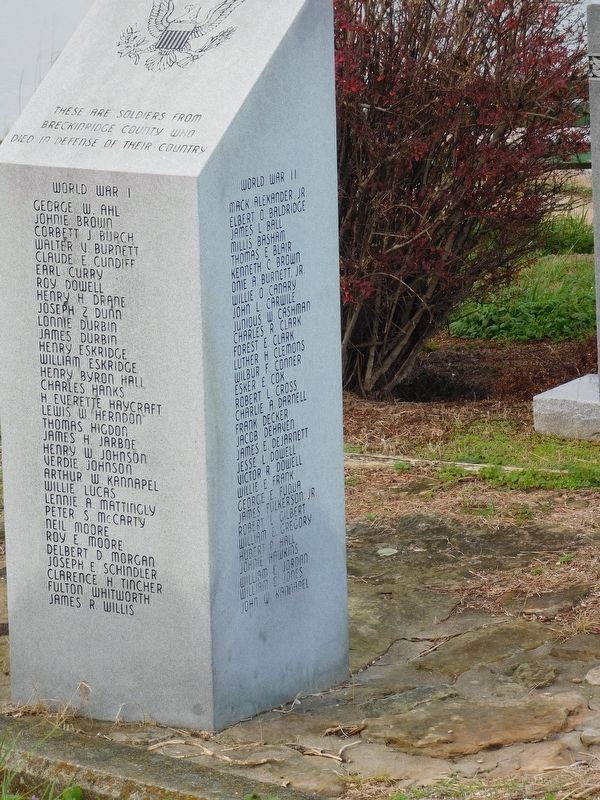
On West Main Street (State Road 2200) at Center Street, on the right when traveling west on West Main Street.
These are soldiers from
Breckinridge County who
died in defense of their country
World War I
George W. Ahl • Johnie Brown • Corbett J. Burch • Walter V. Burnett • Claude E. Cundiff • Earl Curry • Roy Dowell • Henry H. Drane • Joseph Z. . . . — — Map (db m160275) WM
The late 1920's saw a change in the economic health of the town. The railroad shops closed, putting many men out of work during the Depression years. The town's population began to decline after the closing of its last big industry, the tile . . . — — Map (db m286527) HM
On West Front Street west of Elm Street, on the left when traveling east.
Cloverport's early beginnings occurred midway through the westward movement in the Kentucky Territory. The vast resources Kentucky had to offer attracted people before 1729. Interest in the trading potential of the river and thick virgin woods . . . — — Map (db m286542) HM
On West Front Street west of Elm Street, on the right when traveling east.
In 1803 Houston applied to establish a town east of Clover Creek. The court granted the petition and set aside 150 acres of land for the town of Joeville. One of the earliest established businesses in the new town was the trading post, owned and . . . — — Map (db m286540) HM
On West Front Street west of Elm Street, on the right when traveling east.
In the autumn of 1816, the family of Thomas Lincoln pulled in to Joeville, seeking to cross the Ohio River into Indiana. Among the family was young Abe Lincoln. Previously the ferry transported only goods, but was now rebuilt to also carry . . . — — Map (db m286536) HM
On West Front Street west of Elm Street, on the right when traveling east.
In 1830, cannel coal was discovered six miles outside of Cloverport in Hancock County at Bennettsville, later known as Victoria. A clean burning coal that would eventually light the bulbs at Buckingham Palace. Queen Victoria became a stockholder . . . — — Map (db m286532) HM
On Elm Street north of West Main Street, on the right when traveling north.
Cloverport continued to prosper and grow for the rest of the century. The old wooden bridge was replaced by an iron bridge in 1873 and by 1876 the Breckinridge News had begun. Cloverport was the site for the first natural gas well, drilled in . . . — — Map (db m286529) HM
On Elm Street north of West Main Street, on the right when traveling north.
On the night of March 13, 1901, fire broke out in a private home on Main Street, located today about three blocks west of the bridge. Strong northwest winds fanned the flames. When a tobacco warehouse, located where the Baptist Church stands . . . — — Map (db m286528) HM
On West Main Street (State Road 2200) at Center Street, on the right when traveling west on West Main Street.
Dedicated
to all veterans of
Cloverport, Kentucky
to the honor and
glory of those who
bravely served to
keep our country
a land of freedom — — Map (db m160274) WM
On West Main Street (State Road 2200) at Oak Street, on the right when traveling west on West Main Street.
Cloverport, an important shipping point beginning in 1798 when Joe Houston came from Va.: built home and started trading and shipping business. Flatboats carried Ky. tobacco, other goods for sale in New Orleans. Boats sold as lumber. Men came back . . . — — Map (db m160276) HM
On West Main Street (Kentucky Route 2200) east of Center Street, on the right when traveling west.
Coal oil first produced here 1851. Plant built 1857, reputed first of kind in world. Mine known for extensive veins of cannel coal. Coal loaded here, exported to England via New Orleans for gas manufacture. English-owned with Prince of Wales (King . . . — — Map (db m119795) HM
On West Main Street (Kentucky Route 2200) at Center Street, on the right when traveling west on West Main Street.
Abraham Lincoln, then a lad of 7, with other members of the Thomas Lincoln family crossed the Ohio River on a log raft ferry near here in 1816. The Lincolns were moving to Indiana. — — Map (db m119796) HM
On West Street at Verden Street, on the right when traveling west on West Street.
Four miles south. A fashionable health resort of 1840s which had the unique attraction of a 100-foot cliff from which tar bubbled while from its base flowed eleven springs, each with different type of mineral water. Indians knew and used these . . . — — Map (db m160289) HM
On Blacklick Church Lane west of Rockvale Road ( Route 629), on the right when traveling west.
On October 15, 1959. Kentucky experienced the Cold War firsthand. Above Hardinsburg, KY. a B-52 bomber collided with a KC-135 tanker during a mid-air refueling. The 2 aircraft were flying a training mission with 2 nuclear weapons aboard. These . . . — — Map (db m290226) HM
On South Main Street at East 2nd Street (Business U.S. 60), on the right when traveling south on South Main Street.
★ Honor Roll ★
In memory of the Breckinridge County
heroes of the World's War, 1914-1918
George W. Ahl • Johnie Brown • Corbett J. Burch • Walter V. Burnett • Claude E. Cundiff • Earl Curry • Roy Dowell • Henry H. Drane • . . . — — Map (db m160317) WM
On 2nd Street (Business U.S. 60) at South Main Street ( Route 261), on the right when traveling east on 2nd Street.
For John Breckinridge, 1760-1806. Attorney General of Kentucky, 1793-97. Representative in Kentucky Legislature, 1797-1801. Coauthor with Jefferson of 1798 Kentucky Resolutions, opposing U.S. Alien and Sedition Acts. Appointed Attorney General of . . . — — Map (db m119798) HM
On 2nd Street (Business U.S. 60) west of South Main Street ( Route 261), on the right when traveling east.
Twenty-two Kentucky courthouses were burned during Civil War, nineteen in last fifteen months: twelve by Confederates, eight by guerrillas, two by Union accident. See map on reverse side. Dec. 28, 1864, guerrillas set fire to courthouse at . . . — — Map (db m119797) HM
On U.S. 60 at Road 144, on the right when traveling west on U.S. 60.
Six miles north are birthplace and grave of Joseph Holt, 1807-1896. He was commissioner of patents, postmaster general, and secretary of war in President Buchanan's administration, 1857-1861. Lincoln named him judge advocate general of the Union . . . — — Map (db m160290) HM
On State Road 144, on the right when traveling south.
This is birthplace and grave of Joseph Holt, 1807-96. He served as Commissioner of Patents, Postmaster General, and Sec. of War in Pres. Buchanan's Administration. 1857-61.
Lincoln named him Judge Advocate General of the Union army in 1862. Holt . . . — — Map (db m160293) HM
On State Road 144, on the right when traveling west.
Breckinridge County native Joseph Holt played an important role in keeping Kentucky in the Union during the Civil War. He also prosecuted the Lincoln assassination conspirators.
Born on January 6, 1807, Holt attended Centre College in Danville, . . . — — Map (db m160297) HM
On State Road 144, on the right when traveling south.
The second-son of a wealthy Breckinridge County family, Joseph Holt inherited 10,000 acres of lush farmland here along the Ohio River. Though he was away for many years, this place was always home.
Influential and Powerful
Joseph Holt . . . — — Map (db m160296) HM
On South Main Street (State Road 261) 0.1 miles south of FFA Camp Road, on the left when traveling south.
In the autumn of 1816 the family of Abraham Lincoln, then 7 years old, migrating to Indiana, rested and recuperated about three weeks in a cabin that stood near here. Local residents gave them food. Lincoln route in Kentucky started near Hodgenville . . . — — Map (db m162245) HM
On North Main Street (State Road 259), on the right when traveling north.
Founded in 1810 by Fr. Charles Nerinckx, a Catholic missionary from Belgium. It is the oldest parish remaining at one location in the Diocese of Owensboro. Original 3 acres of land donated by Zachariah Mattingly. First log church built in 1810; . . . — — Map (db m160316) HM
On U.S. 60 0.5 miles east of Low Dowell Road, on the left when traveling east.
At age of 17, in 1861, Jerome Clarke, called Sue Mundy, joined Confederate Army. He was with Morgan's Raiders from 1862 until Morgan's death in 1864. He then became notorious as a guerrilla. On March 12, 1865 Union soldiers captured him here with . . . — — Map (db m162244) HM
On Kentucky Route 144 0.2 miles west of Knottsville St Lawrence Road.
In 1795, James Knott emigrated from Maryland to Cox’s Creek Settlement in Nelson County, Ky., as part of the “League of Catholic Families.” Born in 1797, his son Leonard married Mary M. Drury and moved to Daviess County in 1826. They . . . — — Map (db m47838) HM
On Bolling Heights Lane 0.1 miles north of Road 2116, on the right when traveling north.
Richard Hawes (1772-1829) and wife Clary Walker Hawes (1776-1848) came here 1810 from Va. Their son Richard was Confederate governor of Ky. After husband's death, Clary was licensed to operate Hawesville and Cannelton ferry, 1831. Cemetery long . . . — — Map (db m160194) HM
On U.S. 60 1.2 miles east of Kelly Cemetery Road, on the right when traveling east.
Site of Riley family homeplace, owners of Josiah Henson, one of the characters on which Harriet Beecher Stowe based her 1852 novel Uncle Tom's Cabin. Henson served as overseer of Amos Riley's farms, 1825-29. On learning owner planned to sell . . . — — Map (db m160204) HM
On Locust Street north of West 7th Street, on the right when traveling north.
This imposing Victorian structure built circa 1860 by Dr. William Doswell Stirman, a successful physician. Received its name because he spent a fortune building it. In 1915, Samuel R. Ewing, civic leader and tobacco farmer, purchased and remodeled . . . — — Map (db m160124) HM
On Airport Road (State Road 2118), on the right when traveling east.
Albert Smith Marks birthplace site, Oct. 16, 1836. Moved to Tennessee at age 19. Served as the 24th governor of that state, 1879-81, following distinguished service in Civil War. Enlisted early in the Confederacy, rising to rank of colonel. Battle . . . — — Map (db m159323) HM
On Road 144 at Yellow Creek Park, on the right when traveling east on Road 144.
Col. Algernon S. Thruston
Lawyer, soldier and farmer. Born in Louisville 1801, died 1864 at Thruston. Went to Texas with company of volunteers in 1836. Commissary General of Purchases (1837) and Quartermaster General (1838) for the Republic . . . — — Map (db m160173) HM
On West Veterans Boulevard at Frederica Street, on the right when traveling west on West Veterans Boulevard.
Site of home of William Smeathers (Bill Smothers), who in 1797-98 made first permanent settlement at Yellow Banks, now Owensboro. Officer in Kentucky's "Corn Stalk" Militia in 1803 and on expedition up the Wabash River against the Indians in the War . . . — — Map (db m160142) HM
Near West 5th Street at Cs-1186-30, on the right when traveling west.
Every African-American family holds in high esteem women whose strength in the face of overwhelming odds provided hope and encouragement. Women have worked to strengthen their communities of family, neighborhood, school and church.
Teaching . . . — — Map (db m159345) HM
On West 10th Street at Frederica Street ( Road 2831), on the left when traveling east on West 10th Street.
Buffalo herds opened first road in wilderness to present site of Owensboro. Bill Smothers, the pioneer settler of Yellow Banks, followed trail from Rough Creek, near present day Hartford, to Ohio River. Built his cabin at end of road, near here, . . . — — Map (db m159329) HM
On West 3rd Street at Frederica Street, on the right when traveling west on West 3rd Street.
(side 1)
The President, CSA, in 1862, was authorized to confer a Medal of Honour upon one enlisted man of each company for "every signal victory." At first dress-parade, thereafter, the men engaged in the battle chose, by vote, the . . . — — Map (db m119830) HM WM
On West 2nd Street west of St Ann Street, on the left when traveling west.
Twenty-two Kentucky courthouses were burned during Civil War, nineteen in last fifteen months: twelve by Confederates, eight by guerrillas, two by Union accident. See map on reverse side.
Jan. 4, 1865, the courthouse at Owensboro, occupied by . . . — — Map (db m119800) HM
On West 2nd Street east of Frederica Street, on the left when traveling west.
In 1864, several hundred enslaved African American men joined the Union army here. Enlisting in the army meant eventual freedom for the men and their families. Units raised in Daviess Co. took part in important operations at Richmond, Petersburg, . . . — — Map (db m119826) HM
On St Ann Street south of West 2nd Street, on the left when traveling north.
During World War I approximately 80,000 men enlisted from Kentucky. Of this number 1,747 that answered the call to serve, between April 1917 and November 1918, were from Daviess County. Seventy-one were killed in action and seventy-six others . . . — — Map (db m119828) HM WM
On New Hartford Road (U.S. 231) just south of Spring Bank Drive, on the right when traveling north.
Formed in 1815 out of Ohio County. Named for Col. Joseph Hamilton Daveiss. As US attorney for Ky., he prosecuted Aaron Burr in 1806 for treason, in plotting to seize Spanish territory, a friendly nation; but he did not obtain a conviction. Joined . . . — — Map (db m159320) HM
On West 4th Street at Poplar Street, on the right when traveling east on West 4th Street.
Dr. Clay E. Simpson, Sr., native of Notasulga, Alabama and his wife Mary E. Simpson, native of Fayette County, Kentucky, served the Owensboro community for many years. As a Family Physician, Dr. Simpson made numerous house calls and delivered . . . — — Map (db m160137) HM
On River Road (State Road 331), on the right when traveling north.
Robert Triplett built the first railway in Kentucky, 1826. Coal was moved from Bon Harbor hills to steamboats on the Ohio River. Triplett was first to get coal substituted for wood as fuel on river boats below Louisville. Coal was shipped south, . . . — — Map (db m160127) HM
On East 7th Street at Crittenden Street, on the right when traveling west on East 7th Street.
Wendell H. Ford, Kentucky's 49th Governor, first Owensboro native to become Chief Executive. Born Sept. 8, 1924. Served in U.S Army during World War II and National Guard, 1949-62. Elected National Jaycees President, 1956; International Vice Pres., . . . — — Map (db m159330) HM
On West 4th Street east of Poplar Street, on the left when traveling east.
In 1830, a Baptist church began in a log cabin-house, which was provided for Black worshipers by Philip Thompson. The congregation was first led by Black Baptist Minister Oliver Potts. The Black Baptist Church was founded after the Civil War & in . . . — — Map (db m160131) HM
On West 3rd Street west of St Ann Street, on the right when traveling west.
George Graham Vest
Established Owensboro’s second newspaper, The Gazette, near here in 1852, with Robert S. Triplett, an Owensboro businessman.
Vest was U.S. Senator from Missouri, 1879-1903. Author of world famous “Tribute to a . . . — — Map (db m119847) HM
On State Road 2830 0.1 miles north of Ellis Smeathers Road (County Road 1091), on the right when traveling north.
About 60,000 acres along Panther Creek and Green River owned by George Mason, author of Va. Bill of Rights and Constitution, 1776. Designed Va. State Seal. Member Continental Congress, 1777, and U.S. Constitutional Convention. A Virginian, friend . . . — — Map (db m160159) HM
On Daviess Street north of East 4th Street, on the right when traveling north.
First Kentuckian to receive "70 Continuous Years of Service Award" from Boy Scouts of America, 1983. Scoutmaster for over 50 years; with Owensboro's oldest troop, 24, from
1949 till death. Among many honors, he received Scoutmaster's Key and Silver . . . — — Map (db m160147) HM
On State Road 405 0.4 miles north of Wrights Landing Road (State Road 1831), on the left when traveling north.
Revolutionary War Captain. Member, from Madison Co., 1792 and 1799, Ky. Constitutional
Conventions; Ky. House of Rep., 1792-93, and 1796-98; Ky. Senate, 1793-95. Came here in 1812. Cousin of John Clay, father of renowned Ky. statesman Henry Clay, . . . — — Map (db m160191) HM
On West 5th Street at Cs-1186-30, on the right when traveling west on West 5th Street.
This park was formerly known as Douglas Park in honor of Frederick Douglas, slave abolitionist. In 1973, renamed in memory of Joe N. Kendall and Joseph P. Perkins, two contemporary citizens of this community. These men gave many years of unselfish . . . — — Map (db m159342) HM
On State Highway 56 at Hayden Bridge Road (State Highway 279), on the right when traveling west on State Highway 56.
James Madison, 4th U.S. president, and wife, Dolly, owned 2,000 acres along Panther Creek, now Daviess County. Land held by them until sold in smaller acreages, 1832-34. Madison was member of Continental Congress, 1780-83, 86-88 and of Federal . . . — — Map (db m160063) HM
On Frederica Street south of West 2nd Street, on the right when traveling north.
(side 1)
Daviess Co. natives who have received the Medal of Honor:
John J. Given–Corp, Co K, 6th U.S. Cavalry. Died while trying to recover a fallen soldier at Wichita River, Texas, July 12, 1870.
Thomas Cruse- 2nd . . . — — Map (db m119829) HM WM
On West 7th Street at Walnut Street, on the right when traveling west on West 7th Street.
Moneta J. Sleet, Jr.
Born in Owensboro. Sleet was a graduate of Ky. State College and New York Univ. Beginning in 1955, he worked as photojournalist for Jet and Ebony magazines for 41 yrs. During the 1950s-60s, his photos . . . — — Map (db m159338) HM
On West 2nd Street at Frederica Street, on the left when traveling west on West 2nd Street.
This bell, once used to notify the people court was in session, hung in Daviess County's fourth court house from 1876 until the 96-year-old building was demolished in 1964 to make way for a new Temple of Justice. — — Map (db m243590) HM
On West 5th Street at Ewing Court, on the right when traveling west on West 5th Street.
Erected in 1875, this building is the oldest example of Gothic architecture in Western Kentucky. Served as Trinity Episcopal Church, oldest brick church building in Owensboro, until 1964, when it was occupied by The Cliff Hagan Boys Club. The . . . — — Map (db m159333) HM
On Locust Street just south of West 5th Street, on the right when traveling south.
A portion of this property was generously donated to the City by Haley McGinnis & Owensboro Funeral Home in the year 1977.
The combined efforts of the Beautification Committee, the Parks Department and Street Department have retained the . . . — — Map (db m159336) HM
On Woodford Avenue 0.1 miles north of Herr Avenue, in the median.
This park is dedicated to Peter B. English in honor of his many years of service to the United States Corps of Engineers and to the City of Owensboro. Through his tireless
efforts, the land for this park became a reality. An avid sportsman, . . . — — Map (db m160129) HM
On Bittel Road at Dallas Avenue, on the right when traveling west on Bittel Road.
This park is dedicated to Russell Shifley in honor of his 56 years of service to the City of Owensboro. This man was employed by the City of Owensboro in 1917, and served
as Superintendent of the Sewer and Street Department from 1930-1971. . . . — — Map (db m159322) HM
On Frederica Street (State Road 2831) at Maple Avenue, on the right when traveling south on Frederica Street.
This giant tree, first mentioned for its size in 1883, has been an historic landmark in Daviess County for several centuries. Believed to be 250 or 300 years old, it measures over 100 feet tall, with a circumference of 16 feet. It is probably the . . . — — Map (db m159324) HM
On Griffith Avenue at Mccreary Avenue, on the right when traveling east on Griffith Avenue.
Homesite of Thomas Clay McCreery. Born in 1816. He died in 1890. He was one of Daviess County's most distinguished natives, an accomplished lawyer, orator, and farmer. A presidential elector in 1852, 1856, 1860. United States senator from 1868-71, . . . — — Map (db m159326) HM
Near West 5th Street at Cs-1186-30, on the right when traveling west.
The years after the Civil War saw Owensboro's African-American community grow. The more than 3,000 blacks in Daviess County dwelt mostly in the rural areas in 1860, but by 1900 most lived in Owensboro. The lure of jobs, changes in agriculture, . . . — — Map (db m159355) HM
Near West 5th Street at Cs-1186-30, on the right when traveling west.
The end of slavery in 1865 brought many challenges to Owensboro's African-American population. They struggled to find jobs, establish homes, educate their children, and find their place in the post-war world.
In 1880 a system of schools for . . . — — Map (db m159343) HM
On Frederica Street (State Road 2831) at West 11th Street, on the right when traveling north on Frederica Street.
Built 1905-6, on site of the Louisville, Henderson and St. Louis depot. It represents an agreement between the Louisville, Henderson and St. Louis; the Louisville and Nashville; and the Illinois Central railroads to provide Union Station for . . . — — Map (db m159327) HM
On State Highway 142 at Millers Mill Road (State Highway 762), on the right when traveling north on State Highway 142.
This congregation was organized on Oct. 5, 1825, in log house. New meeting house, on the site of present cemetery, built 1832. Current brick church erected in 1854, with clay from the original site. Six churches have grown from Bethabara: Macedonia, . . . — — Map (db m159289) HM
On U.S. 431 at Sharp Road, on the right when traveling south on U.S. 431.
Sept. 19, 1862, Confederate force occupied Owensboro. USA troops at old Fairgrounds refused demand for surrender. Skirmish followed. Union soldier swam Ohio River to summon help from Indiana Legion. CSA retired to here. Home Guards from Indiana . . . — — Map (db m159290) HM
On Kentucky Route 764 just south of U.S. 231, on the right when traveling north.
Pleasant Point Missionary Baptist Church. Six emancipated slaves formed this congregation in 1871. Three years later it was fully organized: the church erected in 1878. Membership grew as African Americans searched for religious & cultural . . . — — Map (db m159288) HM
On Ward Road at East Millerstown Road ( Route 224), on the right when traveling north on Ward Road.
Millerstown, settled before 1800, founded by Jacob Miller, Jr. He owned 500 acres along Nolin River and built grist mill. Christopher, a brother, was prisoner of Indians for 11 years; rescued by spies of Anthony Wayne, he then helped Wayne secure . . . — — Map (db m290229) HM
On Jenny Green Road at Green Farm Road, on the right when traveling south on Jenny Green Road.
Built in 1823, this mill, operated
continuously by the Green family
for over 140 years. It was part of
6,000-acre farm-timber complex
supporting several family owned
industries. Farmers from seven
counties brought grain for milling
into . . . — — Map (db m301212) HM
On Falls of Rough Road (State Road 79) at Robinson Road, on the right when traveling south on Falls of Rough Road.
George Eskridge, born in Virginia in 1763, served in Revolutionary War, having enlisted in the Virginia Continental line at an early age. Eskridge came to Kentucky and settled in Grayson County, circa 1811. Built a log house at Falls of Rough River . . . — — Map (db m162247) HM
On Grayson Springs Road west of Western Kentucky Parkway, on the right when traveling west.
Built in 1847 by Benjamin Lone Rogers,
around a log cabin that dates back to
1789. Mansion took its name from a
cluster of trees that originally grew in
front of the house. This transitional Greek
Revival structure is one of the oldest . . . — — Map (db m171785) HM
On Public Square at North Main Street (U.S. 62), on the left when traveling south on Public Square.
For Col. William Grayson, 1740-90,
aide de-camp to Gen. Washington.
Lawyer; in Revolutionary Army,
1776-79; Board of War, 1780-81;
Virginia Assembly and Continental
Congress, 1784-87; State Convention
ratifying Federal Constitution . . . — — Map (db m123269) HM
On Public Square at East Main Street, on the left when traveling north on Public Square. Reported missing.
Twenty-two Kentucky courthouses were burned during Civil War, nineteen in last fifteen months: twelve by Confederates, eight by guerrillas, two by Union accident. See map on reverse side.
Dec. 24, 1864, a contingent of CSA Gen. Lyon's force . . . — — Map (db m123438) HM
On Public Square at West Main Street, on the left when traveling south on Public Square.
In memory of the men of Grayson County who gave their lives for our freedom.
Martin Alvey, Verna Anderson, Edgar Baker, Emmett Beville, Oscar Boone, Malcolm Bozarth, Floyd Brooks, Andrew Cannon, Miles Dennison, Robert Downs, Willis Duggins, . . . — — Map (db m125032) WM
On Grayson Springs Road (Kentucky Route 1214) west of Route 88, on the right when traveling east.
Site of famous spa started in mid-1820's, owned by M. P. Clarkson, and known for healing powers of its mineral water springs. Resort reached its height in 1900 under ownership of Mercke brothers. Also home of St. Augustine's, first Roman Catholic . . . — — Map (db m290228) HM
On East Main Street at South Clinton Street, on the right when traveling east on East Main Street.
First story, east wing of house, was the earliest brick residence in Grayson County. It was built ca. 1810 by Jack Thomas, first county and circuit court clerk. He added two-story brick wing on north, Federal style. Despite alterations of the . . . — — Map (db m123436) HM
On South Clinton Street at East Main Street, on the right when traveling south on South Clinton Street.
Leitchfield was laid off 1810, and named for David Leitch, prominent landowner and founder of Leitch's Station. His estate gave land for Grayson's county seat. Site chosen because of fresh water springs, particularly "Big Spring" nearby. Grayson's . . . — — Map (db m123434) HM
On Elizabethtown Road (U.S. 62) at Shaw Station Road, on the right when traveling west on Elizabethtown Road.
Shaw's Station
Named for Benham (Bonum) Shaw, this pioneer settlement (today's Leitchfield) was located at the headwaters of Beaver Dam Creek. This station was a stop along the important trail which ran from settlements at Nashville, Tenn., . . . — — Map (db m123433) HM
On Indian Lake Drive (State Road 3199) at Scenic Hilltop Road, on the right when traveling west on Indian Lake Drive.
Below is view of the river bottom land where John Cannon, riverboat captain and builder
of fine steamboats for lower Mississippi trade, was born in l820. By 1840 this skilled pilot began his career as steamboat entrepreneur. He built and piloted . . . — — Map (db m160229) HM
On U.S. 60 at Jennings Street, on the right when traveling north on U.S. 60.
Captain William Davison
Confederate Captain William Davison is buried here. He died March 7, 1865, from a gunshot wound suffered in a firefight with Union Home Guard, February 24, 1865, near Patesville during the Civil War. Davison led a . . . — — Map (db m160225) HM
On Main Street (Kentucky Route 69) at Madison Street ( Route 69), on the right when traveling south on Main Street.
For John Hancock, 1737-93. Patriot, statesman and soldier. President of Continental Congress, 1775-77, and bold first signer of the Declaration of Independence. Mayor-general of Mass. militia in Revolutionary War, member of the Mass. Constitutional . . . — — Map (db m119794) HM
On State Road 1389 at Franklin Gaynor Road, on the right when traveling east on State Road 1389.
Site of Hancock's first county court, 300 yds. south, held in home of James Dupey, Mar. 1829. The two-story log structure also scene of first circuit court, in April. Samuel C. Jennings appointed clerk; John Sterett, sheriff. County seat was to be . . . — — Map (db m160233) HM
On Main Street at Washington Street, on the right when traveling north on Main Street.
Hancock County and Hawesville were created by Ky. law Jan. 3. 1829. County seat was named for Richard Hawes who donated land for town. His son, Richard Jr., became Confederate governor of Kentucky, 1862. Hancock's first cannel coal produced . . . — — Map (db m160228) HM
On River Street north of Bridge Street, on the right when traveling north.
(side 1)
Rails of Louisville, St. Louis, and Texas Railroad laid here June 9, 1888. First passenger train ran between Owensboro and Stephensport Oct. 7, 1888. Service between Evansville and Louisville began in April 1889. Rail line . . . — — Map (db m119799) HM
On State Road 3543 north of U.S. 60, on the right when traveling north.
Home of Robert C. Beauchamp
Robert Costain Beauchamp (1800-1884) was a farmer and businessman who served Hancock County in the state legislature from 1867-71. He eventually owned 5,000 acres of land in this county. Beauchamp was one of the . . . — — Map (db m160223) HM
On State Road 144 at Quisenberry Road, on the right when traveling east on State Road 144.
Crossroads was site of 19th-century town of Patesville. It was named for William Pate, who bought land and operated an inn about two miles east of here. A post office established, 1813. During Civil War, area was site of a gun battle pitting CSA . . . — — Map (db m160239) HM
On 4th Street at Pell Street ( Road 334), on the right when traveling south on 4th Street.
Formerly called Little Yellow Banks, town was renamed Lewisport in 1839 in honor of John Lewis, one of the first permanent settlers in area. He was an early surveyor of land between Salt and Green rivers. Original town plat drafted by James and John . . . — — Map (db m160213) HM
On River Road (State Road 334) 0.5 miles south of Adair Road (State Road 1605), on the right when traveling south.
Abraham Lincoln, 16th president of United States, won his first law case here, 1827. Charged by the Commonwealth of Kentucky with operating ferry without license; Lincoln pleaded his own case in trial at the home of presiding Justice of the Peace, . . . — — Map (db m160222) HM
On 4th Street north of New Front Street when traveling north.
Site of Front Street
Lewisport's first business district was along river on Front St. First permanent store built by Joseph C. Pell, 1841; his was only structure standing on Front St. after 1849
fire. Another early merchant was I. B. Hayden. . . . — — Map (db m160214) HM
On State Road 144 at State Road 2181, on the right when traveling west on State Road 144.
Settlement of Pellville, originally called Bucksnort, began on the Hardinsburg-Owensboro Trail. The first post office established 1851 under name of Blackford, changed to Pellville 1868 in honor of Samuel P. Pell, state legislator (1855-1856) and . . . — — Map (db m160237) HM
On U.S. 62 0.1 miles east of South Main Street, on the right when traveling west.
In its heyday, from the start of the century until mid-1920’s, this was one of the best known spas, health resorts in the South. Thousands of the sick, the lame, the well came for the curative waters and to enjoy the social activities. Six firms . . . — — Map (db m79175) HM
On South Lee Trover Todd Jr Highway (U.S. 41) at West Main Street (State Route 112), on the left when traveling north on South Lee Trover Todd Jr Highway.
Earlington founded in 1870 by St. Bernard Coal Co. Named for John Baylis Earle, who discovered No. 11 coal vein not far from this site, in 1869. John Bond Atkinson, the president of St. Bernard Coal, planned free public schools, free public library, . . . — — Map (db m88929) HM
On North Mc Euen Avenue (Kentucky Route 1337) north of County Route 3057, on the right when traveling north.
J.W. Million School
Black students went to Earlington Colored School by 1891. Wooden school replaced by brick building in 1905 by St. Bernard Mining Co. on land donated by J.B. Atkinson.
Inspired by Rev. Joseph W. Million, activist and . . . — — Map (db m171876) HM
On Hanson Road (U.S. 41) at Eastlawn Road (State Route 260), on the right when traveling north on Hanson Road.
This town, named for Henry B. Hanson, the civil engineer who planned it, was founded in 1869 and incorporated in 1873. Hanson became bustling tobacco center. "Hanson Twist" tobacco was shipped throughout the U.S. Four costly fires in 1889, 1894, . . . — — Map (db m88955) HM
On Stagecoach Road (Kentucky Route 1069) north of Tippett Road, on the left when traveling north.
Original two-room brick building,
unusual in design, was constructed
in 1830 of handmade brick from clay
on farm. It served as a stagecoach
stop between Hopkinsville and
Henderson before completion of
the Evansville, Henderson, and
Nashville . . . — — Map (db m171985) HM
On Sunset Road (Kentucky Route 260) 0.1 miles west of Hanson Road (U.S. 41), on the right when traveling west.
Civil War Confederate irregular troops operated in western Ky. These Partisan Rangers, under Brig. Gen. Adam R. Johnson, fought skirmishes and disrupted Union communications and supply lines. Among Hopkins Countians serving were 2 brothers from . . . — — Map (db m88957) HM
On West Arch Street at North Spring Street, on the left when traveling west on West Arch Street.
Union troops, 300, ordered to burn CSA Madisonville sympathizers' homes, 1862; withdrew, bluffed by CSA Gen. Adam Johnson and six men. CSA went on to Henderson, crossed river to Newburg, taking medical supplies, arms and rations for the . . . — — Map (db m88948) HM
On South Franklin Street at Hall Street, on the right when traveling south on South Franklin Street.
This wall was originally located at Carlow, on the main Madisonville-Henderson route. It was built by Thomas J. Jackson in 1857 to enclose his stage coach inn, a general store, Masonic Lodge No. 314 and post office. This work of art, reconstructed . . . — — Map (db m88934) HM