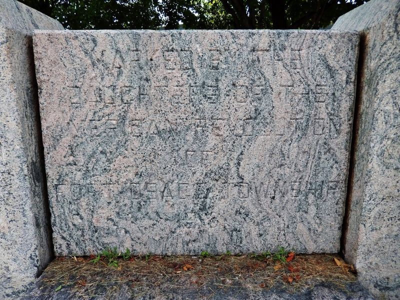
On East Monroe Street (U.S. 24) at North Buckner Tarsney Road (South Sibley Street), on the right when traveling east on East Monroe Street.
Government Reservation 1808
Marked by the Daughters of the American Revolution of Fort Osage Township 1918
Cross State Highway Buckner 1876 Jackson Co. Mo. — — Map (db m131967) HM
On Lexington Avenue near Main Street, on the right when traveling west.
A Century of Progress marks the development of Jackson County. In 1828 a log courthouse was built in Independence. In 1836 a brick building was erected as a permanent courthouse on this site. Soldiers returning from the Mexican War found an . . . — — Map (db m34898) HM
On Liberty Street near Lexington Avenue, on the right when traveling north.
This statue presented to the people of Jackson County by Harry S. Truman President of the United States, 1949.
Accepted for the people of Jackson County by the County Court.
Harry M. Gambel
Presiding Judge
Wm. J. Randall
Eastern . . . — — Map (db m34847) HM WM
On Mackville Hill Road (Kentucky Route 152) at Mackville Elementary School Drive, on the right when traveling east on Mackville Hill Road. Reported unreadable.
John Hunt Morgan and his men arrived in Mackville on Saturday evening, July 12, 1862, following raids on Lebanon and Springfield. Shortly after their arrival a skirmish ensued between Morgan’s men and the Home Guard. The Home Guard took two . . . — — Map (db m152653) HM
On Campbell Drive south of South Liberty Parkway, on the right when traveling south.
The Testimony of Eight Witnesses
Be it known unto all nations, kindreds, tongues, and people, unto whom this work shall come that Joseph Smith Jun. the translator of this work has shown unto us the plates of which hath been spoken. Which have . . . — — Map (db m311688) HM
On Shawnee Mission Parkway near Melrose Lane, on the right when traveling east.
The Santa Fe Trail went through two decades of change in the Kansas City area before evolving into it's final form by about 1840. In the early years of that decade it also became the route of the Oregon Trail and California Trail.
1821 - . . . — — Map (db m50679) HM
On Old East Lexington Road 0.4 miles east of U.S. 24 when traveling east.
Approximately 15,000 mounted troops of Confederate General Sterling Price's Army of Missouri, including guerilla leader George Todd, engaged 3,500 Union soldiers under the command of Major General James G. Blunt on the western bluffs of the Little . . . — — Map (db m252198) HM
On Lexington Avenue near Main Street, on the right when traveling west.
The Battle of Independence was fought at this and other locations on Aug. 11, 1862. On that day, a force of Confederate soldiers launched a dawn surprise attack on the Union garrison stationed at Independence and compelled it to surrender. It was . . . — — Map (db m34924) HM
Near West 103rd Street 0.1 miles east of State Line Road, on the right when traveling east.
For more than a century, a mill thrived on the banks of Indian Creek, supporting early Jackson County settlers and contributing to the growth of south Kansas City.
What would become widely known as Watts Mill bears the name of the family who . . . — — Map (db m251736) HM
On Main Street north of Earl Garrett Street, on the right when traveling north.
Kentucky native James Kerr, the son of a Baptist minister, was reared in Missouri. Kerr fought in the War of 1812 and was later sheriff of St. Charles County, Missouri. He married Angeline Caldwell in 1818 and served in the Missouri Senate and . . . — — Map (db m111223) HM
On Washington Street at West 7th Street, on the right when traveling north on Washington Street.
Henry Lee Jost was temporarily placed in the Five Points Mission by his father after the death of his mother in approximately 1879. After his family failed to pay the orphanage boarding fees, Henry became a ward of the facility and was placed out . . . — — Map (db m185993) HM
You are standing on the Arrow Rock bluff, where the Missouri River formerly made a bend. For generations, the Missouri River served as the great water highway of the West.
The Arrow Rock bluff was a significant landmark for American Indians, . . . — — Map (db m246859) HM
On Buckner-Tarsney Road, on the right when traveling north.
Four miles north are restored buildings of Fort Osage, westernmost frontier outpost of the U.S. government until 1819. One of 28 fortified Indian trading posts or "factories" operation on our Indian frontiers, 1795-1822, to promote and protect . . . — — Map (db m90355) HM
On Central Street at 9th Street, on the right when traveling north on Central Street.
The Savoy Hotel was constructed between 1890 and 1906 during a building boom which created some of the most architecturally significant buildings in the central business district. The first major hotel enroute from the old Union depot, it served as . . . — — Map (db m19831) HM
On East Main Street just east of North Washington Street (Missouri Highway 13).
The fertile Shoal Creek Valley, Kingston was laid out in 1843 to replace Far West as seat of Caldwell County. Organized in 1836, the county was to be for Latter Day Saints (Mormons), ejected from Jackson County in 1833 and asked to leave Clay . . . — — Map (db m144715) HM
The town was only a spark in 1834 when entrepreneur and tradesman John Calvin McCoy cut a primitive path from this store to a prominent rock ledge on the river – a perfect landing for riverboats. The steamboat John Hancock, laden with . . . — — Map (db m87450) HM
On North Central Avenue south of East Wood Street, on the left when traveling south.
In 1834, Joseph Smith, prophet of the Church of Jesus Christ of Latter-Day Saints (LDS), together with about 200 LDS Volunteers from Kirtland, Ohio, marched to assist threatened church members in Jackson County, Missouri. Called “Zion’s . . . — — Map (db m23351) HM
On North Lorimier Street south of Broadway Street, on the left when traveling south.
The coming of the machine age had little effect on the production of faience tiles. After eight centuries of producing faience, man has had little success in changing the methods of producing beautiful pieces of timeless durability. So when the . . . — — Map (db m236238) HM
This historic aviation facility is named in honor of longtime medical pathologist, Jackson County coroner, judge, and Mayor of Kansas City, Missouri, Charles B. Wheeler. In appreciation of his dedication to air service expansion for the people of . . . — — Map (db m58406) HM
Near Missouri Route 5 at Katy Trail, on the right when traveling south.
Josiah Gregg was born in Overton County, Tennessee – the youngest son of Harmon and Susannah (Smelser) Greggs' seven children. In 1812 his family settled at Cooper's Fort in Howard County, and later moved to Jackson County. Sickly, shy and studious, . . . — — Map (db m252443) HM
On 123 SE 3rd Street, on the right when traveling east.
"In the Lee's Summit Veterans Memorial Building, which stood at this site, Harry S. Truman, 33rd president of the United States first declared his candidacy for an elective political office. Here on March 7, 1922 Truman agreed to become a candidate . . . — — Map (db m91097) HM
On Gulf Street at 11th Street West, on the right when traveling north on Gulf Street.
Side A
Lamar is distinguished as the birthplace of Harry S. Truman, the 33rd President of the United States. The son of John Anderson Truman and Martha Ellen (Young) Truman, he was born May 8, 1884. The family moved to Harrisonville in Cass . . . — — Map (db m42286) HM
On Delaware Street at U.S. 24, on the left when traveling north on Delaware Street. Reported missing.
Side A:
Independence, famed "City of the Trails," was for two decades the starting point of the great western trade and travel routes to Santa Fe, Oregon, and California. Settled mainly by Southerners on land ceded the U.S. by the Osage . . . — — Map (db m44323) HM
On Hickman Mills Drive west of Marion Park Drive, on the right when traveling north.
The shared corridor of three major trails-the Santa Fe, Oregon, and California-once passed this way. Here on Hart Grove Creek, trail travelers stopped for water, wood, and a night's rest. Within a day's walk to the west was the Missouri state . . . — — Map (db m245098) HM
Erected by G. G. Gage
to the memory of
his comrades who fell at
The Battle of the Blue.
Oct. 22, 1864.
By the blood of these heroes, and
their compatriots, this great
Republic was made to live
2nd Regiment K. S. M.
from . . . — — Map (db m47339) WM
On Main Street north of East 2nd Street, on the right when traveling north.
On June 26, 1804 the Lewis & Clark Expedition known as President Jefferson's Corps of Discovery passed this place on their way west.
In 1825, treaties with the Kaw and Osage Indians opened up for settlement an area between Fort Osage to the . . . — — Map (db m252086) HM
On State Highway 77 at milepost 3, 0.6 miles east of 1700 S. Road, on the right when traveling east.
This shortcut to the California goldfields, followed by most of the 49'ers, came out of the hills to the east and joined the old California trail just about here.
Opened by "Messrs. Hudspeth & Myers, of the Jackson County, Missouri, . . . — — Map (db m31638) HM
On SE Main Street north of SE 3rd Street, on the left when traveling north.
This park, named for the founder of the city of Lee's Summit, is located on the original depot grounds which were set aside for railroad use when the town of Strother was platted on October 28, 1865. The town of Strother was later incorporated as . . . — — Map (db m80718) HM
Near Northwest 87th Terrace east of Northwest 88th Street/Northwest Old Stagecoach Rd, on the left when traveling east. Reported missing.
Founded in 1829 during Andrew Jackson's presidency, this frontier town was named for Postmaster General William Taylor Barry. Marking the midpoint of the new Military Road between Liberty and Fort Leavenworth, the town played an important role in . . . — — Map (db m252141) HM
On South Main Street at Water Street, on the right when traveling north on South Main Street.
The overland route linking St. Charles with the future sight of Fort Osage in present-day Jackson County was likely the earliest trail used by American settlers heading west. On its eastern end the trail passed in the vicinity of the later towns of . . . — — Map (db m124814) HM
Near Evergreen Street, on the right when traveling south.
James Williams
California Pioneer
James Williams, age 29 and a native of Cape Girardeau, Missouri, emigrated overland to California in 1843 along with his three brothers – John, age 25; Isaac, age 20; and Squire, age 19 – in a . . . — — Map (db m62440) HM
On Old U.S. 40 west of Route D, on the right when traveling west.
Williamsburg and its rural neighborhood, including the Loutre River valley to the east, were home to several famous, even notorious Southern guerrillas.
One such was Capt. Alvin Cobb of "Cobbstown," in western Montgomery County, Mo. A large, . . . — — Map (db m212623) HM
On South River Boulevard south of West Lexington Avenue, on the right when traveling south.
August 3, 1831, Joseph Smith, Jr., Prophet and Founder of the Church of Christ, with seven other Church leaders, dedicated this site for the Temple in the City of Zion, where this Church believes the Lord will come to His people in the Last Days. — — Map (db m156377) HM
On East 99th Street east of Holmes Road, on the right when traveling west.
Public/private partnerships preserve three National Historic Trails in south Kansas City, highlighting 19th century exploration and migration that shaped the nation. In the heart of the historic 3-Trails Corridor, the Trailside Center at East . . . — — Map (db m199522) HM
Near East 63rd Street west of Manchester Trafficway, on the right when traveling west.
The Battle
When Confederate Maj. Gen. Sterling Price entered Jackson County, he commanded an army of around 12,000 troopers. He had amassed a train of around 500 wagons loaded with plunder and war supplies. As Price had marched across . . . — — Map (db m258395) HM
Near U.S. 67 2 miles south of County Road 221, on the right when traveling south.
U.S. Senate candidate Harry S Truman visited Greenville on October 2, 1934, during a campaign swing through southeastern Missouri. Her gave speeches that day along U.S. Route 67 at the county courthouses in Fredericktown, Greenville, and Popular . . . — — Map (db m187284) HM
Born May 8, 1884
Lamar, Missouri
Died December 26, 1972
Married June 28, 1919
Daughter
Born February 17, 1924
Judge
Eastern District
Jackson County
Jan. 1, 1923 - Jan 1, 1925
Presiding Judge
Jackson County
Jan. 1, 1927 - . . . — — Map (db m58843) HM
On West College Street at North McCoy Street, on the right when traveling west on West College Street.
The Santa Fe Trail began in 1821 when William Becknell took trade items west and found a ready market in Mexico. He passed through this area before the village of Independence was platted in 1827 as the county seat for newly formed Jackson County. . . . — — Map (db m208242) HM
On East Red Bridge Road, on the right when traveling east.
John Calvin McCoy (1811-1889), an enterprising young surveyor, built a two-story log trading post in the hills four miles south of the Missouri River in 1833. Later known as Westport, it became a trading and outfitting center for traders, fur . . . — — Map (db m199448) HM
On East Red Bridge Road, on the right when traveling west.
(This marker has two panels. From the left panel:)
Key Map
Traveling across this bridge, the fourth Red Bridge near this location since 1859, you may notice art panels attached to each of the large pillars that rise at both . . . — — Map (db m210568) HM
On Broadway (Missouri Route 224) at Highland Avenue, on the right when traveling west on Broadway.
Madonna of the Trail Monument
The "Madonna of the Trail" statue was designed and sculpted by August Leimbach of St. Louis. The statue was unveiled and dedicated on September 17, 1928 by the Missouri State Society Daughters of the . . . — — Map (db m241047) HM
On Heritage Landing south of South St. Peters Parkway, on the right when traveling north.
Cribbin's Home
• This park, historically known as the Cribbin's Home, Kuhlmann's Grove, and even Cedar Grove in 1875, features a well-known home built in the mid-1800s.
• The home was built by Lawrence Cribbin (sometimes spelled . . . — — Map (db m150854) HM
Near West Lexington Avenue just west of South Bowen Street, on the right when traveling west.
Built by the Stallcup family in the early 1830s, this structure was initially located about five miles east of its present location. Frederick Madison Smith acquired the property in 1937. Born in 1872 in Plano, Illinois, he was the grandson of . . . — — Map (db m156380) HM
On Westridge Road 0.2 miles north of East Bannister Road, on the left when traveling north.
Earliest grave
Isaac Flanery, 1841
Last Recorded Grave
Andrew Jackson Frost, 1928
This one acre wooded glade is the resting place of approximately 25 early pioneers of the Raytown, Jackson County, Missouri area and several Union soldiers . . . — — Map (db m91100) HM
On N Ambassador Drive at Cookingham Drive, on the left when traveling east on N Ambassador Drive.
In 1931 Emmett Breen built Red Crown Tavern and Tourist Cabins west of here.
On July 19, 1933, Platte County Sheriff Holt Coffey led a coalition of lawmen from the Platte County Sheriff's Office, Missouri Highway Patrol and the Jackson . . . — — Map (db m64391) HM
Near Hardesty Avenue north of 63rd Street, on the left when traveling north.
In the frosty darkness of the early pre-dawn hours of October 22, 1864, 300 citizen soldiers of the 4th Kansas State Militia crossed over Byram's Ford here. They encamped on the west side in a nearby cornfield on the opposite high bank. The . . . — — Map (db m187215) HM
On Chiefs Way at Red Coat Lane, on the right on Chiefs Way.
The Jackson County Sports Complex Authority was established in 1967 as a political subdivision of the State of Missouri to serve as the landlord between Jackson County and the Kansas City Royals and the Kansas City Chiefs. Construction began in the . . . — — Map (db m118948) HM
On West College Street at North McCoy Street, on the right when traveling west on West College Street.
Being at leisure one day, I rode over to Independence [from Westport, in May 1846]. The town was crowded. A multitude of shops had sprang up to furnish the emigrants and Santa Fe traders with necessaries for the journey; and there was an . . . — — Map (db m208146) HM
On Lexington Avenue near Main Street, on the right when traveling west.
Revolutionary Soldiers
Lt. Joseph Boggs, PA. • William Moore, VA.
Isaac Drake, MD. • Ledston Noland, N.C.
——————
Fort Osage, 1808-1827
Major George C. Sibley, U.S. Indian Agent
Mary Easton . . . — — Map (db m34857) HM
Originally known as Ottawa, 12th Street spanned from the West Bottoms, nestled in the confluence of the Kansas and Missouri rivers, to the eastern suburbs, dotted by small bungalows. At first a colorless retail strip, 12th Street blossomed into an . . . — — Map (db m200146) HM
1803 The Louisiana Purchase
1804 Lewis and Clark Explore
1808 They build Fort Osage - Osages cede lands to the east
1809 Troops to the Mandans
1811 Astorians to the Pacific - Sibley visits Kaws and Pawnees
1812 War with Great Britain . . . — — Map (db m86562) HM
On Pennsylvania Avenue at Westport Road, on the right when traveling north on Pennsylvania Avenue.
Price's Raid
Confederate General Sterling Price brought three mounted divisions from Arkansas into Missouri, September 19, 1864. Fighting several small battles he marched slowly north toward St. Louis, then struck westward to Jefferson City. . . . — — Map (db m20868) HM
On West Franklin Street near 2nd Street when traveling west.
(side one)
Few sermons have ever struck Jackson with the force of one delivered
in the Congregational Church on Oct. 13, 1850. There, the Reverend
Gustavius Foster preached from Titus 3:1, “Put them in mind to be
subject to . . . — — Map (db m256872) HM
Thin black lines indicate changes in relevance. Between each pair of lines entries are ordered geographically but all have the same relevance.
* Inflectional forms of words are their plurals, singulars, and possessives as well as gramatical tenses and similar variations.