By Duane and Tracy Marsteller, November 14, 2020
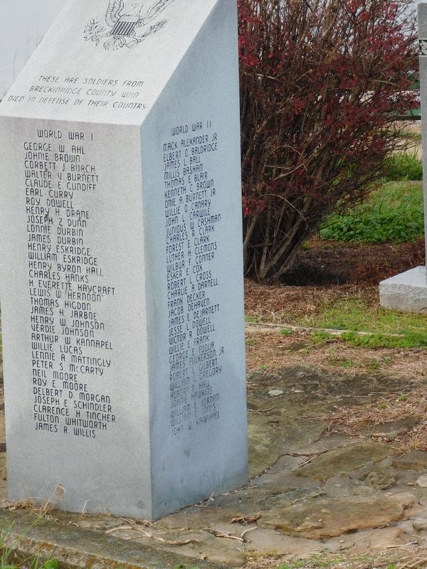
Breckinridge County Veterans Memorial
GEOGRAPHIC SORT Title Sort Marker Number Sort Marker Number Sort for Trails Publication Order Sort Publication Order Sort A Erected Year Sort Most Viewed Sort Most Recent-Interest Sort Most Recently Changed Sort SEE FAQ #33 FOR DESCRIPTIONS
On West Main Street (State Road 2200) at Center Street, on the right when traveling west on West Main Street.
Near Elm Street north of West Main Street.
On West Front Street west of Elm Street, on the left when traveling east.
On West Front Street west of Elm Street, on the right when traveling east.
On West Front Street west of Elm Street, on the right when traveling east.
On West Front Street west of Elm Street, on the right when traveling east.
On Elm Street north of West Main Street, on the right when traveling north.
On Elm Street north of West Main Street, on the right when traveling north.
On West Main Street (State Road 2200) at Center Street, on the right when traveling west on West Main Street.
On West Main Street (State Road 2200) at Oak Street, on the right when traveling west on West Main Street.
On West Main Street (Kentucky Route 2200) east of Center Street, on the right when traveling west.
On West Main Street (Kentucky Route 2200) at Center Street, on the right when traveling west on West Main Street.
On West Street at Verden Street, on the right when traveling west on West Street.
On Blacklick Church Lane west of Rockvale Road ( Route 629), on the right when traveling west.
On South Main Street at East 2nd Street (Business U.S. 60), on the right when traveling south on South Main Street.
Paid Advertisement
On 2nd Street (Business U.S. 60) at South Main Street ( Route 261), on the right when traveling east on 2nd Street.
On 2nd Street (Business U.S. 60) west of South Main Street ( Route 261), on the right when traveling east.
On South Main Street at Court Square, on the right when traveling south on South Main Street.
On U.S. 60 at Road 144, on the right when traveling west on U.S. 60.
On State Road 144, on the right when traveling south.
On State Road 144, on the right when traveling west.
On State Road 144, on the right when traveling south.
On South Main Street (State Road 261) 0.1 miles south of FFA Camp Road, on the left when traveling south.
On North Main Street (State Road 259), on the right when traveling north.
On U.S. 60 0.5 miles east of Low Dowell Road, on the left when traveling east.
On Kentucky Route 144 0.2 miles west of Knottsville St Lawrence Road.
On Bolling Heights Lane 0.1 miles north of Road 2116, on the right when traveling north.
On U.S. 60 1.2 miles east of Kelly Cemetery Road, on the right when traveling east.
On Locust Street north of West 7th Street, on the right when traveling north.
On Airport Road (State Road 2118), on the right when traveling east.
On Road 144 at Yellow Creek Park, on the right when traveling east on Road 144.
Paid Advertisement
On West Veterans Boulevard at Frederica Street, on the right when traveling west on West Veterans Boulevard.
Near West 5th Street at Cs-1186-30, on the right when traveling west.
On West 10th Street at Frederica Street ( Road 2831), on the left when traveling east on West 10th Street.
On West 3rd Street at Frederica Street, on the right when traveling west on West 3rd Street.
On West 2nd Street west of St Ann Street, on the left when traveling west.
On West 2nd Street east of Frederica Street, on the left when traveling west.
On St Ann Street south of West 2nd Street, on the left when traveling north.
On New Hartford Road (U.S. 231) just south of Spring Bank Drive, on the right when traveling north.
On West 4th Street at Poplar Street, on the right when traveling east on West 4th Street.
On River Road (State Road 331), on the right when traveling north.
On East 7th Street at Crittenden Street, on the right when traveling west on East 7th Street.
On West 4th Street east of Poplar Street, on the left when traveling east.
On West 3rd Street west of St Ann Street, on the right when traveling west.
On State Road 2830 0.1 miles north of Ellis Smeathers Road (County Road 1091), on the right when traveling north.
On Daviess Street north of East 4th Street, on the right when traveling north.
On State Road 405 0.4 miles north of Wrights Landing Road (State Road 1831), on the left when traveling north.
Paid Advertisement
On West 5th Street at Cs-1186-30, on the right when traveling west on West 5th Street.
On State Highway 56 at Hayden Bridge Road (State Highway 279), on the right when traveling west on State Highway 56.
On Frederica Street south of West 2nd Street, on the right when traveling north.
On West 7th Street at Walnut Street, on the right when traveling west on West 7th Street.
On West 2nd Street at Frederica Street, on the left when traveling west on West 2nd Street.
On West 5th Street at Ewing Court, on the right when traveling west on West 5th Street.
On Locust Street just south of West 5th Street, on the right when traveling south.
On Woodford Avenue 0.1 miles north of Herr Avenue, in the median.
On Bittel Road at Dallas Avenue, on the right when traveling west on Bittel Road.
On Frederica Street (State Road 2831) at Maple Avenue, on the right when traveling south on Frederica Street.
On Griffith Avenue at Mccreary Avenue, on the right when traveling east on Griffith Avenue.
Near West 5th Street at Cs-1186-30, on the right when traveling west.
Near West 5th Street at Cs-1186-30, on the right when traveling west.
On Frederica Street (State Road 2831) at West 11th Street, on the right when traveling north on Frederica Street.
On West 3rd Street at St Ann Street, on the right when traveling west on West 3rd Street.
On State Highway 142 at Millers Mill Road (State Highway 762), on the right when traveling north on State Highway 142.
Paid Advertisement
On U.S. 431 at Sharp Road, on the right when traveling south on U.S. 431.
On Kentucky Route 764 just south of U.S. 231, on the right when traveling north.
On U.S. 431 at Sharp Road, on the right when traveling south on U.S. 431.
On Ward Road at East Millerstown Road ( Route 224), on the right when traveling north on Ward Road.
On Jenny Green Road at Green Farm Road, on the right when traveling south on Jenny Green Road.
On Falls of Rough Road (State Road 79) at Robinson Road, on the right when traveling south on Falls of Rough Road.
On Grayson Springs Road west of Western Kentucky Parkway, on the right when traveling west.
On Public Square at North Main Street (U.S. 62), on the left when traveling south on Public Square.
On Public Square at East Main Street, on the left when traveling north on Public Square. Reported missing.
On Public Square at West Main Street, on the left when traveling south on Public Square.
On Public Square at West Main Street, on the left when traveling south on Public Square.
On Public Square at West Main Street, on the left when traveling south on Public Square.
On Grayson Springs Road (Kentucky Route 1214) west of Route 88, on the right when traveling east.
On East Main Street at South Clinton Street, on the right when traveling east on East Main Street.
On South Clinton Street at East Main Street, on the right when traveling south on South Clinton Street.
On Elizabethtown Road (U.S. 62) at Shaw Station Road, on the right when traveling west on Elizabethtown Road.
Paid Advertisement
On Indian Lake Drive (State Road 3199) at Scenic Hilltop Road, on the right when traveling west on Indian Lake Drive.
On U.S. 60 at Jennings Street, on the right when traveling north on U.S. 60.
On Main Street (Kentucky Route 69) at Madison Street ( Route 69), on the right when traveling south on Main Street.
On State Road 1389 at Franklin Gaynor Road, on the right when traveling east on State Road 1389.
On Main Street at Washington Street, on the right when traveling north on Main Street.
On River Street north of Bridge Street, on the right when traveling north.
On State Road 3543 north of U.S. 60, on the right when traveling north.
On State Road 144 at Quisenberry Road, on the right when traveling east on State Road 144.
On 4th Street at Pell Street ( Road 334), on the right when traveling south on 4th Street.
On River Road (State Road 334) 0.5 miles south of Adair Road (State Road 1605), on the right when traveling south.
On 4th Street north of New Front Street when traveling north.
On State Road 144 at State Road 2181, on the right when traveling west on State Road 144.
On U.S. 62 0.1 miles east of South Main Street, on the right when traveling west.
On South Lee Trover Todd Jr Highway (U.S. 41) at West Main Street (State Route 112), on the left when traveling north on South Lee Trover Todd Jr Highway.
On North Mc Euen Avenue (Kentucky Route 1337) north of County Route 3057, on the right when traveling north.
On Hanson Road (U.S. 41) at Eastlawn Road (State Route 260), on the right when traveling north on Hanson Road.
Paid Advertisement
On Stagecoach Road (Kentucky Route 1069) north of Tippett Road, on the left when traveling north.
On Sunset Road (Kentucky Route 260) 0.1 miles west of Hanson Road (U.S. 41), on the right when traveling west.
On West Arch Street at North Spring Street, on the left when traveling west on West Arch Street.
On South Franklin Street at Hall Street, on the right when traveling south on South Franklin Street.
On Union Street at Hall Street, on the right when traveling north on Union Street.
︽
182 entries matched your criteria. The first 100 are listed above.
The final 82 ⊳