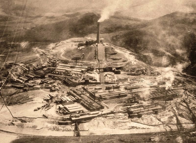
On September 29, 1980, the Anaconda Minerals Company, which had merged with the Atlantic Richfield Company (ARCO) three years earlier, announced the indefinite suspension of copper smelting in Anaconda and refining in Great Falls, Montana. The . . . — — Map (db m128127) HM
Contractor John Jacobson built this brick store and boardinghouse in 1915, during a time of rapid commercial and residential expansion in Anaconda. Downtown Anaconda property owners developed every square foot of their lots during this boom, . . . — — Map (db m183521) HM
This sign was dedicated in fall 2010 to the purpose and goals of the Silver Creek environmental cleanup.
• Remedial cleanup covers 22 stream miles of Silver Bow Creek, extending from Butte to the Warm Springs Ponds.
This work is funded from . . . — — Map (db m183608) HM
Extracting pure copper from the ores mined in Butte was a complex process. First, the useless waste rock was separated from the valuable ore, and the high-grade material was separated from the low-grade material. Next, the lower-grade ore was . . . — — Map (db m128132) HM
Dr. Felix L. St. Jean and brick mason Joe Cosgrove commissioned local architect Herman Kemna to design this building in 1893. Though later owners remodeled the first-floor façade and renamed the building, the second story remains among the best . . . — — Map (db m183526) HM
Anaconda grew quickly after Copper King Marcus Daly established it as his smelter town in 1883, but the community’s Episcopalians needed to wait seven years before they could lay the cornerstone for St. Mark’s Episcopal Church on October 21, 1890. . . . — — Map (db m205796) HM
The mountains surrounding this valley began to form more than 100 million years ago when tectonic forces compressed the earth's crust and forced layers of underlying sedimentary rock eastward along great thrust faults. The faults stacked flat slices . . . — — Map (db m183612) HM
The well-preserved Thorsen Brothers Grocery building is a classic example of an early-twentieth-century commercial building. The decorative brick parapet made the building look larger and offered ample room for signage, while tall display windows . . . — — Map (db m183455) HM
Mass production of decorative details allowed even modest houses to partake of architectural fashion. In the case of this one-and-one-half-story home, stained glass, gingerbread and latticework, turned porch supports, and fish-scale shingles in the . . . — — Map (db m205808) HM
An architecturally impressive landmark and gateway to Anaconda’s east side, the Washoe Brewery symbolizes the private enterprise that flourished in this company town. The imposing Italian Renaissance-inspired brewery with its signature corner tower . . . — — Map (db m205886) HM
During the early years of smelting in Anaconda, each of the many furnaces at the Old Works required its own stack. Later the individual stacks were connected through flues to a large central stack.
When constructed in 1902, the first Washoe . . . — — Map (db m128130) HM
Seattle-based theater architect B. Marcus Pinteca (1890-1971) drew the plans for this remarkable structure in 1930. However, the Depression delayed interior finishing and the $200,000 movie theater did not open until 1936. The Washoe Theater and . . . — — Map (db m180981) HM
In October 1900, German tailors William Weiss and John Zilinsky invested in this commercial building. They paid an exorbitant $9,500 for three lots behind Marcus Daly’s bank, where they constructed the first story of this two-story building. Early . . . — — Map (db m183528) HM
401 East 3rd Street, Anaconda, Montana
Rapidly increasing demand for copper ore in the 1890s brought an influx of more than 5,000 new residents to the Smelter City between 1890 and 1900. To house them all, a fleet of carpenters built hundreds of . . . — — Map (db m205715) HM
Architect Jonathon Barlett designed this marvelous business block as an investment property for T. C. Davidson in 1896. Davidson, an Ohio native and Civil War veteran, came to Montana in 1879. In the early 1890s, Davidson moved from his nearby ranch . . . — — Map (db m183395) HM
After attending Fisk University in Tennessee, Lee Pleasant Driver enlisted in the Twenty-fifth U.S. Colored Infantry in 1888. The twenty-five-year-old private, who soon advanced to corporal, served at Forts Keogh (Miles City) and Missoula. He was . . . — — Map (db m180975) HM
About 350 million years ago, much of Montana was submerged under a shallow sea. Billions of tiny marine creatures thrived in the water and when they died their bodies settled into the muck on the sea bed. After hundreds of millions of years of . . . — — Map (db m71505) HM
The limestone feature (outcrop), located across the road, known as the Madison Limestone Formation, was deposited about 350 million years ago in a shallow sea. It was uplifted about 65 million years ago during the Laramide Orogeny (when the Rocky . . . — — Map (db m80318) HM
This certificate officially recognizes
Union Peak Lookout,
Granite County, Montana,
as meeting those standards of historic and cultural significance
established by the American Resources Group, Washington,
D.C., in cooperation with the . . . — — Map (db m301256) HM
The Flint Creek Valley has, according to archeologists, been the home to humans for around 10,000 years. Fur trappers and traders frequented the valley in the early 19th century. Prospectors discovered gold in the Granite Mountains and on . . . — — Map (db m212347) HM
Before his death in 1896, pioneering Jewish businessman William Weinstein owned many lots, including this one, in Philipsburg. By 1902, his daughter Alice Weinstein Hannah owned the property and the one-story wooden dwelling that stood on the site, . . . — — Map (db m205462) HM
Local rancher Lee Degenhart financed the construction of this building in 1910. Fred Haverty, a contractor from Hal, Montana, who later ran a car dealership here in Philipsburg, was the builder. Design features include the original ornamental leaded . . . — — Map (db m45224) HM
The tramway was constructed in 1889 to carry ore from the Blaine Shaft in Granite to the Bi-Metallic Mill in Kirkville, near Philipsburg. The Bi-Metallic aerial tramway was 9750 feet long with a vertical drop of 1225 feet, and was the longest aerial . . . — — Map (db m49547) HM
Built circa 1887, Lutey's Grocery and the Barrett and Jacky Harness Shop originally shared occupancy of this one-story commercial building. By the 1890s, Valentine Jacky shared this building with C. T. Huffman who supplied groceries to Philpsburg . . . — — Map (db m45226) HM
Brothers Morris and Humphery Courtney built this multi-purpose building in 1918 with the profits from manganese mining acquired during World War I. The building speaks to the coming of the automobile as the basement housed the Granite County Garage . . . — — Map (db m49371) HM
In the 1880s and 1890s, masonry structures gradually replaced the frame buildings left from Philipsburg’s mining camp days. Doe and Hoyer constructed this commercial brick building in 1887. Modini’s Grand Hotel and Restaurant was located in the west . . . — — Map (db m205451) HM
Reverend Milton Cook organized Philipsburg’s first Presbyterian congregation in 1877 and Reverend George Edwards came from Missoula to preach once a month. But it was not until 1891 that Reverend Samuel Wishard established a permanent Presbyterian . . . — — Map (db m205541) HM
The first permanent home for Granite County offices was completed in 1913. Prominent Montana architects John Link and Charles Haire designed the building. Its cut stonework is, appropriately, made of Montana granite. Granite County commissioners . . . — — Map (db m45229) HM
The Granite County Jail was constructed in 1896, three years after Granite County was carved from two adjacent counties and Philipsburg made the county seat. The town served as a hub to extensive area mining and, later, ranching. The jail was the . . . — — Map (db m45228) HM
Granite Mtn. Mine located July 6, 1875 and operated by the Granite Mtn. Company.
A rich silver bonanza shoot was discovered in Nov. 1882. The mine closed in 1893 and reopened again in 1911 and 1912 and operated for a brief time. — — Map (db m49540) HM
This two-story building, constructed in about 1885, was one of the first structures in Granite, and housed the brick vault that is seen here. The mining office handled the payroll for the men who worked at the Ruby Shaft and the two mills on the . . . — — Map (db m49629) HM
The excellent design and spacious interior of this two-story commercial building represents Philipsburg’s prosperity and substantial population during the 1890s. Constructed for J.K. Merrill and Sons between 1892 and 1894, Freyschlag Huffman and . . . — — Map (db m49370) HM
In July 1878, a band of Nez Perce Indians returning south from Canada after eluding U.S. Cavalry, crossed what is now Granite County. While passing through they attacked a small mining camp located on a tributary of Rock Creek at McKay Gulch. Three . . . — — Map (db m45211) HM
Michael Kaiser, founder of Philipsburg Water Company, built this grand hotel in 1881. One of Philipsburg's oldest masonry structures, the original hotel boasted a wrap-around porch extending halfway around the building. Second-story French doors, . . . — — Map (db m45218) HM
Meetings in Philipsburg of Flint Creek Lodge No. 11 date back to 1867. This structure, built in 1911, provided a permanent home for the community-oriented fraternal organization. Chambers for lodge meetings occupy the entire top floor. The ground . . . — — Map (db m45222) HM
Prominent businessman Angus A. McDonald constructed this two-story masonry theater in 1891. A metal-covered stage loft rises above the roof as evidence of the structures historic function. Beneath the south end were dressing rooms for the traveling . . . — — Map (db m49373) HM
The Granite Mountain Mining Company constructed two mills adjoining the mining operation know[n] as the Ruby Shaft. These structures, Mill A and Mill B, housed a total of 70 stamp mills which processed ore. Stamp mills were used to crush the ore so . . . — — Map (db m49631) HM
Built in 1890 at a cost of $23,000, this three-story building was once the social center of a bustling mining town. The first floor was constructed of native granite. The cast iron front held 6 large windows and small colored glass panes. The upper . . . — — Map (db m49628) HM
Colonel J.W. Morse built Morse Hall in 1887. This elaborately detailed public lecture hall also served as county courthouse after 1893, an opera house, town hall, library and general community center. Its splendid second story dance floor was the . . . — — Map (db m45213) HM
During the 1880s masonry structures began to replace wood-framed buildings from the mining camp days to form the present town. George H. Harn, who at that time ran one of two local brickyards, probably built this fine residence with his own bricks. . . . — — Map (db m205544) HM
Philipsburg's early-day fortunes ebbed and flowed with mining. Today, its historic district is one of Montana's best preserved late-19th-century mining towns, with commercial, public and private buildings dating from the boom period of silver . . . — — Map (db m45209) HM
Philipsburg's early-day fortunes ebbed and flowed with mining. Today, its historic district is one of Montana's best preserved late-19th-century mining towns, with commercial, public and private buildings dating from the boom period of silver . . . — — Map (db m45210) HM
One of a network of Jewish merchants who supplied miners in the Rocky Mountain West, nineteen-year-old Benjamin Pizer arrived in Helena from Poland with his wife Jessie Silverman and their newborn son David in 1869. With limited capital, he . . . — — Map (db m45217) HM
Most of the ore that brought tremendous riches and fame to Granite was brought out of the Ruby Shaft, operated by the Granite Mountain Mining Company. Several tunnels outside the Ruby Shaft were also important in producing the silver (and some gold) . . . — — Map (db m49544) HM
First known as the Hyde Block, this building was constructed by banker Joseph Hyde and his wife, Mary, in 1888. It housed the First National Bank until the silver crash of 1893. In 1904, Frank Sayrs purchased the building and it has since held a . . . — — Map (db m45220) HM
A beautifully embellished pedimented gable and open porch with spindled balustrade, turned columns, and decorative details highlight this splendid two-and-one-half-story Queen Anne style residence of salmon-colored brick. Mary Schuh, a longtime . . . — — Map (db m205543) HM
In January 1889, St. Andrew’s Episcopal Church opened its doors to hold one of the first services in a church in Philipsburg. Placed within the cornerstone the previous year were a Bible, some coins, names of donors, and a copy of the Philipsburg . . . — — Map (db m205457) HM
The cornerstone for St. Paul’s Methodist Episcopal Church was laid in 1887. Dedicated September 15, 1890, this modest but rather sophisticated structure was one of Philipsburg’s early churches. Choice of brick and prolonged construction reveal the . . . — — Map (db m205459) HM
By 1899, this house stood at the head of Magnolia Avenue, or “Silk Stocking Row,” where the elite of Granite lived. The first floor housed the living quarters for the Superintendent of the Granite Mountain Mining Co. The second floor may . . . — — Map (db m49545) HM
Around the mountain from the mining camp of Cable in 1866 came Polish-born merchant William Weinstein with a wagon-load of goods to sell. He became Philipsburg's first general merchant, constructing the eastern half of this building in the late . . . — — Map (db m45212) HM
Charles A. and Frank J. Wilson, brothers from Wisconsin, built and established their businesses in this building by 1888. The building originally housed a furniture store on one side, a feed store on the other and a miners' boarding house/living . . . — — Map (db m45214) HM
Prominent Missoula architect A. J. Gibson designed and built this two-story commercial building in 1905. The fine design includes a metal modillioned cornice and panels with a full height glass storefront and polished granite skirt below. The Walker . . . — — Map (db m45223) HM
The Hope, Katy and White Elephant mines behind this sign were once part of the most productive mining enterprise in the history of the Basin. The Hope and Katy lodes produced $5,000,000 of ore between 1890 and 1910. On April 20, 1895, the Blast . . . — — Map (db m186124) HM
This is about the center of a rich mining district extending from Butte to Helena. The mountains are spurs of the Continental Divide.
Ghost and active mining camps are to be found in almost every gulch. The ores yield old, silver, copper , lead . . . — — Map (db m186119) HM
For centuries Native Americans have been coming to these pure, flowing hot water springs for rest and healing. Legend tells that they called this area Peace Valley. They agreed to lay down their weapons when they sojourned here, believing that the . . . — — Map (db m186201) HM
Originally this site, now named Boulder Hot Springs, was known only to Nomadic Indians during yearly mountain crossings. The waters bubble out of the mountains just south of here at temperatures ranging from 120 to 182 degrees and are known . . . — — Map (db m186245) HM
In 1888, Jefferson County voters passed a $40,000 bond issue to build a permanent courthouse. Flourishing gold and silver mines and the advent of the railroad meant the county would see its population quadruple between 1870 and 1890, and there . . . — — Map (db m186193) HM
Montana pledged its commitment to children with disabilities in 1887 when Territorial Governor Preston Leslie requested funds for a Montana Deaf and Dumb Asylum. Its title, although shocking by today’s standards, reflects accepted nineteenth-century . . . — — Map (db m186195) HM
The trusses on this structure were salvaged from the "Hubbard" or "Red" Bridge. The original structure was built by the Gillette-Herzog Manufacturing Company in 1899. The company was one of several Minnesota-based bridge construction firms active in . . . — — Map (db m186202) HM
Swiss miner Peter Wys discovered the lucrative silver veins of the Elkhorn Mine that would eventually yield $14 million. After Wys died in 1872, Helena entrepreneur Anton M. Holter and partners developed the Elkhorn Mine. Holter sold out to an . . . — — Map (db m290533) HM
On August 1st, 1805, William Clark celebrated his 35th birthday by shooting a bighorn sheep as he passed through the Jefferson River Canyon.
When the Corps of Discovery explored this area, bighorn sheep were common here. Later in the century . . . — — Map (db m141644) HM
In August 1840, Pierre Jean De Smet, a Catholic missionary of Belgian birth, camped near the mouth of the Boulder River with the Salish Indians and celebrated the holy sacrifice of the Mass. Father De Smet left the Indians soon after to go to St. . . . — — Map (db m128362) HM
Today as you travel in Lewis and Clark Caverns State Park you are likely to see mule deer, signs of elk and perhaps a black bear. This terrain was suitable for wildlife but when Lewis and Clark passed here in 1805 and 1806, these potential food . . . — — Map (db m141648) HM
On August 1, 1805, the Lewis and Clark Expedition camped at a point 200 yards west from this spot on the south bank of the river facing the mouth of the creek which flows into the river from the north. Meriwether Lewis and three others, on a . . . — — Map (db m128371) HM
This is the former site of the Lewis and Clark Caverns Park Entrance Building, a simple A-frame which welcomed visitors to the park for over fifty years.
In 1939, park management began plans to build a greeting center and caretaker residence . . . — — Map (db m141650) HM
In 1868 the first mine was started in the Elkhorns. A.M. Holter, a Virginia City pioneer, started the Elhorn Mine in 1875. by February of 1888 the mine was producing $30,000 worth of ore monthly.
As the mine developed during the 1870's the . . . — — Map (db m290524) HM
The story of the Elkhorn Mountains Volcanics and the Boulder Batholith is the short of how molten magma or melted rock rising up through the crust of the earth just kept coming and coming and coming - from about 81 to about 74 million years ago. . . . — — Map (db m186551) HM
Time was when ox and mule teams used to freight along this route. A five-ton truck doesn't look as picturesque but there hasn't been much change in the language of the drivers. bar
Jerk-line skinners were plumb fluent when addressing their teams. . . . — — Map (db m186274) HM
The Fisk or Northern Overland Expedition camped at the future site of Montana City just east of I-15 in 1862. The outfit, consisting of 125 emigrants, left Minnesota in June, 1862, under the leadership of Capt. James Fisk for the purpose of opening . . . — — Map (db m186275) HM
Between the time dinosaurs went went extinct 65 million years ago, and the beginning of the Ice Age, some 2 million years ago, is a time called the Age of Mammals. During this period of time the western third of Montana experienced a variety of . . . — — Map (db m141642) HM
Authorized by the town council in 1922, the fish pond was designed and built by American Legion commander, Edwin C. Speck. He received $195.40 for labor and materials. The rocks on the center pyramid are all donated local ore samples. A dough boy . . . — — Map (db m193058) HM WM
Newlyweds Lot and Hilda Borden arrived in Whitehall early in 1900, and for the next seventy years, their business contributed to the local economy. At first, Lot ran a saloon and Hilda a cafe. The Bordens built the east portion of the present . . . — — Map (db m193009) HM
Montana was part of Idaho Territory in 1863. In 1864 when
the Idaho Territorial Legislature agreed to a separate
Montana Territory, its members wanted the boundary to
be the Continental Divide. When the separation bill was
proposed in Congress, . . . — — Map (db m91535) HM
The Ruby River was called the Passamari by the Shoshoni Indians and the Stinking Water by the miners in the early 1860's.
Later, it was mistakenly renamed the Ruby, although the gems found along its length were actually garnets.
The . . . — — Map (db m116998) HM
The Madison Valley was well known to mountain men and traders during the first half of the 19th century. Beaver loved the many creeks that emptied into the river and buffalo were common in the valley, making it popular for both Indians and trappers. . . . — — Map (db m141490) HM
Few natural events cause as much fear in people as earthquakes. They remind us that the Earth is always changing and renewing itself and that this sometimes occurs violently and without warning. Earthquakes happen when stored energy is suddenly . . . — — Map (db m271543) HM
Motoring was an adventure in the early 20th century and people usually didn't travel very far from home. Most roads were choked with dust during the summers, knee-deep in mud in the rainy seasons, and blocked by snowdrifts in the winters. But as . . . — — Map (db m141491) HM
Imagine… in a blink of your eye …you feel the earth rumble beneath your feet …you watch 80 million tons of rock, half a mountain, crashing down …and then the water begins to rise by your campsite
At 11:37 p.m. on Aug. 17, 1959 a 7.5 earthquake . . . — — Map (db m144146) HM
The Madison Range rises from the east side of the Madison Valley along an active fault that threads its way along the base of the range. The mountains began to slowly rise along the fault about 50 million years ago and it remains active today. This . . . — — Map (db m192667) HM
Trailblazers John Bozeman and John Jacobs opened the Bozeman Trail in 1864 as a shortcut between the Overland Road and the newly discovered Montana gold fields.
The trail began near present Casper, Wyoming and ended just over the Bozeman Pass in . . . — — Map (db m117028) HM
The low gap in the mountains on the sky line south of here is Raynolds Pass over the Continental Divide.
Jim Bridger, famous trapper and scout, guided an expedition of scientists through the pass in June of 1860. The party was led by Capt. W. F. . . . — — Map (db m187603) HM
1866 ... first Sunday School.
September 1866 first sermon in Sheridan by Rev. George Comfort.
Summer 1873 Revs. Francis Riggin and Wm. Wesley Van Orsdel (Brother Dan) are appointed to the newly formed circuit headquartered in Sheridan. This . . . — — Map (db m141492) HM
Pete Daly built a log roadhouse at this site in 1863. Unlike most roadhouses of the time, which provided meals, companionship and a place to stay for weary travelers, Daly's was allegedly a hangout for Montana's most notorious criminal gang – the . . . — — Map (db m116999) HM
This small community of Sheridan is located approximately 55 miles south of Butte. Our population is 700 within the town proper, and approximately another 700 in the adjacent Ruby Valley rural area. When those who had come to Virginia City in the . . . — — Map (db m141494) HM
William O’Brien arrived in the gold-mining and ranching town of Sheridan, Montana, in 1881 and began selling liquor from a small sixteen-by-twenty-foot building. He was one of the town’s three suppliers of “wet groceries” (liquor), the quality of . . . — — Map (db m209428) HM
Browne’s Bridge was constructed as a toll bridge by Fred Burr and James Minesinger in late 1862 and early 1863. The bridge was located on the Bannack to Deer Lodge Road. Joseph Browne, a miner, bought the bridge in 1865. The territorial legislature . . . — — Map (db m180757) HM
Big Wheels
• About 22 ft. dia.
• About 20 tons each
• 22 grooves for 1-1/2 inch rope
• About ½ mile of rope on each wheel
• Originally installed about 1903
• Operated until about 1964
• Erected here in the . . . — — Map (db m128410) HM
These sheave wheels from the Speculator Mine were used to hoist the bodies of the 168 miners who died in the Granite Mtn. Mine Disaster, June 8, 1917.
It remains the worst metal mining tragedy in U.S. History. The Granite Mtn. shaft was burned . . . — — Map (db m128411) HM
When Captain Meriwether Lewis and his men arrived in the Jefferson River Valley in August 1805, they explored the tributaries of the Jefferson River (today's Beaverhead River), which was named after President Thomas Jefferson. They named it . . . — — Map (db m193123) HM
Explorations of Lewis and Clark 1804-1806
Cartographic Reconstruction
UTM Zone 12
Map Number 262-263
With only a sextant, chronometer, and compass in hand, Captain William Clark was able to map the entire exploration, . . . — — Map (db m193068) HM
Which Fork to Take?
Meriwether Lewis, traveling ahead with 3 men, reached this spot two days ahead of William Clark and the main parry. After exploring the river courses, Lewis left a note telling Clark to stay on the Jefferson River. Clark . . . — — Map (db m128400) HM
Highway 14 Fairgrounds Road, Twin Bridges, Montana
Early Twin Bridges offered few public gathering places, and so these fifty acres, once part of the Lott and Seidensticker homesteads, were developed as “The Park” in 1887. A “harvest home . . . — — Map (db m193038) HM
WPA engineer C. D. Paxton designed this impressive octagonal community building as part of the federally funded project to rebuild the fairground in 1936. Master log craftsman Tosten Stenberg of WPA headquarters in Livingston supervised the . . . — — Map (db m193044) HM
August 1805 - The Corps of Discovery struggled upriver toward the Rockies. Illness and injury, along with the increasingly difficult river passage, had eroded the group's morale. But the afternoon of the 8th brought a much needed lift, when . . . — — Map (db m193127) HM
Gold was the key to the success or failure of many of Montana's mining camps in the 19th century. Roads were almost as important as gold because they made possible the movement of supplies, people, and precious metals between the remote territory . . . — — Map (db m127286) HM
Beloved Members of the
Corps of Discovery
This Memorial was made
possible by the generosity of
the
People and Friends of Madison
County
Sculpted by Dick and Sandi Crane — — Map (db m193049) HM
Post-and-beam construction covered with log-veneer siding characterizes this early building inspired by M. H. Lott and built as a community project by area homesteaders in 1894. It is the only remaining building of the original fairground complex, . . . — — Map (db m193039) HM
In, early August, 1805, the Lewis and Clark Expedition, westward bound, came up the Jefferson River and passed through this area. The valley was an ancient travel corridor; Lewis noted the presence of an "old Indian road" near the Big Hole River. . . . — — Map (db m116997) HM
Meriwether Lewis, Touissaint Charboneau, Patrick Gass and George Drewyer, the vanguard of the Lewis and Clark Expedition and the first white men to enter this valley, camped on the east bank of the Beaverhead River, two blocks west of here, on . . . — — Map (db m128399) HM
Both before and since the passage of Lewis and Clark, the limestone outcrop in front of you served as an important landmark and meeting area. The Shoshone tribe, from whom Sacagawea had been kidnapped as a child, came to this area every summer. By . . . — — Map (db m193132) HM
561 entries matched your criteria. Entries 101 through 200 are listed above. ⊲ Previous 100 — Next 100 ⊳