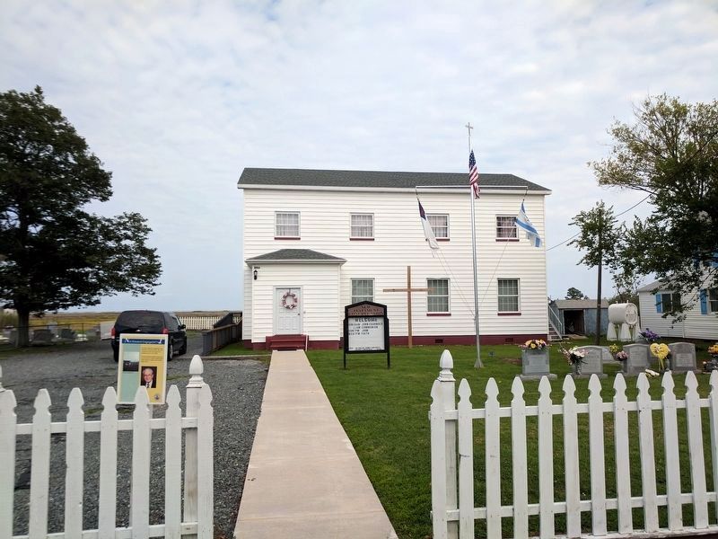
The New Testament Congregation was dedicated on Easter Sunday, 1957, and occupies the same site used for the Chautauqua tent in the 1920's.
The New Testament Mission House was once the home of teacher Alfred Benson (1893-1963) who taught at . . . — — Map (db m207732) HM
Factory Road was originally named New Road. It is said to have been built by Henry Frazier, a Black man, by hand, around the time of the Civil War. In 1919, George Lawson of Crisfield, MD in association with the Kegan, Grace & W. Shirt Makers Guild . . . — — Map (db m106988) HM
Owner Milton Parks has provided warm hospitality to boaters for decades. His marina serves local watermen, commercial and recreational boat traffic.
(captions)
Milton Parks on his scooter - Kaye, 2005
Oyster Buy Boats at Park's . . . — — Map (db m106963) HM
The new house on the corner of Garman Road and Main Ridge is the site of the former Peter S. Crockett Store, later Daughtery & Ward, and then Haynie Grocery.
It had a two-story front porch and was featured in many old photographs. . . . — — Map (db m106972) HM
Charles "Puge" Charnock (1936-2003) was one of Tangier's most beloved watermen. He not only was in the crab shedding business, but also sold ice and bait to the watermen. From his dock, and the adjoining County Dock, Tangier's famous shell crabs . . . — — Map (db m299429) HM
Spanky's Place, now an ice cream parlor with a 50's theme, is one of many businesses to occupy this site. These include Michael Thomas's store that sold stoves and propane, Jolly Jim's Restaurant, Nice's Place, and the Roadside Restaurant. It was . . . — — Map (db m106966) HM
The most prominent of the island's buildings, Swain Memorial United Methodist Church is easily recognized as the focal point of Tangier.
Built in 1899 on the site of the island's second church (1842), it is the center of the Tangier's . . . — — Map (db m39998) HM
Tangier Beach is a 1.5 mile long pristine sand beach, accessed over a narrow wooden pedestrian only bridge, and the best site for watching the island's glorious sunsets
Off the end of the beach at the southwest tip stands the current . . . — — Map (db m299450) HM
The location of the first school on Main Ridge (1871) is unknown, although at the turn of the 20th century Canaan Ridge also had its own school.
The second school, built in 1905, stood at the site of the present day basketball court. In 1930 . . . — — Map (db m299451) HM
Mailboat Harbor replaced Steamboat Harbor in the 1930’s as the age of steamboats came to a close. The harbor was first dredged in 1922, from the Eastern side. In 1967, the harbor was dredged through to the Western side of the island. This was a . . . — — Map (db m39554) HM
This is the site of the former Lewis Crockett Store. It is also the site where in 1936, the Goodyear Blimp arrived with provisions to feed the islanders, who had been frozen in for over two months during a record freeze.
The Visitors Center . . . — — Map (db m106969) HM
The island was visited in 1608 by Captain John Smith, who gave it the name. A part was patented by Ambrose White in 1670. It was settled in 1686 by John Crockett and his sons’ families. In 1814, it was the headquarters of a British fleet ravaging . . . — — Map (db m46705) HM
In honor of the men and women of Tangier Island who have served their country faithfully since World War II
★ Eskridge, Warren R. •
★ Shores, Nolan L. •
★ Crockett, James C.
Parks, Edward F. •
Armstrong, Jack O. • . . . — — Map (db m107036) WM
In honor of the men and women of Tangier Island who have faithfully served their country.
★ Brandon Neil Parks
A. Clyde Pruitt, Sr. •
Lorie Pruitt •
Milton Parks •
John Holdgrafer •
Charles "Butch" Smarr •
L. Wade Creedle, . . . — — Map (db m107037) WM
In honor of the men and women of Tangier Island who faithfully served their country in World Wars I and II
World War I
★ Crockett, William L. •
★ Crockett, Tubman
Bradshaw, J. Gosten •
Bradshaw, Robert J. • . . . — — Map (db m107033) WM
[First paragraph cannot be interpreted.]
Black Skimmer (Rynchops niger) is black above and white below with a thick black-tipped red-orange bill. It is very long-winged, and is graceful and buoyant in flight, with the head always . . . — — Map (db m299447)
The Tangier Volunteer Fire Department was established in 1964 and moved to this location in 1983.
Fire is especially dangerous on a small island. where wooden houses are close together, allowing fire to spread quickly, especially when fanned . . . — — Map (db m106986) HM
The Telephone Building was built in 1966 by Grover Charnock when radiotelephones were finally replaced with a microwave tower.
In front of this is a new home, built on the site of the former Grand Theater, built in 1929 by Gordon Daley, and . . . — — Map (db m97690) HM
The Amanda Wallace Pruitt House was also the home of Reverend James C. Richardson after his resignation from the Methodist church.
He founded the New Testament Church, which met here from 1948-1956. Services were held in the living room and . . . — — Map (db m106996) HM
The Connorton House was the home of the town Sergeant, Bud Connorton.
On Sunday April 11, 1920, Sergeant Connorton shot and wounded 17 year old Roland Parks. He was trying to enforce a town ordinance that forbade "loafing on store porches and . . . — — Map (db m39954) HM
The Doctor's House was owned consecutively by doctors Samuel Oglesby, William Daisey, Bache Gill, and Charles Gladstone. Dr. Gladstone never lived there, but boarded next door in the Sidney Crockett House.
Dr. Gladstone's former office still . . . — — Map (db m39951) HM
The Double Six Sandwich Shop is where the watermen meet at 3:00 AM for "smokes and coffee" before heading down to the docks to the day's work.
Named for the game of Dominos, the shop is open for sandwiches year-round, and was often considered . . . — — Map (db m39683) HM
The Edward Crockett House was formerly the home of "Sugar Tom" Crockett (1833-1905) the Island's first historian, and author of Facts & Fun, the first written history of Tangier Island. It later served as a hotel and the office of Dr. W.O. . . . — — Map (db m106967) HM
The Emily Pruitt House was home to the island's sail-making seamstress, a critically important job before the invention of motorized boats. — — Map (db m106994) HM
The John Thomas House marks the dividing line between the old Thomas and Wallace family lands.
At the end of the 19th century, these two families owned almost all of the land on the western side of the island. — — Map (db m106991) HM
The Joshua Pruitt House is one of the oldest on Tangier.
Joshua Pruitt (1866-1949) and his wife Amanda took in boarders, teachers, and held worship services in their front yard.
Pruitt traveled to Washington, DC, during the Great . . . — — Map (db m106968) HM
Miss Minnie and Capt. Charlie raised eight children in this house. In order to accommodate the entire family at a single table, Capt. Charlie commissioned Henry Jander to build them a table capable of seating ten people. Later, one son, Orville, . . . — — Map (db m106989) HM
Joshua Thomas (1776–1853) became a skilled waterman from the in his youth and ferried clergymen from the mainland to the islands of the Chesapeake Bay. He converted to Methodism about 1807, was licensed as an exhorter (or lay preacher) and was . . . — — Map (db m97688) HM
Patrick Benson, a ship's captain from Dublin, Ireland, purchased this land in 1879. The middle section of house was completed in 1889. The front section with porch and back section with kitchen and outbuilding were added over the years, but . . . — — Map (db m106977) HM
The Peter Dise House is one of the oldest on the island and was moved from the "Uppards," the now unoccupied marsh north of the harbor.
There were originally four fresh water wells on the island, two on Maine Ridge, one on Canton Ridge and one . . . — — Map (db m39953) HM
The Peter Williams House is one of the island's oldest and largest homes and was once decorated with beautiful "gingerbread."
Williams was the original owner and operator of the grocery store across the street. — — Map (db m299428) HM
The Sydney Wallace House is one of the Island's most admired. Built in 1904 and restored in 1995 by Wallace's grandson, it now operates as the Bay View Inn.
(caption)
Sydney Wallace House - National Geographic, 1973 — — Map (db m106993) HM
Wading birds with long legs, necks and bills feed on aquatic animal life along the shore and marsh at low tide. Some stand still as a statue, others probe the mud with their bill or feet. These birds are common on Tangier.
Great Blue . . . — — Map (db m299448)
For almost 250 years the people of Tangier have wrested a living and a lifestyle from the waters that surround them. Most of their days have been occupied with family, work, church, and the other normal pursuits in which we all engage. But they . . . — — Map (db m97723) HM
For almost 250 years the people of Tangier have wrested a living and a lifestyle from the waters that surround them. Most of their days have been occupied with family, work, church, and the other normal pursuits in which we all engage. But they . . . — — Map (db m106961) HM
For over 250 years, the people of Tangier have wrested a living and a lifestyle from the waters that surround them. Most of their days have been occupied with family, work, church, and the other normal pursuits that we all engage. But they have . . . — — Map (db m299427) HM
For over 250 years, the people of Tangier have wrested a living and a lifestyle from the waters that surround them. Most of their days have been occupied with family, work, church, and the other normal pursuits that we all engage. But they have . . . — — Map (db m299431) HM
Landowner, successful business woman manager, champion of American Independence. Daughter of Naomi and Francis Makemie, founder of organized American Presbyterianism. — — Map (db m7835) HM
Five miles west was the home of the Rev. Francis Makemie, founder of Presbyterianism in the United States. About 1684, Makemie established in Maryland the first Presbyterian Church. Later he moved to Accomac and married. He died here in 1708. — — Map (db m7830) HM
Erected in Gratitude to God And in grateful, remembrance of his servant and minister Francis Makemie, who was born in Ramelton, County Donegal, Ireland, A.D. 1658(?) was educated at Glasgow University, Scotland, and came as an ordained Evangelist to . . . — — Map (db m7838) HM
Welcome to Makemie Monument Park
Designated as A Virginia Historic Landmark September 6, 2006.
And placed on the National Register of Historic Places February 15, 2007. — — Map (db m7833) HM
Commemorates the belief that in this ancient family cemetery were buried near the remains of Francis Makemie, those of his wife Naomi, his daughters Elizabeth and Madame Anne Holden, and his father-in-law, William Anderson. Also those of John . . . — — Map (db m7840) HM
Wallops Island is, home to several suborbital and orbital launch pads. NASA selected this site due to its low population of people and remote location on the East Coast. Thousands of people view scientific, research, and cargo resupply launches . . . — — Map (db m205124) HM
The Aerobee 150 (to the right) was a liquid-fueled sounding rocket that was used at Wallops. This rocket could reach altitudes of 170 miles while carrying 150 pounds of equipment. Design changes and improvements to this rocket led to the development . . . — — Map (db m205123) HM
First launched in 1982, Black Brant IX powered rockets have carried their fair share of experiments, including telescopes, scientific instruments, and technology tests. Black Brant IX's are launched all over the world and perform well in extreme . . . — — Map (db m205109) HM
Dedicated in honor of
Dr. Robert L. Krieger
1916 - 1990
Leader of Wallops from 1948-1981, he guided the facility through years of expansion and research, He was very involved in educational and civic activities on the Eastern . . . — — Map (db m205051) HM
Little Joe rockets paved the way for Project Mercury, NASA's first manned spaceflight program. Seven unmanned Little Joe rockets were launched from Wallops from 1959-1961 to test an escape system for the Mercury capsule. The tests done at Wallops . . . — — Map (db m205115) HM
The Wallops Island Flight Facility was established in 1945 by the National Advisory Committee for Aeronautics and is one of the oldest launch sites in the world. This facility was built to conduct aeronautical research using rocket-propelled . . . — — Map (db m63666) HM
Scientific instruments ranging from 10-100 pounds were carried in the nose cone of this two-stage rocket from 1956-1976. The combination of the Nike booster and the second stage Cajun could reach altitudes of 104 miles. The Nike-Cajun was used to . . . — — Map (db m205062) HM
In the 1970's, the Army had a surplus of Orion motors. NASA saw potential in these unused motors for scientific exploration. Nike-Orion sounding rockets were solid-fueled, two-stage sounding rockets created with a Nike and an Orion motor. These . . . — — Map (db m205117) HM
The visitor center displays NASA’s past, present and future projects, as well as, Wallops flight facility’s role in Aeronautical and Space research. The NASA Goddard Space Flight Center’s Wallops flight facility was established in 1945, and is one . . . — — Map (db m95122) HM
Three miles west stands the third church of Hungars Parish, begun in 1742 and completed by 1751, one of two colonial churches remaining on Virginia's Eastern Shore. The parish built the glebe house or minister's residence, 5.5 miles west, about . . . — — Map (db m48938) HM
A Small Fortress
This room is the casemate of Winslow Battery. Built in 1942, this bunker housed the fort's big guns — two-16-inch 50-caliber barrels.
If you were in this room when the artillery was operational, you would have been . . . — — Map (db m302092) HM
A Changing Way of Life…
Growth Followed the Rails
The Eastern Shore of Virginia, one of the earliest colonized areas in North America, remained a seafood and agricultural region with scattered small towns until the 1880s.
The . . . — — Map (db m206447) HM
• Our first line of defense against coastal storms and the forces of wind and waves.
• Help protect inland areas from flooding and damage.
• Sand storage areas that supply sand to eroded beaches during . . . — — Map (db m302135) HM
Strategically located at the southernmost point of the Eastern Shore of Virginia, Fisherman Island is a vital habitat for the birds and animals that live and nest there and stop off on their journey south. Before it was a wildlife refuge, the . . . — — Map (db m302095) HM
The story of Arlington would not be complete without the inclusion of the enslaved African workers who lived and worked on the property. Probate and census records show that John Custis II had numerous indentured servants and enslaved Africans. . . . — — Map (db m302104) HM
Virginia’s Eastern Shore has been home to Native Peoples, also known as American Indians, for thousands of years. To understand changes in how people lived over the span of time, archaeologists have developed classifications for time periods that . . . — — Map (db m302101) HM
Most of what we know about the Arlington Site has been learned through archaeology. Archaeology is the study of past human activity through the examination of material culture, which means things modified or used by people. This is often the only . . . — — Map (db m302106) HM
Two miles west stood Arlington, original home of the Custis Family, built by John Custis. The family tombs are still preserved there. Governor Wm. Berkeley made his headquarters there during Bacon's Rebellion in 1676. Arlington on the Potomac was . . . — — Map (db m98646) HM
In 1676, John Custis II was recognized as a wealthy and powerful man, not only on the Eastern Shore, but also in Jamestown. When Nathaniel Bacon assembled a militia to overthrow the royal government at Jamestown, Governor William Berkeley fled to . . . — — Map (db m98786) HM
The 90 ton BCR 2000 diesel locomotive came to us in 2018 when the Bay Coast Railroad (BCR) ceased operations in Cape Charles and it was about to go under the cutting torch. Like other railroad stock, the locomotive had been built to last. . . . — — Map (db m302123) HM
The building is the reconstructed railroad passenger station that once served Bloxom, Virginia, a town about 44 miles south of here. Built in the early 1900s, the station conforms to the architecture used in Pennsylvania Railroad passenger . . . — — Map (db m302118) HM
This circa 1950s, fifty-foot, general service box car is an example of a standard design widely used since the 1940s and commonly seen on American railroads through the 1980s. It has a single sliding door on each side; the door at the end of the . . . — — Map (db m302120) HM
The Town of Cape Charles was founded in 1884 by Alexander Cassatt and William L. Scott as the southern terminusof the New York, Philadelphia & Norfolk Railroad. The extension of tracks south from Maryland to Cape Charles opened the Northeastern . . . — — Map (db m48952) HM
Constructed in 1928, this school opened about 1930 for African American children in Cape Charles during
legalized segregation. The building was constructed with contributions from the local African American
community, the State Literary Fund, . . . — — Map (db m51004) HM
This building was constructed in 1901 by R.D.L. Fletcher, Jennings W. Waples, and W.B. Wilson, owners of Cape Charles Ice & Lumber Co., who moved the business to this location from south of the harbor. It is believed to be the first building in . . . — (db m263358) HM
SS Delmarva, SS Princess Anne, and the SS Pocahontas operated out of Cape Charles to Little Creek, VA, from about 1933 to 1950. The first two vessels handled the traffic from 1933 to 1941. In 1941, the SS Pocahontas was built to . . . — — Map (db m52213) HM
Farming is an important part of the Eastern Shore's history. Early crops were mostly grains and some tobacco. When the ferry and railroad arrived, the area became less isolated, vegetables became more profitable.
[Captions:] . . . — — Map (db m302096) HM
who landed at Hunt's Point, Old Plantation Creek, on Easter Sunday 1776 and the same day preached the first Baptist sermon, “At the End of a Horsing Tree.” Opposition of the established church caused him to be deported; but kind Providence brought . . . — — Map (db m224172) HM
Elijah Baker, Baptist preacher, began his ministry in Lunenburg County. As an itinerant in the 1770s, he helped found several churches in the counties along the James and York Rivers. He arrived in this area on Easter Sunday 1776 and traveled to . . . — — Map (db m154163) HM
The fertile fields and plentiful resources that drew Native Americans to Virginia's Eastern Shore similarly enticed European settlers, who came to the region not long after the Jamestown colony was settled in 1607. The archaeological sites at and . . . — — Map (db m302103) HM
Virginia’s southernmost barrier island includes about 1,850 acres of constantly shifting sand. Established as a refuge in 1969, the U.S. Fish & Wildlife Service acquired the last 25 acres of land in 2000.
Protection Fisherman Island . . . — — Map (db m98484) HM
Earliest of railroad signals used wooden balls painted red, white or black. When track was clear, ball was hoisted by station agent. At night a lantern would be attached to the ball. — — Map (db m302117) HM
A Guiding Light
Imagine sailing the Atlantic in the 19th century, before GPS navigation. Sailors looking for the northern entrance to the Chesapeake Bay would look no further than the rhythmically flashing beacon atop the Cape Charles . . . — — Map (db m302097) HM
When the English first visited the Eastern Shore in 1608, they found an area which had been inhabited for centuries by Algonquian Indian Tribes. Today archaeologists have found on or near the Arlington Plantation, shards of ceramics known as . . . — — Map (db m98787) HM
The Cape Charles Historical Society dedicates the historic BCR 2000 locomotive to Jerry Lewis for his longtime service with Eastern Shore railroads. and his work to save this iconic reminder of the once booming railroad operations that created . . . — — Map (db m302125) HM
Each fall, the refuge comes alive with color and sound as millions of birds pass through during their annual southward migration.
On the Move
Driven by instinct, many birds migrate back and forth between their summer breeding . . . — — Map (db m302085) HM
In 1776, county officials took
oath of fidelity to virginia.
Provided men, food & supplies
during ficht for independence
despite threat of privateers. — — Map (db m299678) HM
Exploratory digs here in 1988 and 1994 uncovered a three brick wide foundation of an extraordinary 17th century home. Measuring 54 feet by 43.5 feet, this huge footing supported a structure described in 1709 as a "…Dwelling House built of brick … . . . — — Map (db m98785) HM
From 1879-1880, Peter Jacob Carter was a keeper of the Cherrystone Bar lighthouse that was located just offshore in front of you. It was the third federal job for a remarkable man who was born into enslavement just a few miles north of here in . . . — — Map (db m302133) HM
The structure before you was the elevated pitot house of the car float, or bay barge, Captain Edward Richardson. The barge was built by New York Shipbuilding in Camden, New Jersey for the Pennsylvania Railroad Company (PRR) and launched in . . . — — Map (db m302129) HM
Rails from the original tracks
laid on the riprap jetty in 1884
by the New York,
Philadelphia & Norfolk Railroad,
for officials to spend the night and
dine overlooking the Chesapeake Bay.
Presented in 1995
by the Eastern Shore . . . — — Map (db m61362) HM
The Richmond, Fredericksburg & Potomac (RF&P) Railroad had baggage cars in their passenger trains; this car, #190, was built in the 1930s for that service. The portion of the car with the smaller door was reserved for the Railway Express Agency . . . — — Map (db m302127) HM
This strategic location, at the mouth of the Chesapeake Bay, has proven ideal not only for migratory birds but also for defending our nation's coastline.
World War II at our Doorstep
In 1940, the country readied for war. This site . . . — — Map (db m302086) HM
During the early decades of the l7th century, natives of Angola were brought to the Caribbean islands to work on the tobacco and sugar plantations. From there they were brought to Virginia. In 1619 a Dutch man-o-war ship brought the first Negroes . . . — — Map (db m98793) HM
This double walled, 10,000 gallon, circa 1950s tank car was made for the U.S. Army by the General American Transportation Corporation (now GATX) in Chicago, Illinois. When it operated on the Eastern Shore Railroad (ESHR), predecessor of the Bay . . . — — Map (db m302122) HM
Our caboose is now in its 5th life. Originally built for the Wheeling & Lake Erie Railroad in 1948-49 (1st life), in its Ironville, Ohio, shop, it is 34 feet + 3 inches long and weighs 22.7 tons. A bright red caboose, long a trademark of . . . — — Map (db m302128) HM
A meteor/comet two miles wide crossed paths with Earth 35 million years ago. Moving at the speed of 21 miles per second, it crashed here, and what is today the town of Cape Charles, creating the sixth largest impact crater on earth.
The meteor . . . — — Map (db m85789) HM
In 1882, A.J. Cassatt laid out a new railroad between Pokomoke, MD, and Cape Charles. Construction began April, 1884, the last spike was driven on October 25, 1884.
A.J. Cassatt enhanced the dredging of Cape Charles harbor and designed huge . . . — — Map (db m203786) HM
This small white building is known as the "Jetty House" because of its original location on the north jetty of the Cape Charles Harbor. The harbor was created in 1883 by the New York Philadelphia & Norfolk Railroad to provide a terminal for . . . — — Map (db m302116) HM
(Side 1)
Veterans War Memorial
Dedicated by
American Legion
Northampton
Post 56
Cape Charles, VA.
1989
World War II
W. Richard Karla • Joe Restein II • Thomas Savage • Charles K. Bennett • George E. Ward, Jr. • . . . — — Map (db m206348) WM
This preserve is the culmination of years of effort by several groups to ensure its permanent protection. It is now owned by The Archaeological Conservancy, and contains the remains of archaeological sites ranging from prehistoric settlement . . . — — Map (db m302099) HM
Fort John Custis was defended by a number of batteries with various artillery, including Battery Winslow with its two 16-inch guns. These large guns were similar to the ones used on the battleships of World War II. A rail system was laid . . . — — Map (db m302089) HM
Has been designated a National Historic Landmark This site possesses National significance in commemorating the history of the United States of America
This rare fragment of 18th century Chesapeake landscape, with its Georgian house and . . . — — Map (db m94382) HM
1.8 miles east of here stood Salem Methodist Church (1836-1918), scene of the initial violence resulting from the schism between northern and southern Methodists in 1846. A northern circuit preacher was dragged from the pulpit by members of the . . . — — Map (db m7585) HM
Tidewater Institute was incorporated in 1903 with the stated purpose of establishing an industrial, academic, collegiate, and seminary boarding school for the education of black youth. Founded by the Rev. George E. Reid, and supported by the . . . — — Map (db m7586) HM