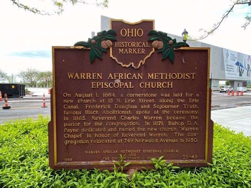
On North Summit Street (Ohio Route 65) at Discovery Way, on the left when traveling north on North Summit Street.
Original Site of Toledo's Oldest Black Institution. In 1847, eight persons formed a mission parish of the African Methodist Episcopal Church (Sandusky Circuit). Reverend Henry J. Young, the minister, had come to Toledo through the Underground . . . — — Map (db m172326) HM
On Jefferson Avenue at North Summit Street, on the right when traveling east on Jefferson Avenue. Reported missing.
[East Side of Marker]:"Port Lawrence"
This pioneer village, which was united with its downriver rival, Vistula, to be incorporated as Toledo in 1837, was platted by Cincinnati businessmen in 1817. The "Panic" of 1819 caused the . . . — — Map (db m191363) HM
Near Jackson Street just east of North Erie Street ( Route 25), in the median.
Project Blue Light is a nationwide recognition of those
Police Officers who have died in the line of duty. It began
in 1988 in Philadelphia when the late Dolly Craig wrote a
letter to Concerns of Police Survivors (COPS), stating that
she would . . . — — Map (db m173214) HM
On Jackson Street west of North Erie Street, on the left when traveling west.
This monument erected by Spanish War veterans, patriotic organizations and citizens of the city of Toledo to commemorate the valour and patriotism of the men who served in the War with Spain, Philippine Insurrection and China Relief Expedition . . . — — Map (db m121997) WM
On Madison Avenue at Water Street, on the right when traveling east on Madison Avenue.
On the night of January 3, 1894, Toledo's largest fire broke out in the massive King-Quale grain elevator. A westward wind from the Maumee River drove flames toward the center of Toledo's business district. The blaze destroyed several buildings . . . — — Map (db m191364) HM
On North Superior Street 0.1 miles north of Jackson Street, on the left when traveling north.
The Toledo Blade is the city's oldest continuing business. The newspaper was first published on December 19, 1835, during the Ohio-Michigan boundary dispute known as the "Toledo War." The name is derived from that conflict and the famous swords of . . . — — Map (db m121496) HM
On North Michigan Street (Ohio Route 25) just south of Jackson Street, on the right when traveling south.
"To acknowledge the duty that
accompanies every right"
The First
Y's Men's Club
Was founded November 22, 1922
in the
YMCA
located on this site
Judge Paul William Alexander, First President — — Map (db m173260) HM
On Adams Street just west of North Erie STreet ( Route 25), on the right when traveling west.
On January 1. 1897, this building was first
opened to the proud citizens of Lucas County
Currently. The Lucas County Courthouse contains
the courtrooms of ten Common Pleas General
Division Judges. as well as offices of the
Prosecutor, Clerk . . . — — Map (db m171201) HM
On Jackson Road at North Huron Street, in the median on Jackson Road.
[Front Side of Marker, Facing South]:"Toledo"
After consolidation of the villages of Fort Lawrence and Vistula, the City of Toledo was incorporated in 1837. Originally named "Toledo" in 1833, the site became part of Ohio when the . . . — — Map (db m27063) HM
On North Michigan Street at Madison Avenue, on the right when traveling north on North Michigan Street.
SIde A
Toledo's First High School
Toledo High School opened in 1854 on the site of the city's first log schoolhouse. After an 1895 fire, it was rebuilt and named Central High School. The facility closed in 1914 with . . . — — Map (db m94891) HM
On Adams Street just west of North Michigan Street ( Route 25), on the left when traveling west.
Here is the cornerstone of Toledo's Memorial Hall, dedicated 1886
to the honor of the soldiers and sailors of Lucas County in the late
war, and m memory of those who' gave up their lives in the
maintenance of our country. The Hall became an . . . — — Map (db m172988) HM WM
Near Adams Street east of North Michigan Street (State Route 25), on the left when traveling east.
In recognition of
the Patriotism of
the People of
Lucas County
who so generously purchased
War Savings Stamps in 1918
this tablet is
gratefully erected by the
Ohio War Savings Committee — — Map (db m121995) WM
On Adams Street east of North Michigan Street (State Route 25), on the left when traveling east.
(panel 1)
William McKinley
Born at Niles – Trumbull County, Ohio
January Twenty-Ninth – Eighteen Hundred and Forty-Three
Volunteer Soldier of the Rebellion
Representative in Congress
Twice Governor of Ohio
Twice . . . — — Map (db m121996) HM
On Adams Street at 14th Street, on the right when traveling east on Adams Street.
Since 2004, the building at 14th and Adams Streets has been the home of the Toledo School for the Arts. The Willys-Overland Corporation erected the building c. 1916 to finish, ship, and sell the company's cars. The popular Whippet and other models . . . — — Map (db m191366) HM
On Jackman Road at Central Avenue, on the right when traveling north on Jackman Road.
This memorial honors
all the men and women
who have served in the
armed forces of the
United States of America
Memorial Day 1999 — — Map (db m301917) WM
On South Marina Drive at Riverside Drive, on the left when traveling north on South Marina Drive.
Rich in resources and strategically located, the Great Lakes were a prize sought by three nations in wars from the French and Indian War to the War of 1812, when the Lakes were settled as the boundary between the United States and Canada. Peace, . . . — — Map (db m204823) HM
On South Marina Drive, on the left when traveling north.
The bounty of the Great Lakes has drawn people to these shores for at least 10,000 years. The area's first inhabitants were North American Indians and their ancestors, who hunted for food and fur, farmed the land, and fished the waters. Europeans . . . — — Map (db m204627) HM
On Miami Street (Ohio Route 65) at Hathaway Street, on the right when traveling south on Miami Street.
A Prehistoric Fort consisting of earthen walls accompanied by moats, formerly occupied this site. The walls, three to four feet high, probably were surmounted by palisades which together with the steep river banks, rendered the fort fairly secure . . . — — Map (db m196956) HM
On Riverside Drive west of South Marine Drive, on the right when traveling west.
By the early 19th century, Great Lakes abundant natural resources drew a massive influx of European immigrants and settlers from the original 13 colonies to the region. With this great migration came development: farming, timber, mining, railroads, . . . — — Map (db m204824) HM
On South Marina Drive, on the left when traveling north.
During World War II, twenty-eight diesel electric submarines were constructed for the United States Navy by the Manitowoc Shipbuilding Company in Wisconsin. Twenty-five of the boats were completed in time to see combat action in WWII. Four of the . . . — — Map (db m204805) HM
On Front Street, on the left when traveling north.
The first anchors were large rocks tied to ropes and dropped to the sea bottom; later came iron hooks Eventually anchors took on the familiar shape known today; two flukes at the end of a shank that stopped by a stock set perpendicular to the flukes . . . — — Map (db m204612) HM
On Front Street, on the left when traveling north.
Dropping and raising the anchor on a large ship is a big job-
too big for manpower alone. Sometime in the 14th century,
Spanish shipbuilders came up with a solution: the capstan.
The first capstans were timbers mounted vertically in the . . . — — Map (db m204853) HM
On Front Street, on the left when traveling north.
You are now at the stern or after most part of the ship, which is
constructed with a classic "fantail” design.
To your right you will see one of the ship's six Mooring
Winches. The green object (steel bar) on the deck in front
of you is . . . — — Map (db m204869) HM
On Front Street, on the right when traveling north.
Look down and you will see a short
white line painted on the deck. We
are now going to compare the size of
the S.S. Col. James M. Schoonmaker
to the Veterans' Skyway Bridge. If we
could stand this ship on its stern with
the bow (forward end) . . . — — Map (db m204870) HM
On Front Street, on the right when traveling north.
Just forward of Hatch #1 are Deck Winches 1&2, which were
used for mooring the forward end of the vessel. In order to tie
up the vessel, deckhands were placed on the dock via the
green landing boom and yellow landing chair. You will also
notice . . . — — Map (db m204872) HM
On South Marina Drive, on the right when traveling north.
While Schoonmaker was originally launched with 35 telescoping hatches, she was re-configured in 1942 to employ this
6 1/2 TON NORTHERN ENGINEERING WORKS Hatch
Crane and now has 18 hatches.
This crane rides up and down the ship's deck along . . . — — Map (db m204867) HM
On South Marina Drive, on the left when traveling north.
A boat's direction is controlled by the rudder, a kind of stiff flap mounted behind the ship's stern (end). Turning the rudder, and thus the ship, requires turning the ship's wheel. The wheel and rudder are connected by a vertical shaft called the . . . — — Map (db m204827) HM
On Riverside Drive west of South Marina Drive, on the right when traveling west.
Safeguarding Our Water
The Great Lakes Water Quality Agreement (GLWQA) is an agreement between the United States and Canada to protect and restore the waters of the Great Lakes. Developed by the International Joint Commission and first . . . — — Map (db m204825) HM
On South Marina Drive at Riverside Drive, on the left when traveling north on South Marina Drive.
Unique on the planet, the Great Lakes have a rich history that began over 10,000 years ago when retreating glaciers carved and then filled basins to form these inland seas. Since then, they have been a powerful force both geologically and . . . — — Map (db m204886) HM
On Front Street at Morrison Drive, on the left when traveling east on Front Street.
Historic Habitats
In the early 1800s, wetlands located in and around this area were prime habitats for many kinds of ducks and geese. Native, aquatic vegetation that grew nearby was an important food source for waterfowl – especially during . . . — — Map (db m173547) HM
On Morrison Drive 0.3 miles north of 6th Street, on the right when traveling north.
Welcome to the Morrison P. Waite High School Memorial Plaza and Garden. This portion of the campus is dedicated to remember those students of Morrison R. Waite High School who made the "ultimate sacrifice" to insure the freedoms we enjoy and to . . . — — Map (db m256354) WM
On Morrison Drive 0.3 miles north of 6th Street, on the right when traveling north.
In grateful memory
to the men of
Morrison R. Waite
High School
who died in World War II
Richard A. Ahlman • Frank E. Aldrich • John Ane • William C. Austin • Rexford G. Bauman • George G. Bee • Donald M. Bennett • Richard D. Bentz Jr. • . . . — — Map (db m256355) WM
On White Street at Ellis Avenue, on the left when traveling south on White Street.
Peter Navarre, 1790-1874. Considered the first citizen of the East Side, Peter Navarre, along with his brother Robert, first settled the land east of the Maumee River in 1807. A fur trader by profession, Navarre was experienced in wilderness . . . — — Map (db m19555) HM
On Front Street, on the left when traveling north.
For centuries, the only way to move a boat across
the water was by oar or by sails, each of which had
its drawbacks. Rowing is difficult; sails need wind.
Paddlewheels were an improvement in propulsion,
but still were inefficient the bigger the . . . — — Map (db m204859) HM
On South Marina Drive, on the left when traveling north.
For millennia, ships out of sight of land navigated by using the position of the sun, moon, and stars. The discovery of radio waves changed navigation forever. By the late 1920s, ships used special antennas called radio direction finders (RDF) to . . . — — Map (db m204613) HM
On Front Street, on the left when traveling north.
When she was launched in 1911, the SS Col. James M.
Schoonmaker became the new Queen of the Lakes-the
longest ship on the Lakes-at 617 feet. What distinguished
her was her width of 64 feet, designed to fill the Soo Locks.
She sailed the Lakes . . . — — Map (db m204858) HM
On South Marina Drive, on the left when traveling north.
Experienced ship-spotters can tell the difference between
seemingly identical ships with just a glance. How? Every
shipping line uses unique hull colors, fleet flags, and
markings on their smokestacks to identify their boats. In
1900, 3000 boats . . . — — Map (db m204850) HM
On South Marina Drive, on the left when traveling north.
The USS Toledo, SSN 769, is a nuclear powered attack submarine and the third vessel to be named for the City of Toledo. The Toledo was built by the Newport News Shipbuilding and Dry Dock Company and commissioned on 24 February 1995. The Toledo's . . . — — Map (db m204624) HM WM
On South Marina Drive, on the left when traveling east.
The National Museum of the Great Lakes
Founded in 1945, the Great Lakes Historical Society has made known and preserved the history of the region for decades. In 2003, the Society embarked on a strategic plan to create the National Museum . . . — — Map (db m204611) HM
On West Central Avenue at Auburn Avenue, on the right when traveling west on West Central Avenue.
Founded in 1876 by a group of Toledo businessmen, Woodlawn Cemetery was designed in the tradition of the country's "rural cemetery" movement, which was first popularized in Europe in the 1830s. This movement reflects the change in American burial . . . — — Map (db m27214) HM
On Central Avenue at Jackman Road, on the right when traveling west on Central Avenue.
John Gunckel dedicated his life to uplifting Toledo’s underprivileged youth. Through the Newsboys Association, he gave thousands of young boys structure, purpose, and a sense of belonging.
This 26-foot pyramid, built in 1917 from over 30,000 . . . — — Map (db m301913) HM
Near Hillcrest Avenue 0.2 miles east of Jackman Road, on the right when traveling east.
Places to Preserve
Woodlawn Cemetery is a classic example of a rural or "garden"
cemetery, that emphasizes nature and art with lush landscapes.
The winding paths, lakes, gently undulating land, a rich blend
of flora, and funerary . . . — — Map (db m170994) HM
On Jeep Parkway at Willeys Parkway, on the right when traveling south on Jeep Parkway.
The Toledo-Lucas County Port Authority played an integral role in retaining the architecturally significant "OVERLAND" smoke stack that has been a highly visible feature of the Jeep Parkway property since 1915.
The 100-foot stack is a prominent . . . — — Map (db m307441) HM
On MUOT Boulevard north of Glendale Avenue, on the right when traveling north.
State interest in medical education for northwest Ohio became a reality when the Medical College of Ohio at Toledo was established in December, 1964. Located initially at South Detroit and Arlington on Lucas County property, MCO moved to the present . . . — — Map (db m94749) HM
On Garden Lake Parkway at Billy Johnson Way, on the right when traveling south on Garden Lake Parkway.
Joseph F. Clunk, a blind Ohioan and an advocate for workforce development, inspired Toledo leaders in 1923 to serve their blind community. With cooperation from the Lions Club, Community Chest, Toledo Rotary Club, and Chamber of Commerce, the . . . — — Map (db m300525) HM
On East Campus Drive 0.3 miles south of Arlington Avenue, on the right when traveling north.
[Front Side of Marker] : "The Toledo State Hospital New Cemetery, 1922-1973"
Toledo State Hospital opened in January 1888 as the Toledo Asylum for the Insane. People were admitted with mild to severe forms of mental illness, and a . . . — — Map (db m30782) HM
On Arlington Avenue 0.3 miles west of South Detroit Avenue (U.S. 24), on the right when traveling west.
[Front Side of Marker] : "The Toledo State Hospital Old Cemetery, 1888-1922"
Toledo State Hospital opened in January 1888 as the Toledo Asylum for the Insane. Originally located immediately south of this cemetery, the hospital was . . . — — Map (db m30791) HM
On East Manhattan Boulevard, on the left when traveling east.
In memory of our
deceased veterans
American Legion
Argonne Post 545 •
Roman "Buddy Frankowski
Post 5530 V.F.W. •
General Anders Polish
Army Vets Post 74 •
Jude Thaddeus Post 1675
Catholic War Veterans — — Map (db m217113) WM
[Text on Front Side of Marker]
F. C. L.
[Text on Right Side of Marker]
George Duncan Forsyth
Lt. Co. B. 100th O. V. I.
Captured at Limestone Station
Sept. 8, 1863.
Shot and Killed
in Libby Prison.
Apr. 12, 1864, . . . — — Map (db m44765) HM
On Baker Street east of Mulberry Street, on the right when traveling east.
Pitched professional baseball's first perfect game, June 12, 1880 for Worcester, Mass. against Cleveland in a National League contest. As baseball's first regular left handed pitcher, he forced opposing teams to change their batting strategies. His . . . — — Map (db m309173) HM
On Blanchard Street, on the right when traveling north.
From Big Top to Big Screen
Joseph Evans Brown was born on July 28, 1892 in Holgate,
Ohio and moved to Toledo as a young child. He worked as a
Toledo newsboy at the age of 7 before joining the circus at age
10. He later toured with the . . . — — Map (db m217115) HM
On Windemere Boulevard at Manhattan Boulevard, on the right when traveling east on Windemere Boulevard.
Famous Scout Whose loyalty, courage, and resourcefulness aided the United States in retaining this territory during the War of 1812 – 1815. His grave is 400 feet south of this spot. This memorial erected October 6, 1923. by The Peter Navarre . . . — — Map (db m19552) HM
Private Mark Wood, Company C, 21st Ohio Volunteer Infantry Died July 11, 1866 Congressional Medal of Honor winner
Pvt. Wood, a union soldier during the Civil War, was a member of the famed Andrews Raiders, who took possession of the Confederate . . . — — Map (db m19087) HM
On Collingwood Boulevard at Virgina Street, on the right when traveling south on Collingwood Boulevard.
Erected a.d. 1844.
Enlarged, 1856.
Destroyed by fire, 1861.
Rebuilt, 1862.
Taken down and rebuilt, 1877.
Erected on present site 1914. — — Map (db m300462) HM
On Collingwood Boulevard north of Virginia Street, on the left when traveling north.
First Congregational Church. Founded in 1833, this is the oldest congregation organized within Toledo's original boundaries. From 1844 to 1913 the church occupied a succession of three meeting houses on St. Clair Street. In 1913 First Church . . . — — Map (db m191370) HM
On City Park Avenue south of Woodland Avenue, on the left when traveling north.
Art Tatum was born in Toledo on October 13, 1909, the son of Arthur Tatum, Sr. and Mildred Hoskins Tatum. Despite being blind in one eye and only partially sighted in the other, he became one of the greatest jazz pianists of his era. To deal with . . . — — Map (db m191371) HM
On Nebraska Avenue near Junction Avenue, on the left when traveling east.
Construction for the current St. Anthony Church began in 1890 after the original wood-frame church became too small to serve the steadily growing congregation of Polish immigrants coming into the Toledo area. Completed in 1894, St. Anthony was . . . — — Map (db m191358) HM
On City Park at Indiana Avenue, on the right when traveling north on City Park.
Stewart's Pharmacy (1922-1945). Stewart's Pharmacy was located at 566 Indiana Avenue on the corner of Indiana and City Park in Toledo. The first Black-owned pharmacy in the city, it was a model of Black entrepreneurship as Ella and William . . . — — Map (db m289022) HM
On Centennial Drive north of West Centennial Drive, on the left when traveling east.
Dedicated to the Aviators of Bravo Troop, 6th Squadron, 6th Cavalry Regiment, who made the ultimate sacrifice in support of the Global War on Terrorism 2001-2011
CW3 Mitchell Carver •
CW2 Kyle Jackson •
CW3 Philip Windorski •
CW2 . . . — — Map (db m217832) WM
On Centennial Drive north of West Centennial Drive, on the left when traveling east.
Dedicated to the following individuals who served their country with honor and valor
Brewster J. Wells, US Army Air Corps Pitot, WWII •
Leonard F. Romanowski, US Navy Seabees, WWII •
Richard Bornhurst, US Navy Seabees, WWII •
C. . . . — — Map (db m217395) WM
On West Centennial Drive, on the left when traveling east.
In memory of the 158 men
who made the supreme
sacrifice in the defense
of their country on May 28,
1945 when their ship, the
Destroyer USS Drexler,
DD-741 was sunk by two
Japanese Kamikaze planes
while defending Okinawa — — Map (db m217709) WM
On Centennial Drive north of West Centennial Drive, on the left when traveling east.
The extended family of Lyman S. (Bud) Eckhart (1921-1983), USMC WWII, and Johanna Mermer Eckhart (1919-1997), WAVES WWII, honors their commitment, service and heroism. — — Map (db m217715) WM
On West Centennial Drive, on the right when traveling east.
The Field House was the second building built on the
Bancroft Campus and was originally funded by a $2.8
million Toledo tax levy that was used to purchase the land
and also build University Hall. The Field House was completed
in 1931 and served . . . — — Map (db m217176) HM
On Calvery Cemetery west of Parkside Boulevard, on the right when traveling west.
Of World War II who lost their lives when the USAT Dorchester was torpedoed by a German submarine U-456 off Greenland February 3, 1943 with 904 men aboard, 605 were lost.
Lt. Alexander D. Goode, Jewish ✡️ •
Lt. George L. Fox, . . . — — Map (db m218033) WM
On Centennial Drive north of West Centennial Drive, on the left when traveling east.
In loving memory of William Erwin Schmertz, LTC US Army and Margaret Gage Schmertz, 1Lt US Army Nurse Corps who proudly and bravely served our country in World War II where their 60-year journey together began — — Map (db m217646) WM
On Centennial Drive north of West Centennial Drive, on the left when traveling east.
In memory of our fathers, Edward D. Ebert (WWII & Korea) and Edward A. Drzewiecki (WWII) and our uncles, Charles Kittle (MIA in WWII) and Raymond D. Drzewiecki (WWII) from Toledo, who proudly served their country. — — Map (db m217358) WM
On Centennial Drive north of West Centennial Drive, on the left when traveling east.
In memory of Sgt. Louis R. Balog, 5th Special Forces Group, who was KIA on 4 Feb. 1968, Vietnam. He served his country so that his family and his community may live in freedom. — — Map (db m217404) WM
On West Centennial Drive, on the left when traveling east.
Your family and country
thank you for your service
John A. Brown Sr.
Honorable Mention
AP Football All American, 1967
University of Toledo Alumnus, 1969
Decorated 1st Lieutenant
101st Airborne Division
Vietnam, 1970-1971
With Love . . . — — Map (db m217710) WM
On West Centennial Drive, on the left when traveling east.
"The Forgotten War"
This plaque honors the
sacrifices of those men and
women who served during the
Korean War.
"Freedom Is Not Free" — — Map (db m217398) WM
On Centennial Drive north of West Centennial Drive, on the left when traveling east.
In memory of
Lester Samuel Fought, Jr.
Major 23rd Marines 4th Division
Iwo Jima, Volcano Islands, Japan
May 23, 1919 - February 22, 1945
University of Toledo Graduate 1941
Loving husband, father,
son and brother
May we . . . — — Map (db m217391) WM
On Centennial Drive north of West Centennial Drive, on the left when traveling east.
Donated by the Lockard Family:
SFC, Frederick W. Lockard III, PhD., Persian Gulf War, Boznia-Herzegovina •
LTC, Brandee Sherette Lockard, Boznia-Herzegovina, Operation Iraqi Freedom •
Specialist Matthew Scott Lockard •
Specialist . . . — — Map (db m217393) WM
On Centennial Drive north of West Centennial Drive, on the left when traveling east.
In Memory Of
Major Hulon Brocke Whittington
U.S. Army Retired
41st Armored Infantry
2nd Armored Division
WWII Congressional
Medal of Honor Recipient
Serving His Country From
1940-1963
"Preparedness is the . . . — — Map (db m217360) WM
On Centennial Drive north of West Centennial Drive, on the left when traveling east.
May future generations remember the dedication of those who served and sacrificed so that we might remain free.
AT2 Charles R. Block, Jr., USN, 1973-77 •
E4 Charles A. Block, II, USA, 2003-10 •
BM3 Benjamin P. Block, USCG, 2003-07 • . . . — — Map (db m217351) WM
On Centennial Drive, on the left when traveling east.
Alfred E. Ehret
Staff Sgt. Army Air Corp. •
Arnold R. Kill
Sgt. Army Air Corp. •
Donald J. McQuade
Torpedoman 1st Class
United States Coast Guard •
Richard B. McQuade, Sr.
Lt., United States Navy •
Louis E. Sendelbach
Cpt., United . . . — — Map (db m217720) WM
On Centennial Drive north of West Centennial Drive, on the left when traveling east.
In memory of the gallant airmen who bombed the oil fields of Ploesti, Romania…
especially the forgotten 500 that the Halyard Mission rescued between 8/2/1944 and 12/27/1944
We remember!! — — Map (db m217649) WM