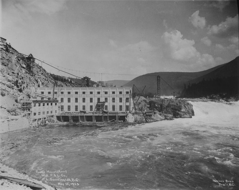
When hydro-electric power was first delivered from No. 1 plant to Rossland's mines in 1898, the 32-mile transmission lines were the longest on the continent. Utilizing the 360-foot drop from Kootenay Lake to the Columbia River, additional . . . — — Map (db m187946) HM
[English] This historic Bridge commemorates an achievement of the Doukhobors of Canada in establishing communal settlements in the Kootenay Boundary region of British Columbia during the early 20th century. Built in 1913 by community labour, . . . — — Map (db m197114) HM
Sawmill pilings and a burner are the only reminders of the former Patrick Lumber Co., established in 1907. By 1911, the Patricks sold the mill to the British Canadian Lumber Corporation. Joseph and sons Frank and Lester risked the proceeds to . . . — — Map (db m187882) HM
It was the dream, in the 1880's of W.A. Baillie-Grohman, British sportsman and financier, to reclaim these fertile flats from the annual river floods. His canal at Canal Flats diverted part of the Kootenay into the Columbia but was abandoned. The . . . — — Map (db m188032) HM
Modified greatly, this former Lodge's ice cream parlour was a structure that began as a
replacement for a former waterfront business operated on Bay street by
Amy & Ted Lodge. Evolved into a grocery store in the 1950's and a sporting goods
store . . . — — Map (db m303282) HM
The construction of the new Masonic Block, the largest building in Nakusp at the time housed the Post Office (which had been on Bay Street) and the Bank of Commerce moved into the main floor of the new building. It holds a meeting room upstairs for . . . — — Map (db m303283) HM
The courthouse formerly held a jail, forestry office and Provincial
Government office. It is recognized as the last building of its kind built in BC
and the only one still in use today. — — Map (db m303278) HM
This Catholic Church was built entirely with donations from local people
and is the only original place of worship still used for that purpose in Nakusp.
In 1950, the rectory was added and in 1954 a new church entrance was built. — — Map (db m303280) HM
As this community prospered in the 1890s, tent hotels and log stores gave way to ornate edifices, and Nelson changed from a crude mining camp into the "Queen City of the Kootenays." The gully that divided Baker Street in two was bridged in 1890, . . . — — Map (db m187922) HM
The 1902 opening of Nelson's new Dominion of Canada offices for postal, customs and inland revenue at 502 Vernon street was a huge step up from the tent that first housed Nelson's postal service. The building, constructed of Spokane brick and local . . . — — Map (db m197112) HM
The orebody, known to Indians as
a source of lead for musket balls,
was staked in 1882 by Bob Sproule,
later restaked by Tom Hamill. The
resulting lawsuit cost Sproule
the property, and in revenge he
murdered his rival; was convicted
and . . . — — Map (db m187919) HM
In the the early 1860s placer gold drew prospectors from all parts of the West to the Salmo River valley, and the Dewdney Trail from the west coast soon opened the region to increased travel. Development increased dramatically in 1893, when Daniel . . . — — Map (db m187931) HM
Silver was the key that opened the Slocan. Discovery in 1891 of the rich outcrops of the "Slocan Star" and "Payne" touched off the wildest lode excitement in our history. The silver-lead ore was easily and cheaply mined, speeding development, and . . . — — Map (db m187952) HM
In 1808 David Thompson named this flat “McGillivary's Portage” as he crossed from Columbia Lake to the Kootenay River. In 1889 W.A. Baillie-Grohman joined the two waterways by a canal with a single lock. Regulations aimed at preventing Columbia . . . — — Map (db m188022) HM
The Canadian Pacific Railway helped open up south-east British Columbia with a strategic line through the Rocky Mountain Crowsnest Pass. It also helped maintain Canadian sovereignty over Kootenay mineral wealth which had been flowing south to . . . — — Map (db m187918) HM
Canada's National Poultry Breed
Created by a monk named M. Wilfred Chatelaine (1876-1963) in the Province of Quebec in 1919. The Chantecler chicken was bred to be a 'dual-purpose' breed, meaning they provided good meat and good egg . . . — — Map (db m303271) HM
The 1864 gold rush at Wild Horse Creek created
the town of Fisherville, named after Jack Fisher,
prospector. Located approximately 6 kms. up
Ft. Steele Wildhorse Road, it briefly flourished
as a home for hundreds of gold-hungry miners.
When . . . — — Map (db m288764) HM
Gold miners poured into this area in the 1860’s crossing the Kootenay River at the foot of this street. The settlement that grew up here was first called Galbraith’s Ferry.
In 1887 the N.W.M.P. established a post here when friction developed . . . — — Map (db m100115) HM
In 1864, whispers of "Kootenay Gold" circulated along the Pacific Slope, drawing prospectors from across the West to an area known as... — — Map (db m288765) HM
A colourful steamboat era preceded the railways. During mining boom days of 1893-98 a fleet of sternwheelers ran north from the railway at Jennings, Mont., to Ft. Steele and vicinity.
Carrying prospectors, freight, and ore they battled . . . — — Map (db m187987) HM
Kootenay gold discoveries attracted thousands of prospectors from Washington Territory in the late 1850s and 1860s. In those years all trails led south into Washington and Idaho and the vast bulk of the treasure and commerce enriched those regions. . . . — — Map (db m187913) HM
In 1893 a Kootenay Indian, Pierre, found a rich galena outcrop in the hills nearby. Father Coccola of St. Eugene Mission arranged sale of the claims, and with the proceeds built a new home for Pierre and a new mission church. Development of the . . . — — Map (db m187928) HM
In 1841, Sinclair guided 200 Red River settlers from Fort Garry through the Rockies to Oregon in an attempt to hold the territory for Great Britain. By 1854 he had recrossed the mountains several times by routes which later were followed by trails . . . — — Map (db m187991) HM
Rivers born in Canada's Rockies carved passes eastward to Hudson Bay or westward to the Pacific. This one was long used by Indians, but not shown on maps until the Palliser Expedition of 1860, and then only from hearsay. Michael Phillipps blazed a . . . — — Map (db m288767) HM
Dr. Dawson was one of the most renowned of the early mapmakers of the Pacific Slope. In 1883 Dr. Dawson explored the Crow's Nest Pass for the Geological Survey of Canada. His report demonstrated his extraordinary ability to provide not only . . . — — Map (db m187904) HM
Gone but still remembered — no formal boundaries
divided the communities of Natal, Michel and Middletown —
“home” to thousands of coal miners for generations. Workers
came from many parts of Europe and North America to toil
in these mines. . . . — — Map (db m187935) HM
[English] Born in the Scottish Highlands, Simpson joined the Hudson's Bay Company in 1820. In 1821 he became governor of the Northern Department, and in 1826 governor-in-chief in Rupert's Land. An energetic administrator with a . . . — — Map (db m201674) HM
Timber in abundance, woodsmen ready to work, a river to float logs, and a railway to transport products: ingredients critical to the emergence of early twentieth century mills in the Kootenay River basin. The Crows Nest Pass Lumber Company at . . . — — Map (db m187939) HM
A reserve on the St. Mary's River was laid out for the Kootenay
Indians in 1884, but as the district's ranching potential became
known, investors pre-empted meadows traditionally used by the
Indians. The Indians made counter claims and . . . — — Map (db m303270) HM
Although prospectors like "Jolly Jack” Thorton worked this area during the 1860s, Boundary Falls was not settled until the 1890s, when a new breed of miners flooded the district. Surrounded by mining properties, the Boundary Falls Smelter (also . . . — — Map (db m187917) HM
Cascade came into being during the late-1890s as a bustling railway construction town claiming 17 hotels at its height. Its location along the Canada-U.S. border proved strategic for mining, freighting, and hydro-electricity. The early development . . . — — Map (db m187915) HM
In 1900, the CPR's Columbia & Western Railway penetrated the formidable mountains between Nelson and Midway, connecting the Boundary district to East Kootenay coalfields and beyond. Eholt, at the summit between Grand Forks and Greenwood, became the . . . — — Map (db m187908) HM
Doukhobors arrived in the Kootenay Boundary area in 1908. Persecuted in Russia for rejecting church rituals and military service, they were derisively named Doukhobors, or ‘Spirit Wrestlers’. Finding refuge in Canada, these Christian pacifists . . . — — Map (db m187884) HM
During the prosperous years of the late 1890s, this street was one of the busiest thoroughfares in the province. Little wonder, for in those years copper was king, and Greenwood — incorporated as a city in 1897 — was the capital of the copper-rich . . . — — Map (db m187914) HM
In this wilderness of rugged mountains, ore was first found in the late 1880's. Further prospects led to the building of a large smelter by the B.C. Copper Co. From 1901, copper, gold and silver poured from its furnaces. Fed by the great Motherlode . . . — — Map (db m187998) HM
When the Midway to Hope section of the “K.V.” was completed in 1916 and joined with existing short lines, it formed a direct southern railroad from Alberta to the Pacific Coast. An important factor in advancing the economy of southern B.C., it has . . . — — Map (db m187941) HM
Proximity to Boundary Creek mines, and excellent climate, water and soil convinced Midway promoters of a bright future as a "railway and residential town.” The Columbia & Western Railway reached Midway in 1900; five years later, the Vancouver, . . . — — Map (db m187938) HM
You have entered the crater of an ancient volcano rich in minerals. The waste dumps are the remains of famous Rossland mines staked in 1890 by prospectors passing on the near-by Dewdney Trail. From these fabulously rich workings came 6,000,000 tons . . . — — Map (db m187953) HM
"A travel route north of the boundary line" was the cry in the 1860's when gold was found in the Kootenays. Edgar Dewdney built such a route — a trail 360 miles long from Coast to Rockies.
For over two decades it carried miners, settlers, gold . . . — — Map (db m187959) HM