By Cosmos Mariner, June 12, 2022
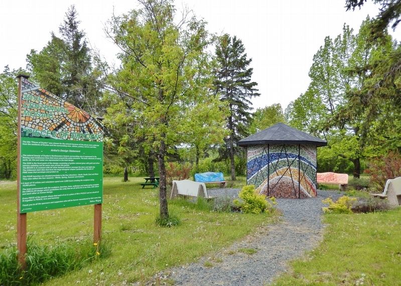
"Pieces of Dryden" Marker
GEOGRAPHIC SORT Title Sort Marker Number Sort Marker Number Sort N Marker Number Sort T Publication Order Sort Publication Order Sort A Erected Year Sort Most Viewed Sort Most Recent-Interest Sort Most Recently Changed Sort SEE FAQ #33 FOR DESCRIPTIONS
Near Provincial Highway 17 at Florence Street, on the right when traveling south.
On King Street just east of Earl Avenue, on the left when traveling east.
On King Street just west of Whyte Avenue, on the left when traveling west.
On West River Road (Duke Street) (Provincial Highway 594) at Earl Avenue, on the right when traveling east on West River Road (Duke Street).
On Earl Avenue at West River Road (Duke Street) (Provincial Highway 594), on the right when traveling south on Earl Avenue.
On Whyte Avenue just south of King Street, on the right when traveling south.
On West River Road (Duke Street) (Provincial Highway 594) at Earl Avenue, on the right when traveling east on West River Road (Duke Street).
On West River Road (Duke Street) (Provincial Highway 594) at Earl Avenue, on the right when traveling east on West River Road (Duke Street).
Near Provincial Highway 17 at Florence Street, on the right when traveling south.
On King Street just east of Earl Avenue, on the right when traveling east.
On West River Road (Duke Street) (Provincial Highway 594) just west of Earl Avenue, on the right when traveling west.
On West River Road (Duke Street) (Provincial Highway 594) at Earl Avenue, on the right when traveling east on West River Road (Duke Street).
On Van Horne Avenue just north of King Street, on the right when traveling north.
On Van Horne Avenue at King Street, on the left when traveling north on Van Horne Avenue.
On King Street just west of Whyte Avenue, on the right when traveling west.
Paid Advertisement
On King Street at Provincial Highway 17, on the right when traveling south on King Street.
On West River Road (Duke Street) (Provincial Highway 594) at Earl Avenue, on the right when traveling east on West River Road (Duke Street).
On West River Road (Duke Street) (Provincial Highway 594) at Earl Avenue, on the right when traveling east on West River Road (Duke Street).
Near Government Street (Provincial Highway 17) at King Street, on the right when traveling east.
On West River Road (Duke Street) (Provincial Highway 594) at Earl Avenue, on the right when traveling east on West River Road (Duke Street).
On West River Road (Duke Street) (Provincial Highway 594) at Earl Avenue, on the right when traveling east on West River Road (Duke Street).
On King Street just east of Earl Avenue, on the left when traveling east.
On King Street just west of Van Horne Avenue, on the left when traveling west.
On King Street at Earl Avenue, on the left when traveling west on King Street.
On Main Street (Trans-Canada Highway) (Provincial Highway 17) at East Street on Main Street (Trans-Canada Highway).
Near Main Street (Trans-Canada Highway) (Provincial Highway 17) just west of West Street, on the left when traveling west.
Near Main Street (Trans-Canada Highway) (Provincial Highway 17) just west of West Street, on the left when traveling west.
Near Main Street (Trans-Canada Highway) (Provincial Highway 17) just west of West Street, on the left when traveling west.
Near Main Street (Trans-Canada Highway) (Provincial Highway 17) just west of West Street, on the left when traveling west.
Near Bernier Drive just south of Main Street South (Trans-Canada Highway) (Provincial Highway 17), on the right when traveling south.
On Lakeview Drive (Trans-Canada Highway) (Provincial Highway 17) just west of Ontario Street (Minnesota Street), on the left when traveling west.
Paid Advertisement
Near Bernier Drive just south of Main Street South (Trans-Canada Highway) (Provincial Highway 17), on the right when traveling south.
On Main Street South (Trans-Canada Highway) (Provincial Highway 17) just north of McClellan Avenue, on the left when traveling north.
On Matheson Street South just north of 2nd Street South (Trans-Canada Highway) (Provincial Highway 17), on the left when traveling north.
Near Bernier Drive just south of Main Street South (Trans-Canada Highway) (Provincial Highway 17), on the right when traveling south.
Near Lakeview Drive (Trans-Canada Highway) (Provincial Highway 17) at Minnesota Street (Ontario Street), on the right when traveling east.
On Bernier Drive just north of 1st Street South, on the left when traveling north.
On First Street South just east of Main Street South (Trans-Canada Highway) (Provincial Highway 17), on the left when traveling east.
On Trans-Canada Highway (Provincial Highway 17) 0.4 kilometers east of Nethercutt Drive, on the right when traveling west.
On Main Street South (Trans-Canada Highway) (Provincial Highway 17) just north of McClellan Avenue, on the left when traveling north.
On First Street North at Matheson Street North, on the right when traveling west on First Street North.
On Matheson Street South just south of First Street South, on the right when traveling south.
Near Bernier Drive close to Main Street South (Trans-Canada Highway) (Provincial Highway 17), on the right when traveling south.
Near Bernier Drive just south of Main Street South (Trans-Canada Highway) (Provincial Highway 17), on the right when traveling south.
Near Lakeview Drive (Trans-Canada Highway) (Provincial Highway 17) 0.6 kilometers west of Bernier Drive (Veterans Drive), on the right when traveling west.
On First Street South at Main Street South (Trans-Canada Highway) (Provincial Highway 17), on the left when traveling west on First Street South.
Near Bernier Drive just north of Water Street, on the left when traveling north.
Paid Advertisement
On Main Street South (Trans-Canada Highway) (Provincial Highway 17) just south of McClellan Avenue, on the right when traveling south.
On Trans-Canada Highway (Provincial Highway 17), on the right when traveling east.
Near Bernier Drive just south of Main Street South (Trans-Canada Highway) (Provincial Highway 17), on the right when traveling south.
Near Bernier Drive just south of Main Street South (Trans-Canada Highway) (Provincial Highway 17), on the right when traveling south.
On Hennepen Lane at 2nd Street South (Trans-Canada Highway) (Provincial Highway 17), on the left when traveling north on Hennepen Lane.
On Trans-Canada Highway (Provincial Highway 17) 10 kilometers east of Willard Lake Road, on the right when traveling east.
On Trans-Canada Highway (Provincial Highway 17) 10 kilometers east of Willard Lake Road, on the right when traveling east.