On 2nd Street (U.S. 52) west of Jack Roush Way, on the right when traveling west. Reported missing.
Israel Donalson, member of the First Constitutional Convention of Ohio.
In May 1800, Congress passed an act building the Northwest
Territory, with the western division becoming Indiana
Territory and the eastern called the Territory of the . . . — — Map (db m136539) HM
Near East 8th Street, 0.2 miles east of Cemetery Street, on the right when traveling east.
Son of Nathan Ellis 1749-1819 Founder of “Ellis Ferry,” now Aberdeen, Ohio Established the Ellis Family Graveyard on his farm near Ellis’ Landing on the Ohio River Sprigg Township, Adams County, Ohio about 1820 ———— It was with thoughtful . . . — — Map (db m185498) HM
Near East 8th Street, 0.2 miles east of Cemetery Street, on the right when traveling east.
A local preacher organized a Methodist Society in 1797 at his home on the Scioto Brush Creek north of the village of Blue Creek in Adams County in the Northwest Territory. In August 1800 the Society built a log church on a site provided by Mr. . . . — — Map (db m185497) HM
On East Front Street at Pike Avenue, on the right when traveling east on East Front Street.
Manchester was founded in 1791 by Nathaniel Massie as a base to
survey the land warrants of American Revolutionary War soldiers in
the Virginia Military District. This bank of the Ohio River provided
a secure site for the last civilian stockade . . . — — Map (db m136536) HM
On West Front Street at Pearl Street, on the right when traveling west on West Front Street.
In 1784, the state of Virginia ceded all of its Northwest Territory
to the federal government except for this tract to satisfy the
land bounties owed to its Revolutionary War soldiers. The Virginia
Military District extended from the Scioto River . . . — — Map (db m136532) HM
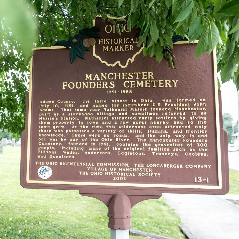
On 2nd Street (U.S. 52) east of Cemetery Street, on the right when traveling east.
Massie’s Station, built in 1791, was the fourth
permanent settlement center in Ohio and the
last stockade settlement built in Ohio.
It
provided protection from the Indians
for
Manchester’s settlers until 1794.
Manchester was . . . — — Map (db m136537) HM
On North Main Street (Ohio Route 41) near Elliott Avenue, on the right when traveling north. Reported missing.
Platted in 1881 by Isaiah Custer on the junction of old Zane's Trace (1796-97) and the Cincinnati & Eastern Railway (1881). Incorporated 1886. Named after John G. Peebles, Portsmouth, Ohio businessman. David Nixon constructed the first house in . . . — — Map (db m223788) HM
On Ohio River Scenic Byway (U.S. 52) 0.3 miles west of Blue Creek Road (County Highway 18), on the right when traveling west.
A thriving riverport in the 19th Century founded in 1835 by William Stout. Elisha Stout, son of William, born and raised here, was one of the founding fathers of Omaha, Nebraska and Denver, Colorado. Former site of Adamsville which served as the . . . — — Map (db m73138) HM
On Main Street (Ohio Route 247) south of Tri County Road, on the right when traveling south.
Founded 1887 by John Q. Roads on the Cincinnati & Eastern Railway (1881) and the Old West Union Road (1807). Incorporated 1911. Named after Franklin Seaman who donated land to the railroad for a station. Home of Will Rogers, "The Black King of the . . . — — Map (db m108200) HM
On West Main Street (Ohio Route 41) at North Cherry Street, on the right when traveling west on West Main Street.
The Bradford Tavern, West Union’s first inn built circa 1804,
served the Maysville-Zanesville stagecoach route and such travelers as Andrew
Jackson, Henry Clay, and Santa Anna. After 1840,
it was continued as the Marlatt House and,
later, the . . . — — Map (db m135307) HM
On Second Street (Ohio Route 247) at East Walnut, on the left when traveling south on Second Street.
side A
First Presbyterian Church
The First Presbyterian Church of West Union, built in 1810, is known as the "Church of the Governors." Although the date is uncertain, the congregation was organized circa 1800 on Thomas Kirker's land on . . . — — Map (db m122227) HM
On West South Street at South West Street, on the left when traveling west on West South Street.
A short distance south of Zane’s Trace, West
Union was established by an act of the Ohio
Legislature on April 13, 1803, as the seat of
Adams County. West Union was surveyed in the
spring of the following year, and became
important stagecoach . . . — — Map (db m135312) HM
On Zane Trace (Ohio Route 41), on the right when traveling south.
Ohio’s first highway and mail route authorized by Congress 1796 marked and cleared in 1797 by Col. Ebenezer Zane a blazed trail, it became the route of the old stage line from Maysville to Wheeling used by noted statesmen to and from the . . . — — Map (db m121836) HM
On Main Street (Ohio Route 136) at Dorsey Road (Local Route 48) on Main Street.
Winchester, Ohio. Founded November 8, 1815 by General Joseph
Darlinton and named for his Virginia birthplace.
Winchester was incorporated in 1864 and later
became the eastern terminus of the Cincinnati and
Eastern Railway (1877-1880). The . . . — — Map (db m133890) HM
On Ohio River Scenic Byway (U.S. 52) 1.5 miles west of State Highway 247, on the right when traveling west.
One half mile north of this monument the home of Gen. Nathaniel Massie, founder of Manchester in 1791, first settlement in the Virginia Military District. Residence of Charles Willing Byrd, Secretary and Acting Governor, Northwest Territory and . . . — — Map (db m45344) HM
On East Elm Street east of North Main Street, on the left when traveling east.
Bluffton, Ohio Est. 1861
Celebrating Our Heritage
This fair lady continues to bless our modern & diverse community.
Early explorers & surveyors paved the way for Mennonite homesteads.
Native peoples enjoying Nature's . . . — — Map (db m196224) HM
On Lincoln Highway (Ohio Route 66) just west of North Main Street (Ohio Route 66), on the left when traveling east.
Delphos
Delphos began and flourished as separate settlements: East Bredeick, West Bredeick, Howard, and Section
Ten (named after a section of the canal). In 1851, Father John Otto Bredeick, a Bavarian priest who had purchased and founded this . . . — — Map (db m159752) HM
On Allentown Road (Ohio Route 81) west of Poling Road, on the right when traveling west.
Settled by veterans
War 1812
Founded by
William Myers
and
George Povenmire
March 15 1834
Early settlers
of
Allentown Ohio
1828 - 1900
John Enslen •
George Myers •
Smith Cremean •
Charles G. Wright . . . — — Map (db m208370) WM
On Lincoln Highway (U.S. 30), on the right when traveling west.
(red Welsh dragon logo)
A village settled by Watkins,
Roberts, and Nicholas families,
bringing with them their Welsh
traditions and establishing a
community in honor of their
native land. — — Map (db m94555) HM
On Defiance Trail North north of Allentown Road (Ohio Route 81), on the left when traveling north.
American prairies began forming 25 to 50 million years ago after the Rocky Mountains were pushed up into existence. This new mountain range reduced the flow of moist Pacific air moving toward the east.
Over the centuries, moisture- dependent . . . — — Map (db m236508) HM
On Lafayette Road, 0.1 miles north of Ada Road (Ohio Route 81), on the right when traveling north.
Following the American Revolution, the British Crown sought to retain possession of the Ohio Country by sending chief British Indian Agent Alexander McKee and others to establish trading posts with Native Americans and resist American settlement. In . . . — — Map (db m238374) HM
On Main Street at North Street (Ohio Route 81), on the right when traveling south on Main Street.
Allen County was originally Indian territory not opened for settlement until 1817, and was formally surveyed in 1820. County government was organized in 1831 and with the improvement of roads, settlers came and established communities in every part . . . — — Map (db m22930) HM
On Bluelick Road, 0.2 miles east of North Main Street (Ohio Route 65), on the right when traveling west.
Here arriving from Logan County in
1824, Christopher Stark Wood estab-
lished on Sugar Creek, the first
settlement in what is now Allen
County. His family and others
joined him soon. Land was cleared;
cabins were built. After only five
years, . . . — — Map (db m80276) HM
On South Main Street at Circular Street, on the right when traveling north on South Main Street.
This street follows the course of an Old Indian Trail that joined the Tawa Indian town on the Auglaize River to the Black Swamp Trail near Lafayette. At one time, this corner was the junction of Three Early Roads, Wapakoneta Rd. - Main St. - . . . — — Map (db m63077) HM
On Eastown Road, on the left when traveling north.
Former location of East Cemetery relocated in 1996 to Greenlawn Cemetery American Township.
In 1832 John East of Pickaway County came to Allen County with his wife, Elizabeth Huffer, and family Mary, Isaac, Abraham, Elizabeth, and Samuel. He built . . . — — Map (db m105378) HM
On Ottawa Road (Ohio Route 65) at North West Street (Ohio Route 115), in the median on Ottawa Road.
In honor of those founders and
patriots of the northwest territory
who settled in Ohio and Allen County
1803 Ohio Sesquicentennial 1953 — — Map (db m77680) HM
On Central Avenue (Ohio Route 309) at High Street, on the right when traveling north on Central Avenue.
Erected in 1852 of handsome bricks, this house, still occupied in 1976, is one of Lima's oldest landmarks. Situated on part of Outlot No. Two of the original city addition, the residence now fronts Central Ave., known as Tanner Ave., before 1897. . . . — — Map (db m29884) HM
On Market Street/Bellefontaine Avenue at the Ottawa River, on the left when traveling east on Market Street/Bellefontaine Avenue.
Built near this site, the cabin of this pioneer Allen County Commissioner was used for the first meetings of the Bath Township Trustees in 1829 and of the Allen County Commissioners June 6, 1831. Daniel's land adjoined the original 160 acre . . . — — Map (db m29874) HM
In 1831, the Shawnee Indians built a 20 x 30 ft. hewed-log council house within their Hog Creek Settlement. It was located about 270 ft. east of this marker. After the Indians’ forced exodus west, it served as a temporary dwelling for the Griffith . . . — — Map (db m100742) HM
On Central Avenue, on the right when traveling north.
Site of Lima's First cemetery and burial place of Pvt. Elijah Stites 1758-1843 Minute Man of the Revolution who served in the Essex County Militia 1st Regiment New Jersey. — — Map (db m93047) HM
On Bluelick Road, 0.1 miles west of Sugar Street, on the right when traveling west.
In 1959 this area was discovered to be an almost four thousand year old burial ground of the Glacial Kame People-named for the distinctive gravel elevations in which their dead were buried. The area was once a farm owned by Henry Boose, an early . . . — — Map (db m78679) HM
On Thayer Road at Mirror Lake Drive, on the left when traveling north on Thayer Road.
Ward Cemetery Burial Site
in the fall of 1825, Samuel McCluer
built a log cabin near this site and
began the arduous task of clearing
away the dense forest for farming.
Not until the following summer did
he learn from hunters, who . . . — — Map (db m80275) HM
On Rockport Road, on the left when traveling west.
Rockport Methodist Church in the community of Rockport (formerly Cranberry) was believed to be one of the oldest churches in northern Allen Co. According to the records of the church, it was formed sometime around 1840, perhaps earlier. It was a . . . — — Map (db m195864) HM
On Fort Amanda Road at Sunderland Road, on the right when traveling west on Fort Amanda Road.
Site of the 86 acre homestead of Dye Sunderland who served in Captain Samuel McCormick's Company of The War of 1812
Here in 1820, on the site of the Indian town of Tawa the Sunderland family established the First Permanent Home in . . . — — Map (db m91455) HM
On Defiance Trail, on the right when traveling north. Reported missing.
Do you see the little cemetery to the east, high on the west bank of the Auglaize? It's all that remains of Hartford, thriving town in the 1830's with, it was expected, a bright future, since the new Miami and Erie Canal would one day be serving . . . — — Map (db m236836) HM
On South Broadway Street (Ohio Route 66) at East 3rd Street, on the right when traveling south on South Broadway Street.
Spencerville was platted in 1844 under the name "Spencer". In 1854, the name was changed to "Acadia", and was incorporated as Spencerville in 1866. The town was located on the banks of the Miami & Erie Canal, and its development as a commercial . . . — — Map (db m196325) HM
On 2nd Street at Cottage Street (Ohio Route 60/511), on the right when traveling west on 2nd Street.
To the heroic pioneers who braved the perils of the pathless wilderness to establish homes for their loved ones, and who laid the foundation of our commonwealth so broad and deep in this their new homeland that their descendants might freely enjoy . . . — — Map (db m25832) HM
On Ohio Route 603, on the right when traveling south.
Tensions between Native Americans and Euro-American settlers remained high on the Ohio frontier during the War of 1812. Grievances mounted rapidly following the removal of the Greentown Delawares to Piqua in the late summer of 1812. On September . . . — — Map (db m28800) HM
On South Market Street (Ohio Route 3) just south of West Main Street (Ohio Route 39), on the right when traveling south.
Construction
Known as the "Workman Cabin,” this log home was built between 1838 and by Morgan Workman.
It originally stood 3 miles
northeast of Loudonville along what was once the old Wooster-Mt.
Vernon Pike & Stage Route which . . . — — Map (db m166359) HM
On South Market Street (Ohio Route 3) south of West Main Street (Ohio Route 39), on the right when traveling south.
A New Home In Central Park
In 1963 the cabin–by then unoccupied since 1915 and its logs hidden by lap siding-was given by Mr, and
Mrs. Gene Lifer, on whose land it stood, to the Mohican Historical Society to use as the . . . — — Map (db m166360) HM
On Lincoln Highway (County Route 30A) at Iowa Street, on the right when traveling west on Lincoln Highway.
Side A
Mifflin was founded in 1816. Originally known as Petersburg, the name was changed in 1827 in honor of the settlers that moved here from Mifflin Township, Allegheny County, Pennsylvania. The first village jailhouse and crossroad . . . — — Map (db m97113) HM
On Ohio Route 39, on the right when traveling west.
A migration of Indians throughout Ohio began due to unstable conditions created by the American Revolution. The massacre of Christian Indians at the Moravian mission of Gnadenhutten in 1782 and Colonel William Crawford’s expedition against . . . — — Map (db m168811) HM
On East Prospect Road (U.S. 20) at State Road, on the right when traveling east on East Prospect Road.
This land was donated to
Ashtabula Township
by
Peleg Sweet
Early settler and
Revolutionary Soldier
It was used as a
training ground for troops — — Map (db m132292) HM
On Walnut Boulevard east of Hulbert Avenue, on the right when traveling east.
Where you are standing on this high bluff, overlooking the entrance to Ashtabula Harbor is referred to as Point Park. For almost two centuries, people have traveled here to observe the business activity of Ashtabula Harbor. This vantage point of the . . . — — Map (db m132374) HM
On East Main Road (U.S. 20), on the right when traveling east.
The Western Reserve
Northeast Boundary Marker
of the Connecticut Western Reserve
conveyed to the United States, September 11, 1786
erected by
the Early Settlers Association
of the Western Reserve, Cleveland, Ohio
July 3, 1966
Early Settlers . . . — — Map (db m94754) HM
On July 4, 1796, Moses Cleaveland and his survey party landed at the mouth of Conneaut Creek on the southern shore of Lake Erie in what is today Conneaut, Ohio. The Connecticut Land Company, a private land speculation enterprise, had hired General . . . — — Map (db m121508) HM
Near South Ridge Road (Ohio Route 84) at County Line Road.
On June 28, 1798
Colonel Alexander Harper
At the head of a party of 25
Landed at the mouth of Cunningham Creek
3 miles North of here
And founded here
The first permanent settlement in Ashtabula Co.
At the time of his arrival
There . . . — — Map (db m163110) HM
On U.S. 322 west of Ohio Route 193, on the right when traveling east.
Original mill stones used in first grist mill in Wayne Township. Weight 3540 pounds. Cut from native stone which proved too soft replaced by French Stone.
Grist mill built by Loomis and Brown on Pymatuning Creek, south of Underwood Rd., in . . . — — Map (db m202393) HM
On Clinton Street at Washington Road, on the right when traveling west on Clinton Street.
Albany
The village of Albany was established in 1838 as a market center for the surrounding agricultural area, which saw its first white settlement in the early years of the nineteenth century. Education was always a major concern of Albany's . . . — — Map (db m52872) HM
On State Street (Ohio Route 550), on the left when traveling east on State Street.
Pioneers began arriving in Ames Township in 1797, making it one of the earliest settlements in the Northwest Territory. As early as 1804, the village purchased enough books to create a library. It is known today as the Coonskin Library because it . . . — — Map (db m15537) HM
On State Street (Ohio Route 550), on the right when traveling east.
In the years leading to Ohio statehood in 1803, Ames Township citizens decided to establish a stock-owned circulating library. Since cash was scarce during Ohio's frontier era, some citizens paid for their $2.50 shares by the sale of animal pelts, . . . — — Map (db m15540) HM
On East Washington Street, 0.1 miles east of North Court Street, on the left when traveling east.
In the spring of 1797, Rufus Putnam sent eleven “substantial men ... possessing firmness of character, courage, and discretion” to found a settlement on the bank of the Hockhocking River. In 1800 the territorial legislature named the . . . — — Map (db m42163) HM
On Court Street at Washington Street, on the left when traveling north on Court Street.
In Memoriam
Honoring the first settlers in Athens Co.
from the New England States
Alvan Bingman •
Silas Bingman •
Isaac Barker •
William Harper •
John Wilkins •
Robert Linzee •
Edmond Dorr •
William Dorr •
Barak Dorr •
John Chandler . . . — — Map (db m15545) HM
On Union Street at Court Street, on the right when traveling east on Union Street.
[Marker front]
Manasseh Cutler, Rufus Putnam, Winthrop Sargeant, and Benjamin Tupper of the Ohio Company conceived Ohio University, which was encouraged by the Ordinance of 1787 and the Northwest Territorial Legislature in 1799, . . . — — Map (db m15564) HM
On West Washington Street at Fort Street, on the left when traveling east on West Washington Street.
This tablet is erected in honor of
Daniel Nelson
founder of Nelsonville
who donated the ground for the
Fort Street Cemetery
the Public Square and this lot
for School and Meeting House purposes
This stone was a part of the doorway . . . — — Map (db m37040) HM
On Main Street at the CSX railroad tracks, on the left when traveling west on Main Street.
The Village of Cridersville was founded in 1856. With the discovery of oil in 1885 the village prospered and grew quickly. Its business district developed along Main Street in the first block east of the railroad. The Town Pond . . . — — Map (db m28668) HM
On East Main Street east of South Water Street, on the right when traveling east.
Cridersville was founded by Ephraim and Polly Crider and their family in 1856. They platted their town along the proposed route of the new Dayton & Michigan Railroad. When the railroad was completed in 1858, the village began to grow. A railroad . . . — — Map (db m237776) HM
On East Main Street east of South Water Street, on the right when traveling east.
Long before there was a State of Ohio, the forests that covered western Ohio were the hunting grounds of native American tribes. The Shawnee tribes established a community on the banks of the Auglaize River that they called Waughpaughkonnetta as . . . — — Map (db m237805) HM
On Ohio Route 66 at County Route 182, on the left when traveling south on State Route 66.
During the canal years of the 1850's a rivalry grew between Bill Jones and Jack Billings for the love of Minnie Warren. This became hatred by Bill because Minnie chose Jack. On a fall night in 1854, returning from a party, Minnie and Jack were . . . — — Map (db m80159) HM
On West 4th Street west of North Frankfurt Street, on the right when traveling east.
Our forefathers brought with them a fervent Catholic faith, low-German language and many traditions. The first Catholic church in Minster was built in 1835. The pioneers erected a log structure forty by sixty feet and sixteen logs high, in the North . . . — — Map (db m238613) HM
On West 4th Street west of North Frankfurt Street, on the right when traveling west.
Represents the strong Christian faith of the community. In the eighth century Charlemagne and Benedictine missionaries brought this faith to the Saxon tribes in the Munster and Osnabruck area of Germany.
Oak Leaf and Acorn - The acorn is . . . — — Map (db m238608) HM
On West 4th Street west of North Frankfurt Street, on the right when traveling west.
Corn May 2, 1793, in Sierhausen, Damme, Oldenburg, Germany. Franz Joseph Stallo was the fifth child of Johann Bernard and Catharina Maria (Liening) Stallo. He was educated in Osnabrück, attending Carolinium Gymnasium, and became a school teacher. . . . — — Map (db m238605) HM
On 4th Street at Main Street, on the right when traveling west on 4th Street.
Francis J. Stallo is the founder of Stallostown, which was later named Minster. This is the site where Stallo owned and built his double wide log cabin. He, Along with John Feldman, John Surham, Frederick Rohenkuhl, and three unknown others made the . . . — — Map (db m102490) HM
On West 4th Street west of North Frankfort Street, on the right when traveling west.
Our ancestors came to America from Germany with the hope and commitment for a better way of life. Leaving their homeland behind, they accepted this new challenge with determination, clearing the virgin forest from their own land. their strong work . . . — — Map (db m238612) HM
On East 4th Street at South Lincoln Street, on the left when traveling west on East 4th Street.
In 1832, 97 Germans met in Cincinnati to purchase a section of land for settlement. Designated leader Francis J. Stallo and six others set out from Cincinnati on foot, heading to the land office in Miami County. They had $800 in silver coins, the . . . — — Map (db m238254) HM
On West 4th Street west of North Frankfurt Street, on the right when traveling west.
Once this land we now call Minster was all a virgin forest with many swamps where Indians and traders traveled on the wilderness trail. After the Treaty of Greenville was signed in 1795 and the Indians left, this land became known as U. S. . . . — — Map (db m238601) HM
On North Lincoln Drive, on the right when traveling north.
This was the site of the first Stallostown Mission Catholic Church in Minster, completed in 1835. The brick wall surrounding the gazebo is representative of the footprint, measuring approximately 40 feet wide and 60 feet long. It was 16 logs high . . . — — Map (db m238253) HM
On Moulton- New Knoxville Road (County Route 91) at Co Rd 33A Plank Pike (County Route 33A), on the left when traveling south on Moulton- New Knoxville Road.
Site of St. Marys – Wapakoneta plank road built 1850- 1852 of Burr
and White Oak timber 3 to 5 ft in diam. cut and milled at Moulton
financed by Wapakoneta – St Marys businessmen who charged toll
for profit and maintenance. Replaced in 1882 by . . . — — Map (db m236424) HM
On South Washington Street (Ohio Route 66) at East Front Street, on the right when traveling north on South Washington Street.
Located at a prime site during the peak canal days, this building was constructed as a residence circa 1848 and later sold in 1864 for an unheard of price at that time -- $3500. — — Map (db m157995) HM
On West Monroe Street (Ohio Route 274) at South Washington Street (Ohio Route 66), on the right when traveling east on West Monroe Street.
Lockkeeper's House
The Lockkeeper's House was the residence of the Lockkeeper and his family. The Lockkeeper was on duty 24 hours a day, seven days per week, and was responsible for operating the lock as needed to move boats through the . . . — — Map (db m22781) HM
On East Plum at Canal Street, on the right when traveling west on East Plum.
This home has been restored from logs and the floor plan of the second oldest cabin in Mercer County. It is an example of a shelter the earliest settlers used in the 1830's. At the first sign of spring, a German immigrant family would move north . . . — — Map (db m100741) HM
Near Lock 2 Road (County Road 70) east of Quelhorst Road, on the right when traveling east.
Robert E. Kuenning Ensign, US Navy
Thomas E. Kuenning Lieutenant, US Army Air Corps
This place marks the location of the Kuenning family farm purchased in 1913 by Emil Kuenning. The property remained in the Kuenning family for four . . . — — Map (db m238564) HM WM
On North Main Street (Ohio Route 29) at East Bremen Street, on the left when traveling north on North Main Street.
This memorial is dedicated to all who have made this 150th year celebration possible.
The Old Town Hall
On Jan. 18, 1897, the town council declared it necessary to construct a public hall for the fire dept., and offices. On June 17, 1897, bids . . . — — Map (db m216622) HM
On North Main Street at East Bremen Street, on the left when traveling north on North Main Street.
Side 1 The history of New Knoxville provides one of the best examples of chain migration to America. After the Shawnee were removed from what would become Auglaize County, James Knox Lytle, cousin to James Knox Polk, purchased land in . . . — — Map (db m92310) HM
On South St. Marys Street north of West German Street, on the right when traveling south.
Restoration of the Methodist Cemetery is dedicated to the settlers from Ladbergen, Germany.
In memory of Lawrence and Elizabeth Meckstroth — — Map (db m236425) HM
On Center Street west of Walnut Street, on the left when traveling west.
Blackhoof: Born in Florida about 1721. Arriving in this vicinity 1783 - Surnames: Cut-The-We-Ka-Saw or Catahecassa - Principal Chief of Shawnee Indian Nation - erected here in 1822. In a clearing of the vast forest a two story 18'x24' log house - . . . — — Map (db m237214) HM
Near East Greenville Road, 0.3 miles east of South Main Street (Ohio Route 66), on the right when traveling west.
First civilian cemetery in the area est. after Treaty of St. Marys in 1817. By Charlie Murray, one of the first Indian traders, who acquired his trading post south of here, after the Treaty of Greenville from James Girty. Murray purchased trade . . . — — Map (db m244296) HM
Near East Spring Street (Ohio Route 29) west of South Chestnut Street, on the right when traveling east.
To the right is the Saint Marys River. This waterway was used by the Indians for generations as a route to hunting grounds in Kentucky. French, and later English traders traversed its course with trade goods in exchange for furs. James Girty, a . . . — — Map (db m30258) HM
1356 entries matched your criteria. The first 100 are listed above. Next 100 ⊳