By J. J. Prats, June 13, 2019
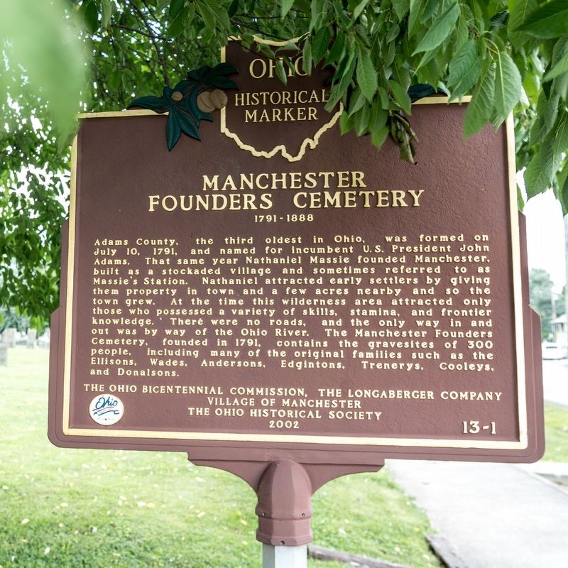
Manchester Founders Cemetery side or marker
GEOGRAPHIC SORT Title Sort Marker Number Sort Marker Number Sort N Marker Number Sort T Publication Order Sort Publication Order Sort A Erected Year Sort Most Viewed Sort Most Recent-Interest Sort Most Recently Changed Sort SEE FAQ #33 FOR DESCRIPTIONS
On 2nd Street (U.S. 52) west of Jack Roush Way, on the right when traveling west. Reported missing.
Near East 8th Street, 0.2 miles east of Cemetery Street, on the right when traveling east.
Near East 8th Street, 0.2 miles east of Cemetery Street, on the right when traveling east.
On East Front Street at Pike Avenue, on the right when traveling east on East Front Street.
On West Front Street at Pearl Street, on the right when traveling west on West Front Street.
On 2nd Street (U.S. 52) east of Cemetery Street, on the right when traveling east.
On North Main Street (Ohio Route 41) near Elliott Avenue, on the right when traveling north. Reported missing.
On Ohio River Scenic Byway (U.S. 52) 0.3 miles west of Blue Creek Road (County Highway 18), on the right when traveling west.
On Main Street (Ohio Route 247) south of Tri County Road, on the right when traveling south.
On West Main Street (Ohio Route 41) at North Cherry Street, on the right when traveling west on West Main Street.
On Second Street (Ohio Route 247) at East Walnut, on the left when traveling south on Second Street.
On West South Street at South West Street, on the left when traveling west on West South Street.
On Zane Trace (Ohio Route 41), on the right when traveling south.
On Main Street (Ohio Route 136) at Dorsey Road (Local Route 48) on Main Street.
On Ohio River Scenic Byway (U.S. 52) 1.5 miles west of State Highway 247, on the right when traveling west.
Paid Advertisement
On Bentley Road near Riley Street, on the right when traveling south.
On East Elm Street east of North Main Street, on the left when traveling east.
On North Main Street south of West 3rd Street, on the right when traveling south.
On Lincoln Highway (Ohio Route 66) just west of North Main Street (Ohio Route 66), on the left when traveling east.
On Allentown Road (Ohio Route 81) west of Poling Road, on the right when traveling west.
Near Zurmehly Road, 0.1 miles east of Beeler Road.
On West Hume Road, 0.5 miles west of Shawnee Road.
On Lincoln Highway (U.S. 30), on the right when traveling west.
On Napoleon Road, 0.2 miles north of West 1st Street, on the right when traveling south.
On North Wanut Street at West 2nd Street, on the right when traveling north on North Wanut Street.
On Defiance Trail North north of Allentown Road (Ohio Route 81), on the left when traveling north.
On Lafayette Road, 0.1 miles north of Ada Road (Ohio Route 81), on the right when traveling north.
On Main Street at North Street (Ohio Route 81), on the right when traveling south on Main Street.
On Bluelick Road, 0.2 miles east of North Main Street (Ohio Route 65), on the right when traveling west.
On South Main Street at Circular Street, on the right when traveling north on South Main Street.
On Eastown Road, on the left when traveling north.
Paid Advertisement
On Ottawa Road (Ohio Route 65) at North West Street (Ohio Route 115), in the median on Ottawa Road.
On Central Avenue (Ohio Route 309) at High Street, on the right when traveling north on Central Avenue.
On Market Street/Bellefontaine Avenue at the Ottawa River, on the left when traveling east on Market Street/Bellefontaine Avenue.
On North West Street (Ohio Route 68) at West Chapman Road, on the right when traveling south on North West Street.
On Shawnee Road, 0.1 miles north of Zimmehly Road, on the right when traveling north.
Near Shawnee Road. Reported missing.
On Central Avenue, on the right when traveling north.
On Bluelick Road, 0.1 miles west of Sugar Street, on the right when traveling west.
On Thayer Road at Mirror Lake Drive, on the left when traveling north on Thayer Road.
On Rockport Road, on the left when traveling west.
On Fort Amanda Road at Sunderland Road, on the right when traveling west on Fort Amanda Road.
On South Broadway Street (Ohio Route 66) north of Wurster Drive, on the right when traveling north.
On Defiance Trail, on the right when traveling north. Reported missing.
On South Broadway Street (Ohio Route 66) at East 3rd Street, on the right when traveling south on South Broadway Street.
On 2nd Street at Cottage Street (Ohio Route 60/511), on the right when traveling west on 2nd Street.
On Ohio Route 603, on the right when traveling south.
Paid Advertisement
On South Market Street (Ohio Route 3) just south of West Main Street (Ohio Route 39), on the right when traveling south.
On South Market Street (Ohio Route 3) south of West Main Street (Ohio Route 39), on the right when traveling south.
On Lincoln Highway (County Route 30A) at Iowa Street, on the right when traveling west on Lincoln Highway.
On Ohio Route 39, on the right when traveling west.
On North Main Street (U.S. 250) at East Main Street, on the right when traveling north on North Main Street.
On East Prospect Road (U.S. 20) at State Road, on the right when traveling east on East Prospect Road.
On Walnut Boulevard east of Hulbert Avenue, on the right when traveling east.
On East Main Road (U.S. 20), on the right when traveling east.
Near Main Street at Broad Street.
On South Broadway (Ohio Route 534) south of Greenridge Drive, on the right when traveling south.
Near South Ridge Road (Ohio Route 84) at County Line Road.
On U.S. 322 west of Ohio Route 193, on the right when traveling east.
On Clinton Street at Washington Road, on the right when traveling west on Clinton Street.
On State Street (Ohio Route 550), on the left when traveling east on State Street.
On State Street (Ohio Route 550), on the right when traveling east.
On East Washington Street, 0.1 miles east of North Court Street, on the left when traveling east.
Paid Advertisement
On Court Street at Washington Street, on the left when traveling north on Court Street.
On Fisher Road (County Road 17) 0.1 miles west of University Heights Drive, on the right when traveling west.
On Union Street at Court Street, on the right when traveling east on Union Street.
On South Shafer Street just east of Richland Avenue, on the left when traveling east.
On Canal Street (U.S. 33) at Pine Grove Drive, on the right when traveling east on Canal Street.
On West Washington Street at Fort Street, on the left when traveling east on West Washington Street.
On National Road (County Road 208) at North Dixie Highway (County Road 25A), on the right when traveling west on National Road.
On Main Street at the CSX railroad tracks, on the left when traveling west on Main Street.
On East Main Street east of South Water Street, on the right when traveling east.
On East Main Street east of South Water Street, on the right when traveling east.
On Dixie Highway south of Coon South Lane, on the right when traveling north.
On Ohio Route 66 at County Route 182, on the left when traveling south on State Route 66.
On East 4th Street west of North Lincoln Street, on the right when traveling west.
On West 4th Street west of North Frankfurt Street, on the right when traveling east.
On West 4th Street west of North Frankfurt Street, on the right when traveling west.
On West 4th Street west of North Frankfurt Street, on the right when traveling west.
Paid Advertisement
On 4th Street at Main Street, on the right when traveling west on 4th Street.
On West 4th Street west of North Frankfort Street, on the right when traveling west.
On Main Street (Ohio Route 66) 0.1 miles south of Bensman Road (U.S. 40), on the right when traveling south.
On Ohio Route 119 east of North Paris Street, on the right when traveling west.
On East 4th Street at South Lincoln Street, on the left when traveling west on East 4th Street.
On West 4th Street west of North Frankfurt Street, on the right when traveling west.
On North Lincoln Drive, on the right when traveling north.
On Southgate Drive, on the right when traveling north.
On Moulton- New Knoxville Road (County Route 91) at Co Rd 33A Plank Pike (County Route 33A), on the left when traveling south on Moulton- New Knoxville Road.
On South Washington Street (Ohio Route 66) at East Front Street, on the right when traveling north on South Washington Street.
On West Monroe Street (Ohio Route 274) at South Washington Street (Ohio Route 66), on the right when traveling east on West Monroe Street.
On East Plum at Canal Street, on the right when traveling west on East Plum.
Near Lock 2 Road (County Road 70) east of Quelhorst Road, on the right when traveling east.
On East German Street west of South Mill Street, on the right when traveling east.
On North Main Street (Ohio Route 29) at East Bremen Street, on the left when traveling north on North Main Street.
On North Main Street at East Bremen Street, on the left when traveling north on North Main Street.
Paid Advertisement
On South St. Marys Street north of West German Street, on the right when traveling south.
On Center Street west of Walnut Street, on the left when traveling west.
On West Spring Street (Ohio Route 703) east of South Wayne Street.
Near East Greenville Road, 0.3 miles east of South Main Street (Ohio Route 66), on the right when traveling west.
Near East Spring Street (Ohio Route 29) west of South Chestnut Street, on the right when traveling east.
1362 entries matched your criteria. The first 100 are listed above.
Next 100 ⊳