On North 19th Street at 4th Avenue North, on the right when traveling north on North 19th Street.
Built in the 1940S, 4th Ave. N. & 19th St. N.
On Mother's Day in 1961, the Freedom Riders, Black and White
members of the Congress for Racial Equality (CORE), arrived at
Birmingham's Trailways bus station. Though integrated . . . — — Map (db m187994) HM
On Center Street south of 9th Avenue West, on the right when traveling south.
1936
Slum clearance became another facial zoning
Weapon. City health officials described. "Negro
quarters” as the unsanitary source of diseases that
threatened community health: Civic leaders used this
reasoning to win millions in federal . . . — — Map (db m189164) HM
On 19th Street North at 5th Avenue North, on the left when traveling north on 19th Street North.
C28 Side
Built 1921, 1800 5th Ave. N.
Lawyers like Arthur Shores and Thurgood Marshall (shown
with Autherine Lucy, the first Black student to integrate the
University of Alabama) filed numerous lawsuits challenging
racial . . . — — Map (db m188003) HM
On 2nd Avenue West east of 12th Street West, on the right when traveling east.
On Aug. 18, 1915, Alabama
Equal Suffrage Association
and Birmingham Barons
hosted suffrage day here in
support of women's suffrage — — Map (db m188885) HM
Bull Connor ordered the fearless "Child Crusaders" to be blasted with high-pressure fire hoses, and he once again loosed the dogs on the young demonstrators. When the media finally exposed the nation to the cruel scene, President John F. Kennedy . . . — — Map (db m73019) HM
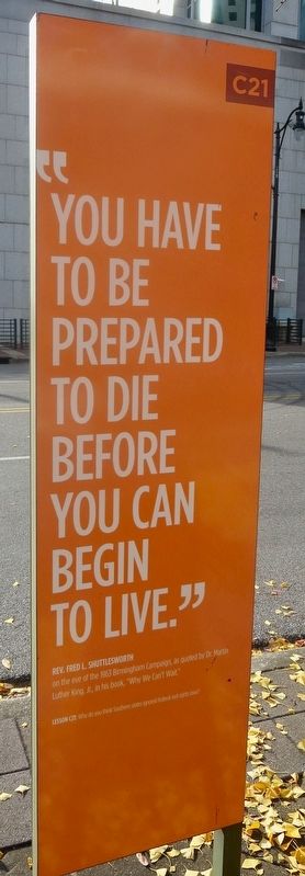
On 19th Street North at 3rd Avenue North, on the right when traveling south on 19th Street North.
For seven years before the 1963 Birmingham Campaign, Rev. Shuttlesworth
and other leaders of the ACMHR taught masses of Black citizens how
to take direct but non-violent actions to gain first-class American
citizenship. Inspired by faith, these . . . — — Map (db m187787) HM
On Tarrant Huffman Road at Marshall Avenue, on the left when traveling west on Tarrant Huffman Road.
Mt. Zion Baptist Church began burying here in the mid-1800s. On June 2, 1970, New Grace Hill Cemetery, Inc., a subsidiary of the Booker T. Washington Insurance Company in Birmingham, purchased this cemetery and officially named it Zion Memorial . . . — — Map (db m35602) HM
On 21st Way South south of Highland Avenue, on the right when traveling south.
Congregation Beth-El was founded in 1907 on Birmingham's north side. Its leadership came from Knesseth Israel, the city's Orthodox Jewish congregation. Beth-El was established as a modern. yet traditional congregation. Construction on the synagogue . . . — — Map (db m216067) HM
On Woodward Street at Huntsville Avenue on Woodward Street.
Lynching In America.
Thousands of black people were the victims of lynching and racial violence in the United States between 1877 and 1950. The lynching of African Americans during this era was a form of racial terrorism intended to intimidate . . . — — Map (db m101159) HM
Near Myron Massey Boulevard north of 55th Street, on the left when traveling north.
Miles College Leaders. Students Active During Civil Rights Era
The Colored Methodist Episcopal Church founded Miles College in
Fairfield in 1898. During the 1960s, President Lucius Pitts
encouraged students, faculty and staff to become . . . — — Map (db m153232) HM
On North 1st Street north of 19th Street North, on the right when traveling north.
Racial Terrorism and Criminal Justice
Racial terror lynching between 1865 and 1950 claimed the lives of thousands of African Americans and created a legacy of injustice that can still be felt today. After emancipation, white Southerners . . . — — Map (db m167223) HM
African Americans, through enslavement and Jim Crow, constructed campus buildings and worked at the University of North Alabama since its beginnings in 1830, yet they were denied admission as students for 133 years. In 1963, Wendell Wilkie Gunn . . . — — Map (db m156930) HM
Near Hightower Place near Veterans Drive (Alabama Route 133), on the left when traveling south.
Recipient of 1989 of the first Kodak Award for Photojournalism, Charles Moore chronicled such major events as the Civil Rights Movement in the 1960's South, political violence in Haiti, and the air war in Vietnam. — — Map (db m219326) HM
Near South Court Street at Canal Street, on the right when traveling south.
Toward the end of the 19th Century, the U.S. government decided that Native Americans should integrate into American culture and give up tribal sovereignty.
The Dawes Allotment Act forced Native Americans to register on what became known as . . . — — Map (db m212215) HM
On N. Pine Street at W. Tennessee St on N. Pine Street.
Dred Scott, whose name is associated with the landmark U.S. Supreme Court Dred Scott Decision of 1857, was born in Virginia between 1795-1809. In 1818 he was in Madison County, Alabama. He came to Florence with the Peter Blow family in 1820. About . . . — — Map (db m35183) HM
Near Hightower Place south of Veterans Drive (Alabama Route 133), on the left when traveling south.
A keen observer and researcher of the Civil Rights Movement in the South, Hank Klibanoff won the Pulitzer Prize in 2007 for The Race Beat: The Press, the Civil Rights Struggle, and the Awakening of a Nation. — — Map (db m219181) HM
On Market Street (Alabama Route 33) at College Street, on the right when traveling south on Market Street.
A scientist of national fame, Peters (1810-1888) lived for many years in Moulton with his wife Naomi (Leetch), a relative of President James K. Polk, who possibly visited here. A man of many talents, Peters was a noted linguist, early civil rights . . . — — Map (db m69670) HM
The first African American student entered the library to register at Auburn University at this site. Acting on a court order, Auburn president Ralph Brown Draughon accepted the application of Harold Franklin as the first African American student in . . . — — Map (db m90861) HM
On South 9th Street south of Avenue A, on the left when traveling south.
Lynching in America
After the Civil War, the ideology of white supremacy led to violent
resistance to equal rights for Black people. Lynching emerged to enforce
racial hierarchy through arbitrary and deadly violence that terrorized
all . . . — — Map (db m176380) HM
On South Commerce Street (Alabama Route 97) at East Lafayette Street, on the right when traveling north on South Commerce Street.
Johnathan Daniels was murdered near
this spot, then Cash's Store, on
August 20, 1965.
He gave his life in the fight for
integration of the churches
and universal voter registration.
At the time, he
was a divinity student at
The . . . — — Map (db m147604) HM
On East Lafayette Street at South Washington Street, on the left when traveling east on East Lafayette Street.
Lynching in America
Between the end of the Civil War and the close of World War II,
white mobs killed thousands of Black Americans in racial terror
lynchings, and committed widespread violence that traumatized
millions more. The Lowndes . . . — — Map (db m235867) HM
On South Commerce Street (Alabama Route 97) south of Oak Street, on the right when traveling south.
On August 20, 1965, Jonathan Myrick Daniels, a 26-year-old
Episcopal seminarian from Keene, New Hampshire, was shot dead
at point blank range here. He was a graduate of Virginia Military
Institute and was attending Episcopal Theological School, . . . — — Map (db m147601) HM
On U.S. 80 at milepost 114 at Steel Haven Road, on the right when traveling east on U.S. 80.
Lowndesboro, AL—Enraged whites, jealous over the business success of a Negro are believed to be the lynchers of Elmore Bolling. Bolling, 39, was found riddled with shot gun and pistol shots 150 yards from his general merchandise store. It is . . . — — Map (db m184279) HM
On U.S. 80 at milepost 111,, 2.2 miles west of County Road 29, on the right when traveling east.
In memory of our sister Viola Liuzzo who gave her life in the struggle for the right to vote... March 25, 1965 Presented by SCLC/WOMEN Evelyn G. Lowery, National Convener - 1991 - The Southern Christian Leadership Conference Joseph E. . . . — — Map (db m85461) HM
On Snow Hill Drive at Alabama Route 21, on the right when traveling west on Snow Hill Drive.
Enslavement & Racial Terror
The enslavement of black people in the United States was a brutal,
dehumanizing system that lasted more than 200 years. Between 1819
and 1860, Alabama's enslaved population grew from 40,000 to 435,000.
According . . . — — Map (db m154554) HM
Threatened by the potential four-to-one advantage of the black vote, whites retaliated by ousting black families from white-owned lands. The African American families who lived here paid dearly to earn their right to vote. Crowded into canvas tents . . . — — Map (db m112400) HM
Since the federal registrars came in August of 1965, thousands and thousands of Negroes have registered to vote. White plantation owners have retaliated by mass evictions. In December 1965, over forty families either left the county, moved in . . . — — Map (db m112405) HM
Monday, March 22, 1965, on the second day of the Selma to Montgomery Voting Rights March, protesters passed this site in late afternoon. At that time the four-lane highway in front of you was only two lanes, and for safety reasons the number of . . . — — Map (db m112375) HM
At times history and fate meet at a single time in a single place to shape a turning point in man's unending search for freedom. So it was at Lexington and Concord. So it was a century ago at Appomattox. So it was last week in Selma, Alabama. . . . — — Map (db m112403) HM
While helicopters buzzed overhead, National Guard soldiers—ordered by President Lyndon Johnson to protect the marchers—lined U.S. Highway 80, alert to the potential of violence by angry whites. Marchers walked mile after tired mile, while black . . . — — Map (db m112384) HM
On U.S. 80 at Trickum Cutoff Road, on the right when traveling west on U.S. 80.
The roots of this house of worship date to 1868 when 26 African American members of Mount Gilead Church left to form their own congregation. The present building was constructed in 1901, with several enlargements and renovations throughout the . . . — — Map (db m104068) HM
For African Americans in the 1960s, being kicked off white-owned lands for trying to register to vote no isolated incident. Just as had happened here in Lowndes County, blacks in Tennessee, Mississippi, and Greene County, Alabama, were driven from . . . — — Map (db m112389) HM
In December 1965, a city of tents appeared on this site. The temporary shelters were homes for evicted black sharecropper families. These farmers worked and lived their lives on white-owned farms in Lowndes County. But when they dared to register to . . . — — Map (db m112371) HM
Near Old Federal Road (County Road 8) 0.1 miles west of Deer Run Trail, on the left when traveling west.
Shorter was originally called Cross Keys for the birthplace in South Carolina of an early settler, J.H. Howard. It was later named Shorter for former Alabama Governor John Gill Shorter. The town embodies the memories of the proud Creek Indian . . . — — Map (db m85463) HM
On Westside Street south of West Northside Street, on the left when traveling south.
In 1957, local government officials in Tuskegee, Alabama sought to gerrymander the city's limits in an attempt to diminish the number of black votes in upcoming elections. Alabama state senator Sam Engelhardt sponsored Act 140, which transformed . . . — — Map (db m139876) HM
On West Montgomery Road east of Peyton Road, on the right when traveling west. Reported missing.
Churches within the African American community played an important role during the civil rights movement. They were places beyond control of white power structure, as well as locations where people could express themselves without reprisal. They . . . — — Map (db m139884) HM
On Westside Street at West Northside Street, on the right when traveling south on Westside Street.
Tuskegee consists of 80 square miles and is the county seat of Macon County, Alabama. Tuskegee rests in the heart of the rural Alabama Black Belt and is 40 miles east of Montgomery. Tuskegee was founded by General Thomas S. Woodward in 1833 after he . . . — — Map (db m99679) HM
On North Church Street north of West Martin Luther King Highway (U.S. 80), on the left when traveling north.
Before the mid-1960s, Tuskegee’s black population faced many challenges when attempting to register to vote. Furthermore, the State of Alabama redrew the town’s political boundaries in an effort to prevent registered blacks from voting in local . . . — — Map (db m69048) HM
On Cedar Street south of Railroad Avenue, on the right when traveling north.
Mount Olive Missionary Baptist Church developed out of the Tuskegee Baptist Church, originally organized in 1842. Although both whites and blacks (slaves) initially worshipped at the same location, the white congregants built a new facility in 1858, . . . — — Map (db m139880) HM
On West Martin Luther King Highway (U.S. 80) west of South Jericho Street, on the right when traveling east.
Rosa Louise McCauley Parks (1913 – 2005) was an iconic activist during the mid twentieth century civil rights movement. Born in Tuskegee, Parks later moved with her mother to Pine Level located near Montgomery, Alabama. She was encouraged by . . . — — Map (db m134670) HM
On East Martin Luther King Highway (U.S. 80) east of North Maple Street, on the left when traveling east.
Samuel "Sammy" Leamon Younge, Jr. (1944-1966), a civil rights and voting rights activist, was the first African American university student killed during the civil rights movement. A Tuskegee native, Younge was attending Tuskegee University when . . . — — Map (db m139875) HM
On South Main Street (U.S. 29) at East Price Street, on the right when traveling north on South Main Street.
In August of 1963, the United States District Court M. D. Alabama sided with the plaintiff in Lee v. Macon County Board of Education. This pivotal civil rights case involved the integration of, the all-white Tuskegee High School (located on . . . — — Map (db m139878) HM
On North Elm Street north of West Northside Street, on the left when traveling north. Reported missing.
Following World War II, Tuskegee's black population began to grow, and many sought to register to vote. Perceiving a threat to their political power, white politicians tried to control the black vote through a variety of techniques. These actions . . . — — Map (db m139877) HM
On Franklin Road near Boy Scout Circle, on the left when traveling north.
Amelia Boynton Robinson (1911 2015) was a voting rights activist and civil rights icon. Born on August 18, 1911, in Savannah, Georgia, she received her bachelor's degree in home economics from Tuskegee University in 1927. In 1934, Mrs. Boynton . . . — — Map (db m139890) HM
On Bibb Street, 0.2 miles north of Hudson Street, on the left when traveling north.
Charles Goode Gomillion (1900-1995) was born on April 1, 1900, in Johnston, South Carolina. He joined the faculty at Tuskegee University in 1928, where he served as dean of students and chair of the social sciences department. He was president of . . . — — Map (db m140006) HM
On West Montgomery Road at Kelly Drive on West Montgomery Road.
Side 1
Born in 1930 in Montgomery, Gray was among the foremost civil rights attorneys of the 20th century. Forced by segregation to leave Alabama to attend law school, he vowed to return and "destroy everything segregated I could find." . . . — — Map (db m101898) HM
On NW Chambliss Street south of West Montgomery Road, on the left when traveling south.
Jessie Parkhurst Guzman (1898-1996) was born in Savannah, Georgia, educated at Howard University (BA, 1919) and Columbia University (MA, 1924), and worked at Tuskegee University for over forty years. During Guzman's time at Tuskegee University, she . . . — — Map (db m139885) HM
On University Avenue east of Booker T Washington Boulevard, on the right when traveling east.
The Tuskegee Institute Advancement League (TIAL) was a student-based organization started in 1963 and reorganized in 1965 during the school integration crises. It originally sought to gain a measure of academic freedom through input with the . . . — — Map (db m139886) HM
On West Montgomery Road at Chambliss Street, on the left when traveling west on West Montgomery Road.
The Tuskegee Civic Association, whose offices were located here, started out of The Men’s Meeting of the 1920s and the Tuskegee Men’s Club of the 1930s. On April 13, 1941, in order to increase its effectiveness and to embrace all segments of the . . . — — Map (db m139923) HM
On University Avenue at Tuskegee Airmen Circle, on the right when traveling east on University Avenue.
I determined when quite a small child . . . I would in some way get enough education to enable me to read common books and newspapers.
—Booker T. Washington, Up From Slavery
Booker T. Washington changed the . . . — — Map (db m101932) HM
Near Davis Circle SW east of Monroe Street SW, on the right when traveling east.
Ratified in 1920, the 19th Amendment to the U.S. Constitution guaranteed women the right to vote. To register to vote in Alabama citizens were required to meet a series of residency and property requirements, pass a literacy test, and pay a poll . . . — — Map (db m191678) HM
On McClung Avenue SE, on the right when traveling east.
Ratified in 1920, the Nineteenth Amendment to the U.S. Constitution guaranteed women the right to vote. The Twickenham Town Chapter, NSDAR honors the history of Huntsville's pioneer suffragists, who met here at the home of Alberta Chapman Taylor . . . — — Map (db m160637) HM
On Church Street Northwest, on the right when traveling north.
Side A
Dr. Joseph Echols Lowery was born in Huntsville on Oct 6, 1921, to Dora and Leroy Lowery. He grew up in Lakeside (Methodist) church. He began his education in Huntsville, spent his middle school years in Chicago, and returned to . . . — — Map (db m85550) HM
On Church Street NW at Monroe Street NW, on the left when traveling north on Church Street NW.
St. John African Methodist Episcopal Church in Huntsville was organized by Dr. William Hooper Councill and others in 1885. Dr. Councill was an ordained elder in the African Methodist Episcopal Church and the founder and first president of Alabama . . . — — Map (db m234323) HM
On Beasley Avenue Northwest at Magnolia Drive Northwest, on the right when traveling west on Beasley Avenue Northwest.
The first integrated elementary education classes in the state of Alabama took place quietly and peacefully here September 3, 1963.
St. Joseph's Mission, church and school, was founded by the Society of the Divine Savior (Salvatorians) to serve . . . — — Map (db m154263) HM
On Greene Street SE at Randolph Avenue SE, on the left when traveling south on Greene Street SE.
Huntsville Equal Suffrage Association reorganized here in 1912. In 1914, Alabama Equal Suffrage Association held convention here. — — Map (db m191649) HM
On Government Boulevard (U.S. 90) 0.5 miles west of Ramsey Road, on the right when traveling west.
The Grand Bay Elementary School for Colored was located on land adjacent to this building. Peter Alba donated the parcel on which the school was constructed in 1919. Soon thereafter, Black residents of Grand Bay and the Board of School . . . — — Map (db m189763) HM
On Dauphin Street, 0.1 miles South Warren Street, on the right when traveling east.
Dr. Williams opened one of the early African-American drugstores- Live and Let Live on this site in 1901. Born on a sugar plantation in Louisiana, he graduated from Meharry Medical School in 1900 and was the second black physician to practice . . . — — Map (db m86393) HM
On Government Street (U.S. 90) east of South Jefferson Street, on the right when traveling east.
Eugenie Marx first president Mobile Equal Suffrage Assn. Educated and organized Mobile women to fight for the right to vote. Lived here 1910-1915. — — Map (db m226705) HM
On Martin Luther King Jr. Avenue at Tunstall Street, on the right when traveling north on Martin Luther King Jr. Avenue.
John L. Finley Jr. opened Finley's Pharmacy #1 in 1950. John and his brother, James, established Finley's #2 in 1959, which was later sold to Benjamin F. Jackson, Sr.
James H. Finley, Sr. eventually opened six stores, launching the first black . . . — — Map (db m151219) HM
A postal worker, a community leader, a state legislator, a journalist, and a civil rights activist, Mobile native John L. LeFlore spent 50 years working to peacefully transform the character of the city and create opportunities to enhance citizens' . . . — — Map (db m111413) HM
On St Francis Street at North Warren Street, on the right when traveling west on St Francis Street.
After the NAACP was outlawed in 1956, LeFlore and the Non-Partisan Voters League took a more active role in civil rights in Mobile. LeFlore served as its director of casework. He was a plaintiff in Bolden vs. Mobile and the judgement changed . . . — — Map (db m86391) HM
On St Joseph Street at St. Louis Street, on the right when traveling south on St Joseph Street.
Judge Virgil Pittman
Thomas Virgil Pittman was born on March 28, 1916, in Enterprise AL. He graduated from the University of Alabama, in 1939 and its School of Law, in 1940. In June 1966, President Lyndon Johnson nominated, and the U.S. . . . — — Map (db m240387) HM
On Church Street near South Royal Street, on the right when traveling west.
Lynching in America
Racial terror lynching claimed the lives of at least 6,500 Black people in the United States between 1865 and 1859. After the Civil War, many white people remained committed to white supremacy and used lethal violence . . . — — Map (db m202593) HM
On Martin Luther King Jr. Avenue at Sengstak Street, on the right when traveling west on Martin Luther King Jr. Avenue.
Organized in 1899 as St. Anthony's Mission by Creoles of African descent. By 1901, Josephite priests Revs. Joseph St. Laurent and Louis Pastorelli had established a small school. The
present church was completed in 1908 and dedicated as Most Pure . . . — — Map (db m111302) HM
On Holt Road (Local Route 1800), on the right when traveling north.
Oaklawn Cemetery is believed to have begun in 1876 as a local family cemetery plot, became a community cemetery by 1879, and expanded into a formally organized cemetery in 1931. Historical and burial information indicates this cemetery primarily . . . — — Map (db m159478) HM
On South Broad Street, 0.1 miles south of Shawnee Street, on the right when traveling south.
Restoring Justice
Henry Williams, Johnny Williams, Ennis Bell, Theodore Wesley Samuels, Prentiss McCann, and Rayfield Davis all died at the height of the segregation era in Mobile. Mobile's Black community protested each of these deaths at the . . . — — Map (db m188735) HM
On Martin Luther King Jr. Avenue at Patton Avenue, on the right when traveling east on Martin Luther King Jr. Avenue.
Vernon Crawford established the first African-American law firm in Mobile. He successfully argued the Birdie Mae Davis case that desegregated Mobile schools. He stood before the Supreme Court and won the landmark case of Bolden vs. the City of . . . — — Map (db m111319) HM
On St. Anthony Street west of North Scott Street, on the right when traveling west.
Side 1
On May 30, 1965, Vivian Malone, became the first African-American to graduate from the University of Alabama. To achieve admission at the all-White university, she was forced to confront then Governor, George C. Wallace, in what has . . . — — Map (db m111392) HM
On Old Pike Road, 0.1 miles north of Cedar Pines Road, on the right when traveling north.
(Obverse)
The Jonesville Community on Old Pike Road in Mathews, named for wealthy landowner George Mathews from Olgethorp County Ga.
was designated by the Montgomery County Commission on October
16th, 2007 to honor the life and legacy . . . — — Map (db m68716) HM
On West Fairview Avenue at Oak Street, on the right when traveling west on West Fairview Avenue.
The City of St Jude, always a refuge for African Americans, hosted the marchers on the last night of their journey. This religious complex—named for the patron saint of impossible situations—housed a school church and hospital and had a 36-acre . . . — — Map (db m91481) HM
On South Bainbridge Street at Dexter Avenue, on the right when traveling north on South Bainbridge Street.
Alabama's First Capitals
On March 3, 1817, Congress designated the town of St. Stephens on the Tombigbee River north of Mobile as capital of the newly formed Alabama Territory. There in 1818, the territorial legislature named Huntsville as the . . . — — Map (db m86063) HM
On Court Street at Market Plaza, on the right when traveling west on Court Street. Reported missing.
At the intersection of Commerce Street and Dexter Avenue, Court Square is arguably the most historic location in America. As the center of 19th century
Southern economic and political power, Montgomery's Court Square was host to a massive slave . . . — — Map (db m91736) HM
On Highland Avenue at Watts Street, on the right when traveling east on Highland Avenue.
Aurelia Eliscera Shines Browder was born January 29, 1919, in Montgomery, Alabama. She graduated with honors in 1956 from Alabama State Teachers College (now Alabama State University).
In April 1955, Browder's refusal to give up . . . — — Map (db m246696) HM
On Oak Street at Robinson Street, on the right when traveling north on Oak Street.
Bell Street Baptist Church was organized on August 12, 1883. Under the leadership of Rev. A. L. Hawkins, the early congregation met in a house in Cooks Alley. In 1922, during Rev. G. R. Hill’s tenure, the congregation moved to a building on . . . — — Map (db m245431) HM
On North Perry Street at Madison Avenue, on the right when traveling north on North Perry Street.
Bernard Whitehurst and the Whitehurst Case
On December 2, 1975, Bernard Whitehurst was shot to death by a police officer in Montgomery, Alabama. He died behind a house on Holcombe Street, running from police officers who mistakenly believed . . . — — Map (db m69366) HM
On Rosa L Parks Avenue at Early Street, on the right when traveling south on Rosa L Parks Avenue. Reported missing.
Bertha Pleasant Williams
First black employee of Montgomery library system, Bertha Pleasant Williams received a high school degree in Fairfield, AL in 1939, a degree from Alabama State College (now ASU) in 1943, and, in 1949, a BLS degree . . . — — Map (db m71388) HM
On Rosa L. Parks Avenue at National Street, on the right when traveling north on Rosa L. Parks Avenue.
Beulah Baptist Church was organized in the home of Monday and Dora Duvall, on the corner of Hull and Winnie Streets. Rev. William (Billy) Jenkins served as the pastor when the first church building was erected on Norton Street. Beulah served as the . . . — — Map (db m71377) HM
On Tullibody Drive at University Drive North, on the right when traveling north on Tullibody Drive.
Side 1
On Dec. 1, 1955, at Alabama State College (now Alabama State University) in a basement room in Councill Hall, the Montgomery Bus Boycott was planned and publicized after the arrest that day of Rosa Parks, who refused to give up . . . — — Map (db m91279) HM
On South Holt Street at Stone Street, on the right when traveling south on South Holt Street.
As the social and cultural epicenters of Montgomery's black
communities in the 1950s and 1960s, black churches also played a
political role, providing sanctuary and strength against discrimination
On December 5, 1955 following the first day of . . . — — Map (db m91464) HM
On South Ripley Street at Adams Avenue, on the right when traveling north on South Ripley Street.
Side 1
Charles O. Harris was born in Tuskegee, Alabama, on August 5, 1852.
He attended Oberlin College in Ohio. Later, in 1870, he became one of
the first students at Howard University in Washington, D.C. Returning
to Alabama during . . . — — Map (db m155110) HM
On South Holt Street, 0.1 miles north of Central Street, on the right when traveling north.
Lucille and Charlie (d. 2/7/78) Times were married on February 3, 1939. Shortly after, the Times' joined the National Association for the Advancement of Colored People (NAACP). Mr. Times received several medals and a Commendation for his service in . . . — — Map (db m81804) HM
On West Fairview Avenue, 0.1 miles west of Oak Street, on the right when traveling west.
(side 1)
City of St. Jude
Founded by Father Harold Purcell in the 1930s, the City of St. Jude included church, school, medical facilities, social center and rectory. Its mission was to provide spiritual, educational, social and . . . — — Map (db m86070) HM
On South Court Street at Adams Avenue, on the right when traveling south on South Court Street.
On May 20, 1961, a group of black and white SNCC members led by John Lewis left Birmingham for Montgomery on a Greyhound bus. They were determined to continue the "Freedom Ride" from Washington, D.C. to New Orleans that had met with violence in . . . — — Map (db m71256) HM
On Rosa L Parks Avenue at Meehan Street, on the right when traveling south on Rosa L Parks Avenue. Reported missing.
On December 1, 1955, Rosa Parks left work and boarded a downtown bus. Her destination was home, Cleveland Court Apartment No. 634. She didn't make it home that day as she was arrested for refusing to surrender her seat to a white man. This single . . . — — Map (db m86074) HM
Near Dexter Avenue at North Bainbridge Street, on the right when traveling west.
Cotton State
Alabama's rapid growth depended on cotton cultivation.
Statehood coincided with improvement of the cotton gin and
increased demand for cotton in British and northern factories.
Within thirty years, Alabama was producing 23 . . . — — Map (db m182595) HM
On Day Street at Davidson Street, on the right when traveling east on Day Street.
Organized from Bethel Baptist Church, congregation founded 1882 with Rev. George Casby as first minister. Originally met in frame building; fund-raising began for this edifice in 1906. Designed by Wallace Rayfield, Tuskegee Institute architect and . . . — — Map (db m71081) HM
On Dexter Avenue at S Decatur Street, on the left when traveling west on Dexter Avenue.
The second black Baptist Church in Montgomery. First pastor was Rev. C. O. Boothe. Present structure built 1885. Designed by Pelham J. Anderson; built by William Watkins, a member of the congregation.
Many prominent black citizens of Montgomery . . . — — Map (db m25128) HM
On North Perry Street at Madison Avenue, on the right when traveling north on North Perry Street.
Elijah Cook
Educator, Businessman, Lawmaker
Born a slave in Wetumpka in 1833, Elijah Cook became a leader in Montgomery’s African American community. Credited with helping to establish the city’s first school for blacks in the basement . . . — — Map (db m69222) HM
Near Dexter Avenue west of North Bainbridge Street.
Emancipation
The end of the Civil War in April 1865 and ratification of the
13th Amendment to the U.S. Constitution meant the end of
enslavement for approximately four hundred thousand black
Alabamians. Freedmen embraced emancipation by . . . — — Map (db m182603) HM
On North Ripley Street at Columbus Street, on the left when traveling north on North Ripley Street.
Organized in 1866, this pioneering congregation grew out of First Baptist Church, now on Perry Street, where early parishioners had worshipped as slaves. The first building, facing Columbus Street, was erected in 1867. Nathan Ashby served as first . . . — — Map (db m36499) HM
On Mobile Street at Mildred Street, on the right when traveling north on Mobile Street.
Four Points: One of Several Black Business Hubs in Montgomery,
and the Impact of Desegregation on Black Business Districts
The intersection of Mildred and Moore Streets was once
home to Four Points, a thriving black business . . . — — Map (db m91462) HM
On Dexter Avenue at South Hull Street, on the right when traveling east on Dexter Avenue.
Side 1
Born in 1930 in Montgomery, Gray was among the foremost civil rights attorneys of the 20th century. Forced by segregation to leave Alabama to attend law school, he vowed to return and "destroy everything segregated I could find." . . . — — Map (db m80842) HM
On West Jeff Davis Avenue at Bragg Street, on the right when traveling west on West Jeff Davis Avenue.
The foundation of the civil rights movement was based in the grassroots strength of West Montgomery. The historic black communities located along this route provided the leadership and support for over a decade.
Whether it was the clergymen, the . . . — — Map (db m91466) HM
Georgia Gilmore, cited as a “solid energetic boycott participant and supporter.” Lived in this house during the days of the Montgomery Bus Boycott. Once arrested on a bus, Gilmore was ardent in her efforts to raise funds for the Movement . . . — — Map (db m28197) HM
On Lake Street west of Hall Street, on the right when traveling west.
Hale Infirmary
On this site for nearly seven decades stood Hale Infirmary. It was
among 25 hospitals in Alabama, and the first in Montgomery, established during the Black Hospital Movement, an effort to overcome
healthcare inequities for . . . — — Map (db m240686) HM
On Hall Street at Lake Street, on the right when traveling south on Hall Street.
In 1903, forty community members organized Hall Street Baptist
Church. Rev. James Brannon served as the first pastor. The church
played an integral role in Centennial Hill's history and culture and
shone as a beacon for those fighting for Civil . . . — — Map (db m158668) HM