In November of 1776 a party of Spanish explorers and Indian guides passed through this area on their way to the Zuni Mission in what is now New Mexico. Franciscan Fathers, Francisco Atanasio Dominquez and Silvestre Velez De Escalante, had embarked . . . — — Map (db m36577) HM
On East Main Street at South Papago Street, on the right when traveling east on East Main Street.
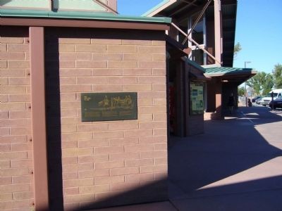
Built of adobe in 1901 with a cast iron front shipped from St. Louis, the ACMI was a branch of the Mormon Cooperative Store system for 17 yrs. It later served the community as a saloon, variety store & furniture emporium. — — Map (db m36652) HM
On Apache Street at Supai, on the right when traveling east on Apache Street.
Begun as missions in the late 1800s, Community Presbyterian Church here, and St. Peter's, a block east, moved into these permanent homes built respectively of brick (1918) & adobe (1928). — — Map (db m36384) HM
On North Washington Street (U.S. 180 at milepost 368.7), on the right when traveling west.
The old "Bowery" was the first place of worship used by the members of the Latter Day Saints Church who came to St. Johns in 1879-1880. The Assembly Hall, located on the northwest corner of the public square was erected in 1882. It was built of logs . . . — — Map (db m36586) HM
On East Safford Street near North 6th Street, on the right when traveling west.
In 1881, Nellie Cashman aided in building an adobe structure which served as a combination church and rectory; the first Pastor was Father Emmanuel P. Schneider. Another church was built in 1882 and Bishop John B. Salpointe dedicated it in 1883. The . . . — — Map (db m27916) HM
On North 3rd Street near East Safford Street (Arizona Highway 80), on the left when traveling north.
The First Protestant Church in Arizona Territory under the direction of Endicott Peabody who conducted the first services in this building on June 18, 1882.
The structure is of hand formed adobe brick, stuccoed in 1970 to protect the adobe. The . . . — — Map (db m27920) HM
On West Cherry Avenue at North Beaver Street, on the right when traveling west on West Cherry Avenue.
In 1888, at the insistence of a group of Catholic
Laymen, The First Catholic Church in Flagstaff was built of brick on the south side of town. It was moved in 1911 to a temporary site just west of and across the street from the present permanent . . . — — Map (db m33336) HM
On South San Francisco Street at West Dupont Avenue, on the right when traveling south on South San Francisco Street.
Flagstaff Presbyterian Church
1892 - 1916
Flagstaff Federated Community Church
1916-1927
Mexican Methodist Mission – El Divino Redentor
United Methodist Church 1927-present
The First Presbyterian congregation of Flagstaff . . . — — Map (db m33364) HM
On West Aspen Avenue at North Sitgreaves Street, on the right when traveling west on West Aspen Avenue.
Flagstaff's first congregation was formed by the Methodists in 1883 and they raised the first church five blocks east of here in 1887. In 1906 they moved here and constructed this Gothic style building of locally quarried red sandstone. The . . . — — Map (db m178071) HM
On U.S. 89A at milepost 538, on the right when traveling west.
From 1872 to 1929
principal route of travel
across the Colorado River
to Utah Settlements
First crossing made at the mouth of Paria Creek in 1864 by Jacob Hamblin. Regular ferry established by John Doyle Lee in 1872. Purchased by . . . — — Map (db m41998) HM
John D. Lee settled here in Dec. 1872 and established ferry service thirteen months later. After her husband's death, Warren M. Johnson ran the oar-driven ferry for Emma Lee, 1875 to 1879, when the Church of Jesus Christ of Latter-Day Saints . . . — — Map (db m41997) HM
On Lake Powell Boulevard at Navajo Drive, on the right when traveling north on Lake Powell Boulevard.
Within sight of this place the Franciscan priests Dominguez and Escalante and their ten companions experienced two of the most difficult challenges among many along the 1,800 miles of their epic journey from the Spanish presidio at Santa Fe, New . . . — — Map (db m40324) HM
It took decades of searching for a perfect location before Marguerite Brunswig Staude's inspiring modern Catholic church could be built. The Chapel of the Holy Cross is an extraordinary architectural achievement, designed by architects Anshen & . . . — — Map (db m94811) HM
On North Highway 87 (U.S. 87) 0.1 miles south of Randall Drive (Arizona Route 260), on the left when traveling north.
The Pine Community Center Historic District is listed on the National Register of Historic Places. The historic buildings of the district are the LDS (Latter Day Saints/Mormon) Ward Chapel, built in 1915-1916, the Cultural Hall, completed in 1931, . . . — — Map (db m67416) HM
On West Thatcher Boulevard, on the right when traveling east.
This monument commemorates the sesquicentennial celebration (1847 – 1997) of the Mormon pioneers' arrival into the Salt Lake Valley. The following groups are recognized for their contribution to the settlement of this Gila Valley. Native . . . — — Map (db m61509) HM
On West Church Street, on the right when traveling east.
When Andrew Kimball was called to preside over the St. Joseph Stake in 1898, Church members provided ten acres on which he built this adobe and brick home in 1902. He helped make the 12,000 adobes. His son, Spencer W. Kimball, 12th President of the . . . — — Map (db m61510) HM
On North 58th Drive north of West Glenn Drive, on the right when traveling south.
This property is listed in the
National Register of Historic Places
By the United States Department of the Interior
Listed
January 11, 2006
The First United Methodist Church of Glendale was originally chartered as the Methodist . . . — — Map (db m30475) HM
On South Extension Road at West Main Street, on the right when traveling south on South Extension Road.
[Upper Marker]:
Mormon Church 2nd Alma Chapel meeting house, 1911. Sold, 1954 to Producers Insurance Company. First Campus Mesa Community College, 1963. Converted to a restaurant in 1973.
[Lower Marker]:
This is the site of . . . — — Map (db m49906) HM
On North 83rd Avenue south of West Madison Street, on the right when traveling south.
Pioneers from Peoria, Illinois, settled here in 1886. Others followed, and on April 10, 1892 the Peoria First Presbyterian congregation was chartered. In 1899 parishioners erected this red-brick Gothic Revival church, with arched stained geometric . . . — — Map (db m30400) HM
Before 1875 hundreds of heroic women came to Arizona from the East and South. From this group came Arizona's first schoolteachers and the publisher of the first newspaper.
In 1876 a group of pioneer women and their families came from the north, . . . — — Map (db m27385) HM
Father Albert was a young missionary and teacher to the Mescalero Apaches in New Mexico and other tribes in Arizona.
Father Braun was an Army chaplain in World War I and World War II receiving the Purple Heart and two Silver Stars for his . . . — — Map (db m26830) HM
On East Monroe Street near North 3rd Street, on the right when traveling west.
The first priest ordained in Arizona, Father Edouard Gerard, attended the Catholic people of Phoenix from Florence, Arizona, where he was the pastor of the Church of the Assumption from 1877 to 1885. For many years, Father Gerard was Vicar General . . . — — Map (db m27626) HM
The first meetinghouse in Phoenix for The Church of Jesus Christ of Latter-day Saints (Mormons) was built on this site by the three-hundred-member congregation of the Phoenix Ward. At the time, J. Robert Price was bishop.
Since their beginning . . . — — Map (db m27613) HM
On East Monroe Street east of 3rd Street, on the left when traveling east.
His Holiness Pope John Paul II On September 2, 1985 Solemnly Proclaimed This Church of The Immaculate Conception of The Blessed Virgin Mary To Be A Minor Basilica The Ceremony of Designation December 8, 1985 Most Rev. Robert F. Sanchez . . . — — Map (db m146333) HM
Enter, Rest and Pray
1879 St. Paul's M.E. Church
Globe, Arizona Territory
Reconstructed 1968
By
Mr. & Mrs. Andrew P. Tell
and
The Tell Foundation — — Map (db m39863) HM
On North Brown Avenue at East First Street, on the right when traveling north on North Brown Avenue.
The first Catholic Parish and oldest standing church building in Scottsdale, Arizona. Built by hand by the Mexicans who settled here in the late 1910's. — — Map (db m141345) HM
On East University Drive at South College Avenue, on the right when traveling west on East University Drive.
Built in 1903 with stone from Tempe Butte and dedicated to Mary, the Mother of Jesus, this church is the oldest in the valley.
For decades it was the only Catholic Church in the area and former Pastors include Bishop James Davis of Santa Fe and . . . — — Map (db m49909) HM
Near North Pipe Spring Road, 0.3 miles north of Arizona Route 389, on the left when traveling north.
Pipe Spring, October 1870 to April 1872 — The sound of hammers striking steel drills and chisels rang out on this hillside for more than a year as the walls of Winsor Castle went up. Master stone masons Elijah and Elisha Averett were sent by . . . — — Map (db m149375) HM
Established May 31, 1923
Through effort of Stephen T. Mather and friends
Pipe Springs
Occupied in 1863 by Dr. James M. Whitmore, who, with Robert McIntyre, was killed 4 miles S.E. Of here January 3, 1866 by Navajo and Piute . . . — — Map (db m131296) HM
On North 5th Street at East Spring Street, on the right when traveling north on North 5th Street.
This building has been placed on
The National Register of
Historic Places
By the United States Department of the Interior
St. John’s
United Methodist Church
Built 1917
Constructed of locally quarried tufa stone, this is the . . . — — Map (db m29408) HM
On East Spring Street east of North 3rd Street, on the right when traveling west.
This building has been placed on
The National Register of
Historic Places
By the United States Department of the Interior
St. Mary’s Catholic Church
Built 1906 – 1907
Constructed of locally quarried tufa stone, this . . . — — Map (db m29397) HM
On Center Street at South Main Street, on the right when traveling west on Center Street.
(south side of monument)Jonathan Heaton 1857-1930 Patriarch of MoccasinJonathan was a fair-minded man of faith dedicated to God, family, and his fellowman. He worked tirelessly to establish orchards, fields, gardens, and herds, making . . . — — Map (db m149340) HM
On Center Street at South Main Street, on the right when traveling west on Center Street.
Moccasin Ranch was part of the United Order from 1875-1894. Jonathan Heaton, a man of faith, a builder of homes, churches and towns, then continued to develop the ranch. Many of his descendants still live in this peaceful valley. — — Map (db m149339) HM
On West Center Street at North 2nd Street West, on the right when traveling west on West Center Street.
Born December 2, 1834 in Stockholm, New York, son of Silas and Mary Aikens Smith, and first cousin to the Prophet Joseph Smith, he crossed the great plains to the Salt Lake Valley in 1847 with the Mormon pioneers. Called to help colonize Parowan in . . . — — Map (db m36736) HM
Near East 2nd Street, 0.1 miles east of North Kinsley Avenue.
The Little Colorado River and its tributaries supplied a vital water source to the area's earliest inhabitants and travelers. The watershed sustained the nearby Homol'ovi villages of the Ancestral Puebloans. A passable ford across the river allowed . . . — — Map (db m209669) HM
Near Homolovi State Park Entrance Road, 2.1 miles west of Arizona Route 87.
Family Man
Church Leader
Defender of the Prophets
Colonizer
Friend of the Indians
Stockman
Noted Horseman
Defender of Liberty
In January of 1876, Lot Smith was called by President Brigham Young on a mission to captain one of four . . . — — Map (db m185335) HM
Near Homolovi State Park Entrance Road, 2.1 miles west of Arizona Route 87.
Answering the Church's Call
In January of 1876, Brigham Young, the President of the Church of Jesus Christ of Latter Day Saints, announced his plan to establish Mormon colonies in the Arizona Territory. In the months that followed, more than . . . — — Map (db m185328) HM
Near Homolovi State Park Entrance Road, 2.1 miles west of Arizona Route 87.
This monument marks the cemetery and vicinity of the site of Sunset, a Mormon pioneer settlement founded by Lot Smith in March, 1876. The settlers, part of a colonization group called from Utah to Arizona by Brigham Young, came by way of Lee's . . . — — Map (db m185080) HM
On South Stone Avenue, on the right when traveling south.
Jewish pioneers, among Arizona's earliest settlers, began arriving in the 1850s and for half a century they worshipped in private homes and rented quarters. In 1904, the Hebrew Ladies Aid Society, now the Sisterhood of Temple Emanu-El, . . . — — Map (db m83237) HM
On South Church Avenue at West Broadway Boulevard, on the right when traveling south on South Church Avenue.
Named in 1869 for the convent located adjacent to San Augustín Cathedral. When the seven Sisters of St. Joseph of Carondelet finally arrived in 1870, they opened the city’s first parochial school for girls next to San Augustín. Three years later . . . — — Map (db m69589) HM
On North Church Avenue, on the right when traveling north. Reported missing.
Named in 1869 for the convent located adjacent to San Augustín Cathedral. When the seven Sisters of St. Joseph of Carondelet finally arrived in 1870, they opened the city’s first parochial school for girls next to San Augustín. Three years later . . . — — Map (db m186122) HM
On South Church Avenue at West McCormick Street, on the right when traveling south on South Church Avenue. Reported missing.
Named in 1869 for the convent located adjacent to San Augustín Cathedral. When the seven Sisters of St. Joseph of Carondelet finally arrived in 1870, they opened the city’s first parochial school for girls next to San Augustín. Three years later . . . — — Map (db m186125) HM
Memorial to Francisco Garcés, explorer and first Franciscan missionary to the Pima village at the foot of Sentinel Peak. In 1770 Garcés and the Pimas constructed at that site the first substantial building in Tucson, a mission residence with two . . . — — Map (db m83034) HM
On this site stood the Catedral de San Agustin, the first church near the Tucson Presidio, Arizona Territory. The adobe and stone structure was built under the direction of Bishop Salpointe in 1883. — — Map (db m51618) HM
On this site stood the first Presbyterian Church, and the second Protestant Church in Arizona. It was organized in 1874 for Presbyterian Missions in the Territories by the Reverend Sheldon Jackson and constructed by the Reverend J. A. Anderson, with . . . — — Map (db m83238) HM
On West Alameda Street, on the right when traveling east.
Born Segno, Italy, 1645 – Educated at Jesuit Colleges
Entered society of Jesus, 1665 – His petition to be sent upon
a distant and dangerous mission granted, 1678 – Began missionary labors in Lower California, April 1, 1683 . . . — — Map (db m26394) HM
Near North Campbell Avenue north of East River Road, on the right when traveling north.
This Property
is Listed in the
National Register
of Historic Places
By the United States Department of the Interior
St. Philip's in the Hills
1936 — — Map (db m31524) HM
Mission San Xavier del Bac was founded by the Jesuit missionary, Fr. Eusebio Kino in 1692. The present church was built under the direction of the Franciscans. Construction began in 1783 and was completed in 1797.
The church continues to . . . — — Map (db m83206) HM
Mission San Xavier del Bac was founded by Father Eusebio Kino as a Catholic mission in 1692. This Baroque architecture style building is the oldest intact European structure in Arizona. Construction began in 1783 and was completed in 1797. The . . . — — Map (db m84279) HM
Erected by the Bishop of Tvcson A.D. 1908 The fiftieth anniversary of the wondrovs apparitions of the Blessed Virgin Mother of God at the Grotto of Lovrdes — — Map (db m84278) HM
A tiny chapel, built here in 1915, served the Barriada del Rillito, a community now called El Fuerte. The fifteen immigrant Mexican families of this village gathered outside under mesquite trees to hear Mass. In 1917, Señora Josefa de Mule donated . . . — — Map (db m83018) HM
Santa Cruz Church
built by
Manuel G. Flores
Construction began November 13, 1916
under
His excellency Henry Granjon
Bishop of Tucson
Established as parish February 12, 1919 — — Map (db m84224) HM
Near St. Peters Road, 0.3 miles north of Nelson Road.
Erected Nov. 11, 1945
In Memory of the Men
of St. Peter's Mission
Who served in World War II
* Anthony Jose USA • Felix Kayyittan USA • Leo B. Manuel USA • Leonard Pangott USA • Roger Osife USA •
Albert J Moreno USMC • Chester J . . . — — Map (db m33700) HM
Near West Florence Boulevard near North Sacaton Road.
This fieldstone structure was built in 1927 and served as the First Presbyterian Church until 1970. Rocks used in the construction were gathered from the desert and hauled to town. Renovation of the sanctuary was accomplished in 1984 and now serves . . . — — Map (db m27208) HM
On East 8th Street, on the right when traveling east.
Completed in 1912, the Church of The Assumption is an example of the Mission Revival style of architecture. The third church built for Assumption Parish, it replaced the second church built on this site in 1884, which burned down in 1893. This . . . — — Map (db m26687) HM
On East 8th Street, on the right when traveling east.
This first Catholic Church in central Arizona, built in 1870 by Father Andre Echallier, was called "La Capilla del Gila". In 1883 a larger edifice commemorating the Assumption of the Blessed Virgin Mary, was constructed to the west: a convent was . . . — — Map (db m26689) HM
On East Buttle Avenue near Orlando Street, on the right when traveling east.
This second-oldest Presbyterian Church in continuous usage in Arizona was founded in 1888. The present building was designed by architects Wallingford and Bell of Phoenix in the Spanish Colonial Revival style, with mission-type tile on the roof. . . . — — Map (db m26627) HM
Erected at the foot of the family cemetery in 1958 by descendants of Don Vicente and Doña Rita Pérez Guillen De La Ossa who had voyaged from the Basque area of Spain during the 1800's to what is now Southern California. Their son Don Antonio and his . . . — — Map (db m78425) HM
Near North River Road, 2.2 miles west of East Patagonia Highway (State Highway 82).
This site contains the ruins of Mission Los Santos Angeles de Guevavi, first established by Father Eusebio Francisco Kino in 1691. The property was donated to The Archaeological Conservancy for a permanent Archaeological Preserve by Ralph Wingfield . . . — — Map (db m132642) HM
On Calle Iglesia, on the right when traveling east.
Several Tubac churches have stood on this site. The first, a shelter built by Jesuit missionaries in the early 1700's, was administered from Tumacacori. About 1760 Captain De Anza built a chapel for presidio soldiers. A later church was visited by . . . — — Map (db m27143) HM
On East Frontage Road, on the right when traveling north.
Beginning and History
In January of 1691, at the request of the O'odham (Pima) Indians of the Santa Cruz River Valley, Jesuit Father Eusebio Francisco Kino established the mission of Tumacácori, dedicated to Saint Cajetan (San Cayetano). . . . — — Map (db m68149) HM
On North Marina Street., on the right when traveling south.
In the fall of 1878 the Sisters of St. Joseph came to Prescott. Money was raised in the community for a hospital to be run by the sisters and by 1881 the hospital had been completed on North Marina Street. In June of 1891 construction was started . . . — — Map (db m21603) HM
The Pentecostal Church of Sedona met in 1932 to discuss affiliating with the Assemblies of God – it was June 1933 before the congregation was informed that they had been officially recognized by the General Council. In 1930 Pastor James . . . — — Map (db m133574) HM
Little Horse Park, now called the Chapel area, was originally a mixture of private and US Forest Service property. Lee Piper homestead there and Otto Hallermund held the Forest Service-issued grazing permit for the area – part of the Sedona . . . — — Map (db m133690) HM
Near Prison Hill Road, 0.5 miles north of Harold C. Giss Parkway.
Across the Colorado River is "Indian Hill," the site of La Purisima Concepcion mission. Built in 1780 by Spanish explorers, it was destroyed in 1781 when native Quechans revolted, killing all European males. Nothing is left of that structure. Today . . . — — Map (db m158369) HM
On South Avenue B south of West 5th Street, on the right when traveling north.
In Commemoration
Of the
125th Anniversary of the Founding
of
Immaculate Conception Parish
1866 – 1991
Celebrated on the Feast of the Immaculate Conception
December 8, 1991
Most Rev. Manuel D. Moreno, D.D.
Bishop of . . . — — Map (db m29024) HM
Near West 8th Street, 0.5 miles west of Somerton Avenue.
Mounted on back of monument
Mormon Battalion Crossing
This monument marks the approximate site of the crossing of the Colorado River by the Mormon Battalion on 10 and 11 January 1847.
The Mormon Battalion consisted of 500 . . . — — Map (db m62011) HM