This headland has attracted and challenged centuries of travelers.
For centuries, Siuslaw, Yachats and Alsea Tribes were drawn to the rich marine resources at Heceta Head.
As they hunted, fished, and traveled, they established . . . — — Map (db m113442) HM
The Siuslaw River Bridge was built as part of the Coast Bridges Project.
It is one of five designed by Conde B. McCullough and built during the Great Depression from 1934 to 1936.
The Coast Bridges Project was funded through the Public Works . . . — — Map (db m113260) HM
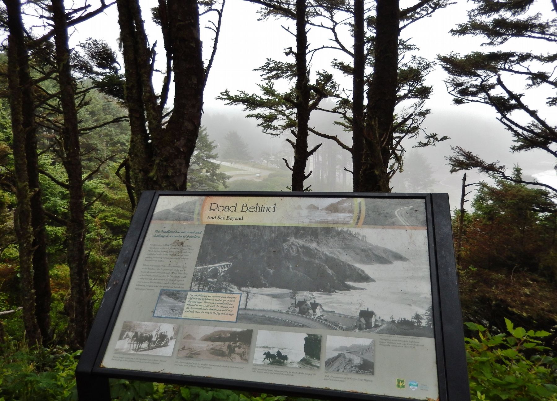
If this historic bridge and tunnel weren’t here, what would it be like to cross Cape Creek?
Engineers building the Pacific Coast Highway in the early 1930s encountered an unusual challenge here at Cape Creek, a deep, offset gorge, . . . — — Map (db m113301) HM
This marks the Old Stage Route and the Daniel Smith Donation Land Claim Homesite 1852 – 1908 Smithfield Dedicated in His Honor 1862 — — Map (db m117049) HM
As Oregon entered the 20th century, travel along the coast was a combination of Indian trails, the beach, and a few very muddy roads. In 1892, Ben Jones led a delegation to Corvallis to seek money for road improvements from the County. The county . . . — — Map (db m177287) HM
Long before today's modern paved highways, rough, muddy wagon roads provided the only inland access to Oregon's coast, and travel north or south was often on the beach at a low tide.
Construction of a continuous coastal road, dubbed the . . . — — Map (db m113501) HM
(Note: marker is comprised of four panels)(top left panel)
The rugged shore of the Central and Northern Oregon Coast is backed by the Coast Range Mountains, remnants of a chain of volcanic islands that collided with the North . . . — — Map (db m177132) HM
Automobile history was made here June 20, 1905, when the first car to cross the Cascade Mountains conquered the Santiam Wagon Road. Dwight Huss drove "Old Scout," a 1904 Oldsmobile Curved Dash Runabout, from New York to Portland in 44 days. "Old . . . — — Map (db m113674) HM
The pass located east of here through the Cascade Range was once called Wiley Pass after Andrew Wiley. Wiley with other Willamette Valley Pioneers explored it in 1859 while searching for a route to move their livestock to the grasslands of central . . . — — Map (db m113671) HM
During the late 19th century thousands of Americans left farms, families and friends to trek the Oregon Trail toward new lives in the West. The trail was nearly 2,000 miles across prairies, mountains and parched deserts. Contrary to popular belief, . . . — — Map (db m106941) HM
extended from mouth of Jordan Creek to Silver City. Franchised in 1866 the road ran to the east from here. Part of U.S. 95 west of Jordan Valley lies on old road-bed. — — Map (db m106886) HM
(Inside the kiosk are seven panels which deal with Fort Boise and the Snake River Crossing.)
"Pathway to the "Garden of the World"
Excitement filled the air May 22, 1843 as nearly one thousand Americans left Missouri . . . — — Map (db m106947) HM
Overland emigration between 1840 and 1863 brought over 50,000 pioneers to Oregon. Seven miles west of Malheur Butte, weary Oregon Trail emigrants camped at the Malheur River crossing, taking advantage of local hot springs and the first good water . . . — — Map (db m107208) HM
(The Oregon Trail kiosk houses thirteen panels which deal with Native Americans, the Fur Trade, the Oregon Question, Oregon Fever, and trials of the Oregon Trail.)
Pathway to the "Garden of the World"
Excitement filled the . . . — — Map (db m107234) HM
Eager to save time on the Oregon Trail, emigrants often attempted shortcuts. Between 1845 and 1854, three wagon trains left this campsite seeking a cutoff to the Willamette Valley.
The Meek Cutoff of 1845
Frontiersman Stephen . . . — — Map (db m107076) HM
Imagine traveling on the Oregon Trail. You woke this morning beside the Snake River. Tonight’s camp will be on the Malheur River.
Sniff the fragrance as wagon wheels roll over the sagebrush and send its pungent aroma into the air. Inhale the . . . — — Map (db m107032) HM
From the 1830s to the completion of the transcontinental railroad in 1869, the Oregon Trail was the way west for thousands of restless Americans from all walks of life.
Fired with a hope of finding a better life, more than 250,000 people . . . — — Map (db m107034) HM
In 1845 Meek led 200 families away from Oregon Trail seeking a shorter route west. Gold found enroute began Blue Bucket legend. Hardships drove train back to Oregon Trail at The Dalles. — — Map (db m207961) HM
(Three panels are mounted on a common support)
Under the Wagon Cover
By the time the pioneers reached this point in their journey, many supplies had been exhausted or discarded to lighten their load. Many who had depended . . . — — Map (db m107038) HM
(Inside this kiosk are seven panels which deal with the Malheur River and Meek's Cutoff.
"Pathway to the "Garden of the World"
Excitement filled the air May 22, 1843 as nearly one thousand Americans left Missouri . . . — — Map (db m107077) HM
Fourmile Canyon witnessed the westward passage of wagons across the Columbia Plateau during the late summer and early fall. By this time on their journey, the emigrants had alternately been exposed to blazing heat, bitter cold and blustery winds. In . . . — — Map (db m111943) HM
Testing stamina and patience, the wagons were hurried to maintain constant motion across seemingly barren terrain. Facing trampled and scarce resources, the emigrants were often forced to wander miles off the established trail in search of water, . . . — — Map (db m111944) HM
The Oregon Trail crossing of Willow Creek was an important site on the trail. There was water and forage for the pioneers and their livestock. This was often a location for a layover to rest and equipment repair before pushing on to The Dalles and a . . . — — Map (db m111942) HM
Using the sun’s energy, the chlorophyll in a plant’s leaves produce sugars and starches that nourish the plant.
Shafts of light dance briefly through this deep canyon, illuminating shade-tolerant ferns, mosses, and lichens . . . — — Map (db m112252) HM
The US Department of Agriculture describes cedar as possessing a natural resistance to rot…
It is well recognized for its longevity and strength above other wood products.
Oneonta Bluff presented an obstacle to engineer Samuel C. . . . — — Map (db m112251) HM
Demands for a good road paralleling the Columbia River began with emigration along the rugged Oregon Trail in 1843. But it took Samuel Hill and this view to help make the dream a reality.
Sam Hill, an eccentric and wealthy railroad . . . — — Map (db m114071) HM
Stacks of cordwood and bushels of potatoes lined the docks of Corbett Landing in the 1880s.
This riverside steamboat landing and railroad whistle stop served early settlers as a shipping and receiving station for surplus produce and the . . . — — Map (db m113253) HM
Chief Engineer, Scenic Columbia River Highway, 1913–1915.
Pioneer Builder of hard-surface roads. His genius overcame tremendous obstacles, extending and replacing the early trail through the Columbia River gorge with a highway of poetry . . . — — Map (db m86445) HM
Not until this highway was built
was it possible to go up or down
the Columbia River Gorge -
Earliest period rafts and
dug-outs (native boats) –
Later period steamboats
and railroad –
Erected by loving . . . — — Map (db m114072) HM
Originator of ocean going log rafts. Sponsor of the Columbia River Highway. Benefactor of Benson Polytechnic School. Donor of the Benson Tract containing Multnomah Falls, Wahkeena Falls and Benson State Park.
Patern and casting by Benson High . . . — — Map (db m91212) HM
(Seven panels dealing with topics related to the Applegate Trail are found at this kiosk:)
In 1846, Jesse Applegate and fourteen others from near Dallas, Oregon, established a trail south from the Willamette Valley and east to Fort . . . — — Map (db m114352) HM
(Seven panels dealing with the Deschutes River Crossing portion of the Oregon Trail are found at this kiosk)
Truly Heart-Breaking!
Oregon Trail emigrants reached the Columbia River after an arduous trek across the dry and . . . — — Map (db m111990) HM
If driving the highway now is nerve-wracking, imagine traveling through here before it was build! The 1,680-foot high Neahkahnie Mountain is one of the most treacherous headlands on the coast.
Native residents once traveled by canoe or on foot to . . . — — Map (db m113734) HM
During the early development of our national parks (1920s) an evolution in design ethics was taking shape. This design ethic emphasized and organic approach to architecture and landscape - designing in harmony with nature. Nature was the most . . . — — Map (db m113774) HM
You are standing on the west shoulder of Neahkahnie Mountain - at 1,661 feet, it is one of the highest points on Oregon’s coast. The mountain’s name is said to be a Native American word for “home of the supreme being.” This basalt, . . . — — Map (db m113768) HM
Three-quarters of a mile of roadwork added safety and beauty to the Coast Highway flanking Neahkahnie Mountain. Talented masons who had once worked for the Works Progress Administration blasted away tons of rock off the mountainside and built . . . — — Map (db m113735) HM
(Six panels dealing with the Deadman Pass portion of the Oregon Trail are found at this kiosk)
Wagon Ruts
More than 50,000 emigrants traveled west on the Oregon Trail between 1840 and 1850. The constant stream of wagons . . . — — Map (db m111563) HM
The Wagon and Team
Wagons for trail travel were of the simplest construction, they cost $85.00 each. They were light, strong, and carried on sturdy wheels. It was recommended that wheels be made of bois-d'arc, osage orangewood or white . . . — — Map (db m111926) HM
This morning after going one mile, we left the river, five mile over the ridge we crossed the river and encamped for the day in order to recruit our cattle as they were much fatigued by crossing the Blue Mountains. -- William J. . . . — — Map (db m111924) HM
In the first week of January, 1812, a party of trappers and traders, members of the Astor Overland Expedition, crossed the Blue Mountains in this area. Traveling afoot in bitter cold, often waist deep in snow, they were the first white men in this . . . — — Map (db m111534) HM
This corner lot was originally the home of Jeremiah and Nancy Despain - early settlers and developers of Pendleton. Despain Avenue and Despain Gulch are named in their memory. Their house sat on this corner from 1874 until it was torn down to make . . . — — Map (db m111707) HM
This magnificent view is preserved and protected by the efforts of the Oregon Roadside Council, which initiated and secured the passage of the Oregon Scenic Areas Act in 1961. 3585 scenic miles of highways were surveyed and selected by the Council. . . . — — Map (db m111564) HM
This location marks a travel corridor for Plateau Tribes moving seasonally from the Columbia River to the Blue Mountains. In 1811, members of the Astor Party under the leadership of Wilson Price Hunt camped here on their way west. They traded with . . . — — Map (db m111565) HM
(Six panels dealing with the Pendleton area portion of the Oregon Trail are found at this kiosk)
The Long Walk to Oregon
Contrary to popular belief Oregon Trail emigrants rarely took the reins while seated in their . . . — — Map (db m111578) HM
Weary emigrants traveling westward on the Oregon Trail favored a campsite on the near bank of the Umatilla River at this point. On leaving they climbed the same hill the highway now traverses. Then recrossed the Umatilla River at Echo 20 hot dusty . . . — — Map (db m111912) HM
(Six panels dealing with the Umatilla River Crossing portion of the Oregon Trail are found at this kiosk)
The Road Forks
Early Oregon Trail emigrants crossed the Blue Mountains and traveled north to re-provision at the . . . — — Map (db m111940) HM
"Commenced the ascent of the Blue Mountains It is a lovely morning, and all hands seem to be delighted with the prospect, of being so near timber again, after weary months of travel, on the dry dusty sage plants, with nothing to receive the eye; . . . — — Map (db m111491) HM
Native peoples crossed the Blue Mountains long before the first explores and fur trappers.
In 1834, John Kirk Townsend found the Cayuse and Nez Perce, very friendly towards us, each of the chiefs taking us by the hand with great . . . — — Map (db m111490) HM
Lumber was vital to early settlers of the Grande Ronde Valley. In 1890, Smith and Stanley built a large mill in the small town of Perry, Oregon. Operating the first bandsaw in Union County, the large mill at Perry was producing about 20,000,000 . . . — — Map (db m111440) HM
(Six panels dealing with the Blue Mountian portion of the Oregon Trail are found beneath this kiosk)
The Blue Mountains
Oregon Trail emigrants crossed the Rocky Mountains through South Pass in Wyoming. The ascent and . . . — — Map (db m111466) HM
"... we traveled on for the Blue Mountains cutting our way through the fallen timber... We found it very laborious ... with our dull axes that we had not ground since we left Missouri having no grinding stone to grind them & our hands being very . . . — — Map (db m111494) HM
On August 15, 1853 Henry Allyn wrote the following about his second day in the Blue Mountains: "Elizabeth and father still quite unwell ... We noon on the mountain and take our mules down into a doleful cavern and found a little grass and water, . . . — — Map (db m111492) HM
During the mid-1800s, thousands of American emigrants labored along this ridge. Since then, stage coach, train and automobile roads have paralleled the Oregon Trail over these mountains.
Only traces of the original road remain, yet the ideals of . . . — — Map (db m111496) HM
(Twelve panels dealing with Oregon Trail related topics are found at this kiosk)
Pathway to the "Garden of the World"
Excitement filled the air May 22, 1843 as nearly one thousand Americans left Missouri toward new . . . — — Map (db m112193) HM
Nestled bewteen the rainy Cascades and the eastern Oregon deserts, Mosier's unique climate enables hillsides to bloom in a pallet of color.
In the spring, wildflower enthusiasts flock to Mosier for the spectacular array – “the . . . — — Map (db m112254) HM
Today, engineers use high resolution satellite photography and advanced computer modeling software to design roads.
Gazing down upon the graceful, winding Historic Columbia River Highway, it is easy to forget how challenging its . . . — — Map (db m112250) HM
From 1841 until the early 1900's more than 500,000 people traveled over 2,000 miles from Independence, Missouri to The Dalles, Oregon. They had to make a decision at The Dalles for traveling the last 100 miles to the Willamette Valley. They could . . . — — Map (db m112468) HM
Father Nooy, a Catholic priest, and Jack Frank built The Dalles Garage in 1920. In 1922, the Columbia River Highway (U.S. Highway 30) was completed and ran in front of the garage, then known as Lester’s Garage. The building was next occupied by . . . — — Map (db m112074) HM
Tucked along the bluffs above the Columbia River lies a hidden treasure: the Historic Columbia River Highway. This grand road - the first scenic highway in the United States - was built in the early 1900s by engineers and architects eager to create . . . — — Map (db m158537) HM
This area on the Deschutes River has been a river crossing and fishing location for thousands of years. Peter Skene Odgen made note of an Indian camp and bridge when he crossed here in 1826. Early pioneers using the Meek Cutoff passed here on their . . . — — Map (db m112505) HM
"After descending a long, steep, rocky and very tedious hill, we have campt in a valley on the bank of Indian (Tygh) Creek, near some Frenchmen who have a trading post. There are also a good many Indians encamped around us." -- Amelia Stewart . . . — — Map (db m112503) HM
165 entries matched your criteria. Entries 101 through 165 are listed above. ⊲ Previous 100