On Plumtrees Road at Taylor Road, on the right when traveling north on Plumtrees Road.
Plumtrees School
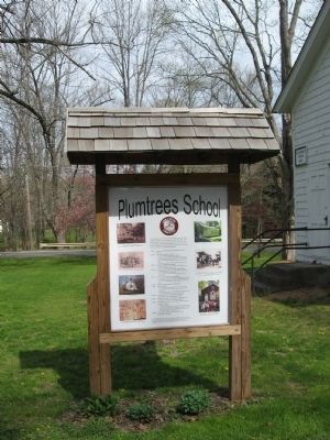
The Plumtrees School was built in 1867 as a one room school house for the Plumtrees District of Bethel. The school served the community from 1867 through 1970. At its closing it was the last operating one room school house in . . . — — Map (db m55006) HM
Near Dewey Street at Maplewood Avenue, on the left when traveling north.
This monument is a memorial to Charles S. Stratton, a native of Bridgeport, who gained worldwide fame as Tom Thumb in the exhibitions of P.T. Barnum. The lifesize statue was erected before Tom Thumb's death on July 15, 1883. In 1959 vandals smashed . . . — — Map (db m27168) HM
On White Street at Main Street, on the right when traveling west on White Street.
Continuing educational opportunities have long been available in Danbury. In the late 1800s, the Stillman’s Business College, at the corner on Main and White Streets, offered classes in penmanship, commercial law and bookkeeping.
The . . . — — Map (db m71136) HM
On South Street at Main Street, on the left when traveling east on South Street.
Historic Site
Danbury’s First Episcopal Church occupied this site from 1763 until 1884. In 1777, British troops, led by General Tryon, took military stores from the church and burned them in the nearby street, but spared the edifice.
Three . . . — — Map (db m72562) HM
On Main Street at State Street, on the left when traveling north on Main Street.
Since its earliest days, the importance of education has been at the forefront of the development of the community. In 1763 the will of Comfort Starr left 800 pounds “for the support of a perpetual school in the centre of town.”
By 1769, a . . . — — Map (db m71477) HM
On Main Street at West Street, on the right when traveling south on Main Street.
In 1771, the Reverend Ebenezer Baldwin drew up terms for a subscription library that would be free to all denominations. Between 1793 and 1856, several other libraries were formed and disbanded.
In 1869 the present Danbury Library was . . . — — Map (db m71244) HM
On Old Kings Highway North south of Pine Brook Lane, on the right when traveling north.
Telling the Story of Darien
Originally founded as the Darien Historical Society in 1953, the Museum of Darien is dedicated to telling the town's story.
Whether it's a 17th-century blanket chest, a hand-sewn Civil War-era flag, or an . . . — — Map (db m230984) HM
Near Old Post Road at Beach Road, on the right when traveling north.
Connecticut's founding Puritans valued education. As early as 1650, towns with 50 or more families were required to teach children to read and write. The goal of education was to teach children how to read so they could gain a moral and spiritual . . . — — Map (db m203400) HM
On Bronson Avenue, 0.1 miles Verna Hill Road, on the right when traveling north.
Site of "Verna"
Home of Timothy Dwight
Chaplain in Continental Army
Pastor of Greenfield
Founder of Academy
Poet of "Greenfield Hill"
President of Yale 1795 - 1815 — — Map (db m27421) HM
On Main Street (Connecticut Route 25) at Purdy Hill Road, on the right when traveling north on Main Street.
Stepney
ca 1830
Stepney Schoolhouse
The one-room district schoolhouse was the cornerstone of CT public education until the 20th century. Students of all ages were taught by one teacher and often supplied their own books & writing slates. This . . . — — Map (db m92003) HM
On Lonetown Road at Hill Road, on the right when traveling south on Lonetown Road.
This tablet is placed to perpetuate the memory of
Aaron Sanford Hill
1800 – 1893
Interest in his native town and in public education inspired him to found
The Hill Academy
Erected on this site in 1883, this building, . . . — — Map (db m26871) HM
On Bailey Avenue at Main Street (Connecticut Route 35), on the left when traveling east on Bailey Avenue. Reported missing.
Louis Bailey (1819-1899), a prominent member of the community, created Bailey Avenue for the purpose of building stores and residences, and for access to the train depot on Prospect St. He was an incorporator of the Ridgefield Savings Bank, a . . . — — Map (db m31998) HM
On N Salem Road (Connecticut Route 116) at New Street, on the right when traveling south on N Salem Road.
The first surveyors came north from Norwalk to determine the suitability of the land for settlement as a plantation. Tradition says that they spent their first night on top of Settler’s Rock and that fires were built at its base to protect . . . — — Map (db m23420) HM
On Governor Street at East Ridge Street, on the right when traveling east on Governor Street.
Looking Towards East Ridge from Governor Street, the four buildings on the hill have been an important part of Ridgefield's landscape for the last 100 years. On the left is the George Rockwell home, which, with the house next door was once the . . . — — Map (db m31588) HM
On Broad Street at Monument Place, on the right when traveling east on Broad Street.
This Gate Is the Gift of Columbia University In the City of New York In Grateful Memory of Samuel Johnson the First President of King’s College In the Province of New York 1754 – 1763 A.D. And of His Son William Samuel Johnson the First . . . — — Map (db m25815) HM
On Church Hill Road (Connecticut Route 127) at Quality Street, on the left when traveling north on Church Hill Road.
The Completion Of
The Trumbull Library
Realizes the Dreams and Concerns
Of Half a Century of Trumbull Residents
In 1923 on land deeded by the Trumbull Congregational Church in Trumbull Center the Nichols Memorial Library was opened as . . . — — Map (db m26085) HM
Unionville has used Farmington River water power since the late 1700s. The first dam (item D1 on map 1 and Photograph P1), built circa 1780, was just 200 yards upstream from the Route 4 bridge. The canal from this dam was on the west side of . . . — — Map (db m95986) HM
On Farmington Ave., 1 mile Asylum Ave., on the right when traveling east.
On this site, from 1869 until 1963, stood the Hartford Public High School, the second oldest secondary school in the United States. Founded in 1638 as a Latin Grammar School. It became, in 1847, the Hartford Public English and Classical High . . . — — Map (db m28374) HM
The inscribed stone below is the cornerstone of Brownell Hall, which was located on Trinity College's first campus at the present site of the State Capitol in Hartford. Built in 1845 as a dormitory, it was dedicated to the Rt. Rev. Thomas C. . . . — — Map (db m124903) HM
In memory of the Trinity men who fought for the principles in which they believed with the Union and Confederate forces in the Civil War and of those who gave "the last full measure of devotion"
This Gun formed part of the Main Battery of . . . — — Map (db m125008) WM
Served as secretary to
Admiral Farragut during the
Battle of Mobile Bay
———————————
This Gun
formed part of
the Main Battery of
Admiral Farragut's
Flagship Hartford . . . — — Map (db m124916) HM
On Main Street at Gold Street, on the left when traveling north on Main Street.
On Tuesday, April 15, 1817, in a building located on this site, the Connecticut Asylum for the Education of Deaf and Dumb Persons officially opened. The school was the first in America to teach deaf children and had a class of seven syudents. The . . . — — Map (db m52437) HM
On Central Row at Main Street, on the right when traveling west on Central Row.
Prudence Crandall
Where You Are Standing
on May 24, 1833
The Connecticut General Assembly passes the Black Law expressly forbidding Prudence Crandall from recruiting African-American women for her school in Canterbury. Prudence refuses to obey . . . — — Map (db m43765) HM
Upon the brow of this hill stood The First Building of Trinity College
Which was founded here as Washington College A.D. 1823
The name of the college was changed to Trinity college A.D 1845
it was moved to its present site A.D. 1875 when this . . . — — Map (db m60004) HM
On Main Street north of Westland Street, on the right when traveling south.
A graduate of Hartford Public High School, where he won Gatorade's Connecticut Player of the Year.
Played for three seasons at the University of Massachusetts, where he broke the NCAA freshman record for blocked shots.
Was voted . . . — — Map (db m230477) HM
On Main Street at Battles Street, on the right when traveling north on Main Street.
Reverend Battles moved to Hartford in 1961, where he would serve as Pastor at Mt. Olive Church and work with Dr. Martin Luther King Jr.
He swiftly rose to become a key figure in Hartford's civil rights movement. He was the Southern Christian . . . — — Map (db m230474) HM
On Main Street north of St. Monica's Avenue, on the right when traveling south.
Born in St. Andrew, Jamaica, he immigrated to Connecticut in 1951, where he opened a real estate and insurance company.
Elected to Hartford's city council in 1965, he battled to assist low-income families in purchasing homes for eight years. . . . — — Map (db m230481) HM
Near Linwood Street at Grand Street, on the left when traveling north.
Frederick "Doc" Mirliani
May 30, 1909 – April 21, 1996
New Britain UNICO honors Frederick "Doc" Mirliani, an American of Italian heritage, for his contributions to the City of New Britain.
"Doc," who wrote the New Britain High School . . . — — Map (db m41307) HM
On Old Main Street at Center Street, on the right when traveling south on Old Main Street.
This mid-1800s photo is the earliest known picture of Academy Hall and the Congregational Church. Academy Hall is a federal style building that was built in a federal style building that was built in 1803 by Mr. Abraham Jagger and paid for by . . . — — Map (db m230821) HM
On Main Street at Strong Road, on the left when traveling south on Main Street.
First American theologian and philosopher. Born in 1703, son of Timothy Edwards. He graduated from Yale at age 17, was pastor in Bolton, tutor at Yale, missionary at Stockbridge, and in 1758 became pres. of Princeton University where he died. His . . . — — Map (db m114044) HM
On Main Street, 0.2 miles south of Oxbow Lane, on the right when traveling south.
Jonathan Edwards
1703 – 1758
Born at East Windsor
Died at Princeton New Jersey
Pastor and Theologian
Tutor at Yale College
President College of New Jersey
and one of the leaders
in the Great Awakening
the first spontaneous . . . — — Map (db m114021) HM
On North Main Street at Linnard Road, on the left when traveling north on North Main Street.
Laurent Clerc
The Apostle
To The Deaf Mutes Of The
New World
(north face)
Laurent Clerc A.M.
Born in La Balme, France
December 26, 1785
Landed at New York
August 9, 1816
Died at Hartford
July 18, 1869
(south face)
Erected By . . . — — Map (db m97551) HM
Noah Webster Birthplace
has been designated a
Registered National
Historic Landmark
Under the provisions of the
Historic sites Act of August 21, 1935
This site possesses exceptional value
in commemorating and illustrating . . . — — Map (db m60003) HM
On North Main Street near Linnard Road, on the left when traveling north.
Thomas Hopkins Gallaudet, LL. D.
Born in Philadelphia December 10, 1787
Founded
At Hartford the First School for the Deaf
In America 1817
Died at Hartford September 10, 1851
(east face)
Friend
Teacher
benefactor
(south face)
This . . . — — Map (db m97549) HM
On Main Street at Center Street, on the left when traveling north on Main Street.
Rev. Joseph Emerson
1777 – 1833
Pioneer for advanced education
for women. Conducted female
seminary in Wethersfield and
lived in this house
1824 – 1833
Buried in Wethersfield Cemetery
Erected by
Wethersfield Women's . . . — — Map (db m46103) HM
On Main Street at Center Street, on the right when traveling north on Main Street.
The Old Academy
Erected 1801 – 1804 by the first school society to further the cause of higher education; Daniel Buck, Levi Churchill, Stephen Chester, committee. The school herein established was later greatly helped by income from funds . . . — — Map (db m46102) HM
On Colebrook Road at Bunnell Street, on the right when traveling north on Colebrook Road.
Originally located in front of its large namesake boulder across the road, it was moved to its present location in 1971.
Used from 1779 until 1911, it had several different names as school districts were added to the growing town.
To . . . — — Map (db m30006) HM
On Bantam Road (U.S. 202) at Bantam Lake Road, on the left when traveling west on Bantam Road.
Site Of Birthplace Of
Horace Bushnell
April 14, 1802
Feb. 17, 1876
Noted Theologian For Whom
Hartford's
Bushnell Park
And
Bushnell Hall
Were Named — — Map (db m29137) HM
Near Aspetuck Avenue just south of Old Albany Post Road, on the right when traveling north.
The One-Room Hill and Plain Schoolhouse, located on Sullivan Road, was built in 1843. It served the families in the southern part of New Milford until 1940. Betty Clark was the last teacher to hold classes there during the 1939 to 1940 year with . . . — — Map (db m230196) HM
On Aspetuck Avenue north of Elm Street, on the right when traveling north.
As New Milford entered the 20th Century, residents expressed concern that items of importance to the town's history should be preserved and displayed. In 1906 - 1907, as part of the town's Bicentennial, Memorial Hall above the library was used . . . — — Map (db m230220) HM
On Park Street at Main Street (U.S. 6), on the right when traveling south on Park Street.
Plymouth Center School
Plymouth Center School (right side of top photo) stood on this site from 1900 to 1952. It was built for $6,330, and did not include indoor plumbing. There was an outhouse with separate sections for the boys, girls, and . . . — — Map (db m90736) HM
On Main Street at Library Street, on the left when traveling south on Main Street.
Nation's First Public Library
In 1803, Caleb Bingham established in Salisbury the first library in the United States open to the public free of charge. The collection was expressly created for use by young people nine to sixteen years of age . . . — — Map (db m42100) HM
On Main Street at Academy Street, on the left when traveling south on Main Street.
Salisbury Academy
In 1833 a committee of local citizens raised $1,250 to build this structure to house a new school. Tuition was $3 per eleven-week term for English studies and $4 for per term for Classics.
An announcement for the 1839-40 school . . . — — Map (db m42046) HM
On Interlaken Road (Connecticut Route 112) 0.1 miles west of Sharon Road - Montgomery Street (Connecticut Route 41), on the right when traveling west.
This Gateway Is Erected
In Memory Of
Robert Scoville, M.A.
1876 – 1934
For Thirty Years a Trustee
Of the Hotchkiss School
And its Treasurer From
1915 to 1934
His Fellow Members of the
Board of Trustees Hereby
Commemorate Their . . . — — Map (db m42101) HM
On Wykeham Road at Green Hill Road (Connecticut Route 47), on the left when traveling west on Wykeham Road.
Frederick William Gunn and Abigail Brinsmade, his wife were for many years teachers by precept and example, of truth, honor, and loving kindness. Their influence was ennobling and far-reaching. Earnest and unselfish in their lives they are held in . . . — — Map (db m40922) HM
On Bryan Hall Plaza at Calhoun Street (Connecticut Route 109), on the right when traveling west on Bryan Hall Plaza.
Side A
This township includes the villages of Woodville, New Preston, Marbledale, Washington, and Washington Depot. The eastern section, first settled by Joseph Hurlbut in 1734, was known as the Parish of Judea and belonged to Woodbury. The . . . — — Map (db m17437) HM
Near Main Street (Connecticut Route 63) at French Street, on the right when traveling north.
Sacred to the Memory
of the Rev'd John Trumbull
senior Pastor of the Church of Christ
in Westbury
And one of the Fellows of the Corporation
of Yale College;
Who died December 8th AD 1787
In the Seventy third Year of his Age,
And . . . — — Map (db m31162) HM
On Main Street S (U.S. 6) at Hollow Road, on the right when traveling north on Main Street S.
This school was also called the South Central School or "the school under the rocks" and was one of 14 District schools in Woodbury. The present building was built in 1867 by George Clark and was used until discontinued in 1899 when students were . . . — — Map (db m210343) HM
On East Main Street (U.S. 1) just west of Cemetery Road, on the right when traveling west.
1. Congregational Church
This Classic Rivival sanctuary dates from 1837 and is the fourth church building to have been located on Meeting House Hill. In front of the church stands in the monument honoring Abraham Pierson and the . . . — — Map (db m227288) HM
On East Main Street (U.S. 1) at Morgan Park, on the left when traveling east on East Main Street.
In Honor of
The Good and Learned
Abraham Pierson
First President
of
Yale College 1701-1707
Pastor of Killingworth Church
Now Clinton 1694-1707
The Time of His Death
Beloved and Regretted
By All.
( east side )
Erected By . . . — — Map (db m100188) HM
On East Main Stre (U.S. 1) at Cemetery Road, on the left when traveling east on East Main Stre.
The Earliest Senior Classes Of
Yale College
Were Taught Near This Spot By
Rector Abraham Pierson
1701 to 1707
( inscribed around the top )
I Give These Books For Founding A College
( back )
In Memoriam
Abraham Pierson . . . — — Map (db m100160) HM
On Prospect Street near & Church Lane, on the left when traveling north.
Essex was beginning to come into its own in 1832 when this building, known as Hills Academy, was built. Twelve years before, the new Borough of Essex, previously known as Potapoug Quarter, was set apart from the town of Saybrook. A letter dated . . . — — Map (db m69413) HM
On High Street at Washington Street, on the right when traveling north on High Street.
In 1818, 29-year-old Samuel Russell set sail for Canton, China, to become a merchant in the China trade – and to make his fortune. Within a decade. Russell and Company was a leading firm among American importers, and Samuel Russell was a . . . — — Map (db m98679) HM
On High Street near William Street, on the right when traveling south.
In 1825, a visitor standing here would have seen a crowd of boys clad in soldiers uniforms, practicing military drills, or racing to their classes. The cadets, as they were called, were students at the new American Literary, Scientific and . . . — — Map (db m98686) HM
On College Street (Connecticut Route 154) east of Ward Place, on the right when traveling east.
Saybrook and the Collegiate School English settlers arrived in Saybrook in 1635 and for the next several years endured warfare with the native peoples, the loss of approximately half the population to settle Norwich, and the hardship of . . . — — Map (db m182035) HM
On Main Street (Connecticut Route 154) at Sand Creek Drive, on the left when traveling south on Main Street.
Dedicated to Preserving, Protecting and Promoting the History of Old Saybrook
Frank Stevenson Archives
Frank Stevenson (1912-1997) Frank Stevenson, a lifelong Saybrook resident, tended the lawns, plants, houses and people of the North . . . — — Map (db m181142) HM
On College Street (Connecticut Route 154) east of Ward Place, on the right when traveling east.
Near Here Was
The First Site of
Yale College
Founded in 1701
Known then as
The Collegiate School
Removed in 1716
( back )
The heirs of Alfred F. Wolcott purchased and gave this site to the Town of Old Saybrook on April 1914 . . . — — Map (db m182032) HM
On Whitfield Street, 0.1 miles south of Water Street, on the right when traveling south.
Home of Nathaniel Elliot nephew of the Reverend Jared Elliot 1685-1763, Yale 1706 physician, botanist, agriculturist – friend of Benjamin Franklin — — Map (db m57422) HM
Founded by Captain Frederick Lee and other pillars of the community as a privately funded co-educational institution for higher education, Lee’s Academy provided students with a level of instruction beyond the basic rudimentary subjects available in . . . — — Map (db m66475) HM
Near Grove Street near High Street, on the right when traveling north.
Benjamin Eli Smith AM LHD
Editor of the
Century Dictionary and Cyclopedia
By his plan and under his direction work upon the Century Dictionary and Cyclopedia was begun in 1882 refusing then the title of Editor he was authorized to engage Prof. . . . — — Map (db m51853) HM
Near Grove Street near High Street, on the right when traveling north.
Edward Robinson Smith AM
Sculptor and Curator
Librarian of the Avery Architectual Library
from its Foundation in Columbia University
Born Jan. 3, 1854 in Beirut Syria
Died Mar. 21, 1921
Son of
Eli and Mehitable Simpkins Butler Smith . . . — — Map (db m51860) HM
Near Grove Street near High Street, on the right when traveling north.
In Memory Of
Eli Smith DD
Writer and Missionary
Explorer in Persia and Arabia
He Inaugurated the Translation of the Bible
into Arabic
a Graduate of Yale University
Born Sept. 13, 1801 in Northfield Conn
Died Jan. 11, 1857 in Beirut . . . — — Map (db m51854) HM
Near Grove Street at High Street, on the right when traveling north.
[ north side ]
Benjamin Silliman
Youngest Son Of
Gold Selleck & Mary
Silliman
Of Fairfield
Born Aug 8, 1779
Died Nov. 24, 1864
During Fifty Years
A Teacher Of Science
In Yale College
Through Life
And Earnest Trustful . . . — — Map (db m50914) HM
Near College Street, 0.1 miles south of Elm Street, on the right when traveling south.
[ marker at the east end of the building ]
In This Hall
Was The Room Of
Nathan Hale
Of The Class Of
1773
[ marker at the west end of the building ]
Connecticut Hall
Corner Stone Laid
1750
--------
Restored By . . . — — Map (db m34838) HM
Near Grove Street at High Street, on the right when traveling north.
Cortlandt Van Rensselaer Creed, MD 1857
1833 – 1900
Physician
Son of John and Vashti Duplex Creed
Graduate of the New Haven Lancasterian School
First African American Graduate of Yale
First African American to earn an MD from an . . . — — Map (db m49582) HM
Near Grove Street at High Street, on the right when traveling north.
[ west side ]
David Humphreys
Doctor of Laws
Member Of
The Academy of Sciences
In Philadelphia
Massachusetts
and
Connecticut
A Member of the Bath
And West of England Society
And Fellow of the Royal Society . . . — — Map (db m48654) HM
Near Grove Street at High Street, on the right when traveling north.
In Memory Of
Jedidiah Morse
The Father of American Geography
Born in Woodstock Windham Co. Conn. Aug. 23 1761
Died in New Haven June 9 1826
In the joy of a triumphant faith
In Christ
[ back ]
A graduate of Yale College in 1783 . . . — — Map (db m49584) HM
Near Grove Street near High Street, on the right when traveling north.
John Gamble Kirkwood
1907 – 1959
Physical Chemist
S.B. – University of Chicago (1926); Philip.D.-Massachusetts Institute of Technology (1929); Sc.D. (Honors Causa) - University of Chicago (1954) and Universite Libre de Bruxelles . . . — — Map (db m50915) HM
Near Grove Street near High Street, on the right when traveling north.
Nathaniel William Taylor
Born at New Milford
June 28, 1786
Graduated at Yale College
1807
Ordained Pastor of the First
Church in New Haven 1812.
Elected Dwight Professor of
Didactic Theology in Yale College
1822.
Died March 10, . . . — — Map (db m49600) HM
On Temple Street at Grove Street, on the right when traveling south on Temple Street.
Here stood the house of
Noah Webster
Class of 1778
Author of The American
Spelling Book and of An American
Dictionary of the English Language — — Map (db m34888) HM
Near Grove Street near High Street, on the right when traveling north.
Othniel Charles Marsh
Born at Lockport, N.Y. October 29, 1831. Died at New Haven, March 18, 1899
Professor of Paleontology in Yale University 1866 – 1899
President of the National Academy of Sciences 1883 – 1895
Eminent as . . . — — Map (db m50917) HM
Near Grove Street at High Street, on the right when traveling north.
Ross Granville Harrison
Teacher – Scientist – Administrator
Professor of Zoology at
Yale University 1907 – 38
He was the discoverer of
the tissue-culture method
of studying the develop
mentof living organisms.
[ . . . — — Map (db m52020) HM
Near Grove Street at High Street, on the right when traveling north.
Simeon Baldwin
Was Born at Norwich
Dec. 14. 1761
And Died May 26. 1851.
He was graduated at Yale College in 1781. Was a tutor in that institution from 1783 to 1786 when he entered on his profession as a lawyer. He was a representative from . . . — — Map (db m52015) HM
Simeon E. Baldwin
February 5, 1840
January 30, 1927
Inheriting high traditions of public service, he loved and served Connecticut as Justice and Chief Justice of its Supreme Court of Errors for seventeen years and as Governor for four years. He . . . — — Map (db m51861) HM
Near Grove Street at High Street, on the right when traveling north.
In Memory Of
Theodore Dwight Woolsey
Tenth President of Yale College
[ south side ]
Born in New York
October 31, 1801
Professor of Greek
In Yale College
1831 -1851
President 1846 – 1871
Died in New Haven
July 1, . . . — — Map (db m52021) HM
Built in the neoclassical style for Joseph Lawrence, head of a prominent New London whaling family, as a hall for lectures and exhibits. Historic Waterfront District Heritage Trail New London Main Street 2006 Funded by City Center District & City . . . — — Map (db m48637) HM
Near Mohegan Ave. Pkwy. north of Williams Street, on the right when traveling north.
Academy Plaza
Academy Plaza is dedicated to that high sense of honor, respect and devotion to duty which is such an integral part of the United States Coast Guard Academy and which makes it so unique. The Academy is much more than an outstanding . . . — — Map (db m205854) HM
Near Mohegan Ave. Pkwy. north of Williams Street, on the right when traveling north.
The Observatory The sea and sky have long been connected. Mariners once had to rely completely on the stars to pilot their vessels. These techniques still serve as a backup to the advanced navigation technology aboard Coast Guard Cutters. Each year, . . . — — Map (db m205830) HM
Near Mohegan Ave. Pkwy. north of Williams Street, on the right when traveling north.
Honor
“I…would willingly risk my life, tho’ not my character, to exalt my station” Letter from the Antilles, 1769 (aged 12)
Duty
“A few armed vessels, judiciously stationed at the entrances to our ports, might at a small expense be made . . . — — Map (db m205499) HM
Near Mohegan Ave. Pkwy. north of Williams Street, on the right when traveling north.
Letter of Instruction to the Commanding Officers of the Revenue Cutters "They will always keep in mind that their countrymen are freemen, and, as such, are impatient of everything that bears the least mark of a domineering spirit. They will, . . . — — Map (db m205494) HM
On Broad Street at Williams Street, on the right when traveling west on Broad Street.
Born in Coventry Connecticut June 6, 1755 A schoolmaster in New London, A captain in the Continental Army who “resign’d his life a sacrifice to his country’s Liberty at New York Sept. 22d 1776” “I only regret that I have but one . . . — — Map (db m48203) HM
On Water Street at State Street, on the left when traveling north on Water Street.
A Yale graduate, Hale began teaching here in the Union School House in 1774. He taught all ages and levels of boys at the same time. A progressive teacher for his day, Hale openly rewarded success in the classroom. He also believed in teaching . . . — — Map (db m48320) HM
On Union Street just south of State Street, on the right when traveling north.
Upon this site stood the School House where Nathan Hale taught school from March 1774 to July 1775, just prior to his departure to join the Revolutionary Army and to win undying fame. — — Map (db m227224) HM
147 entries matched your criteria. The first 100 are listed above. The final 47 ⊳