On West Gaston Street at Whitaker Street, on the right on West Gaston Street.
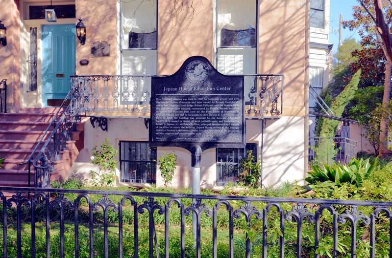
This Italianate mansion was built in 1856 for Savannah grocer and Civil War mayor Thomas Holcombe and later owned by former Confederate officer and Superior Court Judge Robert Falligant and his descendants. The Oglethorpe Light Infantry, commanded . . . — — Map (db m108969) HM
On Abercorn Street near Charlton Street, on the right when traveling south.
Site of
Marist School for Boys
1919 - 1939
——
Grammer School Operated by
Marist Brothers of the Schools
——
Last Graduating Class June 9, 1939
Rev. Bro. Eugene Bergeron, F.M.S.
Teacher
Rev. Bro, . . . — — Map (db m18424) HM
On East Gordon Street near Abercorn Street, on the right when traveling north.
Massie School is the only remaining building of Georgia's oldest chartered school system. Constructed in 1855-56 and opened for classes on October 15, 1856, the Greek Revival building is listed on the National Register of Historic Places. Peter . . . — — Map (db m5503) HM
Paula and Richard Rowe, along with May and Paul Poetter, founded the Savannah College
of Art and Design in 1978. In March 1979, the college purchased its first building, this former Savannah Volunteer Guards Armory, built in 1892. The college . . . — — Map (db m5770) HM
On West Bay Street (Georgia Route Conn 25) just east of Fell Street, on the right when traveling east.
The first schools in the West Savannah neighborhood were established on Fell Street south of this spot in the early twentieth century. The Saint Anthony of Padua school was one of three schools established by Father Ignatius F. Lissner and a group . . . — — Map (db m157196) HM
On West 36th Street, on the right when traveling west.
This was the site of the first hospital in Savannah to train African-American doctors and nurses. Named for Doctors Cornelius and Alice McKane, it began on June 1, 1896, when a small group of African Americans received a charter to operate the . . . — — Map (db m11703) HM
On East Henry Street at Java Place, on the left when traveling west on East Henry Street.
In 1906, eleven African-American men formed the Colored Library Association of Savannah and established the Library for Colored Citizens. They acquired the original collection from personal libraries and public donations of books and periodicals. In . . . — — Map (db m108955) HM
On Florance St near W 35th St, on the right when traveling west.
Florance Street School was designed by the firm Levy and Clarke and built in 1929 as one of the early public schools in Savannah built specifically for African-American students. It contributed greatly to Savannah’s Cuyler-Brownville community by . . . — — Map (db m12088) HM
Savannah High School evolved as the senior division of Chatham Academy, chartered by the Georgia Legislature in 1788. In 1935, due to overcrowding in schools, the Board of Education collaborated with the Public Works Administration to erect this . . . — — Map (db m9291) HM
On West 36th Street west of Martin Luther King Jr. Boulevard, on the left when traveling west.
On November 28, 1959, the residence of Dr. Calvin and Virginia Kiah at 505 W. 36th Street opened to the public as the Kiah Museum. The Kiah's were pioneers in the black cultural and museum movement and created the first African American-founded . . . — — Map (db m200260) HM
On Drayton Street at East Bolton Street, on the right when traveling north on Drayton Street.
A pioneer in women’s education, Nina Anderson Pape completed her studies at Columbia University. She founded the Froebel Circle, which educated the poor children of Savannah’s Yamacraw Village; and Tybee Island’s Fresh Air Home for disadvantaged . . . — — Map (db m8659) HM
On West Bay Street (Georgia Route 25 Conn) at Jenks Street, on the right when traveling east on West Bay Street.
Moses J. Jackson was the founder of the first public elementary school for African American students in West Savannah. He was a highly admired and respected community leader who championed many significant initiatives in the decades before and after . . . — — Map (db m157280) HM
On Broad Street (Georgia Route 520) 0 miles east of Clarke Duncan Highway (Georgia Route 137), on the left when traveling east.
On this site, a brick school building was erected in 1911 on land purchased from G. W. King, Sr. A resolution was passed on June 6, 1922 to consolidate Big Sandy, Liberty Hill, Renfroe, and Providence Schools with Cusseta. In 1929, all high schools . . . — — Map (db m38790) HM
On East Marietta Street, 0 miles north of Elizabeth Street, on the right when traveling north.
Born April 15, 1821 in Pickens District, South Carolina, he grew up in Union County, Georgia. He taught to pay for his education and while teaching in Canton he read law at night, being admitted to the bar in August, 1845. He graduated from the . . . — — Map (db m21891) HM
On Martha Berry Highway (U.S. 27) 0.5 miles south of Hartford Road (Georgia Route 37), on the left when traveling south.
Founded in the 1880’s Oakland High School’s name was derived from oak trees which grew in abundance at this location when the school building was constructed. The school originally had 10 grades. Mrs. Arlene Newton Richardson taught here from 1908 . . . — — Map (db m47764) HM
On Days Cross Road (County Route 2411) at Cottonhill Road, on the right when traveling east on Days Cross Road.
Here stood the Cotton Hill Male and Female Seminary incorporated by an Act of the Legislature March 6, 1856, but in existence before that time. Professor Norman Flavius Cooledge, uncle of President Calvin Coolidge, who had come to Georgia for the . . . — — Map (db m47103) HM
On Jefferson Street, 0 miles west of Jackson Street, on the right when traveling west. Reported missing.
In 1857, the Legislature authorized a lottery to complete this college, chartered in 1838 as Fort Gaines Female Institute. It was finished in 1859. Sereno Taylor was the first principal, followed by John W. Grant. The large college building was used . . . — — Map (db m164124) HM
On New Hope Church Road (County Route 129) 2.6 miles west of Georgia Route 39, on the right when traveling west.
New Lowell United Methodist Church
Methodist Episcopal Church worship services were conducted in this area during the early 1840’s in a brush arbor. The original church, known as Lowell, was destroyed by fire during the Civil War. From 1865 to . . . — — Map (db m23419) HM
On Floyd Road Southwest, 0.1 miles north of Maran Lane Southwest, on the right when traveling north.
In 1838, Robert and Pheriby Mable moved to this site and later purchased 300 acres of land from Denson Melton who had received it from the State of Georgia in a land lottery. They lived with their growing family in a two room cabin on the property. . . . — — Map (db m197627) HM
Sara Freeman Clarke established the first public library in Marietta and Cobb County in 1882 when she allowed residents to borrow books from her home without charge. She named it the “Franklin Lending Library”.
The next year, a group . . . — — Map (db m60577) HM
On South Park Square NE east of West Park Square NE, on the left when traveling east.
Created December 3, 1832, and named for Judge Thomas W. Cobb, a former U.S. Senator, Marietta was named for his wife.
Fertile lands gave impetus to farming; ample water power encouraged industries. People from further south sought Marietta as . . . — — Map (db m1660) HM
Near West Atlanta Street SE, 0.2 miles north of Cemetery Street SE.
Oldest grave is on this plot for Wm. Harris' son, William Capers G. Harris (1823-1831). Mr. Harris, a wealthy planter, was a devout Methodist and champion of education. In War of 1812 he served in Capt. Jett Thomas' Co., 2nd, Regt., Ga. Militia. He . . . — — Map (db m15202) HM
On Powder Springs Street SE (Georgia Route 360) at Hedges Street SE, on the right when traveling south on Powder Springs Street SE.
Opened in 1851 on a 110-acre campus, the Institute had a 4-year curriculum modeled after West Point. The cadet lifestyle was strict. Students attended classes all day followed by an hour-long drill, dress parades at sunset and evenings spent . . . — — Map (db m33698) HM
The Lemon Street Grammar School opened in 1894. The original wooden structure was funded by Marietta’s school board, and designed to educate Negro students. The high school was built nearby in 1930 at urging of Ursula Jenkins. Professor M. J. Woods . . . — — Map (db m60575) HM
On Kennesaw Avenue NW, 0 miles north of Stewart Avenue, on the right when traveling north.
This house was the residence of Alice McClellan Birney, co-founder of the National Congress of Parents and Teachers during the post-war era.
The home was probably built by Miss Mary Ann Nesbit prior to 1869, in which year it was purchased by . . . — — Map (db m19980) HM
Near West Atlanta Street SE, 0.1 miles north of Cemetery Street SE.
"The greatest friend Univ. of Ga. ever had" began his academic career in Marietta: principal, Supt. City Schools 1892-1903. At Georgia (1903-1945) promoted academics and sports: Faculty chrm. athletics from 1908; first head School of Journalism in . . . — — Map (db m17028) HM
On 2nd Avenue Southeast at 1st Street Southeast (Business U.S. 319), on the right when traveling west on 2nd Avenue Southeast.
This sundial was given to the Moultrie Chapter of the Colonial Dames of America in 1993 to commemorate the 100th year of the founding of The Colonial Dames of America in Georgia. The sundial is the oldest known device that is used to measure time. . . . — — Map (db m197799) HM
Near Scotts Ferry Road (U.S. 221) just north of Apple Lane, on the right when traveling north.
Dedicated in the honor of a gentleman, who was a true friend to all children of Columbia County; a youth league organizer, coach, sportsman, and community leader. Mr. Morris had vision for the establishment of this park and through his leadership . . . — — Map (db m246026) HM
On Cobbham Road (State Road 150), on the right when traveling west.
On this site stood the home of William Few, one of Georgia's signers of the United States Constitution. Built in 1781, the house burned in 1930.
William Few was born near Baltimore, Maryland, June 8, 1748. In 1776 he moved to Augusta, . . . — — Map (db m27053) HM
On U.S. 280 at Gannon Road, on the left when traveling west on U.S. 280.
This camp, as proposed by Cpl. J.M. Moore, Georgia State Highway Patrol, and sponsored by the Veterans of Foreign Wars, Emmett R. Culbreth and James H. Floyd, State Commanders; Department of Public Safety, George Wilson, Director, and the Department . . . — — Map (db m111394) HM
On Clay Pit Road, 0.1 miles south of Georgia Veterans Road, on the right when traveling south.
Here begins “Georgia Veterans Memorial State Park.” This 1,200 acre tract of land was purchased by Crisp County Commissioners and given to the State of Georgia December 4, 1946 in grateful appreciation of, and as a living memorial to the . . . — — Map (db m35041) HM
On Clay Pit Road, 0.1 miles south of Georgia Veterans Road, on the right when traveling south.
In 1952, the V.F.W. opened Camp Safety Patrol. Here, with the cooperation of the Department of Public Safety, over 72,000 youths camped and learned school safety practices. The V.F.W. made improvements, built facilities and obtained equipment for . . . — — Map (db m35042) HM
On South Church Street, 0.1 miles south of Miller Avenue, on the right when traveling south.
A male academy was established in Attapulgus in 1836 and a female academy in 1852. A four-room frame building was built on the site after establishment of public education in Georgia in 1872. In 1921 Mariola School joined Attapulgus and a frame . . . — — Map (db m40742) HM
On Martin Luther King Jr. Drive at South Boulevard Drive, on the right when traveling west on Martin Luther King Jr. Drive.
First Flint River Baptist Normal Institute
In 1876, the First Flint River Missionary Baptist Association was formed to help “lift the veil of ignorance from its people” using land purchased in 1896 and 1915. The Association . . . — — Map (db m40946) HM
On Martin Luther King Jr. Drive at Progress Street, on the right when traveling west on Martin Luther King Jr. Drive.
The first school for former slaves in this county was established in 1869 and was known as the Whittier School and Tabernacle for Colored Children. It was on Shotwell Street and had grades 1-7. The name soon changed to Whittier Normal School . . . — — Map (db m40945) HM
On Dothan Road (U.S. 84) at Cyrene Road, on the right when traveling west on Dothan Road.
Cyrene
Approximately 1.6 miles north of this location is the village of Cyrene. Founded about 1890 by C. S. Hodges and W. G. Powell, Cyrene was typical of the many mill towns established along the railroad to utilize the vast forests of . . . — — Map (db m55958) HM
On Peachtree Road (Georgia Route 141) at Lanier Drive, on the right when traveling south on Peachtree Road.
Chartered in 1835 by Georgia Presbyterians near Milledgeville, Oglethorpe University was the first denominational college established in the Deep South.
It perished during the Civil War and was briefly revived from 1870 to 1872 in Atlanta. . . . — — Map (db m14291) HM
On Ponce de Leon Avenue (U.S. 78) near Oakdale Road NE, on the right when traveling west.
Alpha Delta Pi Sorority was founded May 15, 1851 at Wesleyan College in Macon, Georgia, as the first secret society in the world for college women, and thus became the mother of the social sorority system. Wesleyan College was the first educational . . . — — Map (db m28962) HM
On "Ivy Street" drive on Marist Campus, 0.1 miles west of Ashford-Dunwoody Road, on the right when traveling west.
On June 3, 2005, the central road of this campus was formally named “Ivy Street,” in honor of the hallowed tradition associated with the original Marist
campus on Ivy Street in downtown Atlanta.
With 32 boys and five . . . — — Map (db m14203) HM
On West Trinity Place just west of Electric Avenue, on the right when traveling east.
The Beacon Community was the center of Decatur’s African American community until its demolition by the Urban Renewal programs of the mid-1960s. Bounded by N. McDonough Street on the east, W. Trinity Place on the north, Water Street on the west and . . . — — Map (db m29260) HM
On Covington Highway (U.S. 278) at Cove Lake Road, on the right when traveling east on Covington Highway.
Birthplace of Rebecca Ann Latimer (1835-1930), daughter of Chas. and Eleanor (Swift) Latimer, pioneer settles at this point on the Decatur-Covington road. Married in 1853 to Dr. William H. Felton, later Member of Congress and a trustee of the . . . — — Map (db m33831) HM
Near John B Gordon Drive, 0.1 miles east of Jefferson Davis Drive, on the right when traveling east.
From 1875 until 1915 children in the Klondike Community in southern DeKalb County attended Powell Academy on S. Goddard Rd. The one room school was capable of housing 25-30 students. It got its name from George Washington Powell, pioneer resident . . . — — Map (db m208680) HM
Near John B Gordon Drive, 0.1 miles east of Jefferson Davis Drive, on the right when traveling east.
The Powell Academy was built around 1875, when Ulysses S. Grant was president. It was one of about 100 small community schools located in DeKalb County and served students in the Klondike Community until they reached Grade 6. The money for these . . . — — Map (db m208677) HM
On College Street (U.S. 23) at Harrell Avenue, on the right when traveling east on College Street.
Eastman’s first public school, serving both elementary and high school students, opened on this site in 1898. A second building was added in 1904. In 1946, financed through individual and community contributions, the school was remodeled.
In . . . — — Map (db m57232) HM
Established in 1959, Vienna High and Industrial School was a consolidated school for African Americans during segregation. As part of Georgia's massive resistance to federally mandated school integration, politicians and school officials sought to . . . — — Map (db m127159) HM
On West 3rd Avenue near North Slappey Boulevard (Business U.S. 82), on the right when traveling west.
Governor George Busbee (1927-2004) and his family lived in this ranch style home (c.1956) from 1962 until 1983. Busbee launched his underdog campaign from this residence in 1974 to become Georgia’s 77th governor with the slogan, “Elect a . . . — — Map (db m117147) HM
Near Pine Avenue just west of North Washington Street, on the left when traveling west.
This tree was planted by British Royal Air Force Veterans who learned their flying skills in the U.S.A.A.F. Southeast Army Air Corps during 1941-1943. It symbolizes the esteem, affection, and enduring friendship forged by these airmen and the people . . . — — Map (db m186956) HM WM
On West Broad Avenue at North Washington Street, on the right when traveling west on West Broad Avenue.
C.B. King dreamed of becoming a lawyer. He had served in the United States Navy and graduated from Fisk University. Because there was no law school for Blacks in segregated Georgia, he earned a law degree from Case Western Reserve University Law . . . — — Map (db m117200) HM
Near College Drive, 0.4 miles south of East Oglethorpe Boulevard (Business U.S. 82), on the right when traveling south.
DedicationOn July 7, 1994, the waters of the Flint River breached the levee that protected the campus of Albany State University. By the time the river crested, the water had risen to a maximum depth of 14 feet and had damaged all of the . . . — — Map (db m186991) HM
On Columbia Hghway (Georgia Route 62) at Martin Road (County Route 25), on the right when traveling west on Columbia Hghway.
Formal education began in 1897 on land from J.C. Hudspeth and Mrs. Elizabeth Freeman. A petition in 1924 halted a new school at Waters Ford. In 1925 a spacious masonary school opened one mile west of this marker for students from Freeman, Hilton, . . . — — Map (db m56427) HM
On Still Road (County Route 15) at Zion Church Road (County Route 7), on the right when traveling east on Still Road.
The school was established prior to 1879 and consolidated with Hilton School in 1925. It served as a Free Will Baptist Bible School for young ministers from 1930-1942. Reverend T. B. Mellette was the instructor and Reverend K. V. Shutes was . . . — — Map (db m47219) HM
On Central Boulevard (Georgia Route 17) near Simmons Street, on the left when traveling north.
The Pilgrim Missionary Baptist Normal and Industrial Institute for Colored Students was established here in 1880 by the Pilgrim Missionary Baptist Association. The school was established, organized, funded and staffed by African Americans. The . . . — — Map (db m7965) HM
On Wallace Drive at Rawls Drive, on the right when traveling south on Wallace Drive.
Georgia Governor Herman Talmadge created the Minimum Foundation Program in 1949 as part of a statewide equalization effort to improve school buildings and yet maintain racial segregation. Completed in 1956, Springfield Central High School . . . — — Map (db m238216) HM
On Roger Shaw Street at South Main Street (U.S. 1), on the left when traveling north on Roger Shaw Street.
Member of the Georgia House of Representatives for 29 years and Speaker of that body for 11 years, longer than any other man. He was the 12th Georgian in History to lie in state at the Rotunda of the State Capitol in Atlanta, Georgia. The World . . . — — Map (db m20976) HM
On Old Chapel Lane, 0 miles east of West Lanier Avenue (Georgia Route 54), on the right when traveling east.
Today’s Flat Rock AME Church originated in 1854 as a place of worship for slaves on nearby Spears Plantation, and it is believed to be the oldest African-American congregation in Fayette County. Originally known as Rocky Mount, the church moved . . . — — Map (db m22973) HM
On West Lanier Avenue west of Glynn Street N, on the left when traveling west.
Dedicated To The Memory Of Grady L. Huddleston 1923-2001 Past Master: Fayetteville #711: 1958 Past Master: Tyrone #644: 1953 State House of Representatives: 1947-1960 Magistrate Judge: 1987-2000 — — Map (db m114296) HM
On Holly Grove Church Road, 0.2 miles east of Robinson Road, on the right when traveling east.
This church was organized in 1897 near the banks of Camp Creek in an unincorporated area of western Fayette County. Until the first sanctuary was constructed here on land and with building materials donated by Flem Arnall, services were held under a . . . — — Map (db m22971) HM
Near Everett Springs Road, 0.1 miles north of Floyd Springs Road.
Everett Springs Seminary, antecedent of the famous Martha Berry Schools, was chartered in 1889 in Floyd County. The school, which was in existence until 1908, was the first mountain school in Georgia which had boarding facilities for its students. . . . — — Map (db m31361) HM
On Broad Street at Love Street, on the right when traveling south on Broad Street.
Chesapeake & Ohio RR Route: Dalton, Rome, Anniston, with stops in Cave Spring & Spring Garden, AL 1850s to post-Civil War.
• Southern RR operated the Dalton-Anniston line from 1894 to 1970s.
• Local historical documents show lively health spa . . . — — Map (db m197523) HM
On School Circle at Alabama Street, on the right when traveling north on School Circle.
In 1833, a deaf man, John Jacobus Flournoy, of Jackson County, great grandson of Jacob Flournoy, a French Huguenot, urging education for the deaf, interested Governor Wilson Lumpkin and the Georgia Legislature in the educational movement. At first . . . — — Map (db m47908) HM
On Berry College Entrance Road, 0.1 miles west of Martha Berry Highway (U.S. 27), on the right when traveling west.
Starting with a Sunday School in a log cabin one mile south of here, Martha Berry founded a boarding school for rural boys in 1902 on 83 acres of land, adding a school for girls in 1909. From this humble beginning, Berry College grew and, during . . . — — Map (db m47471) HM
On Water Wheel Road, on the right when traveling north.
From the mill’s construction in 1930, students under the supervision of a miller used the Old Mill to produce corn meal and food stuffs for the Berry Schools. The Republic Mining and Manufacturing Company donated the iron hub, while students built . . . — — Map (db m9488) HM
On Veterans Memorial Parkway NE (Loop Georgia Route 1) at Martha Berry Highway (U.S. 27) on Veterans Memorial Parkway NE.
Martha Berry, founder of the Berry Schools, was born and lived here at “Oak Hill.” Daughter of Capt. Tom Berry, wealthy plantation owner, she devoted her life to providing educational opportunities for the children of her less fortunate . . . — — Map (db m31330) HM
Near Veterans Memorial Parkway NE (Loop Georgia Route 1) at Martha Berry Highway (U.S. 27).
This cabin, birthplace of The Berry Schools, (now Berry College and Berry Academy) was built as a playhouse for Martha Berry and her brothers and sisters shortly after the Civil War. Here, in the late 1800’s, three small boys from Lavendar Mountain . . . — — Map (db m88397) HM
On School Street west of Pilgrim Mill Road, on the left when traveling east.
Cumming School, erected in 1923 by J. W. Fleming and Jim Hughes to house students in grades 1 through 11, burned in 1927. The same contractors rebuilt the structure.
The school served all grades until 1955, when high school students . . . — — Map (db m55980) HM
On Spring Street, 0 miles south of West Main Street (U.S. 29), on the right when traveling south.
Site of the home of Rev. John Martin Turner, born September 12, 1891, and Mrs. Olivia Jackson Turner, born April 5, 1893, a teacher at Holmes College of the Bible. They were married July 7, 1920. The Turners were the first missionaries of the . . . — — Map (db m21527) HM
On Providence Church Road (Georgia Route 77) at Shoal Creek Road, on the right when traveling south on Providence Church Road.
Shoal Creek Consolidated School was created in 1924. Grades one through nine were taught in a new brick building completed in 1925. It replaced Thomasville, Old Shoal Creek, and Parkertown Schools. Additional pupils came from Viola and Rock . . . — — Map (db m45183) HM
On Georgia Route 106 at Red Hill School Road, on the left when traveling west on State Route 106.
In 1912, William Thomas Sosby donated 1.4 acres near this site for the Red Hill School. Originally for grades 1-6, the school added grades 7-9 in 1922. After consolidation in 1925, a new school building was constructed here on land donated by Sosby . . . — — Map (db m15156) HM
On 15th Street just west of Piedmont Road, on the left when traveling east.
Joseph Habersham Chapter, National Society Daughters of the American Revolution was organized February 12, 1900 at the Executive Mansion. Mrs. William Lawson Peel, first Regent and Mrs. Allen D. Candler, wife of the governor, were among the five . . . — — Map (db m30510) HM
On Atlanta Student Movement Boulevard at Chestnut Street NW, on the right when traveling west on Atlanta Student Movement Boulevard.
In March of 1960, students of the six colleges comprising the Atlanta
University Center, having decided to challenge the scourge of
segregation in public and private facilities of Atlanta, presented a
manifesto entitled “An Appeal for Human . . . — — Map (db m185984) HM
On Atlanta Student Movement Boulevard at Chestnut Street NW, on the right when traveling west on Atlanta Student Movement Boulevard.
In February 1960, here at the site of Yates and Milton Drugstore, three students
from Morehouse College - Lonnie King, Joseph Pierce, and Julian Bond-- began to
rally students from Atlanta's other historically black institutions-- . . . — — Map (db m185906) HM
On Atlanta Student Movement Boulevard at Chestnut Street NW, on the right when traveling west on Atlanta Student Movement Boulevard.
On this site stood Yates and Milton Drug Store, the first African American Business of its kind in Atlanta.
It was here that the Atlanta Student Movement
was planned on February 4, 1960.
Clark College Class of 1961
Dedicated during . . . — — Map (db m185924) HM
On Atlanta Student Movement Boulevard at Chestnut Street NW, on the right when traveling west on Atlanta Student Movement Boulevard.
In early February 1960, Morehouse College students Lonnie King,
Julian Bond, Joseph Pierce and other students met here at the site
of the former Yates & Milton Drug Store-an informal gathering place
for students of the Atlanta University Center. . . . — — Map (db m185926) HM
Near Chastain Park Avenue Northwest, 0.1 miles east of Elliott Galloway Way, on the left when traveling east.
formerly
Fulton County Almshouse
has been placed on the
National Register
of Historic Places
by the United States
Department of the Interior
Built in 1911 — — Map (db m197640) HM
On Campbellton Road (Georgia Route 166) at Union Road SW, on the right when traveling east on Campbellton Road.
Owl Rock Church was founded in 1828 by Richmond Barge and other members of the Mutual Rights faction that withdrew from the Mount Gilead Methodist Episcopal Church. The church is named for an eight foot natural rock closely resembling an owl which . . . — — Map (db m14161) HM
Established by Act of the General Assembly Oct. 13, 1885; site selected Oct. 20, 1886.
Administration Building erected, 1887.
First session, Oct. 7, 1888.
In July, August, 1864, this site was occupied by one of a series of forts connected . . . — — Map (db m15839) HM
On North Avenue Northwest at Techwood Drive Northwest, on the right when traveling west on North Avenue Northwest. Reported missing.
The Georgia School of Technology held its first classes
in the fall of 1888 in two towering buildings. One of them,
now known as Tech Tower, housed classes taught by
five professors. The other was a machine shop, fully
stocked with a foundry, . . . — — Map (db m227626) HM
Clement A. Evans, Brig. Gen., C.S.A., began his military career in his native Stewart Co., Ga., where he was commissioned Major in Co. E, 31st Ga. Infantry. He rapidly rose in rank and in Nov. 1864, was put in command of a division, succeeding . . . — — Map (db m64826) HM
On Auburn Avenue NE at Jesse Hill Jr. Drive NE, on the right when traveling west on Auburn Avenue NE.
Big Bethel served as Sweet Auburn's City Hall, the site of mass meetings to improve the lives of Atlanta's blacks in the first half of the 20th century. The church established the Gate City Colored School, the first public school for black students . . . — — Map (db m186416) HM
On Courtland Street NE at Baker Street NE, on the right when traveling south on Courtland Street NE.
On April 21, 1880, four Sisters of Mercy from Savannah, Georgia opened Atlanta's first permanent hospital, a 10-bed facility located on this site, where it remained for nearly 100 years.
During that time, the hospital grew in size and scope, . . . — — Map (db m106788) HM
On Peachtree Place NE, 0 miles west of Crescent Avenue NE, on the right when traveling east.
This site was known as the Cotting Estate in the mid 1800’s. David Cotting, teacher, editor and lawyer, served as Secretary of State from 1868-1873. He was also a member of the Constitutional Convention. Frances Cotting lived here after her . . . — — Map (db m109190) HM
On Auburn Avenue NE at Howell Street NE, on the right when traveling east on Auburn Avenue NE.
After working all day, blacks crowded into five rooms over a grocery store here to take courses at Sylvia Bryant's adult night school. Bryant Preparatory Institute had four teachers and a full enrollment of 175 students when it opened in 1910. . . . — — Map (db m186432) HM
On Auburn Avenue NE at Howell Street NE, on the right when traveling east on Auburn Avenue NE.
Charles Lincoln Harper, who lived here from 1891 to 1945, worked tirelessly as an educator and civic leader to overturn Atlanta's segregationist policies. As principal of Booker T. Washington High School, which Martin Luther King, Jr., attended, . . . — — Map (db m186433) HM
On Courtland Street NE at John Wesley Dobbs Avenue NE, on the right when traveling north on Courtland Street NE.
American Missionary Association (A.M.A.) teachers and clergy came to the post-Civil War South to help educate freed slaves. In 1866, missionaries established the Storrs School, located on Houston Street near Piedmont Avenue, to provide social, . . . — — Map (db m186404) HM
On Auburn Avenue NE at Hilliard Street NE, on the right when traveling east on Auburn Avenue NE.
A native of Indiana, Alice Dugged had an impressive educational experience: Wilberforce University, the University of Chicago, Howard University, Clark College, and Morris Brown College. In 1885 she married Jefferson Cary and the couple moved to . . . — — Map (db m186424) HM
On Auburn Avenue NE at Hilliard Street NE, on the right when traveling east on Auburn Avenue NE.
On this corner stood the Auburn Avenue Branch Carnegie Library for African-Americans, from 1923 to the 1950's.
Alice Dugged Carey, the first principal of Morris Brown University (now College), along with Dr. W.E.B. DuBois and others led the fight . . . — — Map (db m186423) HM
On Auburn Avenue NE at Hilliard Street NE, on the right when traveling east on Auburn Avenue NE. Reported missing.
On this corner stood the Auburn Avenue Branch Carnegie Library for African-Americans, from 1923 to the 1950s. Alic Dugged Carey, the first principal of Morris Brown University (now College), along with Dr. W.E.B. Dubois and others led the fight to . . . — — Map (db m127281) HM
On William Holmes Borders Sr. Drive at Gartrell Street, on the left when traveling north on William Holmes Borders Sr. Drive.
The National Congress of Colored parents and teachers grew from a meeting called at the request of Selena Sloan Butler through the school principal, Cora B. Finley, at Yonge Street School, March 14, 1911. As interest grew, other school units were . . . — — Map (db m55232) HM
On Harris Street south of Jefferson Avenue, on the right when traveling south.
On the westerly acres of this tract contributed by John T. Egan, the City of East Point established Russell High School. After consolidation into Fulton County's school system, the school in 1927 was greatly enlarged with open courts, stucco walls . . . — — Map (db m187124) HM
On Summit Road, 0.3 miles east of Freemanville Road, on the right when traveling east.
Near this location stood the Summit School, one of the earliest public schools in rural Milton County. In 1895, A.S. Cantrell and John Cowart donated one acre each to the Trustees of the Summit School to erect a public school house. In 1908, The . . . — — Map (db m118160) HM
On Mimosa Boulevard at Pratt Street, on the right when traveling south on Mimosa Boulevard.
Built for D.H. Bradley by noted Atlanta architect Neel Reid, a Roswell resident from 1917-1926. The home exhibits Reid’s sense of scale and proportion. A later occupant was Charles Newton, a teacher at Roswell High School for 28 years and the . . . — — Map (db m109193) HM
On Sloan Street at Mill Street, on the right when traveling east on Sloan Street.
Erected in 1839 for workers in the Roswell Cotton Mill, these apartments were the first built in the South and are believed to be the oldest in the United States. They served briefly as a hospital for wounded Federal soldiers in 1864. The Roswell . . . — — Map (db m21730) HM
On Georgia Route 52 at Entrance drive to Oakland Elementary School, on the right when traveling east on State Route 52.
The educational center for this section for years, Oakland Academy was established in 1867, following the War Between the States, by Nathan T. Tabor and John E. Robeson, first teacher. Originally a private school, it was operated for many years as a . . . — — Map (db m40577) HM
454 entries matched your criteria. Entries 101 through 200 are listed above. ⊲ Previous 100 — Next 100 ⊳