Coral Ridge Properties built the City's first real estate office in 1964 at the intersection of Route 441 and Wiles Road, just outside the City limits. This 30-by-20 foot single-room wooden structure displayed maps and plats of subdivisions, none of . . . — — Map (db m47421) HM
On Southwest 1st Avenue south of Southwest 2nd Street, on the right when traveling south.
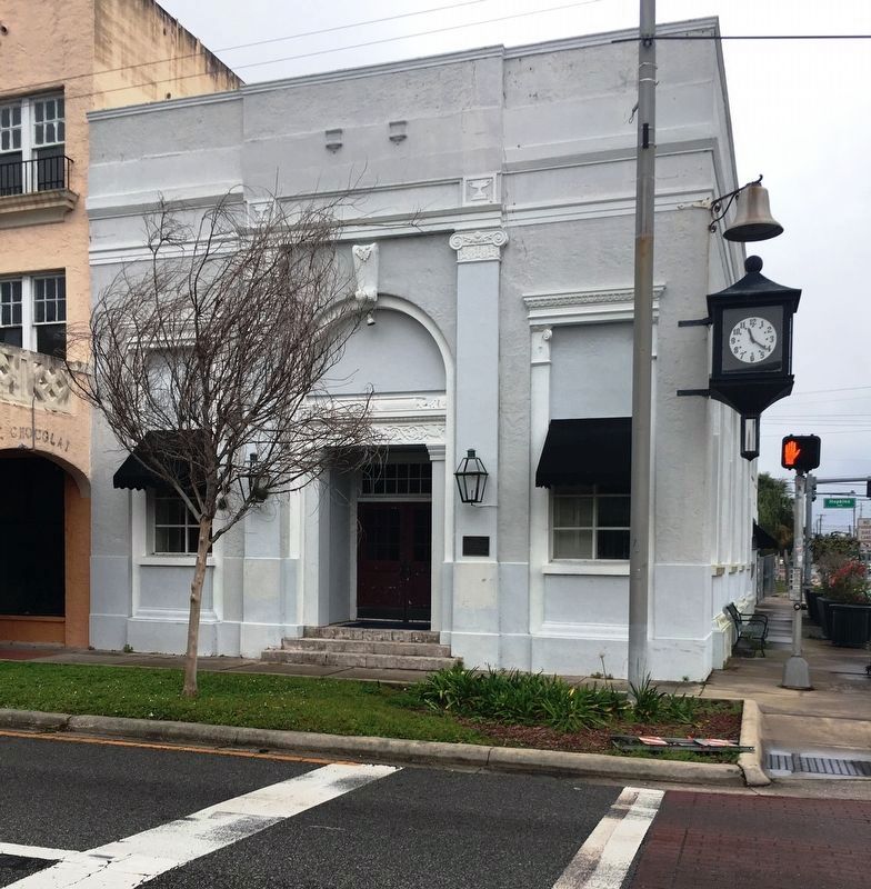
This building is one of only three remaining historical buildings on Brickell Avenue, the first commercial street of Ft. Lauderdale. Constructed as the Bivans Hotel in 1922, this building is the oldest surviving structure in Ft. Lauderdale built as . . . — — Map (db m100383) HM
On Southwest 2nd Avenue, 0.1 miles south of Southwest 2nd Street, on the right when traveling south.
In 1907, Edwin T. King, the town's first builder, a boatwright and an early citrus grower, built his third home on the south bank of the New River near what is now US 1. It remained the King family home until 1968. King's daughter Louise and her . . . — — Map (db m127492) HM
On Southwest 1st Avenue south of Southwest 2nd Street, on the right when traveling south.
One of three remaining historical buildings on Brickell Avenue, the first commercial street in the City of Fort Lauderdale, constructed between 1924 and 1926, the building was used primarily as a furniture store (as Pace Furniture then Rhodes . . . — — Map (db m100434) HM
On SW 2nd Avenue near SW 2nd Street when traveling south.
Old Fort Lauderdale Village at the intersection of the New River and the Florida East Coast Railway (F.E.C.) incorporates four turn-of-the-20th century historic buildings. These include the 1905 New River Inn, the 1905 Philemon N. Bryan House, the . . . — — Map (db m63880) HM
Near West Las Olas Boulevard east of Brickell Avenue/Southwest 1st Avenue, on the right when traveling east.
The façade is constructed in the same basic design configuration and from the actual bricks that existed on the west wall of the Oliver Building demolished in 1996. The original building was built in 1912 soon after most of Ft. Lauderdale's business . . . — — Map (db m100416) HM
On Southwest 2nd Avenue south of Southwest 2nd Street, on the right when traveling south.
Philemon and Lucy Bryan's home was built in 1905 by contractor Edwin T. King at the request of their two sons, Reed and Tom. Philemon and Lucy first lived in a wood-frame house that had been converted into the Bryan Hotel. The New River Inn replaced . . . — — Map (db m127489) HM
On Southwest 20th Street, 0.1 miles west of Southwest 15th Avenue, on the right when traveling west.
Honeymooning here in 1948, Frank and Gertrude Denison purchased the shipyard on this site known as Dooley's Boat Basin, renaming it Broward Marine. In 1950, they won the contract to build 11 minesweepers for the Dutch and U.S. navies. The seemingly . . . — — Map (db m216301) HM
On Florida Route 84, 0.3 miles east of Canal Drive.
Robert "Bob" Rosioli moved to South Florida from Philadelphia, Pennsylvania, with his family in 1956. He started working in the Florida marine industry in 1962, when he took a position sanding boats at the Marine Ways boatyard in Fort Lauderdale. In . . . — — Map (db m216303) HM
On Hollywood Boulevard (State Road 820) east of South 20th Avenue, on the right when traveling east.
Built in 1923 by Bastian Construction for professional offices, the building was occupied by Dentist Arthur Kellner, Hollywood's mayor in the 1930s, and Karlberg Studios Photographer. In the late 1990s to early 2000, the Hollywood Boulevard Theater . . . — — Map (db m99737) HM
On Hollywood Boulevard east of South 20th Avenue, on the right when traveling east.
The building was built by J.W. Young in 1925 as the new home for the Hollywood Land and Water Company's publishing business. The Toggery Shop Men's Wear was on the ground floor, east side. In 1934, James Breeding converted the building into a drug . . . — — Map (db m99738) HM
On Hollywood Boulevard (State Road 820) east of South 21st Avenue, on the right when traveling east.
Initially in other locations, Melina Tomich's shop sold children's wear. In 1946, Melina built the shop here at 2010 Hollywood Boulevard branching into ladies' wear, in particular lingerie. Today, Melina's is the oldest continually operated family . . . — — Map (db m99735) HM
On Hollywood Boulevard (State Road 820) east of South 20th Avenue, on the right when traveling east.
The Morse Arcade was built in 1923 by Mr. and Mrs. J.P. Morse, an arcade was an early mall with a variety of shops & offices. In 1927, it was the home of Hollywood's first library. — — Map (db m99790) HM
On Hollywood Boulevard (State Road 820) east of South 20th Avenue, on the right when traveling east.
Prohibition ended in 1933. In the mid-1930s, when gambling was legal on Hollywood Boulevard, Wellons & McGowan held a license for slot machines at this address. Shortly after that, it was acquired by Breeding's for a liquor store. — — Map (db m99788) HM
On Railroad Avenue at North Pear Street, on the right when traveling west on Railroad Avenue.
For 63 years (1909-1972) the Marianna and Blountstown Railroad was Calhoun County's link to the railroads and commerce of the nation. Sometimes known as "Many Bumps" or "Meat and Bread," the M&B had a significant impact on the lives of Calhoun . . . — — Map (db m167160) HM
On W Marion Ave at Taylor St, on the right when traveling west on W Marion Ave. Reported missing.
Hotel Punta Gorda, one the first buildings of any kind constructed in Punta Gorda, opened in January 1888 and served over 3300 guests within its first season. The three story building contained 150 rooms, all with a view of the waters of Charlotte . . . — — Map (db m216054) HM
On Tamiami Trail (U.S. 41) just north of West Marion Avenue, on the right when traveling south.
The Punta Gorda Bank was operating by June 1894 as a branch of the State Bank of Fort Meade. It was chartered by the state as a separate bank in July 1899, with a capital of $15,000 and Perry Wadsworth McAdow as president. McAdow had earned a . . . — — Map (db m167301) HM
Near North Suncoast Boulevard (U.S. 19) 0.3 miles north of West Cornflower Drive, on the right when traveling north.
A Man-made Lake Felburn Park was once a mine. Workers mined dolomite rock, which was added to soil on farms. As they dug, miners hit a reservoir of groundwater, and the spring water started to fill the pit. They pumped out the water as it . . . — — Map (db m167344) HM
On Northesat 3rd Street, 0.1 miles west of North Citrus Avenue.
Edwin and Mary King moved to Crystal River in 1863. They built a home nearby on the bay which came to bear their name. In 1879, a canal on the north side of the property was dug so that smaller boats could unload supplies from larger ships at the . . . — — Map (db m237202) HM
On Withlacoochee Bay Trail, 4.6 miles west of North Suncoast Boulevard (U.S. 19).
The Price of Progress Picture massive barges, tugboats and trawlers clogging the bay. This was to be the west end of the Cross Florida Barge Canal, where the water enters the Gulf of Mexico. The canal would have impacted Florida's fresh and . . . — — Map (db m167343) HM
Near West Withlacoochee Trail (County Road 39) just east of North Florida Avenue (U.S. 41), on the left when traveling east.
A Rocky Past Today, the old railroad bed beneath the Dunnellon Trail carries walkers and bicyclists. In the late 1800s, it moved train cars laden with phosphate rock. Prospectors discovered the valuable mineral here in 1889, sparking an . . . — — Map (db m167502) HM
On East Orange Avenue (County Road 48) at South Aroostook Way, on the left when traveling west on East Orange Avenue.
(Side 1)
The area containing present day Floral City has been inhabited by
humans for thousands of years. When Hernando De Soto came through
the area in 1539, he found the Indian village of Tocaste. From the late
1700s until the Second . . . — — Map (db m104967) HM
On West Yulee Dr, 0.1 miles north of West Bresler Court, on the right when traveling north.
David Levy Yulee (1810-1886), who built Florida’s first cross-state railroad, was the State’s first U.S. Senator. He came to Florida as an immigrant and rose to become an outstanding businessman and statesman. He served in Florida’s territorial . . . — — Map (db m237298) HM
On West Yulee Drive, 0.1 miles north of West Bresler Court, on the right when traveling south.
The juice flowed from the settling vats into the “grande,” the largest of five kettles built into the furnace below. The “grande” was also the coolest, being farthest from the “batterie” kettle under which the furnace was fired. The chimney draft . . . — — Map (db m237432) HM
Near West Yulee Drive, 0.1 miles north of West Bresler Court, on the right when traveling south.
The steam powered machinery which removed the juice from the cane was located here.
The fresh-cut cane was mashed between large, rotating iron cylinders and the juice was collected in vats. The crushed cane, called “bagasse,” was piled and . . . — — Map (db m175844) HM
Near West Yulee Drive, 0.1 miles north of West Bresler Court, on the right when traveling south.
The steam powered machinery which removed the juice from the cane was located here.
The fresh-cut cane was mashed between large, rotating iron cylinders and the juice was collected in vats. The crushed cane, called “bagasse,” was piled and . . . — — Map (db m175846) HM
On North Pine Avenue, 0.1 miles north of West Main Street (U.S. 41), on the right when traveling north.
This building, built in 1912, as the George Dickenson Grocery Store owned by Frank & George Dickenson, was constructed of red clay brick laid 12” thick and tied together with 1” iron rods to hold the 2nd story in place, with wood burning . . . — — Map (db m117169) HM
On Courthouse Square north of Old Main Street, on the left when traveling north.
Reportedly, this land was purchased by W.S. Warnock, founder of the Citrus County Chronicle and George Demuro, Clerk of the Court, in 1908. The building was constructed and operated by City Savings Bank in 1910. Edward Sasser ran a dry goods store . . . — — Map (db m122701) HM
On West Main Street at North Pine Avenue, on the left when traveling east on West Main Street.
”The Citizen's Bank” built this structure around 1912 and failed in the late 20’s. It was later occupied as: Vann's Drug Store, Bacon's Drug Store, Lanier's Drug Store, Culpepper's Drug Store, Bennett's Drug Store, Marshall's Drug . . . — — Map (db m125473) HM
On North Apopka Avenue north of Courthouse Square, on the right when traveling north.
The All-American drink was introduced to Citrus County in the early 1900's. W.T. Baxley acted as a sub-bottler to the Tampa Coca Cola Bottling Company, and began bottling it in Hernando in 1906. Empty bottles were washed in Hernando Lake, then . . . — — Map (db m117170) HM
On West Main Street (Old Main Street) east of North Pine Avenue, on the right when traveling east.
The Masonic Temple for Citrus Lodge #118, F. and A.M., was built on Main Street and dedicated in 1910, ready for occupancy in January, 1911. A splendid three-story brick building costing $17,285, the most costly building in the county. Originally . . . — — Map (db m122748) HM
On West Main Street (Gulf to Lake Highway) (State Road 44) west of North Osceola Avenue, on the right when traveling west.
This two story wood frame Colonial Revival style residence features a beautiful verandah best suited for socializing on warm summer evenings was built in 1903, by James Keels Kelley. According to a 1936 Citrus County Chronicle article, J.K. Kelley . . . — — Map (db m126053) HM
On Tompkins Street at North Osceola Avenue, on the right when traveling east on Tompkins Street.
According to the old family bible, Robert Orval and Emma (Demoss) Hicks, Tennessee farmers, married in 1888 and established a successful steam boat business, carrying fruit and vegetables down the Withlacoochee River just east of Inverness. A freeze . . . — — Map (db m126038) HM
On West Main Street at North Pine Avenue, on the right when traveling west on West Main Street.
The current Bank of Inverness building was erected on Main Street in 1916 and housed the Citrus County Bank which closed in January 1929. By June of 1929 the only remaining bank in Citrus County was the Bank of Homosassa. On November 20, 1929, the . . . — — Map (db m126084) HM
On Courthouse Square north of Old Main Street, on the left when traveling north.
This building was built by Francis Marion Dampier, Jr. as Dampier Department Store.
The family operated the successful department store from 1945 to 1967. It is remembered that "Frank" Dampier spent many hours sitting on a wooden bench under an . . . — — Map (db m117177) HM
On Old Main Street east of North Pine Avenue, on the left when traveling east.
This building, best remembered as Allen’s 5, 10 & 25 Store, was built by Jack Kibler in the early 1920’s. Occupants included the Inverness Post Office, Vann’s Drug Store and Ernest Johnston’s Restaurant prior to Allen’s 5, 10 & 25 opening in 1932. . . . — — Map (db m125464) HM
On West Main Street (Gulf to Lake Highway) (State Road 44) at South Seminole Avenue, on the right when traveling east on West Main Street (Gulf to Lake Highway).
This house was built in 1903 for George Carter, Citrus County's third sheriff. The Carter House was the first house in Inverness to have a bathroom and was one of the first 13 buildings in Inverness to be “wired up” when electricity came . . . — — Map (db m126060) HM
On North Apopka Avenue, 0.1 miles north of West Dampier Street, on the right when traveling south.
Built around 1915, this house is most remembered for the McLeod family who lived here from 1941 to 1998. Oscar Penn McLeod was born to a pioneer family near Perry, Florida. He was awarded a teaching certificate in 1918 and married Mayo Artie . . . — — Map (db m117128) HM
On Courthouse Square, 0.1 miles north of West Main Street (U.S. 41), on the right when traveling north.
Mrs. Pearl G. Maddox built the theatre in 1926-27 during the silent movie era, naming it the Valerie after her daughter. The first movie shown was “The Only Woman” in 1927; the last was “The Untouchables” in 1987. Herbert . . . — — Map (db m117178) HM
On South Magnolia Avenue at Spring Street, on the left when traveling north on South Magnolia Avenue.
Originally from Indiana, Dr. Joseph W. Applegate moved to Florida after the Civil War to work with the Freedmen's Bureau at Magnolia Springs. He later partnered with John H. Harris to operate the Clarendon Hotel (c. 1871) in Green Cove Springs. By . . . — — Map (db m135555) HM
On Walnut Street near St Johns Avenue, on the right when traveling east.
High ground along the river and a flowing mineral spring drew the first inhabitants to this area some 7000 years ago, but historic development dates from 1816 when George I. F. Clarke erected a sawmill in this vicinity under a Spanish land grant. . . . — — Map (db m63712) HM
On Main Street at Wharf Street, on the right when traveling east on Main Street.
Samuel B. Thompson owned and operated
dock and warehouses at the foot of
Thompson St. (now Wharf St., name changed
about 1951). Thompson's warehouses were
burned by Union soldiers in 1864.
After the Civil War, Albert S. Chalker
operated . . . — — Map (db m70285) HM
On Kingsley Avenue at Park Avenue (Route 17), on the right when traveling west on Kingsley Avenue.
Orange Park was the site of a cotton and citrus British plantation, Laurel Grove, which was established by William and Rebecca Pengree during Florida’s British Period (1763-1783). Following the American Revolution, Florida was returned to . . . — — Map (db m102603) HM
On Hibiscus Street West north of West Broadway Avenue, on the right when traveling west.
This site was the home of William Smith Allen who settled here in the 1870s. He sold the property to George Storter, Jr., in 1889 and it was expanded to include a Post Office, trading post, and warehouses for the thriving sugar cane syrup trade. . . . — — Map (db m190547) HM
On 12th Avenue South at 8th Street South, in the median on 12th Avenue South.
This "Back Bay" area was settled in 1915. As Naples' first sheltered mooring, it became the community center for the pioneers building the Tamiami Trail as well as the fishing industry. The first pharmacy, the first newspaper, and all the important . . . — — Map (db m127760) HM
Near 12th Avenue South west of Gulf Shore Boulevard South when traveling west.
Built in 1888 as a freight and passenger dock, the Naples Pier stands as a community landmark. Narrow gauge train rails spanning the length of the pier transported freight and baggage in the early 1900’s. Part of the structure as well as the post . . . — — Map (db m92802) HM
Near Rookery Lane north of Sanctuary Road West, on the left when traveling north.
”We have to save the swamp a hundred times but we only get to lose it once.” In the 1930’s lumbermen began logging bald cypress trees because the trunks were knot-free and the wood was highly resistant to rot. Lumber . . . — — Map (db m164799) HM
Near Unnamed trail west of Tamiami Trail East (Florida Route 41), on the right when traveling west.
The first highway from Tampa to Miami, called the Tamiami Trail, was built in the 1920's. The "walking dredge” was a piece of specialized equipment used to dig a canal, which provided
rock fill for the roadbed and drainage for the completed road. . . . — — Map (db m194927) HM
Near 12th Street South at 6th Avenue South, on the left when traveling south.
Tin City's legacy began in the 1920's when Henry Espenlaub, brother-in-law of Ed Frank (Swamp Buggy Creator), leased his property to pioneering commercial fishing families. They constructed docks and tin roofed buildings to serve fishing fleets and . . . — — Map (db m90088) HM
On Tamiami Trail East (U.S. 41) 0.2 miles west of Bass Lake Road, on the left when traveling west.
Considered to be the smallest post office in the United States, this building was formerly an irrigation pipe shed belonging to the J. T. Gaunt Company tomato farm. It was hurriedly pressed into service by postmaster Sidney Brown after a disastrous . . . — — Map (db m90091) HM
On Northwest Falling Creek Road (County Road 131) 0.9 miles north of US Highway 41 (State Road 100), on the right when traveling north.
Falling Creek Falls Park is a cooperative venture between the Suwannee River Water Management District (SRWMD) and the Columbia County Board of County Commissioners. The SRWMD acquired the land through the Preservation 2000 land acquisition program . . . — — Map (db m126089) HM
On North Monroe Avenue at West Hickory Street (State Road 70), on the right when traveling north on North Monroe Avenue.
The Town of Arcadia was settled in 1883, incorporated in 1886, and became the county seat in 1888. By the late 1880s the population was 300. On Thanksgiving night 1905 the town burned. Three brick stores survived. Using only brick or block, . . . — — Map (db m72535) HM
On Southwest Highway 17 (U.S. 17) south of Cowart Street, on the right when traveling north.
(obverse)
The town of Nocatee originated as a lumber manufacturing town during the 1880s. During the late 19th century. two businesses stimulated the town's growth. One was the King Lumber and Manufacturing Company, established by W.G. . . . — — Map (db m211953) HM
On U.S. 19, 0.1 miles west of Northeast 223rd Avenue (County Road 351A), on the right when traveling north.
Putnam Lodge, built in 1927-28 by the Putnam Lumber Company, is part of a bygone era in Florida's forestry history. Here, beside the old Dixie Highway, Putnam Lodge, part of the "company town" of Shamrock, accommodated tourists, transients and . . . — — Map (db m77791) HM
On Center Street South at Drew Street West, on the right when traveling north on Center Street South.
The Coleman House was built in 1879 and purchased by William Coleman in 1881. The house served as a family home to the Coleman and Clark families until purchased by the town in 2000. Through the years the Coleman House served as a boarding house for . . . — — Map (db m239242) HM
On Fort George Road, on the right when traveling north.
(Upper left plaque)
National Register Site
Ribault Club Inn
1928
Awarded By
Jacksonville Historic
Preservation Commission
(Lower left Plaque)
Ribault Club Inn
Has Been Placed On The
National . . . — — Map (db m58614) HM
On Arlington Road at Marcheck Street, on the left when traveling west on Arlington Road. Reported missing.
On the morning of May 17, 1888, residents in the wooded communities of Old Arlington woke up to the new sounds of a chugging steam engine and the rattle of railroad cars. It was on that day the Jacksonville, Mayport and Pablo Railroad and . . . — — Map (db m173407) HM
Near Palmetto Avenue, 2.1 miles north of Fort George Road when traveling north.
After the Civil War, slavery ended, but former slaves continued to live on the island. In this new era, former slaves and new landowners had to make difficult choices.
In 1869 the Rollins family settled at the former plantation and called it . . . — — Map (db m145390) HM
On Heckscher Drive (State Road A1A) south of Fort George Road, on the left when traveling south.
(side 1)
Pilot Town
The St. Johns River provided trade access that supported the economy of the Fort George Island plantations. Cotton and sugar from the plantations were transported on the river to trading posts. Early Spanish . . . — — Map (db m106389) HM
Near Palmetto Avenue, 2.2 miles north of Fort George Road when traveling north.
English:
Once the Portuguese made successful transatlantic trading voyages, other European nations quickly followed. In the eighteenth century, the port of Nantes became the busiest French port involved in the European slave trade . . . — — Map (db m145391) HM
Near Palmetto Avenue, 2.2 miles north of Fort George Road when traveling north.
English:
Slavery has been a component of human history through time. Whether captured, purchased, or taken as spoils of war, enslaved people had wide-ranging experiences, but they all shared one thing in common: loss of freedom. . . . — — Map (db m145392) HM
Near Palmetto Avenue, 2.1 miles north of Fort George Road when traveling north.
Where there is now a tranquil river scene, a dock hustled and bustled with activity during the plantation era. Cotton bales were sent to market, and slaves and finished goods were brought here by boat.
Most plantations were located along . . . — — Map (db m145388) HM
On Mandarin Road at County Dock Road, on the left when traveling north on Mandarin Road.
This barn, constructed in 1876 for Major William Webb, was most likely built from re-used lumber. It was used for storing farming implements and produce to be shipped. The barn was restored in 1999 with the assistance of a grant from the State of . . . — — Map (db m171584) HM
On Mandarin Road at Brady Road, on the left when traveling south on Mandarin Road.
Mandarin Store and Post Office
has been placed on the
National Register of Historic Places
by the United States Department of the Interior — — Map (db m171512) HM
On Mandarin Road at County Dock Road, on the left when traveling north on Mandarin Road.
Mandarin depended heavily on the timber business and many sawmills dotted the shorelines in the late 1800s. This old sawmill was found along the banks of Oldfield and Julington Creeks and is believed to be part of the Wheeler Sawmill from the . . . — — Map (db m171582) HM
On Arlington Road, 0.1 miles west of River Bluff Road North, on the right when traveling west.
Ferry service from Jacksonville and Arlington began in 1914 and was Sponsored by the Alderman Company. The service gave access to 1,100 acres of plantation land bought and subdivided by the company in 1913 and provided the impetus for growth and . . . — — Map (db m173403) HM
On Moncrief Road near Edgewood Avenue, on the right when traveling west.
Pioneer Abraham Lincoln Lewis (1865-1947) and others founded Florida’s oldest African-American insurance company, Afro-American Life in 1901, which spread throughout the South as far as Texas. In 1926, A.L. Lewis opened Lincoln Golf and Country Club . . . — — Map (db m58382) HM
Near San Jose Boulevard (State Road 13) at St Augustine Road, on the right when traveling west.
San Jose Estates
Administration Building
Built 1925
has been placed on the
National Register
of Historic Places
by the United States
Department of the Interior — — Map (db m138035) HM
National Register Site The Village Store 1923 Marsh & Saxelbye, Architects Awarded by Jacksonville Historic Preservation Commission — — Map (db m239842) HM
On East 1st Street east of North Main Street, on the left when traveling east.
Constructed in 1901, the Barnett Mansion was the home of William D. Barnett, son of William D. Barnett, founder of the Bank of Jacksonville. The architect for the home was Leon Beaver of Knoxville, Tennessee. The building remains relatively . . . — — Map (db m239801) HM
On E Union Street near Ocean Street, on the right when traveling west.
The Afro-American Insurance Company, formerly the Afro-American Industrial and Benefits Association, was founded in 1901 to provide affordable health insurance and death benefits to the state's African-Americans. Founded by the Reverend E.J. Gregg, . . . — — Map (db m59633) HM
On North Laura Street at Forsyth Street, on the right when traveling north on North Laura Street.
Historic Landmark
Jacksonville National
Bank - 1902
Edward H. Glidden, Architect
Awarded by
Jacksonville Historic
Landmarks Commission — — Map (db m220891) HM
On West DuVal Street near N Hogan Street, on the left when traveling west.
On May 3, 1901 at 12:30 p.m., a fire began at the Cleaveland Fibre Factory, ten blocks northwest of this site. Chimney embers ignited sun-dried moss to be used as mattress stuffing. Fueled by wind and dry weather, the fire roared east destroying . . . — — Map (db m58013) HM
Near West Bay Street west of Park Street, on the left when traveling west.
United States Railroad Administration Locomotive
Atlantic Coast Line Class P-5-A 4-6-2 No. 1504
1919
During the World-War I emergency, American Railroads were placed under the control of the United States Railroad Administration (USRA) . . . — — Map (db m152610) HM
Near West Bay Street near Park Street, on the left when traveling west. Reported missing.
National Historic
Mechanical Engineering Landmark
United States Railroad Administration Locomotive
Atlantic Coast Line Class P-5a 4-6-2 No. 1504 1919
During the World-War I emergency, American railroads were placed under the control . . . — — Map (db m59100) HM
The Mayport Depot was built in 1900 for the Florida East Coast Railway when Henry Flagler expanded the line running up to Mayport from a narrow gauge track to a standard gauge track. The new standard gauge line also provided transport for people . . . — — Map (db m107837) HM
On Front Street at Jefferson Avenue, on the right when traveling east on Front Street. Reported missing.
In 1901, one of the largest and most advanced southern pine sawmills east of the Mississippi River was built here. In the tradition of the era, the Alger-Sullivan Lumber Company built its own town to house and supply the families of mill workers. By . . . — — Map (db m120557) HM
On Century Blvd (U.S. 29) north of Hecker Rd, on the right when traveling north.
Century, Florida Founded in 1900 to house mill employees of the Alger-Sullivan Lumber Company, formed in 1900 by General Russell A. Alger - Governor of Michigan, U.S. Senator, and President McKinley's Secretary of War - and by Martin H. . . . — — Map (db m102557) HM
On South Devilliers Street, 0.1 miles south of West Main Street, on the right when traveling south.
Pensacola became a center for commercial fishing by the 1870s. The industry's primary export was red snapper (Lutjanus campechanus). Pensacola's fish houses, including E.E. Saunders & Co. on the Palafox Street wharf and the Warren Fish . . . — — Map (db m130815) HM
On South Palafox Street at West Main Street, on the right when traveling south on South Palafox Street.
Today's 407 South Palafox was built in 1898 as a brick building that encompassed 409 and 411 in one structure. It replaced an original wooden building erected by Henry Pfeifer in 1885. The building has served as a fruit and grocery, a tailor shop, a . . . — — Map (db m176969) HM
On East Main Street at South Jefferson Street when traveling east on East Main Street.
The success of the American Revolution spurred population growth and movement in the early 19th century. While many Americans moved west to claim new land, some looked south to Spanish West Florida. The flood of new settlers and increased pressure . . . — — Map (db m130794) HM
Near North Alcaniz Street near W.D. Childers Plaza.
Daniel F. Sullivan and his brother Martin, born in Ireland, arrived in Pensacola after the Civil War. Possessing a remarkable talent for business, the brothers purchased lumber mills and wharfs on Pensacola Bay and vast areas of timberland in . . . — — Map (db m80038) HM
On East Gonzalez Street at North Hayne Street, on the right when traveling east on East Gonzalez Street.
Originally the site of a dry goods store owned by Tierce Lee, a wealthy
black businessman listed in the Dunn and Bradstreet reports, and his
brother Shef, the building was bought by their brother Hamp and his
wife Ola in 1944 and converted to the . . . — — Map (db m177072) HM
On South 10th Avenue, 0.1 miles north of East Colfax Street, on the right when traveling north.
(Side 1)
The Hawkshaw site has supported prehistoric and historic occupations which span a period of nearly 2,000 years. It was inhabited around A.D. 150 by groups of Native Americans whom archaeologists call the Deptford Culture. Scientific . . . — — Map (db m72238) HM
On East Jordan Street at North Davis Street (Florida Route 291), on the right when traveling east on East Jordan Street.
The Historic Crystal Icehouse is a slice of early twentieth century life,
frozen in time. Built in 1932, the icehouse has been an Eastside
Neighborhood icon for many years. It was an integral part of
neighborhood life during the years before . . . — — Map (db m177056) HM
On Scenic Highway (U.S. 90) at Langley Avenue, on the right when traveling north on Scenic Highway.
The Chimney is the only trace of what once was the first major industrial belt on the Gulf Coast, a string of antebellum wood mills and brick factories. The chimney represents the lumber industry of the Florida Panhandle. As the lumber industry . . . — — Map (db m72244) HM
On South Palafox Street at East Main Street, on the left when traveling south on South Palafox Street.
Although the American Civil War (1861-1865) hindered much of Pensacola's early industrial growth, the city rebounded quickly once the war ended. Entrepreneurs from the northern United States saw great value in the area's deep port and natural . . . — — Map (db m130716) HM
A native of Aberdeen, Scotland, John Innerarity was the nephew of Spanish Pensacola's leading merchant William Panton. He arrived in Pensacola in 1802 to become managing clerk of the Panton, Leslie and Co. trading post. However, his uncle had died . . . — — Map (db m80078) HM
On East Gonzalez Street east of Dr Martin Luther King Jr Drive, on the right when traveling east.
This site was once the location of the office of Dr. John Lee Pickens.
Dr. Pickens, who came to Pensacola from Alabama, was considered
an asset to the city and to the Eastside neighborhood-- a diversified
neighborhood in terms of residents and . . . — — Map (db m177074) HM
On East Strong Street at North Hayne Street, on the left when traveling east on East Strong Street.
Born in 1838, John Sunday, a wealthy free man of color owned large
tracts of land and many houses in Pensacola including several properties
in the Eastside Neighborhood area. Mr. Sunday served as a Civil War
soldier who became a member of the . . . — — Map (db m177069) HM
Near North Alcaniz Street near W.D. Childers Plaza.
Born a nobleman in Spain about 1757, Noriega served his country with distinction in the Louisiana Infantry Regiment against the British at Baton Rouge, Mobile, and Pensacola between 1779 and 1781. His son Jose Noriega, born at Pensacola in 1788, . . . — — Map (db m80047) HM
On South Barracks Street at East Main Street, on the left when traveling south on South Barracks Street.
Mooring anchors like this one were lowered into Pensacola Bay during the 1800s. A pair of buoyed mooring anchors connected by a long, heavy chain gave sailing ships a place to moor (tie up) while waiting to enter Pensacola's harbor to load or unload . . . — — Map (db m91136) HM
On South Barracks Street at East Main Street, on the left when traveling south on South Barracks Street.
During the mid-1800s, 16 wharves reached into Pensacola Bay, along a three-mile stretch of waterfront from Bayou Texar to Bayou Chico. A few years later, around 1900, railroad companies invested in Pensacola's port facilities, improving wharves and . . . — — Map (db m91137) HM
On South Barracks Street south of Main Street (Florida Route 196), on the right when traveling south.
This inlet, known as Pitt Slip, was once the site of the B. R. Pitt
planing mill. Benjamin Rafford Pitt arrived in Pensacola in 1866 and
established a mill that manufactured doors, sashes, blinds, and other
building materials. The business later . . . — — Map (db m177101) HM
On South Spring Street at Main Street, on the right when traveling north on South Spring Street.
Indian trading post
established during the English occupation
1763-1783
and burial place of
Alexander McGillivray.
Born Ft. Toulouse, Ala. 1746
Died Pensacola, Fla. 1793
Made Chief of Creek Nation 1776
Commissioned British . . . — — Map (db m170763) HM
On North Palafox Street at West Garden Street (Business U.S. 98), on the right when traveling south on North Palafox Street.
(Side 1)
Site of the First Methodist Church of Pensacola
Pensacola's first Methodist congregation was established in 1821 by Alexander Talley, M.D. It met in a series of small, wood frame churches until 1881, when construction of a . . . — — Map (db m72235) HM
On South Jefferson Street at East Zarragossa Street, on the left when traveling south on South Jefferson Street. Reported permanently removed.
The Early Life of T. T. Wentworth, Jr.
Theodore Thomas Wentworth Jr. was born July 26, 1898, in Mobile, Alabama, to Elizabeth Goodloe and T. T. Wentworth, Sr. In 1900, the Wentworth family moved to Pensacola.
Young Tom helped . . . — — Map (db m91123) HM
900 entries matched your criteria. Entries 101 through 200 are listed above. ⊲ Previous 100 — Next 100 ⊳