Prospectors panned for gold in the Yankee Fork-Salmon River area from the late 1860's to 1879.
Then in 1880 the Yankee Fork Consolidated Gravel Mining Company built a ditch to bring water here for their new hydraulic gold mining operations. . . . — — Map (db m110013) HM
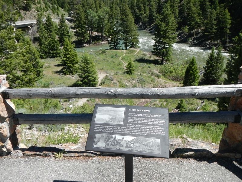
The Sunbeam Dam was constructed by the Sunbeam Consolidated Gold Mines Company to provide power for their mill located 13 miles up Yankee Fork on Jordan Creek.
Construction of the dam and power plant began in June, 1909, and was completed . . . — — Map (db m110010) HM
After the golden spike was driven at Promontory Utah in 1869 the nearest railroad station to Boise was Kelton on the north shore of the Great Salt Lake. A ferry was built 1/2 mile up on the river as a joint effort by Gustavus Glenn, a local rancher . . . — — Map (db m31678) HM
More than a century ago, Rocky Bar, Happy Camp, and a number of other South Boise mining towns flourished in a remote mountain wilderness 30 miles northwest of here.
Discovered early in 1863, they were so hard to get to that the could not be . . . — — Map (db m110142) HM
August the 13th "...the road to day way level but very rocky A long chain of mountains on our right and we travel close to them to day..." -- Absolom B. Harden, 1847
After the transcontinental railroad was completed in 1869, . . . — — Map (db m125755) HM
This building is an example of the stone craftsmanship of the Mormon pioneers of southeastern Idaho. Built in 1868 of local stone cut with a rough , or rusticated, finish, the building demonstrates the gradual change in the late 19th century from . . . — — Map (db m44454) HM
Official outlet of the ZCMI (Zion's Co-operative Mercantile Institution), "America's First Department Store". This building housed the Franklin Co-op from circa 1877 to 1900. It was part of the ZCMI co-operative system serving more than 150 . . . — — Map (db m105563) HM
President Brigham Young directed Mariner W. Merrill to explore new town sites. Out of Merrill's survey, several families from Richmond, Utah crossed the Bear River on April 15, 1865, and settled in the Weston area. The first dugouts were constructed . . . — — Map (db m140136) HM
Holding a unique niche in Idaho’s history, Big Falls Inn was built around 1915 by the Snake River Electric Light and Power Company. Although it may originally have been constructed as a combination office and residence for workers, it eventually . . . — — Map (db m73321) HM
Two panels make up this marker:
Island Park describes the northern part of Fremont County from the top of the Ashton Hill to the Montana border. Within its borders is an ancient volcanic caldera that has been inactive for the last . . . — — Map (db m109006) HM
In 1868, Gilman Sawtell started a dude ranch and Henry's Lake fishery that did much to develop this natural resort area.
Sawtell did everything from supplying swans for New York's Central Park zoo to building a network of roads for tourists . . . — — Map (db m108978) HM
In 1810, Andrew Henry and a party of trappers from Saint Louis established a winter outpost about 6 miles west of here.
Driven from their upper Missouri beaver camp by hostile Blackfeet, they expanded their operations from United States . . . — — Map (db m108993) HM
Constructed in 1924, this $1,500,000 concrete gravity dam has a 1,039 foot crest and a 183 foot structural height.
A 29 mile canal, along with lesser ditches, serves 58,250 acres of Boise and Payette valley farms. A power plant at Black Canyon . . . — — Map (db m23237) HM
Gold mines high on a ridge above here maintained an industrial community at Pearl from 1894 to 1910 when ore ran out.
Now a silent reminder of Gem County's major gold rush, Pearl once boasted of 3 mercantile stores, a butcher shop, 4 . . . — — Map (db m119237) HM
Malad History
If eating food somewhere made you sick, how would you warn others of the danger? Fur trappers and traders named the Malad River the Riviere Aux Malad, or “sickly river,” after becoming hill from eating beaver . . . — — Map (db m71603) HM
One of the earliest buildings in the new town of Wendell, Fullerton & Watson opened the store in 1910 and operated
into the late 1930s.
In the early 1940s Morris 'Dooley' Perkins bought the building and remodeled it into The Ace, a 345 seat . . . — — Map (db m232602) HM
An exceptionally large hydraulic pit, left by massive placer mining in this area, still can be seen 1 mile from here.
Buffalo company miners using hydraulic giants -- large metal hoses with nozzles that could direct a stream of water under . . . — — Map (db m121285) HM
During the decade following the discovery of gold in the California mill race in 1848, restless bands of prospectors, lured by the hope of sudden wealth, arrived in what is now north-central Idaho. In 1860, gold was discovered on Canal Gulch of Oro . . . — — Map (db m141251) HM
Early prospectors, fanning south from Pierce – Idaho’s first gold camp – came unexpectedly upon rich ground in August 1861.
Their secret leaked, golden rumors started an eager rush that fall, and winter famine followed.
Next spring, . . . — — Map (db m109650) HM
Visible directly across the river is a pit left by large scale hydraulic mining for gold deposited in ancient gravel beds.
Big nozzles, called “hydraulic giants,” shot powerful streams of water against a pre-historic river . . . — — Map (db m109642) HM
Over eleven thousand years ago, groups of Native Americans started the long history of land use in this area. The Nez Perce Tribe carried on the rich tradition of hunting, fishing, and gathering food, herbs and wood. Mountain men and early explorers . . . — — Map (db m119353) HM
Early settler Charlie Clay, who operated a sheep ranch at Berg Creek, needed a better way to get his sheep across the river to the shearing plant located at the confluence of the Little Salmon and Salmon rivers. If the weather was bad or he felt . . . — — Map (db m119360) HM
Riggins’ first store was opened in 1897 by George Curtis, a storekeeper from nearby Lucile. Curtis converted Riggins’ first saloon into a much needed general store.
In 1903, Maggie Clay Rhoades and her sister, Carrie Belle Clay, hired carpenter . . . — — Map (db m119447) HM
Riggins’ first hotel, Hotel Riggins, built in 1894 by pioneering businessman Dick Riggins, was located in the center of town across from Berger Street. The hotel also served as the post office and in 1901, Dick Riggins was appointed as the first . . . — — Map (db m119446) HM
Lighthouse of Highway 95
In 1946, Jim and Velma Summerville built a liquor bar, cafe, and supperclub. Summerville’s Cafe and Club was known as “The Lighthouse of Highway 95,” welcoming countless travelers to their 24-hour cafe. . . . — — Map (db m119409) HM
From Allatlo'puh to Gouge-Eye to Riggins
The river terrace, now known as Riggins, has a long and varied history. Although it is known that the general area has been used by various groups of Native Americans for about 11,500 years, the oldest . . . — — Map (db m119489) HM
In the earliest times, native people crossed these mountains on foot with only what they could carry on their back. After the early 1700s, the horse made the trek easier and allowed travelers to carry more goods over the mountain trails.
For . . . — — Map (db m140787) HM
Bybee-Centerville, also known as Sayer, was located between Lewisville and Rigby, the Drybed Channel of the Snake River (Great Feeder Canal) and the Burgess Canal. It was settled 1883-84 by John A. Cuthbert, Alexander Kinghorn, Dan Adams, William . . . — — Map (db m140582) HM
A gold rush to Montana brought steamboat service to lake Pen d'Oreille in 1866, with its dock at Pen d'Oreille City 5 miles east of here on Buttonhook Bay.
Traffic to British Columbia's Wild Horse mines also used this route. The trip . . . — — Map (db m122152) HM
Large kilns that produced line from 1904 to 1932 still can be seen by visiting Bayview, two miles from here.
Production of lime f0r nearby mines and Spokane buildings commenced in this area as soon as rail transportation and markets became . . . — — Map (db m122170) HM
On June 1, 1871, Frederick Post made a deal with Andrew Seltice -- a prominent Coeur d'Alene Indian leader -- to obtain more than 200 acres of Spokane River land to start a mill here. They recorded this cession of land on a prominent rock . . . — — Map (db m122126) HM
Looking upon a pristine wooded basin in what was considered wilderness in the early 1900’s, Sir Hugh Bovill of England knew he was home. Bovill with his wife Lady Charlotte, and his two daughters Gwendolyn and Dorothy were seeking a better life. . . . — — Map (db m113704) HM
Built as a model town, Potlatch was owned by Weyerhaueser's Potlatch Lumber Company.
Spokane architect C. Ferris White designed the new community in 1905.
Workers’ housing stood close to the mill.
Managers’ homes were built away from . . . — — Map (db m109672) HM
Trail of the Coeur d’Alenes
Trail of the Coeur d’Alenes is a 73 mile long bike trail built on the original Union Pacific railroad grade.
During 1884 silver was discovered in the valley.
During 1888, construction began on a rail line . . . — — Map (db m110413) HM
Potlatch Lumber Company's sawmill built here in 1906, was one of the largest in the world.
Expanding operations to the West, Weyerhaeuser timber barons invested in Idaho’s prime white pine stands.
By 1920, their mill was cutting 175 . . . — — Map (db m109673) HM
In a grove of cottonwoods across the river, Capt. B.L.E. Bonneville established a winter fur trade post. Sept. 26, 1832.
His fort, described by a rival trapper as "a miserable establishment" - - -"consisted of several log cabins, low, . . . — — Map (db m59848) HM
1866 - Gold discovered at Leesburg by Elijah Mulkey, Wm. Smith, F.B. Sharkey, Jos. Rapp, & Ward Girton.
Mining has continued in Lemhi Co. with production of $30 Mil. in gold & nearly $35 Mil. in copper, lead, tungsten, silver, etc. 63 . . . — — Map (db m109670) HM
British investment in a large Gibbonsville mine after 1880 made this an important gold camp until 1899.
Discovery of a major lode here in 1877 and construction of a good wagon road to a Utah and Northern Railway terminal in Montana brought . . . — — Map (db m109623) HM
Bricks for the kilns were made from a very light clay and lime, which probably came from deposits in Jump Creek. The lime was burned in nearby kilns and mixed with clay to produce a tough lightweight brick. Though wages were only $1.50-$2.00 a day, . . . — — Map (db m109075) HM
Charcoal is the carbonized residue to wood that has been heated in the absence of air. It was used in smelting because it required less blast than other fuels, was more convenient to obtain, and reacted well with the ore. Wood, cut in four foot . . . — — Map (db m109071) HM
Charcoal for a smelter, active from 1885-1889 across the valley at Nicholia, was produced in 16 kilns 6 miles west of here.
Discover in 1881, the Viola mine became an important source for lead and silver from 1886-1888. Ore also was hauled . . . — — Map (db m109034) HM
A French Canadian who came to southern Idaho in 1818, Joseph Cote found this valley while trapping beaver.
Though he was thousands of miles from his Canadian base in Montreal, he had years of experience in Pacific Northwest exploration. . . . — — Map (db m109032) HM
Lack of a good transportation system delayed serious lead and silver mining at Gilmore from 1880 to 1910.
Construction of a branch railroad from Montana to serve this mining area resulted in a production of $11,520,852 before a power plant . . . — — Map (db m109391) HM
These are three of the four charcoal kilns that remain of the original sixteen that were once located here. These beehive shaped kilns were constructed of brick and designed to stand 20 feet in both height and diameter. The walls were plastered . . . — — Map (db m109070) HM
Sixteen charcoal kilns were built on this site in 1886 by J.W. and W.C. King of Butte, Montana.
The kilns produced charcoal for the smelter at Nicholia for about two years. When the smelter closed suddenly in 1888, operations at the kilns . . . — — Map (db m109038) HM
These kilns are the only remaining evidence of important historic events, and efforts have been made to preserve them. Steel pipes support on roof that was bout to collapse and gates have been erected to keep out stock.
These structures are a . . . — — Map (db m109069) HM
Once wood was stacked as high as possible from the front door, loading continued through an opening in the back of the kiln. Wooden ramps that once led up to these doors disappeared long ago. — — Map (db m109072) HM
A side road from Highway 28 leads to Nicholia Townsite and the Viola Mine. Parts of these sites are on private land. Please be especially respectful of private owners rights and wishes.
The Nicholia Ranch is on the site of Nicholia, once home to . . . — — Map (db m109073) HM
During the two years the 16 kilns were in operation, 150,000 cords of wood (about 15,000 loads of today’s logging trucks) were made into charcoal. A supply of 6,000 cords of wood was kept on hand at all times. Some can still be seen lying on the . . . — — Map (db m109077) HM
Whooping and yelling, Blackfeet Indians and white trappers "fought like deamons" in the defile before you in 1823.
After the Hudson's Bay Company trappers burned the Indians out of a strong position by starting a large brush fire, the . . . — — Map (db m109598) HM
[This marker also serves as a site map for historical and natural resource sites. The text is entered in the order of their numbers.]
1. Mud Lake Wildlife Management Area
Mud Lake Wildlife Management Area was established in 1940 by . . . — — Map (db m59922) HM
An old ferry near here took thousands of eager fortune hunters to a trail that climbed out of this canyon to rich gold fields discovered at Pierce in 1860.
You can still follow their spectacular route to Weippe Prairie, where in 1805 Lewis and . . . — — Map (db m109756) HM
Completed in 1910 at a cost of $3,000,000 Magic Dam stores water for 89,000 acres of irrigated farms near Shoshone and Richfield.
Rising 129 feet high, it is 700 feet wide.
An adjacent 1600-foot embankment with a concrete spillway helps . . . — — Map (db m109633) HM
To honor those who have contributed to Growth and Development of the Upper Valley
Histories on file in Museum Library
A Civic Improvement Project of the
GFWC Rexburg Civic Club
Labor and materials donate by local Scout troops, . . . — — Map (db m84348) HM
In the summer of 1883, William F. Rigby purchased, dismantled and moved by oxen a mill to the new community of Rexburg, establishing the only mill in southern Idaho. The mill was reconstructed on the west side of Third East, between Second and Third . . . — — Map (db m42052) HM
In August 1903, Mark Austin negotiated the purchase of a section of land here, the south half to be used as this town site and the north half, about 1/2 mile northeast, to be used for a sugar beet factory for the Fremont County Sugar Company. By . . . — — Map (db m140742) HM
An important pioneer federal reclamation dam and power plant provides water and electricity for farms and cities nearby.
Constructed 5 miles east of here between 1904 and 1906 at a cost of $675,000, Minidoka Dam diverts water into . . . — — Map (db m124027) HM
Watson’s store was typical of country stores that served small communities on the Nez Perce reservation in the early 1900s. The inventory included groceries and hardware, yet Watson’s also had stocks of beads for decorative work and canvas for tipis . . . — — Map (db m121738) HM
“A bluff jolly good fellow.” He joined the rocky mountain fur trade in 1829, married a Nez Perce in 1838, and settled with the Lapwai Band in 1840.
In 1850 the Oregon Donation Land Act gave free farms to pioneers who had come to . . . — — Map (db m121592) HM
Piloted by Ephraim W. Baughman, the Colonel Wright was the first sternwheeler to ascend the Snake River to its junction with the Clearwater.
After the strong current snapped the boat’s tow line at Big Eddy (present-day Lenore), the Oregon . . . — — Map (db m110588) HM
Pioneer businessman and politician,
he owned and operated ferries in the Lewiston and Spokane areas.
Early in the 1860’s, John Silcott ran a ferryboat across the Snake River at Lewiston.
He soon put in a ferry across the Clearwater River . . . — — Map (db m109713) HM
Lewis Clark State College was created by the legislature in 1893 as a two year normal school to train teachers.
After more than half a century of growth, Lewiston State Normal School expanded into a four-year college in 1947.
An area . . . — — Map (db m109721) HM
Disappointed to find that beaver were unavailable in this area, he built only a store and two houses out of driftwood.
Then the War of 1812 and Indian trouble tangled his plans; in May 1813 he abandoned this site, since Astor’s venture had failed . . . — — Map (db m109724) HM
Spalding began his mission and school nearby, but moved here in 1838.
Believing in secular as well as religious teaching, he taught the Indians irrigated farming, brought in the Northwest’s first printing press, and built saw and flower mills.
But . . . — — Map (db m109729) HM
The discovery of gold in September 1860 flooded the region with thousands of treasure seekers, who were a civil and criminal law unto themselves. On December 20, 1861, the Washington Territorial Legislature responded, creating Nez Perce County . . . — — Map (db m109908) HM
“…one canoe in which Sergt. Gass was Stearing
And was nearle turning over, she Sprung
A leak or Split open on one side and
Bottom filled with water & Sunk on the rapid…”
~Captain Wm. Clark,
October 8, . . . — — Map (db m110634) HM
Personification of the Spirit of Samaria - called "Uncle Ben" but those who knew him. Great pioneer, civic leader, humanitarian and booster. He held the distinction of being Samaria's first merchant, owned the only hotel, a butch shop, and ice house . . . — — Map (db m140128) HM
When gold was discovered in Jordan Creek-in 1863 people from all over the world came to seek their fortune. Many came from the East along the Mormon Trail, branching off to follow the stage and freight trail from Kellon, Utah to Idaho, then . . . — — Map (db m240527) HM
For decades after 1884, most of Silver City's fabulous mineral wealth came from Upper War Eagle Mountain, which rises a vertical mile above here.
With lodes far richer than those found elsewhere, War Eagle miners fought a series of violent . . . — — Map (db m110186) HM
This park memorializes the Pacific Northwest's most successful French Canadian fur trapper, for whom this city and county are named.
In 1812, he came from Quebec to the Columbia at the age of 18. Moving inland to the Snake country in 1818, . . . — — Map (db m119320) HM
This "Sliver Horseshoe Bar" sign marks the prior site of an American Falls Historical Building dating from its original 1912 dedication at the old townsite now covered by the reservoir created by the Snake River dam completed in 1925. Although the . . . — — Map (db m124078) HM
More than two decades before American Falls Dam was built, water power was generated in a series of plants at America Falls.
Starting with an island plant to serve Pocatello in 1902, this superlative site was utilized soon after long . . . — — Map (db m124073) HM
In 1925, the Chicago, Milwaukee and St. Paul Railway Company suffered the largest business failure in the history of the United States up to that time.
The bankruptcy resulted from a combination of problems related to the construction of . . . — — Map (db m45650) HM
Depending on who you talk to, the hills around you contain either rich copper deposits or a lot of hot air....
Between 1889 and 1922, miners explored a number of promising mining properties near Adair. They encountered ore containing . . . — — Map (db m45622) HM
The Lucky Swede and Pearson Mining Companies used this siding to bring in mining equipment and hopefully, send out copper ore…
According to old-timer Harold Theriault,
“The lucky Swede Mine was a fairly large company, but . . . — — Map (db m45656) HM
“Highballing” fast freight trains..
…known as “Silks”, sped raw Asian silk from west coast seaports across the United States for processing into finished garments.
The silks had the right-of-way over freight . . . — — Map (db m45640) HM
Time Runs Out for “America s Resourceful Railroad”
Never-ending financial problems, speedy new interstate highways and jets killed Milwaukee's passenger service to the Pacific Coast by 1961. Stiff freight competition and . . . — — Map (db m45651) HM
Lead-silver discoveries in 1884 attracted a railroad to Burke by 1887. Hundreds of miners lived there in a canyon so narrow that they scarcely had room for streets.
So in 1888, S.S. Glidden's Tiger Hotel had to be built over, rather than . . . — — Map (db m122822) HM
After prospecting north of here from 1878 to 1882, A.J. Prichard showed a few fortune hunters where to find gold. More than a year later, a horde of miners rushed there to start Eagle City.
A permanent camp followed at Murray, Jan, 22, . . . — — Map (db m122815) HM
Gold was first discovered near the town of Murray in 1882. A.J. Prichard and his partners, Markson, Gellatt and Gerard, had come to the Coeur d’Alenes from Walla Walla, WA. following Mullan’s Military Road.
Their prospecting started near . . . — — Map (db m73474) HM
Built in 1911, the Hercules Mill towered 87 feet above the railroad tracks and fed lead-silver concentrates to rail cars. It was situated on the hillside north of the Coeur d'Alene River and served by Northern Pacific rail line entering Wallace. . . . — — Map (db m122977) HM
The town of Buhl, second largest in Twin Falls County, was founded in 1906 and named in honor of Frank H. Buhl, a financier of the South Side Irrigation Project. Buhl was a wealthy capitalist who owned steel mills in Sharon, Pennsylvania, and . . . — — Map (db m125626) HM
Historical Spot
Stricker Store and Rock Creek Stage Station. Five miles south, one mile west. First Trading Post to be established west of Fort Hall on the Old Oregon Trail in 1863. — — Map (db m125447) HM
The lush willow bottoms of Rock Creek provided Native Americans with a natural campsite. During the early and mid-1800s, Rock Creek was an oasis for the trappers, explorers and Oregon-bound emigrants attempting to traverse the arid Snake River . . . — — Map (db m31522) HM
Original building was erected by James Bascom in 1878. The first trading post west of Fort Hall. Station for Pony Express and Ben Halliday (sic, Holladay) Stage Line. The largest artery of wagon travel in United States passed here on old Oregon . . . — — Map (db m125408) HM
Dedicated to
Herman & Lucy Stricker
Pioneers of Old Rock Creek who built an oasis in a sagebrush desert where all could find supplies and help when needed.
Old Rock Creek
1864
Ben Holladay located a stage station . . . — — Map (db m125411) HM
The waters of Rock Creek and the grass that grew along its banks provided a welcome oasis for travelers traversing the arid Snake River Plain. This combination caused the area to become a favorite camping site for Oregon Trail emigrants and a . . . — — Map (db m125406) HM
(This marker is composed of photographs and the captions associated with them.)(top left)
Carved by a Flood
Lake Bonneville, the bigger ancestor of Salt Lake, flooded this area about 15,000 years ago. Twin . . . — — Map (db m125565) HM
Constructed in 1910 about 8 miles west of here, Salmon Dam was a spectacular early irrigation structure.
220 feet high, it blocks a narrow lava gorge of Salmon Falls Creek. Intended to create a large reservoir to irrigate desert lands . . . — — Map (db m125620) HM
(Three panels are found at the Bisbee kiosk:)
The Bisbee Collection
The earliest dreamers knew how to sell Magic Valley: you just has to see it.
By 1904 Twin Falls was a real city with platted streets, basic services, . . . — — Map (db m125455) HM
Crowley's Soda Fountain and General Store (formerly the Crowley Pharmacy and Soda Fountain) is located in what was once a four-story building that was constructed ca. 1910, and stood for six decades as one of Twin Falls' tallest buildings. First . . . — — Map (db m125615) HM
In 1908 when James L. Milner needed to house his Farmers and Merchants' Bank, he purchased Turner and Shane's clothing and furnishing store at Park Avenue and A Street. By 1918, Milner had transformed the store into one of Idaho's best-equipped . . . — — Map (db m124381) HM
A retail institution in downtown Twin Falls for 81 years, the "ID" building was built in 1905. Originally known as the Allen Mercantile Co., the store was renamed the Idaho Department Store in 1908 and operated under the same name until 1986. The . . . — — Map (db m125616) HM
Shoshone Falls Hydroelectric Project.
In 1900 Ira B. Perrine began seeking investors for a hydroelectric plant at Shoshone Falls, ultimately forming the Shoshone Falls Power Company on March 9, 1904. In 1907, the site was sold to William S. . . . — — Map (db m62971) HM
(Two panels are found at the Shoshone kiosk:)
Native Americans and life in the Snake River Canyon
Coyote Creates the Snake River
A Traditional Shoshone-Bannock Story
Once in that . . . — — Map (db m125560) HM
Owrned and operated by Idaho Power, the Shoshone Falls Hydroelectric Project located on the Snake River, is licensed by the Federal Energy Regulatory Commission as Project No. 2778.
The reservoir provides recreation opportunities for . . . — — Map (db m26478) HM
Built in 1904-05 by the Twin Falls Investment Co. at the southwest corner of Main and Shoshone, the Hotel Perrine was described as "a showcase for Southern Idaho" and "a beacon of progress." Building materials were freighted across the desert from . . . — — Map (db m125619) HM
Originally know as the C. Harder Bakery and Grocery, this historic building was constructed in 1906 by German immigrant Harder Frederick Harder who opened the town's first bakery. Harder named his business after his wife Carrie and used the second . . . — — Map (db m125618) HM
Historic Meadows Valley
The town of New Meadows is located in a small valley that is filled with memories when logging and ranching was a way of life in the mountains of Central Idaho.
Payette Lake
This glacial lake was . . . — — Map (db m109707) HM