Near North Davis Avenue at River Street, on the right when traveling north.
(side A)
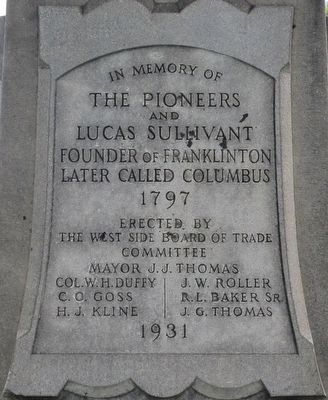
In this churchyard stood the first church of the community, The First Presbyterian Church, built and presented to the congregation in 1811 by Lucas Sullivant.
Here in this plot of ground, which he gave to the pioneers, he . . . — — Map (db m88307) HM
On North Davis Avenue at River Street, on the right when traveling south on North Davis Avenue.
This ancient burial ground of Central Ohio was established in a bend of the Scioto River in 1799 and is known as "Old Franklinton Cemetery". The pioneers buried here are about one hundred in number. Seventy-one graves are marked largely by sandstone . . . — — Map (db m88301) HM
Near River Street at North Davis Avenue, on the left when traveling east.
“Why lovely friend indulge that tear!
Why trembling view my dark abode;
Though you with me must moulder here,
Yet faith can wing the soul to God”
Rebecca (Culbertson) Smith
Born Sept. 28, 1798
Died Feb. 7, 1828 . . . — — Map (db m88313) HM
On West Broad Street (Old National Road) (U.S. 40) west of South Roys Avenue, on the left when traveling west.
Camp Chase was named in honor of Salmon P. Chase, former governor of Ohio and Secretary of the Treasury in President Abraham Lincoln’s Cabinet.
In July 1861, a small prison was erected at Camp Chase to handle the influx of political prisoners . . . — — Map (db m135244) HM
On Sullivant Avenue at Chestershire Road, on the right when traveling west on Sullivant Avenue.
(Side A): Camp Chase was a Civil War camp established in May 1861, on land leased by the U.S. Government. Four miles west of Columbus, the main entrance was on the National Road. Boundaries of the camp were present-day Broad Street (north), . . . — — Map (db m12078) HM
Panel 1
Camp Chase Prison
When President Abraham Lincoln called for volunteers to suppress the southern rebellion in April 1861, thousands of men rushed to Camp Jackson in Columbus, Ohio. Authorities established Camp Chase after . . . — — Map (db m94551) HM
On Sullivant Avenue, on the left when traveling east.
This Confederate Cemetery
has been listed in the
National Register
of
Historic Places
by the
U.S. Department of The Interior
1973 — — Map (db m166681) HM
On High Street near Indian Springs Dr., on the right when traveling north.
The Treaty of Greeneville temporarily ended the Indian Wars and
opened the west to white settlers. Kihue (aka Bill Moose), a
Native American and member of the Wyandotte tribe, was born
in Ohio in 1837. By 1846 all but twelve Wyandotte families . . . — — Map (db m116830) HM
On High Street at Indian Springs Dr., on the right when traveling north on High Street.
Philologus Webster was born in Stonington, Connecticut in 1759.
He was the son of Captain John and Rhonda Lewis Webster and the
great great grandson of Connecticut Colony Governor John Webster.
At the age of 18, Philo served in the Revolutionary . . . — — Map (db m116831) HM
On McKinley Avenue, 0.5 miles south of Trabue Road, on the right when traveling south.
Campbell Memorial Park. James E. Campbell was governor of the State of Ohio from 1890-1892. From 1913-1924, he served as president of the Ohio Archaeological and Historical Society, which later became the Ohio Historical Society. His daughter . . . — — Map (db m36726) HM
On McKinley Avenue, 0.5 miles south of Trabue Road, on the right when traveling south.
One of the last remaining earthen mounds in this area of Ohio. Built by Native American people of the Adena Culture (800 BC-100 AD). The land was deeded to the Ohio Historical Society in 1928 by the Shrum Family. — — Map (db m36869) HM
On West North Street at North High (Route 745), on the right when traveling west on West North Street.
Indian Run
Cemetery
established 1813
restored 1975- 1980
Dublin Historical Society
This property has ben placed on the National Register of Historic Places by the United States Department of the Interior.
Indian Run Cemetery. Jane . . . — — Map (db m101967) HM
The trustees of Mifflin Township dedicate this rostrum to all veterans of all wars as a token of appreciation and as a living memorial.
Killed in Action or Died in Service:
Roy R. Coleman •
John R. Gerber •
Morris E. Hester •
Paul C. . . . — — Map (db m14448) HM
In Memory
of
All Americans
who served their country
in
The Spanish-American
War
1898 1902
[Metal dedication marker]:
Dedicated to
the founders
Oscar Brookins-CMH-George Kelly
Walker Waddington . . . — — Map (db m12529) HM
On Gabriel's Run Drive at Gabriel's Landing Drive, on the left when traveling south on Gabriel's Run Drive.
There are 48 known members of the Postle family buried in the cemetery. Their stories are interwoven with the history of Prairie Township, Franklin County, and Ohio. In 1810, Shadrach and Anna Stacia Postle were among the first settlers of Prairie . . . — — Map (db m35718) HM
Original Board - January 15, 1908
Charles N. Graul - President 23½ yrs
Henry W. Voeller - President 16 yrs
Otto Willert - Secretary 29 yrs
Fred Kientz - President 14 yrs
Superintendent - 30 yrs
Wayne W. . . . — — Map (db m12911) HM
On Wilt Road, 0.1 miles west of Walnut Street, on the right when traveling east.
Built on Main Street, circa 1815, this two story log residence was later sided. In 1974 during new post office site preparation, the log structure was discovered and moved to present location along Ohio-Erie Canal route. In adjoining Groveport . . . — — Map (db m12521) HM
John S. Rarey (1827-1866), born in Groveport, became internationally famous for his revolutionary horse-taming methods based on his strong belief in kindness to animals. The principles of his training system were kindness, patience, and firmness. . . . — — Map (db m12518) HM
On Johnstown Road (U.S. 62) north of New Albany Expressway (Ohio Route 161), on the left when traveling north.
Smith’s Burying Ground was established in 1814 when John Smith (born 1742), Revolutionary War veteran, died and was buried here. John Smith and four of his sons and their families made the six week, six-hundred-mile journey from New Jersey with ox . . . — — Map (db m40277) HM
On Central College Road (County Road 18) at Cedar Brook Drive, on the left when traveling east on Central College Road.
In 1820, Mark Evans, John Davis, and Jacob Waggoner acquired from Daniel Triplett an 18-rod-square parcel (approximately two acres) at this location on which to build the first school in Plain Township. Education was not publicly funded at the . . . — — Map (db m40646) HM
On Riverside Drive (U.S. 33), on the right when traveling north.
Last of the Wyandots. Born 1837 and whose death in 1937 marks the passing of the Indians from this territory.
Engraved by Zenker Brothers — — Map (db m17430) HM
Here, in 1829, at the corner of Dempsey and Hempstead Roads was established a cemetery in connection with Blendon Central Church. This site was selected by the Blendon Presbyterian Assembly. Being the geographic center of the township, this served . . . — — Map (db m26670) HM
Dedicated to the Glory of
Almighty God in memory
of the men and women
who by their unselfish
patriotism have so
gallantly advanced the
American Ideals of
Freedom and the
Universal Brotherhood
of All Mankind
Dedicated this . . . — — Map (db m26673) HM
the son of Timothy Phelps,
the son of Cornelius Phelps,
the son of Timothy Phelps,
the son of William Phelps,
who came from Tewksbury
England in 1630 and
setteled at Dorchester, Mass.
In 1635, setteled Widsor, Conn.
[illegible]
He . . . — — Map (db m26674) HM
On Dublin-Granville Road (Ohio Route 161) 0.1 miles east of High Street (U.S. 23), on the right when traveling east.
Saint John's Church of Worthington and Parts Adjacent
In October of 1803, members of The Scioto Company, led by James Kilbourne, came from Connecticut and founded Worthington. On February 6, 1804, the Articles of Agreement establishing St. . . . — — Map (db m12650) HM
On County Road F, 0.4 miles west of County Road 26, on the left when traveling west.
On June 24th, 1836, Peter F. and Catherine M. Goll along with their 2 year old son, Peter F. Jr., embarked from Grand-Charmont, Doubs, France to come to America.
After 2 ½ months on the ocean they landed in New Amsterdam, (New York) and . . . — — Map (db m172017) HM
Near Adrian Street north of Maplewood Street, on the left when traveling north.
(Plaque 1)
Soldiers
Memorial-
- Monument
Dedicated to the memory
of the soldiers of all wars
1923
"Greater love hath no man than this, that
a man lay down his life for his friends."
St. John. . . . — — Map (db m172004) WM
On Ohio Route 109 south of County Road F, on the right when traveling south.
William and Elizabeth King and their children James, John, Elizabeth, Jane,
Mary, Catherine and William after selling their land holdings in Ireland, were
among the first pioneers in this area, purchasing Section 24, June 4, 1834,
in the Six . . . — — Map (db m171990) HM
On Ohio Route 109 just south of County Road F, on the right when traveling south.
The Kings, a family of staunch Presbyterians, were active in the Underground
Railroad. From 1838 to the end of the Civil War, here, at the John King Farm,
a network of extended families operated an Underground Railroad Station.
Following the . . . — — Map (db m227746) HM
On Ohio Route 109 just south of Route F, on the right when traveling south.
William King, a Presbyterian clergyman, of Scottish and
English ancestry, was born in Londonderry, Northern Ireland
and died in Canada at the age of eighty-two. He is buried
in the Maple Leaf Cemetery at Chatham, Ontario, Canada.
The Old King . . . — — Map (db m171989) HM
On County Route 4, on the left when traveling north.
St. John's Evangelical
Lutheran Church was the first
Lutheran Congregation to
serve the Swanton Area.
It was established in the year
1900 and a one room building
was soon constructed in 1901
to serve as a place of worship.
The congregation . . . — — Map (db m171980) HM
On Cemetery Street, on the left when traveling west.
In memory of those
who made the supreme
sacrifice, and in honor
of those who served
their country in the
World Wars
Korea
Vietnam
Grenada
Panama
Persian Gulf — — Map (db m171983) WM
On Cemetery Street west of Maple Street, on the left when traveling west.
(Side 1)
God Bless Our Native Land.
In Memoriam By W.R.C. No. 6, 1894.
(Side 2)
Resting The Battle Fought And Won.
Soldiers Of 1861-1865.
(Side 3)
One Country One Flag.
Our Fallen Heroes.
(Side . . . — — Map (db m178820) WM
On County Road 102, on the left when traveling north.
Council Oak Of the three things for which the site is historically important, only one survives - the famous Council Oak. Given the power of speech, the great tree could tell a stirring story of council meetings, torture of war prisoners, and . . . — — Map (db m100804) HM
On Pine Street (Ohio Route 160), on the right when traveling north.
A native of South Hadley, Massachusetts, he came to Gallipolis ca. 1818. An eminent lawyer and member of U.S. Congress 22 years, he was chairman of the House Ways and Means Committee during the Mexican War, founding father of the U.S. Department of . . . — — Map (db m30494) HM
On Pine Street (Ohio Route 160), on the right when traveling north.
Here sleep many of the French Five Hundred
who founded Gallipolis in 1790 and hundreds
of their descendants and others who won
honors in the service of their city and
country. Their names are recorded in stone
and their deeds in the . . . — — Map (db m30612) HM
On Pine Street (Ohio Route 160), on the right when traveling south.
Side A:
This 4-acre plot, established ca. 1860 by John Gee, is a burial ground for local colored citizens. John Gee was a religious leader as well as a skilled carpenter who built houses in early Gallipolis. Some Gallipolis colored pioneers . . . — — Map (db m30493) HM
On Goodwin Street, 0.2 miles east of Cheshire Street, on the right when traveling west.
Side A
Welton Cemetery was known as Roselawn Cemetery until the early 1900s. Early settlers to the Burton area donated the land. Welton Cemetery is the burial place for veterans of the nation's wars and for several state officials. Judge . . . — — Map (db m122782) HM
On North Main Street (Route 72) 0.1 miles north of Alumni Drive, on the left when traveling north.
Cedarville North Cemetery
Has Been Designated A
National
Historic Landmark
This Site Possesses National Significance in Commemorating the History of the United States of America
February 11, 1988
George W. Harper . . . — — Map (db m161219) HM
In Grateful Remembrance
this public state park has been created
through the generosity of public- spirited
citizens of Greene county who donated the
land. The prehistoric Indian-mound known
as the “Williamson Mound” thus will . . . — — Map (db m118376) HM
On Brush Row Road west of U.S. 42, on the right when traveling west.
The son of an enslaved father and free Black mother, Martin Delany
became one of the most prominent Black leaders in 19th Century
America. Called the “Father of Black Nationalism,” Delany promoted
African American pride and . . . — — Map (db m120157) HM
On Jones Road (County Route 86), on the right when traveling east.
Left Post1776 1931
James Stevenson donated
the Associate Church †
three acres for church and
cemetery purposes in 1804,
to be known as Massie’s
Creek Church lot and †
cemetery.
The Rev.
Robert . . . — — Map (db m214658) HM WM
Cedar Cliff Chapter
Daughters of the American Revolution
Dedicated Memorial Day
(logo) 1975 (logo)
to honor the memory of these men who served
their country in the American Revolution
William Bull, Sr. • William . . . — — Map (db m201692) WM
On Lincoln Road just east of Glendale Milford Road (Ohio Route 126), on the right when traveling east.
Waldschmidt Cemetery is located on land purchased from former New Jersey judge and Congressman John Cleves Symmes in 1795 by Christian Waldschmidt, one of the first settlers in the Little Miami River Valley. Waldschmidt, from Lancaster, . . . — — Map (db m134918) HM
The Church
Families of Salem settlement first held services in Francis McCormick's log home. When he gave land in 1817 for a church and public school, they built a log church on this site, later replacing it with a brick building. In 1863 the . . . — — Map (db m19922) HM
On Old Ludlow Avenue, 0.1 miles north of Ludlow Avenue, on the right when traveling north.
The Clifton location of Jewish Cemeteries of Greater Cincinnati was founded in 1848, as a resting place for deceased members of Congregation Ahabath Achim, an Orthodox Jewish congregation that later merged with Shearith Israel, and then with Isaac . . . — — Map (db m187352) HM
Columbia Baptist Cemetery
On the higher ground at the end of this lane
is Columbia Baptist Cemetery, the last
resting place of many of the pioneers who
came with Major Benjamin Stites and founded
Columbia, November 18, 1788, the first . . . — — Map (db m134948) HM
Columbia Presbyterian & Fulton Cemeteries The cemetery dates to 1794 and is comprised of two adjacent cemeteries: Columbia Presbyterian Cemetery and Fulton Cemetery. Another cemetery, the Fulton Mechanics Cemetery, had been in Fulton, a village . . . — — Map (db m134942) HM WM
Near Spring Grove Avenue, 0.5 miles west of Mitchell Avenue, on the right when traveling west.
Spring Grove Cemetery has been designated a National Historic Landmark. This site possesses national significance as the original site and model for the landscape-lawn concept that dominated American cemetery design from the mid 19th century . . . — — Map (db m171864) HM
Near Spring Grove Avenue,, 0.5 miles west of Mitchell Avenue, on the right when traveling west.
Spring Grove received its charter by an act of the Ohio Legislature in January 1845. Motivated by crowded conditions of small
cemeteries created by the cholera epidemics of the 1830s and
1840s, the Cincinnati Horticultural Society formed a . . . — — Map (db m171854) HM
On Central Avenue at Chestnut Street, on the left when traveling north on Central Avenue.
Chestnut Street Cemetery. Chestnut Street Cemetery is the first Jewish cemetery in Ohio and the earliest west of the Allegheny Mountains. It was established in 1821 when Nicholas Longworth sold land to Joseph Jonas, David I. Johnson, Morris . . . — — Map (db m243113) HM
Near Cleves Warsaw Pike, 0.2 miles west of Glenway Avenue (Ohio Route 264), on the left when traveling west.
(front)
Powhatan Beaty
Born in Richmond, Virginia. Powhatan Beaty moved to Cincinnati in 1849, where he spent the majority of his life. Beaty enlisted as a private in the Union Army in June 1863, and two days later was promoted . . . — — Map (db m87543) HM
Congress Green Cemetery
John Cleves Symmes had grand ambitions. He planned to build a large city here, making it the hub of the Northwest Territory. This very spot would be the middle of a bustling town square.
Things worked . . . — — Map (db m167342) HM
On Cliff Road just north of Brower Road, on the right when traveling north.
William Henry Harrison was the first
president to die in office. He served
only thirty-two days. The nation had
never before mourned a sitting president.
Harrison's body was placed in a glass
covered coffin in the East Room of the
White . . . — — Map (db m167348) HM
side A
Judge John Cleves Symmes of New Jersey
purchased a huge tract of land "between the Miamis"
(rivers) stretching from the Ohio River to the
Greenville Treaty Line that became known as the
Miami Purchase. Symmes helped found the . . . — — Map (db m82016) HM
On Springfield Pike (U.S. 4), on the right when traveling south.
In 1801, the Springdale Presbyterian Church acquired these two and a half acres to construct a church and cemetery. Although
the church moved to a new location in 1833, the cemetery remained
and continued to receive regular internments until the . . . — — Map (db m133110) HM
Near McManness Avenue south of Cherry Street, on the right when traveling north.
Tell Taylor is buried in the family plot Van Horn Cemetery 6 miles S.E. near the scenes of his childhood. An appropriate monument was erected at his grave by Findlay Elks #75. — — Map (db m228525) HM
On Van Buren Street west of River Street, on the right when traveling west.
Presented by Rachel G. Linhart. Dedicated to the memory of John M. Rachel G. and Helena M. Linhart.
John M. Linhart Private Co. H 7th Regt. Virginia Vol. Infantry.
Antietam — — Map (db m245425) WM
On Lynn Valley Pike, 0.2 miles south of County Route 106, on the left when traveling south.
Approximately 1000 feet east of this marker lies the graves of sixteen American soldiers from Fort McArthur who gave their lives during the War of 1812. The fort, a one-half acre timber stockade containing huts, was built in the summer of 1812 to . . . — — Map (db m22250) HM
On Ohio Route 309 east of Jacob Parrot Rd. (Ohio Route 171), on the right when traveling west.
In Memory of
Jacob Parrott
buried here. Born July 17, 1843 in Fairfield County, Ohio. Died December 22, 1908. At 18 he enlisted in Company K, 33rd Ohio Volunteer Infantry Regiment and was the youngest member of the famous Andrews Raid. The . . . — — Map (db m2022) HM
On U.S. 250, 0.2 miles east of Local Highway 215, on the right when traveling east.
Tappan was platted by John Marshall on March 4, 1837, on the main highway between Cadiz and New Philadelphia. One of the town's best-known residents was Mary Jobe Ackley (sic), who gained international fame as an explorer, author, lecturer, and . . . — — Map (db m36525) HM
On County Road 5A, 0.2 miles south of County Road P, on the left when traveling north.
Olive Branch Cemetery was established in 1874 on Rd. 5A. It
was donated by Wm. Cromwell to the Olive Branch Class of
the Methodist Evangelical Church which stood directly across
the road. This frame church building was later moved to the . . . — — Map (db m194461) HM
On County Road 17 at County Road Q1, on the left when traveling north on County Road 17.
On February 26, 1867, Henry Precht and his wife Louise sold to St. Paul's
Lutheran Church a one-half acre plot of land on the northwest corner of what are
now Roads 17 and QI for S15.00. It was on this plot of land that the church was
built . . . — — Map (db m172720) HM
On County Road 17 at County Road Q, on the left when traveling north on County Road 17.
First Bell and New Foundation
The original church remained much like it had been constructed the first
eighteen years. In 1886 the church got its first bell at a cost of $319.51. The same
year a new concrete foundation was also . . . — — Map (db m172721) HM
On East Riverview Avenue (Route 424) just north of East Clinton Street, on the left when traveling east.
The Miami & Erie Canal stretched approximately 250 miles from Cincinnati to Toledo. Napoleon and other towns on the Maumee River's banks were on a slackwater section of the canal. Between 1825 and 1845, laborers constructed the canal using . . . — — Map (db m160264) HM
On County Route 17 east of County Route Q, on the right when traveling north.
The congregation laid much emphasis upon the Christian instruction of
its children. For that purpose a parish school was maintained for many
years.
On August 18, 1887, it was decided to authorize the trustees to purchase
one acre of land for a . . . — — Map (db m172718) HM
Near North Washington Street (Ohio Route 41) north of Massie Street, on the right when traveling north.
Erected by
James H. Freshour
of
Co. I. 81st Regt. O.V.V.I.
to the memory of
the Union soldiers
of
Greenfield and vicinity
of the War of the Rebellion
1861-1865 — — Map (db m122544) WM
On North High Street at West Main Street (Ohio Route 73), on the left when traveling north on North High Street.
In honor of the Revolutionary soldiers buried in Highland County, Ohio.
Samuel Adkins • James Anderson • Benjamin Arthur • Azor Bagley • John Beard • Andrew Beatty • William Bell • Thomas Bernard • William Boatman • Thomas Brady • Daniel . . . — — Map (db m235377) WM
On Washington Street at Grant Ct., on the left when traveling west on Washington Street.
Governor Charles Willing Byrd
was the son of Colonel William Byrd of
Virginia. In 1792 President John Adams
appointed him secretary of the Northwest
Territory and in 1802 he became acting
governor of the territory. He was a
delegate to the . . . — — Map (db m121877) HM
On County Road 229, on the left when traveling east.
Side A:
This area, known as Calmoutier, was an early French Catholic farming community founded in 1832 by Claude Druhot, who came from Calmoutier, Hte-Saône, France. Its first native, the four-month-old Claude Joseph Druhot, was baptized on 9 . . . — — Map (db m24492) HM
Near Salem Road (County Road 176) 0.5 miles west of State Route 124, on the left when traveling west.
In memory of
the Unknown Confederate Soldiers
who served under
General John Hunt Morgan
and died July 17, 1863
at the Battle of Berlin Heights
Berlin Crossroads, Ohio — — Map (db m212252) WM
525 entries matched your criteria. Entries 201 through 300 are listed above. ⊲ Previous 100 — Next 100 ⊳