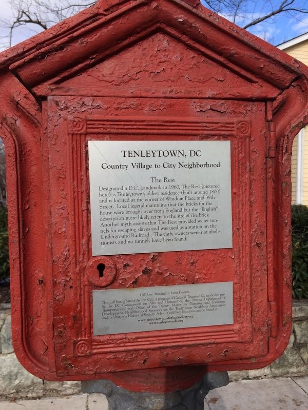
On Yuma Street Northwest at 39th Street Northwest, on the right when traveling west on Yuma Street Northwest.
Designated a D.C. Landmark in 1960, the Rest (pictured here) is Tenleytown's oldest residence (built around 1800) and is located at the corner of Windom Place and 39th Street. Local legend maintains that the bricks for the house were brought over . . . — — Map (db m112187) HM
Near Lincoln Drive Northwest north of Upshur Street Northwest, on the right when traveling north.
President Lincoln and his family lived in this country home for over a quarter of his presidency. Escorted by his cavalry guard, Lincoln rode to the White House every morning either on horseback or by carriage, and returned here each evening to . . . — — Map (db m52838) HM
On 6th Street Northwest at Indiana Avenue Northwest, on the right when traveling south on 6th Street Northwest.
To your right at the end of Indiana Avenue is Washington's first City Hall/Courthouse. Across Sixth Street is the H. Carl Moultrie I Courthouse, a successor to the original courthouse. The Old City Hall/Courthouse opened in 1822, with . . . — — Map (db m56124) HM
On 15th Street Northwest north of Pennsylvania Avenue Northwest, on the right when traveling north.
A Famed orator and writer Frederick Douglass was also a key architect of the movement that ended slavery, the very institution into which he was born. Even after his goal to abolish slavery was achieved, Douglass persisted in his struggle for . . . — — Map (db m92084) HM
On G Street Northwest east of 14th Street Northwest, on the right when traveling east.
Harriet Tubman escaped a life of slavery only to return south, at her own peril, time and again, to lead more than 300 fugitive slaves through the Underground Railroad to safety and freedom. After the Civil War, Tubman raised money to clothe and . . . — — Map (db m91877) HM
On 14th Street Northwest at F Street Northwest, on the left when traveling north on 14th Street Northwest.
Julia Ward Howe (1819-1910) was a poet, author, composer, abolitionist, suffragist and more—but she is most remembered for writing the lyrics to The Battle Hymn of the Republic. According to the story, she and her husband were asleep at the . . . — — Map (db m141266) HM
On 15th Street Northwest just south of Constitution Avenue Northwest (U.S. 50), on the left when traveling north.
Welcome to the Reading Grove
This space provides a place to meet, rest, read, and reflect. Live oaks have long harbored gatherings, from religious services and classes to community celebrations.
Witness Trees
Trees that were . . . — — Map (db m143315) HM
On 15th Street Northwest just south of Constitution Avenue Northwest (U.S. 50), on the left when traveling south.
Building the Nation
The use of live oaks played a critical role in helping the nation grow from a colony to what it became—the United States of America. Ships were an essential means of transportation for moving people and products, and . . . — — Map (db m143312) HM
On W Street Northwest west of 14th Street Northwest, on the left when traveling east.
Mary Ann Shadd Cary House
Has been designated a
National Historic Landmark
This site possesses national significance
In commemorating the history of the
United States of America.
An African American renaissance woman, . . . — — Map (db m182687) HM
On W Street Northwest west of 14th Street Northwest, on the left when traveling east.
When the lists of African American “firsts” are read, Mary Ann Shadd Cary’s name is everywhere. Born in Delaware to a free Black abolitionist family, Cary (1823-1893) moved to Canada in 1850 and ran a racially integrated school. Her anti-slavery . . . — — Map (db m61813) HM
On U Street Northwest at 17th Street Northwest, on the right when traveling west on U Street Northwest.
Police Call Boxes such as this one (originally painted blue) were installed in the District after the Civil War. Officers on foot patrol used this secure telegraph system to contact the station, accessing the box with a now highly collectible . . . — — Map (db m129486) HM
On 21st Street Northwest just west of L Street NW, on the right when traveling south.
“… a humble tribute of grateful remembrance to the late Thaddeus Stevens … the earnest champion of free and equal school privileges for all classes and conditions…” —the Board of Trustees of Colored Schools of Washington and Georgetown in honor . . . — — Map (db m282012) HM
On Marion Barry Avenue Southeast east of Martin Luther King Jr Avenue Southeast, on the right when traveling east.
The African Diaspora Ancestral Commemoration Institute (ADACI) is a Washington D.C. nonprofit 501(c)(3) founded in 1992, which institutionalizes the commemoration of the millions of African ancestors who perished during the Middle Passage — the . . . — — Map (db m294008) HM
Near W Street Southeast at 14th Street Southeast, on the left when traveling west.
Also known as Cedar Hill, this site encompasses the estate owned by Frederick Douglass from 1877 until his death in 1895. In honor of Douglass’ work as an author, orator, abolitionist, statesman, and civil rights leader, this site is designated a . . . — — Map (db m40846) HM
On W Street Southeast at 14th Street Southeast, on the right when traveling east on W Street Southeast.
This imposing property once belonged to Anacostia’s most famous resident: Frederick Douglass. After escaping slavery as a young man, Douglass rose to become a distinguished abolitionist, writer, publisher, and orator. By the 1860s Douglass . . . — — Map (db m88723) HM
On Anacostia Drive Southeast north of South Capitol Street Southeast, on the right when traveling west.
The Frederick Douglass Memorial Bridge stands as a tribute to Anacostia's most famous resident, abolitionist Frederick Douglass. Douglass often traveled along the Anacostia's banks on his way to work as publisher of the newspaper New National . . . — — Map (db m297964) HM
On Anacostia Drive 0.3 miles east of Good Hope Road Southeast, on the left when traveling east.
The "Freedmen's Bureau" acquired 375 acres of land that was originally a tobacco plantation from the Barry Family in the late 1800's. In 1867, the land was named Hillsdale by African Americans who came to Washington in great numbers before and . . . — — Map (db m141635) HM
Near E Street Southeast at Potomac Avenue Southeast, on the right when traveling south.
Ann G. Sprigg ran a boarding house, where Abraham Lincoln lived during his time as a U.S. Representative from Illinois (March 4th 1847 to March 3rd, 1849), at the present-day site of the Library of Congress Jefferson Building. The Sprigg . . . — — Map (db m211910) HM
On E Street Southeast at Potomac Avenue Southeast, on the right when traveling east on E Street Southeast.
For Anna & Frederick Douglass, their work, home, & life centered on abolition, & fair treatment & respect for African Americans.
Anna met Frederick, an enslaved 17-year-old in 1838. They fell in love; she encouraged, & financed his flight . . . — — Map (db m211913) HM
Near E Street Southeast 0.1 miles east of Potomac Avenue Southeast, on the right when traveling east.
Patriot John Smilie (1741-1812) joined the militia when the Revolutionary War began, leaving his Pennsylvania farm in the care of his wife. He was elected to the Pennsylvania state legislature in 1784. A vocal abolitionist, Smilie was instrumental . . . — — Map (db m141886) HM
On Henderson Street south of E Street Southeast, on the right when traveling south.
For close to 100 years, Lucy Bell struggled to keep her family safe, free, and united. Born a slave on a Prince George's County plantation before the Revolutionary War, Bell learned at a young age the stark reality of being someone else's . . . — — Map (db m266036) HM
Near E Street Southeast just east of Potomac Avenue Southeast, on the right when traveling east.
Historic Congressional Cemetery is the final resting place of four significant contributors to the Underground Railroad.
William Boyd •
John Dean •
David A. Hall •
Hannibal Hamlin — — Map (db m141883) HM
Near Frederick Douglass Court Southeast north of Bruce Place Southeast. Reported unreadable.
Three years after he escaped enslavement, Douglass gave a brief speech at an anti-slavery meeting in New Bedford, Massachusetts. This lecture would be the beginning of a repertoire of speeches that built Frederick Douglass's reputation as one of the . . . — — Map (db m129792) HM
On Frederick Douglass Court Southeast north of Bruce Place Southeast, on the right when traveling north.
Frederick Augustus Washington Bailey fled enslavement in Maryland on September 3, 1838. His escape route included travel by train, ferry, and steamboat through Maryland, Delaware, Pennsylvania, and New York. Each tree in Escape Allée represents . . . — — Map (db m129785) HM
Near Frederick Douglass Court Southeast north of Bruce Place Southeast.
Frederick Augustus Washington Bailey arrived in New York with the aid of a free woman named Anna Murray. She followed him to New York, and eleven days after his arrival, they married. The couple continued to settle in New Bedford, Massachusetts, . . . — — Map (db m129790) HM
Near Frederick Douglass Court Southeast north of Bruce Place Southeast.
From his 1841 speech at a Massachusetts Anti-Slavery Society convention, until 1895 when he died suddenly at his Cedar Hill home in Washington, D.C., Frederick Douglass championed human rights. This memorial grove of scarlet oaks represent the . . . — — Map (db m129791) HM
On Independence Avenue Southwest west of 7th Street Southwest, on the right when traveling east.
"…in view from the windows of the Capitol, a sort of negro-livery stable, where droves of negroes were collected, temporarily kept, and finally taken to Southern markets …had been openly maintained for fifty years." Abraham . . . — — Map (db m129921) HM
On 7th Street Southwest at Maine Avenue Southwest, in the median on 7th Street Southwest. Reported missing.
Before the Civil War, Washington was a slave-holding city. But many of its citizens–especially free blacks and abolitionists–assisted freedom seekers at locations known as stops on the Underground Railroad.
The largest . . . — — Map (db m112455) HM
On Wharf Street Southwest at 7th Street Southwest, on the right when traveling west on Wharf Street Southwest.
In 1848, in the largest recorded escape attempt by slaves in US history, 77 men, women, and children attempted to flee on the 65-foot schooner Pearl, but were recaptured due to opposing winds. — — Map (db m112420) HM
Near District Square Southwest west of Wharf Street Southwest, on the right when traveling west.
In April 1848, the largest slave escape attempt on record in the Unites States took place at the Southwest Waterfront. Seventy-seven men, women, and children boarded the schooner Pearl to sail to freedom, but were ultimately recaptured. The . . . — — Map (db m110136) HM
On NE Cholokka Boulevard at Northeast Magnolia Avenue, in the median on NE Cholokka Boulevard.
Moses Elias Levy (1782-1854), a Moroccan born Jewish merchant, came to Florida after its cession from Spain to the United States in 1821. Before his arrival, Levy acquired over 50,000 acres in East Florida. In 1822, Levy began development on . . . — — Map (db m93854) HM
On West Georgia Street west of Aquilina Howell, on the left when traveling west.
Folklore linked Frenchtown to settlers who emigrated to the Lafayette Land Grant and later moved to town. Census and property records contradict this story. Researcher Julianne Hare advances two other possibilities. When the area was first platted . . . — — Map (db m229577) HM
Welcome! This short, accessible loop trail takes you around Shaw's Point. It passes through mangrove wetland and visits a unique upland pine/hardwood hammock. At several points you can visit the sandy shoreline for views of Tampa Bay.
Near Cape Florida Park Boulevard at South Crandon Boulevard, on the left when traveling south.
In the early 1820's, enslaved Africans, runaways, and "Black Seminoles" seeking freedom from slave catchers and plantation masters, secretly worked their way down to CAPE FLORIDA. They met with bold captains of sloops from the British Bahamas who . . . — — Map (db m79723) HM
On Fort Mose Trail east of N. Ponce de Leon Blvd. (U.S. 1).
On the shore of Robinson Creek, ¼ mile east of this marker, was the site of a Spanish mission for Indians left homeless during Queen Anne's War. Since 1688, Negro slaves from the English colonies had found refuge in Spanish St. Augustine. On . . . — — Map (db m126969) HM WM
Near Fort Mose Trail 0.2 miles east of Colon Avenue, on the right when traveling north.
Stumbling over gnarled roots and through thick shrubs, you find a break in the dense vegetation. You are shocked to see several figures: Black women resting in the shade of the trees. Like you, they wear tattered clothing and look tired and sore . . . — — Map (db m289607) HM
On Blanco Street north of South Street, on the left when traveling north.
St. Augustine’s most famous garage building began its life long before the automobile age. The crack running down the east wall from top to bottom shows the original length of the structure, before it was enlarged in the 1920s for automobile and . . . — — Map (db m154602) HM
On Charlotte Street at Cathederal Place, on the right when traveling north on Charlotte Street.
Lion of Anacostia
Born into slavery on Maryland's Eastern Shore, Frederick Douglass (1818-1895) rose to prominence as one of the nation's leading abolitionists in the years before the Civil War. Remembered as an author, publisher, orator, . . . — — Map (db m311556) HM
On North Public Square at West Cherokee Avenue, on the right when traveling south on North Public Square.
Pathways to Freedom: A Story in Every Stitch, by sculptor, Przemyslaw Kordys, was commissioned by the African American Quilt Documentation Project of Bartow County and donated to the City of Cartersville in an unveiling ceremony on May . . . — — Map (db m273626) HM
On U.S. 41 0 miles south of Crabtree Drive, on the left when traveling north.
“As between the loss of independence and the loss of slavery, we assume that every patriot will freely give up the latter -- give up the Negro slave rather than be a slave himself.”
Near Islands Expressway (U.S. 80), on the left when traveling east.
On April 13, 1862, following the Union capture of Ft. Pulaski during the Civil War, Maj. Gen. David Hunter issued General Orders No. 7 freeing those enslaved at the fort and on Cockspur Island. Hunter, an abolitionist advocating the enlistment of . . . — — Map (db m280516) HM
On Tommy Long Road west of High Bluff Road, on the left when traveling west.
As the army of Union Major General William T. Sherman marched to the sea in late 1864 many runway slaves followed. Each infantry core had a few hundred to several thousand slaves trailing behind. Federal soldiers were largely living off the land . . . — — Map (db m297590) HM
On 14th Street at Front Avenue, on the right when traveling west on 14th Street.
April 16, 1865, was Freedom Day for the enslaved people of Columbus who awoke that day as slaves and went to sleep that night free. That evening Union cavalry under Gen. James H. Wilson defeated the Confederate forces of Gen. Howell Cobb in a night . . . — — Map (db m297481) HM
On Reynolds Street at 12th Street, on the right when traveling east on Reynolds Street.
1818
The Georgia Legislature adopts measures that restrict African American property ownership and that require free persons of color to
register annually and pay a tax when moving into the state. The registry includes many residents of . . . — — Map (db m271413) HM
On Reynolds Street at 12th Street, on the right when traveling east on Reynolds Street.
"I take my pen in hand to give you a sketch of the proceedings of the 1st day of January (The Freedmen's 4th of July) in the City of Augusta, we met a Springfield Church, it being the largest colored church in the city." -Robert Kent, . . . — — Map (db m271414) HM
On Andrew Drive (County Route 41) 0.1 miles Spring Street (Georgia Route 47), on the right when traveling west.
James Osgood Andrew was born in Wilkes County, Georgia, on May 5, 1794, about 400 yards N.E. of this marker, the son of Rev. John Andrew and Mary Cosby Andrew. He was licensed to preach in the Ellam Methodist Episcopal Church, Broad River Circuit, . . . — — Map (db m17257) HM
On 5th Street north of Maine Street, on the left when traveling north.
Lincoln: ". . . I have no purpose directly or indirectly to interfere with the institution of slavery in the states where it exists. I believe I have no lawful right to do so. And I have no inclination to do so."
Douglas: ". . . Mr. . . . — — Map (db m156831) HM
On 24th Street (Illinois Route 96) at Jersey Street, on the left when traveling south on 24th Street.
On an August night in 1842, Dr. Richard Eells, an active Quincy Abolitionist in the 1830-40's, was transporting a runaway slave named Charley to a safer location when his carriage was stopped near this spot by a posse searching for Charley. . . . — — Map (db m156857) HM
"I regard (Richardson) as one of the truest men that ever lived; he 'sticks to judge Douglas through thick and thin" (A. Lincoln, 1860). Douglas composed the 1854 Kansas-Nebraska Act. William A. Richardson, another Quincyan and Douglas' . . . — — Map (db m58760) HM
On 5th Street north of Maine Street, on the left when traveling north.
Lincoln: We oppose the Dred Scott Decision, . . . because we think that it lays the foundation not merely of enlarging and spreading that evil [slavery] but that it lays the foundation of spreading that evil into the states themselves . . . . . . — — Map (db m156830) HM
On November 1, 1854 an incensed Lincoln attacked the immorality of slavery in a speech at Kendall Hall. Lincoln was awakened from a five-bear political slumber by Douglas's Kansas-Nebraska Act, attacking it in a series of speeches in . . . — — Map (db m149831) HM
On 5th Street south of Hampshire Street, on the right when traveling south.
Lincoln: ". . . reduced to its lowest element, slavery is no other than that between the man that thinks slavery is wrong and those who do not think it wrong. . . . We think it is a moral, a social, and a political wrong. . . . [Douglas] has, . . . — — Map (db m156822) HM
On 5th Street south of Hampshire Street, on the right when traveling south.
Douglas: "Let each state mind its own business, and let its neighbors alone - then there will be no trouble on this question. . . . If we will stand by that great principle, then Mr. Lincoln will find that this Republic can exist forever . . . — — Map (db m156824) HM
On 5th Street south of Hampshire Street, on the right when traveling north.
Lincoln: ". . . there is no reason in the world why the Negro is not entitled to all the natural rights enumerated in the Declaration of Independence . . . . I hold that . . . in the right to eat the bread . . . which his own hand earns he is . . . — — Map (db m156821) HM
"Who shall say, I am the superior, and you are the inferior?" asked Lincoln in July 1858. The Lincoln-Douglas Debates focused on slavery. During the October 13th Quincy debate Lincoln affirmed: "...in the right to eat the bread . . . — — Map (db m58798) HM
On 5th Street north of Maine Street, on the left when traveling north.
Lincoln: "We also oppose [slavery] as an evil so far as it seeks to spread itself. We insist upon a policy that shall restrict it to its present limits. We do not suppose on doing this that we infringe upon the Constitution. . . . . . — — Map (db m156828) HM
On Oak Street west of 5th Street, on the left when traveling west.
The courthouse, completed in 1848, was the county seat of Alexander County until 1864 when the county seat was moved to Cairo.
The building was constructed with local sandstone, hewn timbers, hand sawed boards, plaster, and with a split . . . — — Map (db m303525) HM
On 3rd Street (Illinois Route 127) at Main Street, on the right when traveling north on 3rd Street.
Illinois Confederacy Indians roamed this prairie land, rich in game, which became Illinois County of Virginia. Ceded in 1784 to the United States it was successively included in the Northwest, Indiana; and in 1809, Illinois Territory. Formed in . . . — — Map (db m34169) HM
On East Peru Street 0.1 miles east of South Bureau Valley Parkway/County Road 2100 E, on the left when traveling east.
This house was one of the most important stations in the Underground Railroad movement in Illinois. Runaway slaves were harbored by the Lovejoy family until arrangements could be made for them to travel to the next station on their way to Canada. — — Map (db m259404) HM
On Lovejoy Way at South Main Street (U.S. 34), on the left when traveling east on Lovejoy Way.
Lovejoy Way is a tribute to Owen Lovejoy. Lovejoy came to
Princeton in 1838 to minister at the Hampshire Colony
Church. He spent 17 years here. When he arrived, he
resided with the Butler Denham family, who lived on the
east edge of town. When . . . — — Map (db m253166) HM
On East Peru Street (U.S. 6) just west of 8th Street, on the right when traveling west.
This two-story frame structure was the home of abolitionist Owen Lovejoy, who was born in Maine in 1811. Lovejoy moved into the house in 1838, when he became a Congregationalist minister. He was leader in the formation of the Republican Party in . . . — — Map (db m310285) HM
On 1st Street at East Park Street, on the left when traveling north on 1st Street.
The First Congregational Church, built in 1855-56, was popularly known as the “Goose Pond” Church, because the site was once a water-filled area, home to flocks of wild geese and ducks. The church became a meeting center for numerous . . . — — Map (db m31118) HM
On E Street 0.1 miles south of West State Street ( Route 316), on the right when traveling south.
On September 18, 1858, Springfield attorney and former U.S. Congressman Abraham Lincoln debated U.S. Senator Stephen A. Douglas at the Coles County Fairgrounds during the senatorial campaign of that year. The Charleston debate was the fourth of . . . — — Map (db m184632) HM
On North Pike Street north of Route 133, on the right when traveling north.
This was the home of Dr. Hiram Rutherford, who was involved in 1847 in a case in which Abraham Lincoln represented a slaveholder. Rutherford and Gideon Ashmore harbored a family of slaves who had sought their help. The slaves belonged to Robert . . . — — Map (db m30877) HM
On North Pike Street north of Route 133, on the right when traveling north.
Top Section
Dr. Hiram Rutherford was a key person involved in Abraham Lincoln’s famous slave case, the only instance in his career where Lincoln represented the rights of a slave owner. Robert Matson brought slaves from Kentucky to work his . . . — — Map (db m30867) HM
On East 31st Street at South Prairie Avenue on East 31st Street.
The son of freed slaves, Paul Laurence Dunbar published his first collection of poetry entitled
"Oak and Ivy" in 1893. Early in his career, he edited a newspaper published by friend, Orville
Wright, of aviation fame. Dunbar later befriended . . . — — Map (db m299640) HM
Near 134th Place at St. Lawrence Avenue, on the right when traveling east.
Although Illinois was established as a "free" state in 1818, federal laws that had been enacted since 1793 permitted the recapture and return of runaway enslaved people within U.S. territory. Beginning in the 1830s, freedom seekers were . . . — — Map (db m261062) HM
On 134th Place at St. Lawrence Avenue, on the right when traveling east on 134th Place.
From the 1830s until the Civil War, many enslaved African descendants in the South escaped to Chicago on their way to freedom in Canada. Black and white abolitionists in the region were part of the networks of assistance known as the Underground . . . — — Map (db m261050) HM
On 134th Place at St. Lawrence Avenue, on the right when traveling east on 134th Place.
Prior to the Civil War, an estimated 3,000 to 4,500 African descendants traveled to the Chicago region to escape slavery in the South. Responding to their journeys, Black and White abolitionists in Chicago and across the region formed . . . — — Map (db m261052) HM
Near South Ashland Avenue south of West 21st Street, on the right when traveling north.
El Gobierno de Guanajuato entrega a Chicago esta estatua en memoria de
The Government of Guanajuato presents Chicago this statue in memory of
Miguel Hidalgo Y Costillá
(1753 - 1811)
Nació en Pénjamo, Guanajuato. . . . — — Map (db m255784) HM
On 35th Street near Cottage Grove Avenue, on the right when traveling west.
From 1847 until his death in 1861, Stephen Douglas was both a powerful U.S. senator and an influential Chicago resident. Douglas moved from Vermont to southern Illinois at age 20 to begin his career in law and politics, rising quickly among the . . . — — Map (db m235224) HM
On West Grace Street east of North Kostner Avenue, on the right when traveling west.
John and Phebe Gray were distinguished by their generosity and social conscience. In 1857 they donated land to build a township hall at Milwaukee and Irving Park Road. In 1888, they donated land to build St. John's Episcopal Church one block north . . . — — Map (db m309130) HM
On Lee Street west of Fargo Avenue, on the right when traveling south.
In the four-way presidential election of 1860, Illinois voters overwhelmingly cast ballots for northern Unionist candidates Abraham Lincoln and Stephen Douglas. Southern states feared that President Lincoln would move to abolish slavery once he took . . . — — Map (db m268649) HM WM
On Lake Street at 1st Avenue ( Route 171), on the right when traveling east on Lake Street.
Many Black slaves fled from the antebellum south and gained their freedom by secretly traveling through the "Underground Railroad" route during the mid 1800's. A "Ten Mile Freedom House" providing shelter for the "Underground Railroad" travelers . . . — — Map (db m231844) HM
On Maple Avenue east of Lyman Avenue, on the right when traveling east.
Israel and Avis Blodgett moved to Downers Grove in 1836. Israel Porter Blodgett, Sr. operated a blacksmith shop, and is credited with developing the self-scouring plow used to turn the Illinois prairie.
Israel & Avis Blodgett were against . . . — — Map (db m270857) HM
On Main Street near Grove Street, on the right when traveling south.
Born in Connecticut in 1789
Died in Downers Grove in 1867
Resident of Downers Grove since 1836
Samuel Curtiss was a volunteer in the War of 1812 and used his script to purchase land here. The Main Street Cemetery is located on part of his . . . — — Map (db m270479) HM
On Maple Avenue east of Lyman Avenue, on the right when traveling east.
Built in 1846, this home of Israel and Avis Blodgett is believed to have been an active stop on the Underground Railroad with Israel as a Conductor. Having settled in Downers Grove in 1836, the family was very active in the Abolitionist Movement and . . . — — Map (db m301771) HM
Near Main Street north of Grove Street, on the left.
As early as the 1830's slaves made their way to freedom crossing through Illinois on their way north to Canada. They traveled on the Underground Railroad. Downers Grove historians Montrew Dunham and Pauline Wandschneider tell us "The Underground . . . — — Map (db m270475) HM
On Maple Avenue east of Lyman Avenue, on the right when traveling east.
The Underground Railroad was not the railroad that exists today in Downers Grove. Instead it was an informal and secret network of meeting points, transportation routes and safe houses coordinated by a group of people called abolitionists, who were . . . — — Map (db m270856) HM
On Grace Street near Parkside Avenue, on the left when traveling south.
Built in 1839 and lived in by the Peck family until 1996, the Peck Homestead is significant locally, for the state of Illinois, and nationally as the home of Sheldon Peck, a radical abolitionist, keeper of a documented URR station and prolific . . . — — Map (db m255670) HM
On College Avenue near Washington Street, on the left when traveling east.
Before and during the Civil War, thousands of freedom seekers fled northward to escape bondage. Aided by abolitionists and other sympathetic allies, these men, women, and children often traveled by night on foot or by wagon, boat, or train. By day . . . — — Map (db m286023) HM
On 50 West Main Street (Illinois Route 15) at North 4th Street ( Route 130), on the right when traveling east on 50 West Main Street.
To Morris Birkbeck
Who in 1817 with George Flower founded the English settlement in Edwards County This memorial is erected by the Department of Illinois Woman's Relief Corps Auxiliary to the Grand Army of the Republic "In respect and gratitude . . . — — Map (db m154631) HM
On 4th Street near Gallatin Street, on the left when traveling south.
At the beginning of Lincoln's second term as a state representative, several southern legislatures were concerned that the Federal Government would abolish slavery in the District of Columbia. Most of the members of the Illinois Legislature . . . — — Map (db m42490) HM
Near Monroe Street 0.8 miles north of Washington Street, on the left when traveling east.
Born: July 16th, 1833, Suffield, Connecticut
Died: January 17th, 1895, Chicago, Illinois
A lawyer and Indiana state legislator, he became a popular orator in the 1850s and gave more than sixty speeches against the evils of slavery. He . . . — — Map (db m303672) HM
On Lodge Boulevard, on the right when traveling east.
An outspoken abolitionist, Lovejoy was owner and publisher of the Alton "Observer". His anti-slavery writings aroused dangerous animosity in the area. Three times his presses were destroyed by mobs, and replaced by the townspeople. The fourth time . . . — — Map (db m142763) HM
Near North State Street (U.S. 67) at County Road 1350N, on the right when traveling north.
You are standing in what once was known as Hickory Grove, a tiny settlement that included three log cabins and the Red House.
The four-room Red House, built in 1827, was the first frame home in this area. In 1830, the Red House was converted . . . — — Map (db m142827) HM
On Kimball Street at Dundee Avenue, on the right when traveling west on Kimball Street.
Mary Newsome Wheeler was only two years old when she and her mother, Minerva Newsome, boarded a boxcar in Mississippi and braved the nearly 600-mile train ride to Elgin as refugee slaves or "contraband."
She attended the old Brook Street school . . . — — Map (db m299986) HM
On Spring Street near Grove Avenue, on the right when traveling south.
Who are the people looking at you?
The "Promise of Elgin" mural serves as a constant reflection of who we are and a reminder of where we hope to go. Do you see yourself reflected in the Elgin community?
The "Making Space" project was . . . — — Map (db m299885) HM
On Main Street (Illinois Route 72) east of 8th Street ( Route 21), on the left when traveling west.
This New England style farmhouse was built circa 1848, by Samuel Wilder to resemble his former New York State home. Robert and Lucy Duff purchased this property in 1868; however, historians claim they lived at this location during the Civil War . . . — — Map (db m94312) HM
On South Third Street at West Main Street, on the left when traveling south on South Third Street.
Allan Pinkerton, famous detective, had his home and cooperage on this lot, 1844-1850. Here he sheltered and employed slaves escaping to freedom. After helping to capture some counterfeiters, he became deputy sheriff of Kane County in 1848. In 1850 . . . — — Map (db m55485) HM
The American Civil War was a major war between the United States (the "Union") and eleven southern slave states that declared their secession and formed the Confederate States of America, led by President Jefferson Davis. The Union, led by President . . . — — Map (db m272008) HM
On West Center Street east of Church Street, on the left when traveling east.
Before the abolition of slavery, a movement was established throughout the United States to help enslaved African Americans escape north into free states and Canada. Known as the "Underground Railroad," this network was comprised of communities, . . . — — Map (db m297045) HM
On East Van Emmon Street east of South Bridge Street ( Route 47), on the right when traveling east.
The northern boundary of Illinois as prescribed in the Ordinance of 1787 was an East and West line from the Southern tip of Lake Michigan at approximately 41° 38', passing through this region to the Mississippi River. When Illinois applied for . . . — — Map (db m193168) HM
On South Broad Street north of East Tompkins Street, on the right when traveling north.
Site of Beecher Chapel, first brick church in Galesburg, built in 1858 and named after its first minister, Edward Beecher. Often used as a stop on the Underground Railroad. Razed 1966. — — Map (db m230127) HM
On South Street, on the right when traveling east.
On October 7, 1858, Abraham Lincoln and Stephan A. Douglas met in Galesburg for the fifth of seven joint debates. From a platform erected along the east side of Old Main on the Knox College campus, Lincoln said: "He is blowing out the moral lights . . . — — Map (db m313291) HM
2111 entries matched your criteria. Entries 101 through 200 are listed above. ⊲ Previous 100 — Next 100 ⊳