On Malvern at Convention Blvd, on the right when traveling north on Malvern.
You are facing the only statue of Kenji Miyazawa outside of Japan. We are grateful to the Miyazawa family for permission to erect it here. It is our hope that you will appreciate his body of work, including the message contained in this poem, and . . . — — Map (db m130033) HM
Near Promenade Trail, 0.2 miles north of Reserve Street, on the right when traveling south.
As you view the formal entrance to Hot Springs National Park today, several pieces of the original architectural design from the 1890s are no longer present. For example, a distinctive stone and wood pavilion called the Bandstand graced the top of . . . — — Map (db m145650) HM
On West Court Street at South 3rd Street, on the right when traveling east on West Court Street.
Let us hold in honored memory those men from Greene County who gave their lives that mankind might hope for a better world. World War I Ranzi Adams • Lon Austin • Charles J. Barnett • Jimmie Bonds • Arlin Boone • Luther F. Bowlin • William B. . . . — — Map (db m151233) HM WM
On West 2nd Street west of South Main Street, on the right when traveling east.
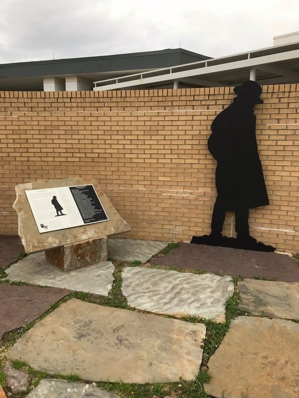
Created by the Randolph Rose Collection using the Lost Wax Cast Bronze method, these sculptures are titled "All Aboard." The Group Portrays a Train Conductor calling a woman and her daughter to catch a train in the 1920's.
First settled in . . . — — Map (db m246093) HM
Near North Magnolia Street south of Daugherty Street.
Born in Pennington, Ark on Jan. 4, 1937 to John and Itha Lewis. A legend in his time to those who knew him, Joe was a member of the Twitty Bird Band, of which he gave twenty years of service, bringing joy to the hearts of millions of people who . . . — — Map (db m207902) HM
On Southwest 2nd Street just south of West Main Street (U.S. 412), on the left when traveling north.
A quiet night in 1964 was interrupted by the unusual sound of an airliner approaching Walnut Ridge Airport. Its arrival sparked enough interest that three local teens went to investigate, only to discover John, Paul, Ringo and George walking from . . . — — Map (db m170608) HM
Near SW Front Street south of West Elm Street, on the right when traveling south.
Born along Rock 'n' Roll Highway 67 in
Pocahontas, Billy Lee Riley was known for
fronting one of the hottest rock bands on
the touring circuit. His four years at Sun
Records resulted in a number of singles
that influenced rock musicians for . . . — — Map (db m170391) HM
Near SW Front Street south of West Elm Street, on the right.
Carl Perkins delivered what many consider
the first big hit of rock 'n' roll music.
His "Blue Suede Shoes" in 1956 shot
to number one across a broad range of
music charts and became the first million-
selling single for Sun Records.
Perkins . . . — — Map (db m170395) HM
Near SW Front Street south of West Elm Street, on the right when traveling south.
With an astounding 55 number one hits to
his credit, Conway Twitty was a legendary
performer. Bụt while he is remembered
best as a country superstar, he started
his career and scored his first big hit as a
rockabilly singer. . . . — — Map (db m170389) HM
"Great Balls of Fire” was his signature hit, and the title could just, as easily
have described Jerry Lee Lewis himself. His unbounded energy on the
stage made Jerry Lee a nearly unrivaled performer, unlike anything most crowds had ever . . . — — Map (db m170386) HM
On SW Front Street south of West Elm Street, on the right when traveling south.
Northeast Arkansas native Johnny Cash
brought his own style to Rock 'n' Roll
Highway 67. His music was more country
than rock, but he produced an innovative
sound that enthralled fans for over five
decades.
Most of Johnny's shows along Rock . . . — — Map (db m170304) HM
Near SW Front Street south of West Elm Street, on the right when traveling south.
Before his trademark dark,
glasses and “Oh, Pretty Woman”.
made him a legend Roy Orbison
was a regular performer along
Rock 'n' Roll Highway 67. As a
recording artist with Sun Records
in the 1950s, Orbison was among
the musicians . . . — — Map (db m170402) HM
Near SW Front Street south of West Elm Street, on the right when traveling south.
Rock' n' Roll Highway 67 is more than
a collection of venues for Albert Austin
"Sonny" Burgess. It is home. The
rockabilly pioneer has always made his
home in Newport, and it was there that
he first made his name as an outstanding
musical . . . — — Map (db m170388) HM
On SW Front Street south of West Elm Street, on the right when traveling south.
Wanda Jackson created a sensation
in rockabilly music, and on Rock 'n'
Roll Highway 67. In-a music industry
dominated at the time by male performers,
Wanda stormed onto the scene while still a
teenager.
Porky's Roof Top in Newport was . . . — — Map (db m170965) HM
On SW 2nd Street north of West Elm Street, on the left when traveling north.
From the farm fields of Walnut Ridge to sold-out
halls in Chicago, Washboard Sam became a major
player on the blues scene in the 1930s and '40s.
Born Robert Brown on July 15, 1910, Washboard
Sam was a native son of Walnut Ridge, where
he was . . . — — Map (db m170300) HM
On Southwest 2nd Street, 0.1 miles south of West Main Street (U.S. 412), on the right when traveling south.
Newell Mock had a love for photography and a camera always at the ready. He captured these black and white images on September 20, 1964 as the Beatles returned to Walnut Ridge Airport from their weekend vacation at Pigman's Ranch in Missouri. John . . . — — Map (db m170243) HM
On Arkansas State Highway 234 at Local Highway 133, on the right when traveling south on Arkansas State Highway 234.
This property has been placed on the National Register of Historic places by the United States Department of the Interior.
Founders Odessa Smith, Newton Smith, Dan Smith, Thelma Skies, Shelba Clowdis
Alleene Birth Place of Chet Lauck The Lum . . . — — Map (db m172967) HM
On County Road 924, 0.3 miles east of State Route 77, on the right when traveling east.
Johnny Cash (1932-2003) was one of the most influential musicians of the
20th century. Successful with country, rock & roll, folk, blues, and gospel music, Cash sold over 90 million albums during his long career. Several of his songs reflect his . . . — — Map (db m160373) HM
On West Hale Avenue at South Poplar Street, on the right when traveling east on West Hale Avenue.
Moving to Osceola with his family at age 8, Blues legend Albert King (1923-1992) earned an early living picking cotton on nearby farms. King began his magnificent professional career in Osceola with his group, In The Groove Boys. King's T99 Club, . . . — — Map (db m36412) HM
On West Hale Avenue at South Poplar Street, on the right when traveling east on West Hale Avenue.
Billy Lee Riley began picking cotton at age 7 on the Jacksonville plantation in Osceola. Influenced by local bluesmen, Riley became a 1950s rockabilly star, recording his first hit, Flyin' Saucers Rock & Roll, at Sun Studios. Retiring from music . . . — — Map (db m36420) HM
On West Hale Avenue near South Poplar Street, on the right when traveling east.
Osceola native Jimmy Thomas split his youth working in cotton fields and playing local juke joints. As a teenager, he joined Ike Turner's Kings of Rhythm as lead singer, later performing with the Ike and Tina Turner Review. Settling in London, . . . — — Map (db m36419) HM
On West Hale Avenue at South Poplar Street, on the right when traveling east on West Hale Avenue.
Called the most prolific session guitarist of all time, Reggie Young grew up along the Cotton Highway in Osceola in the 1940s. Joining a multitude of famous artists, such as Johnny Cash, Elvis Presely, the Beatles, and Willie Nelson, Young has . . . — — Map (db m36409) HM
On West Hale Avenue at South Poplar Street, on the right when traveling east on West Hale Avenue.
Osceola native Frank "Son" Seals (1942-2004) began playing professionally at 13 with Robert Nighthawk, then, formed his own band at 17, touring with Albert King. Winner of three W.C. Handy Awards for best blues recording of the year, Seals' riveting . . . — — Map (db m36414) HM
On West Hale Avenue at South Poplar Street, on the right when traveling east on West Hale Avenue.
Osceola's own "Sweet Man," Willie Bloom, captured Southern cotton workers' sentiment with his legendary Blues music dating back to 1918. Bloom, whose recordings included "Osceola Blues," played alongside musical giants such as W.C. Handy, Jimmy . . . — — Map (db m36416) HM
Near West Cypress Street east of North New Orleans Avenue, on the left when traveling east.
Louis Jordan, born July 8, 1908, in Brinkley, Arkansas, was one of the
state's brightest musical stars, ruling the rhythm and blues charts of the
World War II era with hits like "Choo Choo Ch'Boogie," "Let the
Good Times Roll," "Is You Is or . . . — — Map (db m117265) HM
On West Cypress Street at North New Orleans Avenue, on the left when traveling east on West Cypress Street.
Willie Cobbs was born July 15, 1932 in Smale, a small farming town near Brinkley in Monroe County, Arkansas. Known as an American blues singer, harmonica player, songwriter, and nightclub owner, his recording career has spanned six decades. His . . . — — Map (db m172846) HM
On Porter Street west of Cherry Street, on the right when traveling west.
Traveling road shows, vaudeville, dog-and-pony shows, mind
readers, magicians, bell ringers and boxing matches-they all
appeared live at Helena's Grand Opera House. In the days before
radio, movies and television live entertainment was king. . . . — — Map (db m107996) HM
Helena has played a vital role in blues history for artists from both sides of the Mississippi River. Once known as a “wide open” hot spot for music, gambling, and nightlife, Helena was also the birthplace of “King Biscuit . . . — — Map (db m51907) HM
On Billstown Road, 0.8 miles north of State Highway 301, on the right when traveling north.
Legendary singer and guitarist Glen Campbell was born in Billstown, Arkansas on April 22, 1936. He died in Nashville, Tennessee on August 8, 2017 after a courageous battle with Alzheimer's disease. Campbell brought country music to the mainstream as . . . — — Map (db m184564) HM
On Zoo Drive, 0.5 miles south of Fair Park Boulevard, on the right when traveling east.
This bronze is one of four replicas of the famous Wild Boar of Florence located at the entrance of the Straw Market in that Historical Italian City. The original was carved in marble by the Greeks before the time of Christ. Later the Romans made a . . . — — Map (db m174255) HM
Dedicated August 6, 1933, as Pugh's Memorial Park, the Old Mill is a replica of an abandoned water-powered grist mill that would have been used by Arkansas pioneers in the 1800s. Although the Old Mill never actually operated as a mill, the iron . . . — — Map (db m53181) HM
On U.S. 62 at East Maple Street, on the right when traveling east on U.S. 62.
Billy Lee Riley was born in Pocahontas October 5,
1933. During his early childhood he lived just
off the Marr Street on Haw Street.
He recorded his first several hits, including
"Red Hot" at the legendary Sun Studio in Memphis
and his . . . — — Map (db m159744) HM
On Haw Street east of Schoonver Street, on the right when traveling west.
Rock and Roll pioneer Billy Lee Riley was born to Amos and Helen Riley on October 5, 1933 in a white frame house located on this site. Riley and his band, the Little Green Men, helped originate the unique sound of Sun Records that became a . . . — — Map (db m208461) HM
On Radio Drive at U.S. 62, on the left when traveling west on Radio Drive.
In the mid 1950s Elvis Presley's career was just beginning to take off. Elvis had made at least one record at Sun Studio in Memphis when he and his then manager made a stop at this location to request that his record be played on KPOC. He was . . . — — Map (db m207800) HM
On North Marr Street just north of West Jordan Street, on the right when traveling north.
Arkansas's first All-American in football was born in Pocahontas on this place, graduated from PHS and the U. of Arkansas at Fayetteville, accomplishing much both academically and in sports.
Schoonover was also 2nd team All-American in . . . — — Map (db m180434) HM
Founded in 1910 by C. D. "Bullet" Hyten, a master potter, the Niloak Pottery operated in Benton for 37 years. The unique multicolored spiral pieces were hand turned using natural colored clays dug from nearby "Pottery Hill." Niloak, kaolin spelled . . . — — Map (db m104026) HM
On Elton Britt Avenue just west of Center Street (State Highway 27), on the left when traveling west.
[side 1] Elton Britt, born James Elton Baker, came from the Zack community in Searcy County near the Buffalo River. Britt, from a musical family, was the first million seller in Country Music and received the first Gold Record . . . — — Map (db m229584) HM
On Garrison Avenue east of 10th Street, on the right when traveling east.
Ten years before the outbreak of the Civil War, the Old Red Mill stood on the future site of the New Theatre. The mill was used as a hospital during the Civil War, was damaged by the 1898 cyclone and finally disappeared around 1908. On the back . . . — — Map (db m92362) HM
On North McIlroy Avenue north of West Dickson Street, on the right when traveling north.
The Chi Omega Greek theater was built in
1930 as a gift from Chi Omega, the national
women's fraternity (sorority) that was
founded at the University of Arkansas in
1895 when four coeds and a faculty adviser
chartered the mother chapter, Psi. . . . — — Map (db m224250) HM
[Top plaque]
Built A.D. 1930
Chi Omega
Greek Theatre
has been placed on the
National Register
of Historic Places
by the United States
Department
of the Interior
[Bottom plaque]
The Chi Omega fraternity . . . — — Map (db m224254) HM
Near North Campus Walk north of West Dickson Street.
Founded in 1957 by Professor of Music Richard Brothers, this 32-voice mixed choir of University of Arkansas students quickly gained worldwide critical acclaim. In 1962, Schola Cantorum [Latin for 'school of singers'] became the first American choir . . . — — Map (db m224280) HM
On Central Avenue, 0.1 miles north of Main Street (State Highway 17), on the left when traveling north.
Rosetta Tharpe, considered gospel music's first crossover artist and a reputation "the original soul sister" and "Godmother of rock and roll." Born March 20 1915, in Cotton Plant Arkansas she began performing at age four. A singing and . . . — — Map (db m238212) HM
Donated to the city of Alameda in 1920 by Park Avenue resident Isabella Derby Clark, this concrete bench was designed by Myrtle Maillot. Mrs. Clark was a proponent of animal welfare. The inscription "In memory of my dumb friends" is a reference to . . . — — Map (db m101553) HM
On Buchanan Street, 0.2 miles west of San Pablo Avenue when traveling east.
This sculpture honors the Gill Family rose nursery that operated
during the late 19th to early 20th century in the area extending west
from San Pablo Avenue to Ocean View Park. It also honors the original
name of the City of Albany, which was . . . — — Map (db m137060) HM
Berkeley History
The Panoramic Hill Historic District typifies Berkeley’s early hillside neighborhoods. Steep and narrow Panoramic Way, carved out in 1888, opened the hill to residential development. University professors and early Sierra Club . . . — — Map (db m54694) HM
On Buena Vista Way, on the right when traveling east.
City of Berkeley Landmarks
designated in 1990
In 1901 architect Bernard Maybeck purchased ten acres of land here in La Loma Park. He built a sprawling brown shingle home for his family down the street in 1909 and subdivided the rest of his land . . . — — Map (db m53862) HM
Near Twain Avenue, on the right when traveling east.
City of Berkeley Landmark
designated in 1995
The Glass House is considered one of the best residential works of Wurster, who was the founding dean of UC Berkeley’s College of Environmental Design. This simply detailed, shed roof house was built . . . — — Map (db m53858) HM
On Miller Avenue at Ina Coolbrith Path, on the right when traveling west on Miller Avenue.
Ina Donna Coolbrith, California's first poet laureate and the nation's
first state laureate, was considered "the pearl of all her tribe” by her
19th century colleagues during the Bay Area's first literary heyday.
Born Josephine Donna Smith, . . . — — Map (db m152606) HM
City of Berkeley Landmark
designated in 2001
In 1919 John and Ada Hinkel donated seven hillside areas to the City of Berkeley in appreciation of the Boy Scouts’ service to the nation during the First World War. Before making their gift, the . . . — — Map (db m53849) HM
On Buena Vista Way, on the right when traveling east.
City of Berkeley Landmarks
designated in 1992
In one of Berkeley’s more eccentric experiments in living, Charles and Florence Boynton built their family residence as a version of a Greco-Roman temple with no walls. Two circular, open-air porches . . . — — Map (db m53864) HM
On Alston Way at Milvia Street, on the right when traveling east on Alston Way.
Chinaka Hodge
class of 2002, started writing and
performing poems as an awkward, pimply,
BHS freshman, and art-making
saved her life. She is a playwright,
poet and performer.
Phil Lesh
class of 1957, played the trumpet while
at . . . — — Map (db m154873) HM
On Allston Way east of Milvia Street, on the right when traveling east.
City of Berkeley Landmark
designated in 1991
Berkeley’s Elks Club, the 1002nd Chapter of the Benevolent and Protective Order of Elks, was founded in 1905, just in time for members to assist those displaced by the 1906 San Francisco Earthquake. . . . — — Map (db m54262) HM
On Center Street east of Shattuck Avenue, on the right when traveling east.
City of Berkeley Landmark
designated in 2006
This reinforced concrete building with its articulated brick facade and simple classical detailing was built for Harvey and Marie Ennor at a time of energetic downtown development. They expanded a . . . — — Map (db m54337) HM
On Milvia Street south of Center Street, on the right when traveling south.
City of Berkeley Landmark
designated 1985
The Farm Credit Administration built this structure to house federal agricultural banking and financial agencies, including one of the 12 Federal Land Banks that assisted Depression-era farmers. Features . . . — — Map (db m54258) HM
On Durant Avenue, on the left when traveling east.
City of Berkeley Landmark
designated in 1986
g. Paul Bishop Studio
Carl Fox, Designer
Fox Bros., Builders, 1938-39
Notwithstanding its steel-sash showcase window, this diminutive . . . — — Map (db m238704) HM
On Addison Street west of Shattuck Avenue, on the right when traveling west.
Listed on the National Record of Historic Places
In 1877, English immigrant John G. Wright founded the Golden Sheaf, Berkeley's first wholesale/retail bakery. The original bakery, with a public dining room, stood around the corner on Shattuck . . . — — Map (db m50360) HM
On Addison Street, on the right when traveling east.
In the 1940s painter David Park (1911-1960) had a studio in a brick building that once occupied this site. Despite a well-received exhibition of his abstract expressionist works at the San Francisco Museum of Art in 1948, Park rejected abstraction . . . — — Map (db m52388) HM
Near Shattuck Avenue north of Bancroft Way, on the right when traveling north.
City of Berkeley Landmark
designated in 1984
John Tupper and Lawrence Reed constructed this building for their music store, which they had established in Berkeley in 1906. University of California art professor Eugen Neuhaus complimented them . . . — — Map (db m54507) HM
On Oxford Street at Allston Way, on the right when traveling north on Oxford Street.
From 1885 to the end of his life his home stood about fifty yards east of this spot
"He who is a blessing for his time is a blessing for all time" — — Map (db m174416) HM
On College Avenue south of Ashby Avenue, on the right when traveling south.
Berkeley Repertory Theatre was founded in 1968 by U.C.
Dramatic Art student Michael Leibert, who wanted o create
an East Bay professional repertory company. Its first production, "Woyzek;” initially staged at the International
House, soon . . . — — Map (db m154321) HM
City of Berkeley Landmark
designated in 2005
This corner store was built for Stella King’s dry goods business and upstairs residence. Until the shop closed in 1923, it was a gathering place where neighbors could find everything from sewing . . . — — Map (db m54722) HM
On College Avenue south of Asby Avenue (California Route 13), on the right when traveling south.
City of Berkeley Landmark
designated in 1982
Built as the Strand Theater in the Art Nouveau architectural style, this was one of the neighborhood’s first commercial structures. Admission was ten cents for adults, five for children and the theater . . . — — Map (db m54813) HM
On Milvia Street just south of Lincoln Street, on the right when traveling south.
This garden honors Berkeley’s many innovative poets, poetry presses and publications, and their creative legacy. It was dedicated in 1999 on the second anniversary of “Beat” poet Allen Ginsberg’s death. Through their writings, the nonconformist . . . — — Map (db m54191) HM
On Virginia Street west of Shattuck Avenue, on the right when traveling west.
City of Berkeley Landmark
designated in 1984
This reinforced concrete Moderne-style building replaced an 1892 wood frame school. Faculty of the original school planted the five Coast Redwoods at the southwestern edge of the school grounds. The . . . — — Map (db m54192) HM
On Virginia Street, on the left when traveling east.
Robert Hale Merriman, a UC Berkeley graduate student studying economics during the early 1930s, was among the first Americans to give his life in the fight against fascism. During the Spanish Civil War, Merriman was a commanding officer of the . . . — — Map (db m152785) HM
Near Addison Street west of West Street, on the right when traveling west.
City of Berkeley Landmark
designated in 1986
Over the years this complex housed Cooper Woodworking, the Sperry Flour Company, the American Photoplayer Company, and other industrial and manufacturing enterprises. American Photoplayer manufactured . . . — — Map (db m53818) HM
On Telegraph Avenue at Dwight Way, on the right when traveling south on Telegraph Avenue.
Always go with nature, anywhere, in any circumstance, with gratitude.
The renowned and highly respected Japanese American artist Chiura Obata was a popular member of
the faculty at the University of California, Berkeley from 1932 to . . . — — Map (db m122842) HM
On Dana Street at Derby Street, on the right when traveling north on Dana Street.
From 1947 to 1968 this was the home of William Anthony Parker White (1911-1968),
universally known by the pen name Anthony Boucher. This Oakland-born author with a
master's degree from UC Berkeley was a pivotal figure in the establishment and . . . — — Map (db m136180) HM
On Adeline Street south of Alcatraz Avenue, on the right when traveling south.
Hiram Lovell, Architect, 1910, 1914
James W. Plachek, Architect, 1921
The popularity of early movies created a demand for new spaces to accommodate eager audiences. South Berkeley’s first neighborhood theater with 144 stools for seats was . . . — — Map (db m53816) HM
On Sacramento Street at Prince Street, on the right when traveling north on Sacramento Street.
Founded in 1945 by local sports hero Melvin Reid and his wife Betty Reid, Reid’s Records was one of the first Black-owned record shops in California and one of the few shops of any kind where African-American music could be purchased before the . . . — — Map (db m152805) HM
Near Shattuck Avenue north of Parker Street, on the right when traveling north.
Berkeley History
Horse-drawn wagons once carried goods to the Berkeley Free Market housed here. In 1952 the structure was modernized to accommodate automobile showrooms, with artist studios above. Richard Diebenkorn, Elmer Biscoff, William . . . — — Map (db m54333) HM
On Haste Street at Telegraph Avenue on Haste Street.
Mural designed by Osha Newmann, painted with O’Brien Thiele, Janet Kranzberg, Daniel Galvez and many others
Painted in 1976
Restored and enlarged in 1999
City of Berkeley Landmark
designated in 1990
The mural on this wall was painted . . . — — Map (db m54696) HM
City of Berkeley Landmark
designated in 2005
The Berkeley Piano Club, dedicated to the performance and study of music, was founded in 1893 by a group of local women. Early meetings were held in members’ homes and later in a barn at the . . . — — Map (db m54726) HM
On Folger Avenue west of Seventh Street, on the right when traveling west.
During the summer of 1969, the house at
835 Folger Avenue was home to the band
Commander Cody and his Lost Planet Airmen.
The band's style mixed country, rock 'n' roll,
western swing, rockabilly, and jump blues
together on a foundation of . . . — — Map (db m239011) HM
On Seventh Street south of University Avenue, on the right when traveling south.
Originally located at Sixth and Delaware streets, this simple wooden building was constructed by volunteers from the Workingman’s Club, a west Berkeley political organization. Built as a reading room for laborers, it was used briefly as Berkeley’s . . . — — Map (db m53836) HM
Near Gallaudet Drive north of Stevenson Boulevard, on the right when traveling north.
The sculptor of Bear Hunt, Douglas Tilden, was born on May 1, 1860, the day the California School for the Deaf first opened its doors in San Francisco. He became deaf at the age of four from scarlet fever. An 1879 graduate of CSD, Berkeley, he . . . — — Map (db m230584) HM
Along the ridge behind this panel lies a 52-acre parcel of historical significance. This farmstead known as “Ukraina” was the home of Ukrainian patriot, writer, and publisher Father Agapius Honcharenko. He and his wife Albina lived here . . . — — Map (db m26499) HM
“Ukraina” is the site of the farm and burial place of the Ukrainian patriot and exiled orthodox priest Agapius Honcharenko (1832-1916) and his wife Albina. Honcharenko was the first nationally conscious Ukrainian to arrive in the United States. He . . . — — Map (db m146447) HM
On Telegraph Avenue at 16th Street, on the left when traveling south on Telegraph Avenue.
Breonna Taylor was a black healthcare worker
from Louisville who became an iconic figure of
the 2020 Black Lives Matter uprising, the largest
protest movement in U.S. history. She was
murdered in her home by three plainclothes
police . . . — — Map (db m211516) HM
On Telegraph Avenue near Broadway, on the right when traveling south.
Edith Latham and her brother Milton had been gathering the memory of their parents in drawers, cabinets and living rooms until there was no longer space. Their need for a permanent storage site and longing to share the memories led them to imagine a . . . — — Map (db m72711) HM
On Broadway at Telegraph Avenue, on the right when traveling south on Broadway.
Latham Square is located in the
historic shopping and transportation
hub of downtown Oakland. The name
dates from dedication of the Latham
Fountain in 1913. The fountain was a
gift to the City and the local SPCA
from Edith and Milton Latham . . . — — Map (db m160463) HM
On Telegraph Avenue at Broadway, on the left when traveling south on Telegraph Avenue.
Live performance venues and movie theaters
once lined the streets downtown, with at least a
dozen as late as the 1950s. Many initially featured
vaudeville acts and silent films. The Fox and
the Paramount are the only two that remain . . . — — Map (db m160533) HM
Near Joaquin Miller Road at Sanborn Road, on the left when traveling east.
In the late 1800s, Joaquin Miller hosted gatherings of such notables as authors Jack London, Ambrose Bierce, Mark Twain, Bret Harte and Prentice Mulford; English humorist and playwright Tom Hood; illustrator/engraver Frank Leslie; poet Walt Whitman, . . . — — Map (db m71761) HM
Near Joaquin Miller Road at Sanborn Road, on the left when traveling east.
Joaquin Miller, “Poet of the Sierras,” resided on these acres, named by him “The Hights,” from 1886 to 1913. In this building known as The Abbey, he wrote “Columbus” and other poems. The surrounding trees were planted by him and he personally . . . — — Map (db m100546) HM
Near Joaquin Miller Road near Sanborn Road, on the left when traveling east.
The tiny cottage known as “The Abbey” was built by the 19th century poet and environmentalist Joaquin Miller as part of a inspirational artists’ retreat. He purchased 70 grassy acres, parcel-by-parcel, in “The Hights” above . . . — — Map (db m71759) HM
Near Sanborn Drive near Joaquin Miller Road, on the left when traveling north.
Joaquin Miller Park was formed in 1917 when the City of Oakland and its citizens – led by The California Writers Club – purchased 68 acres from the estate of Joaquin Miller, the noted 19th century “Poet of the Sierras” and . . . — — Map (db m71737) HM
On Sanborn Drive near Joaquin Miller Road, on the left when traveling north.
This 50-minute walk through the park features five rustic monuments. Four of them were hand-made by Joaquin Miller between 1892 and 1913. The walk is steep in places, but provides exhilarating views of the Bay and a visit to the Cascade. . . . — — Map (db m71736) HM
Two plaques are placed on Heinold's First & Last Chance Saloon. above
National Register of Historic Places
Heinolds’ First and
Last Chance Saloon
in continuous operation on this site
since 1883 and closely associated
with . . . — — Map (db m71296) HM
In 1886, ten year old Jack London traveled to Oakland with his family and led the rough and ready life of countless other working class lads of that era. Though he labored at menial jobs, the world of books captured his imagination at an early age . . . — — Map (db m71230) HM
Oakland’s famed native son was the noted author of “The Call of the Wild”, “The Sea Wolf” and “South Sea Tales”. He was at various times a sailor, Alaskan gold miner, salmon fisher and longshoreman.
For a time he was politically involved in . . . — — Map (db m71295) HM
In 1968 Russ Kingman, an area businessman with a passion for Jack London, headed an expedition to the Alaskan wilderness to authenticate a tiny cabin discovered in the woods on the north fork of Henderson Creek. The cabin was said to be the . . . — — Map (db m71293) HM
Near Embarcadero north of East 7th Street, on the left when traveling north.
From Oakland they came, their gifts many.
Caguate
1733-1803
Jalquin Bay Miwok, the last Oakland area tribal woman to join the Missions, 1808
Jausate
1764-1784
Huchiun Ohlone, first Oakland area tribal woman to move to Mission Dolores, . . . — — Map (db m220278) HM
On Mandela Parkway at 7th Street, on the right when traveling south on Mandela Parkway.
Spine of West Oakland
The elevated BART tracks are the latest link in Seventh Street's long history as the transportation spine of West Oakland. The street once led to the long Wharf and Mole on the western waterfront where the . . . — — Map (db m92787) HM
On 7th Street near Chester Street, on the left when traveling west.
Honoring the rich musical heritage of the Blues, Jazz and Gospel artists who played on 7th Street
Come explore and learn about a glorious brea in Oakland's musical history! The music they played on 7th Street, Oakland Walk of Game pays . . . — — Map (db m92754) HM
Near Wildwood Avenue near Prospect Road, on the right when traveling west.
“Loves Labor Lost,” a comedy by William Shakespeare, was the first play performed in the Eucalyptus Amphitheater in the spring of 1908. Set in a grove of trees for which it was named, the theater had a unique stage from which some of . . . — — Map (db m72377) HM
In May 1907, patrons of the arts from around the Bay Area descended on Piedmont Park for the opening of the Piedmont Art Gallery. On display were 375 oil, pastel and watercolor paintings in four separate galleries.
Under the guidance of . . . — — Map (db m72320) HM
On Main Street, on the right when traveling south.
Originally constructed as the New Lincoln Theatre
by the architectural firm of Miller and Warnecke,
this building housed Pleasanton's first moving picture
house and opened in 1927. In 1937 the theatre
became The Roxy Theatre after an ownership . . . — — Map (db m193941) HM
On West Main Street, on the left when traveling west.
Prior to 1914, theatergoers viewed silent movies and 'legitimate' shows in the Women's Pavilion at the west end of Main Street. Around this same time, Claude Violet operated the "Electric Theater" in another Ione location. His space was limited, so . . . — — Map (db m193579) HM
10562 entries matched your criteria. Entries 201 through 300 are listed above. ⊲ Previous 100 — Next 100 ⊳